ATL: IDA - Models
Moderator: S2k Moderators
Re: ATL: IDA - Models
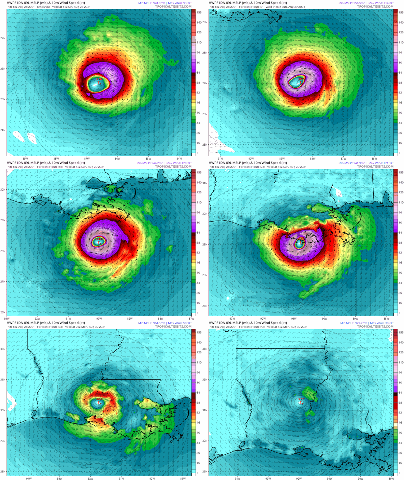
And Hwrf depicting 952 mb in 12 hrs and 130 mph.
And 944 at 18 with 140 mph nearing landfall.
24 hrs landfall over terrebonne Parish, 140 mph
Good bit stronger than prior runs.
And 944 at 18 with 140 mph nearing landfall.
24 hrs landfall over terrebonne Parish, 140 mph
Good bit stronger than prior runs.
3 likes
Re: ATL: IDA - Models
PTPatrick wrote:And Hwrf depicting 952 mb in 12 hrs and 130 mph.
And 944 at 18 with 140 mph nearing landfall.
24 hrs landfall over terrebonne Parish, 140 mph
Good bit stronger than prior runs.
Very interesting, and only about 24 out
3 likes
Once I see the REDS and GREENS Converge on a Base Velocity. ... I'm There!!
This is NOT an Official Forecast....Just my Opinion. For official information, please refer to the NHC and NWS products.
HIGHLIGHTS : '13 El Reno Tornado : 2013 Storm Chaser Tour, Joaquin; SC flood event, Matthew '16, Lowcountry Snow storm Jan '18
This is NOT an Official Forecast....Just my Opinion. For official information, please refer to the NHC and NWS products.
HIGHLIGHTS : '13 El Reno Tornado : 2013 Storm Chaser Tour, Joaquin; SC flood event, Matthew '16, Lowcountry Snow storm Jan '18
-
PandaCitrus
- Category 1

- Posts: 424
- Joined: Mon Sep 04, 2017 2:44 pm
Re: ATL: IDA - Models
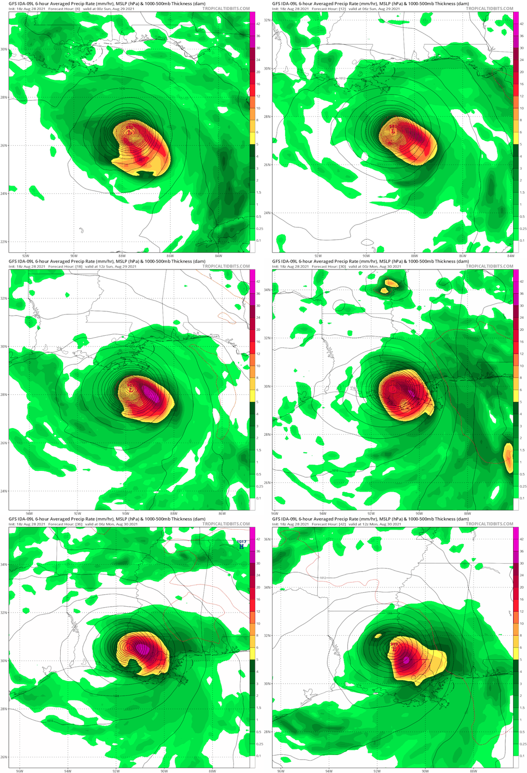
Really bad model trend east of track for New Orleans right now. They are in greater danger of getting hit with the eastern eyewall.
https://twitter.com/pppapin/status/1431755318623625221
https://twitter.com/pppapin/status/1431755318623625221
1 likes
Re: ATL: IDA - Models
Do models still show intensification till land fall?
0 likes
Personal Forecast Disclaimer:
The posts in this forum are NOT official forecast and should not be used as such. They are just the opinion of the poster and may or may not be backed by sound meteorological data. For official information, please refer to the NHC and NWS products.
The posts in this forum are NOT official forecast and should not be used as such. They are just the opinion of the poster and may or may not be backed by sound meteorological data. For official information, please refer to the NHC and NWS products.
-
tolakram
- Admin

- Posts: 20179
- Age: 62
- Joined: Sun Aug 27, 2006 8:23 pm
- Location: Florence, KY (name is Mark)
Re: ATL: IDA - Models
sikkar wrote:Do models still show intensification till land fall?
Yep, every one does, some stronger than others.
1 likes
M a r k
- - - - -
Join us in chat: Storm2K Chatroom Invite. Android and IOS apps also available.
The posts in this forum are NOT official forecasts and should not be used as such. Posts are NOT endorsed by any professional institution or STORM2K.org. For official information and forecasts, please refer to NHC and NWS products.
-
tolakram
- Admin

- Posts: 20179
- Age: 62
- Joined: Sun Aug 27, 2006 8:23 pm
- Location: Florence, KY (name is Mark)
Re: ATL: IDA - Models
For documentation, HWRF last run I'll post. Init too high, strength too low. Shows strengthening all the way in.


3 likes
M a r k
- - - - -
Join us in chat: Storm2K Chatroom Invite. Android and IOS apps also available.
The posts in this forum are NOT official forecasts and should not be used as such. Posts are NOT endorsed by any professional institution or STORM2K.org. For official information and forecasts, please refer to NHC and NWS products.
- - - - -
Join us in chat: Storm2K Chatroom Invite. Android and IOS apps also available.
The posts in this forum are NOT official forecasts and should not be used as such. Posts are NOT endorsed by any professional institution or STORM2K.org. For official information and forecasts, please refer to NHC and NWS products.
- cycloneye
- Admin

- Posts: 149283
- Age: 69
- Joined: Thu Oct 10, 2002 10:54 am
- Location: San Juan, Puerto Rico
Re: ATL: IDA - Models
I did not payed much atention to the models so my question is now that Ida made landfall, which one(s) performed the best?
0 likes
Visit the Caribbean-Central America Weather Thread where you can find at first post web cams,radars
and observations from Caribbean basin members Click Here
and observations from Caribbean basin members Click Here
Re: ATL: IDA - Models
cycloneye wrote:I did not payed much atention to the models so my question is now that Ida made landfall, which one(s) performed the best?
They all were running a bit too west near /after landfall for most of this forecast period but did really well. They all sort of adjusted together for the most part. Euro probably had a more pronounced west bias overall though, also hmon. Honestly they didn’t pick up on the more eastern landfall and track until late last night.
Hwrf nailed intensity.
4 likes
Re: ATL: IDA - Models
cycloneye wrote:I did not payed much atention to the models so my question is now that Ida made landfall, which one(s) performed the best?
Euro did good early on showing a Louisiana landfall while other models like the GFS were still insisting on a North Mexico or South Texas landfall.
3 likes
-
longhorn2004
- Tropical Depression

- Posts: 61
- Joined: Fri Oct 06, 2017 1:49 pm
Re: ATL: IDA - Models
Isn't Ida suppose to be sucking in dry air by now? Its one of the reason for the rapid reduction from Cat 4 to Cat 1. Suppose to be sucking in cool air from the northwest.
0 likes
Re: ATL: IDA - Models
The very first mention of New Orleans in this thread was regarding the 00z CMC run on the 25th of August. 06z GFS on the 25th of August also showed landfall just west of the city.
1 likes
-
tolakram
- Admin

- Posts: 20179
- Age: 62
- Joined: Sun Aug 27, 2006 8:23 pm
- Location: Florence, KY (name is Mark)
Re: ATL: IDA - Models
kevin wrote:The very first mention of New Orleans in this thread was regarding the 00z CMC run on the 25th of August. 06z GFS on the 25th of August also showed landfall just west of the city.
The CMC always hits New Orleans. It had to be right at some point.
This site at UAA tracks model verification for storms. Here's Ida: http://www.atmos.albany.edu/facstaff/ta ... /al092021/
Unfortunately these don't go back very far.
1 likes
M a r k
- - - - -
Join us in chat: Storm2K Chatroom Invite. Android and IOS apps also available.
The posts in this forum are NOT official forecasts and should not be used as such. Posts are NOT endorsed by any professional institution or STORM2K.org. For official information and forecasts, please refer to NHC and NWS products.
- - - - -
Join us in chat: Storm2K Chatroom Invite. Android and IOS apps also available.
The posts in this forum are NOT official forecasts and should not be used as such. Posts are NOT endorsed by any professional institution or STORM2K.org. For official information and forecasts, please refer to NHC and NWS products.
-
tolakram
- Admin

- Posts: 20179
- Age: 62
- Joined: Sun Aug 27, 2006 8:23 pm
- Location: Florence, KY (name is Mark)
Re: ATL: IDA - Models
Here's trend gifs from Tropical Tidbits for all the models that have them available. Remember to look at run time in the upper left. I am noting the date above each model where it first is close to an LA landfall.
Aug 25th

Aug 25th (late, penalized for having timing wrong)

Aug 26th (also timing wrong, tough call)

Aug 26th (not a lot of runs, and also timing. Pretty good for a model many ignore)

Whatever. (Limited runs, I went back manually and the storm just isn't there. If you love NAVGEM then check my work ... Steve )
)

Aug 25th

Aug 25th (late, penalized for having timing wrong)

Aug 26th (also timing wrong, tough call)

Aug 26th (not a lot of runs, and also timing. Pretty good for a model many ignore)

Whatever. (Limited runs, I went back manually and the storm just isn't there. If you love NAVGEM then check my work ... Steve

4 likes
M a r k
- - - - -
Join us in chat: Storm2K Chatroom Invite. Android and IOS apps also available.
The posts in this forum are NOT official forecasts and should not be used as such. Posts are NOT endorsed by any professional institution or STORM2K.org. For official information and forecasts, please refer to NHC and NWS products.
- - - - -
Join us in chat: Storm2K Chatroom Invite. Android and IOS apps also available.
The posts in this forum are NOT official forecasts and should not be used as such. Posts are NOT endorsed by any professional institution or STORM2K.org. For official information and forecasts, please refer to NHC and NWS products.
Who is online
Users browsing this forum: No registered users and 5 guests


