ATL: IDA - Remnants - Discussion

Moderator: S2k Moderators

Message
Author
User avatar
Meteorcane
Category 2
Category 2
Posts: 559
Joined: Thu Jul 21, 2011 6:49 am
Location: North Platte Nebraska

Re: ATL: IDA - Hurricane - Discussion

#3821 Postby Meteorcane » Sun Aug 29, 2021 7:46 am

xironman wrote:TOR warning Dauphin Island, that northern band will start lighting up with them.


Yep not-surprisingly tons of low-lvl SRH on the eastern side of the system

Image
1 likes   

tomatkins
Tropical Storm
Tropical Storm
Posts: 222
Joined: Wed Sep 05, 2018 2:11 pm

Re: ATL: IDA - Hurricane - Discussion

#3822 Postby tomatkins » Sun Aug 29, 2021 7:46 am

thoughtsinchaos wrote:How much do hurricanes usually add to hospitalizations? If Louisiana is at 90%+ capacity, is that unused 10% sufficient for a Cat 5 mass casualty event? EMS and hospitals are already stretched to breaking point in the entire southern US. Human toll of Ida seems set to be catastrophic https://i.imgur.com/NFKXGn3.png


I wouldn't think you'd get alot of hospitalizations. You kind of either survive or don't to put it grimly. But I would be concerned about an explosion of COVID in the area from people picking it up in shelters and such.
6 likes   

Airboy
Category 1
Category 1
Posts: 439
Joined: Wed Jul 27, 2011 10:41 am

Re: ATL: IDA - Hurricane - Discussion

#3823 Postby Airboy » Sun Aug 29, 2021 7:46 am

From NOAA plane:
Peak (10s) Flt. Lvl. Wind: 136 kts (156.5 mph)
SFMR Peak (10s) Sfc. Wind: 131 kts (150.8 mph)
0 likes   
Personal Forecast Disclaimer:
The posts in this forum are NOT official forecast and should not be used as such. They are just the opinion of the poster and may or may not be backed by sound meteorological data. They are NOT endorsed by any professional institution or storm2k.org. For official information, please refer to the NHC and NWS products.

Michele B
S2K Supporter
S2K Supporter
Posts: 1114
Joined: Thu Aug 25, 2016 8:08 am
Location: SWFL

Re: ATL: IDA - Hurricane - Discussion

#3824 Postby Michele B » Sun Aug 29, 2021 7:46 am

skyline385 wrote:
Stangfriik wrote:
skyline385 wrote:Are you taking about the eyewall elongating? Those are mesovotices


Yea where it has become more red rather than black and white. Thanks!

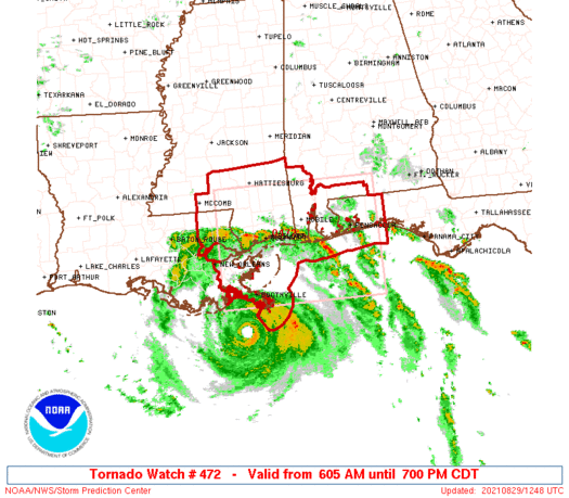
https://uploads.tapatalk-cdn.com/20210829/9eeb28531a934139a4b7e1986f3daa55.png


What means "Meso strength 1814" in that marker near the eastern eye wall?
1 likes   
Cleo - 1964, Betsy - 1965, David - 1979, Andrew - 1992, Charlie (Francis, Ivan, Jeanne) - 2004, Irma - 2017, Ian - 2022

Fancy1001
Category 1
Category 1
Posts: 452
Joined: Thu Jul 16, 2020 10:16 pm

Re: ATL: IDA - Hurricane - Discussion

#3825 Postby Fancy1001 » Sun Aug 29, 2021 7:47 am

123330 2834N 08929W 7515 02231 9705 +153 +171 175135 139 113 053 01
123400 2834N 08931W 7490 02221 9639 +176 +190 174114 136 131 025 01

Cat 5 yet
2 likes   

User avatar
Clearcloudz
Category 2
Category 2
Posts: 540
Joined: Sun Jun 10, 2018 1:46 pm
Location: Rosenberg TX

Re: ATL: IDA - Hurricane - Discussion

#3826 Postby Clearcloudz » Sun Aug 29, 2021 7:47 am

tolakram wrote:saved loop
https://i.imgur.com/j6VNwMi.gif


I really hope every state in the US sends help to the region in the coming days. They will need as much as possible.
1 likes   

User avatar
Teban54
Category 5
Category 5
Posts: 3208
Joined: Sat May 19, 2018 1:19 pm

Re: ATL: IDA - Hurricane - Discussion

#3827 Postby Teban54 » Sun Aug 29, 2021 7:47 am

The NOAA plane is still getting pressure readings in the 950s. I think we can say with confidence that something is wrong with that plane at this point.
4 likes   

User avatar
Hypercane_Kyle
Category 5
Category 5
Posts: 3354
Joined: Sat Mar 07, 2015 7:58 pm
Location: Cape Canaveral, FL

Re: ATL: IDA - Hurricane - Discussion

#3828 Postby Hypercane_Kyle » Sun Aug 29, 2021 7:47 am

131 knots in the eastern eyewall. May have missed the strongest winds just to the south.
3 likes   
My posts are my own personal opinion, defer to the National Hurricane Center (NHC) and other NOAA products for decision making during hurricane season.

Keldeo1997
Category 2
Category 2
Posts: 637
Joined: Fri Oct 11, 2019 11:35 pm

Re: ATL: IDA - Hurricane - Discussion

#3829 Postby Keldeo1997 » Sun Aug 29, 2021 7:47 am

4 likes   

RL3AO
Moderator-Pro Met
Moderator-Pro Met
Posts: 16308
Joined: Thu Jun 14, 2007 10:03 pm
Location: NC

Re: ATL: IDA - Hurricane - Discussion

#3830 Postby RL3AO » Sun Aug 29, 2021 7:48 am

Grand Isle is going to get the full force of the eastern eye and eyewall I think.
4 likes   

kronotsky
Tropical Depression
Tropical Depression
Posts: 52
Joined: Tue Oct 23, 2018 11:17 am

Re: ATL: IDA - Hurricane - Discussion

#3831 Postby kronotsky » Sun Aug 29, 2021 7:48 am

ChrisH-UK wrote:This is NOAA's Inundation map for the New Orleans area.

https://tidesandcurrents.noaa.gov/inund ... 1100000000

A lot of these stations look like they were already high, though below flood stage, even before Ida entered the picture. Has the lower Mississippi received a lot of rain recently?
1 likes   

TallyTracker
Category 2
Category 2
Posts: 734
Joined: Thu Oct 11, 2018 2:46 pm

Re: ATL: IDA - Hurricane - Discussion

#3832 Postby TallyTracker » Sun Aug 29, 2021 7:49 am

tomatkins wrote:
thoughtsinchaos wrote:How much do hurricanes usually add to hospitalizations? If Louisiana is at 90%+ capacity, is that unused 10% sufficient for a Cat 5 mass casualty event? EMS and hospitals are already stretched to breaking point in the entire southern US. Human toll of Ida seems set to be catastrophic https://i.imgur.com/NFKXGn3.png


I wouldn't think you'd get alot of hospitalizations. You kind of either survive or don't to put it grimly. But I would be concerned about an explosion of COVID in the area from people picking it up in shelters and such.


No you will get thousands of hospitalizations both directly from the storm and from injuries in the aftermath (cutting tree injuries, CO poisoning, etc.). It’s gonna be a major problem.
7 likes   
Fran '96, Georges '98, Gordon '00, Gabrielle '01, Charley '04, Frances '04, Jeanne '04, Barry '07, Fay '08, Debby '12, Matthew '16, Emily '17, Irma '17, Michael ‘18, Elsa ‘21, Fred ‘21, Mindy ‘21, Nicole ‘22, Idalia ‘23, Debby ‘24, Helene ‘24

KBBOCA
S2K Supporter
S2K Supporter
Posts: 1559
Joined: Fri Sep 05, 2003 5:27 am
Location: Formerly Boca Raton, often West Africa. Currently Charlotte NC

Re: ATL: IDA - Hurricane - Discussion

#3833 Postby KBBOCA » Sun Aug 29, 2021 7:49 am

0 likes   

User avatar
GCANE
S2K Supporter
S2K Supporter
Posts: 11500
Joined: Mon Oct 22, 2007 8:03 am

Re: ATL: IDA - Hurricane - Discussion

#3834 Postby GCANE » Sun Aug 29, 2021 7:50 am

FYI, Tornado Watch issued

Imageimage img
0 likes   

User avatar
ElectricStorm
Category 5
Category 5
Posts: 5049
Age: 24
Joined: Tue Aug 13, 2019 11:23 pm
Location: Skiatook, OK / Norman, OK

Re: ATL: IDA - Hurricane - Discussion

#3835 Postby ElectricStorm » Sun Aug 29, 2021 7:50 am

NOAA drop in E eyewall has ~140kt winds just above the surface :eek:
7 likes   
B.S Meteorology, University of Oklahoma '25

Please refer to the NHC, NWS, or SPC for official information.

User avatar
weeniepatrol
Category 5
Category 5
Posts: 1276
Joined: Sat Aug 22, 2020 5:30 pm
Location: WA State

Re: ATL: IDA - Hurricane - Discussion

#3836 Postby weeniepatrol » Sun Aug 29, 2021 7:51 am

Image
1 likes   

KBBOCA
S2K Supporter
S2K Supporter
Posts: 1559
Joined: Fri Sep 05, 2003 5:27 am
Location: Formerly Boca Raton, often West Africa. Currently Charlotte NC

Re: ATL: IDA - Hurricane - Discussion

#3837 Postby KBBOCA » Sun Aug 29, 2021 7:51 am

1 likes   

xironman
S2K Supporter
S2K Supporter
Posts: 2522
Joined: Sun Jun 10, 2007 4:53 pm
Location: NoVA

Re: ATL: IDA - Hurricane - Discussion

#3838 Postby xironman » Sun Aug 29, 2021 7:51 am

The looks like it is tightening up a bit on satellite, can't tell from radar. Land interaction could do it.
1 likes   

User avatar
Woofde
Category 1
Category 1
Posts: 481
Joined: Tue Jul 06, 2021 11:33 am

Re: RE: Re: ATL: IDA - Hurricane - Discussion

#3839 Postby Woofde » Sun Aug 29, 2021 7:51 am

Category5Kaiju wrote:What's even more interesting about Ida is the amount of jaw-dropping footage of its landfall that will be generated by storm chasers due to its daytime landfall.
There will be lots of wind videos, but I'm curious if anyone manages to get into the eye before it falls apart. The eye is expected to basically go directly over the swampland to the west of New Orleans. It's almost impossible to chase in there because of the surge and flooding risks. Someone would have to be very risky to do it.
7 likes   

User avatar
Hypercane_Kyle
Category 5
Category 5
Posts: 3354
Joined: Sat Mar 07, 2015 7:58 pm
Location: Cape Canaveral, FL

Re: ATL: IDA - Hurricane - Discussion

#3840 Postby Hypercane_Kyle » Sun Aug 29, 2021 7:51 am

148 knot flight level winds.

Dropsonde was 135 knots on the surface, but remember these are instantaneous winds.

VDM from AF305 shows the eye has contracted from 20 nautical miles to 16 nautical miles.
Last edited by Hypercane_Kyle on Sun Aug 29, 2021 7:54 am, edited 1 time in total.
3 likes   
My posts are my own personal opinion, defer to the National Hurricane Center (NHC) and other NOAA products for decision making during hurricane season.


Return to “2021”

Who is online

Users browsing this forum: No registered users and 0 guests