2021 Indicators: SST's / SAL / MSLP / Shear / Steering / Instability / Sat Images

This is the general tropical discussion area. Anyone can take their shot at predicting a storms path.

Moderator: S2k Moderators

Forum rules

The posts in this forum are NOT official forecasts and should not be used as such. They are just the opinion of the poster and may or may not be backed by sound meteorological data. They are NOT endorsed by any professional institution or STORM2K. For official information, please refer to products from the National Hurricane Center and National Weather Service.

Help Support Storm2K
Message
Author
User avatar
Teban54
Category 5
Category 5
Posts: 3206
Joined: Sat May 19, 2018 1:19 pm

Re: 2021 Indicators: SST's / SAL / MSLP / Shear / Steering / Instability / Sat Images

#2881 Postby Teban54 » Sun Aug 29, 2021 7:17 am

toad strangler wrote:
aspen wrote:Already at 9/4/2, and it’s only August 29th. No other season in this current active streak has had two majors before September; the last was 2010. August will probably finish off at 11/4/2 with the two depressions becoming Julian and Kate, but it’s possible TD10 becomes a hurricane in the subtropics if it survives the next few days. We’ll see a massive ACE boost from future Larry, which could be a long-tracking MDR major and stay away from land. By September 5th, we might be at 12/6/3.

Yeah the season for season cancel posts is pretty much done now.


That was done two weeks ago

Except for some who were still saying everything struggled except Grace. :lol:
4 likes   

IcyTundra
Category 5
Category 5
Posts: 1205
Joined: Mon Jun 07, 2021 9:32 pm
Location: Dickinson, Texas

Re: 2021 Indicators: SST's / SAL / MSLP / Shear / Steering / Instability / Sat Images

#2882 Postby IcyTundra » Sun Aug 29, 2021 10:00 am

EPS has some members that are awfully bullish on the next carribean storm.
0 likes   

Chris90
Category 2
Category 2
Posts: 646
Age: 35
Joined: Thu Jun 01, 2017 9:36 pm

Re: 2021 Indicators: SST's / SAL / MSLP / Shear / Steering / Instability / Sat Images

#2883 Postby Chris90 » Sun Aug 29, 2021 12:53 pm

It’s kind of hard to believe that the bell rung 9 days ago and we’ve already had 2 majors, both which made landfall at major hurricane strength.

This is what I was expecting last year. I’m not saying last year wasn’t terrible and active, because it absolutely was, it just felt off balance I guess because we were burning through names but didn’t have a major until Laura, and then we had another break from majors until Teddy I believe. This year isn’t burning through names quite as fast, but more storms are achieving higher intensities in regard to storm count to major ratio. So far 2021 is feeling like the mash up between 2017+2020 that no one asked for. Not at 2020’s pace, but the storms that do form are achieving higher intensities more consistently like 2017.
6 likes   
Solar Aquarian
Lunar Cancerian
:uarrow: Sagittarian

User avatar
captainbarbossa19
Professional-Met
Professional-Met
Posts: 1092
Age: 27
Joined: Wed Aug 21, 2019 11:09 pm
Location: Beaumont, TX

Re: 2021 Indicators: SST's / SAL / MSLP / Shear / Steering / Instability / Sat Images

#2884 Postby captainbarbossa19 » Sun Aug 29, 2021 1:17 pm

aspen wrote:Already at 9/4/2, and it’s only August 29th. No other season in this current active streak has had two majors before September; the last was 2010. August will probably finish off at 11/4/2 with the two depressions becoming Julian and Kate, but it’s possible TD10 becomes a hurricane in the subtropics if it survives the next few days. We’ll see a massive ACE boost from future Larry, which could be a long-tracking MDR major and stay away from land. By September 5th, we might be at 12/6/3.

Yeah the season for season cancel posts is pretty much done now.


One thing that is quite concerning is that both majors that formed were intensifying on approach to landfall. It seems like the strongest storms unfortunately are also forming in the western part of the basin. I think this is going to be a very long season.
0 likes   

User avatar
Hammy
Category 5
Category 5
Posts: 5849
Age: 41
Joined: Fri May 25, 2012 5:25 pm
Contact:

Re: 2021 Indicators: SST's / SAL / MSLP / Shear / Steering / Instability / Sat Images

#2885 Postby Hammy » Sun Aug 29, 2021 2:10 pm

CFS model from several weeks ago seems like it nailed the trend--Western Caribbean/Gulf is where the show is with some recurves otherwise.
0 likes   
The above post is not official and should not be used as such. It is the opinion of the poster and may or may not be backed by sound meteorological data. It is not endorsed by any professional institution or storm2k.org. For official information, please refer to the NHC and NWS products.

User avatar
aspen
Category 5
Category 5
Posts: 8818
Joined: Sat Oct 12, 2019 7:10 pm
Location: Connecticut, USA

Re: 2021 Indicators: SST's / SAL / MSLP / Shear / Steering / Instability / Sat Images

#2886 Postby aspen » Sun Aug 29, 2021 2:15 pm

Hammy wrote:CFS model from several weeks ago seems like it nailed the trend--Western Caribbean/Gulf is where the show is with some recurves otherwise.

One of the runs from late July correctly predicted a big storm in the Gulf during the last days of August, which has verified in the form of Ida.
0 likes   
Irene '11 Sandy '12 Hermine '16 5/15/2018 Derecho Fay '20 Isaias '20 Elsa '21 Henri '21 Ida '21

I am only a meteorology enthusiast who knows a decent amount about tropical cyclones. Look to the professional mets, the NHC, or your local weather office for the best information.

User avatar
WiscoWx02
Category 1
Category 1
Posts: 391
Joined: Sat Jul 31, 2021 8:09 pm

Re: 2021 Indicators: SST's / SAL / MSLP / Shear / Steering / Instability / Sat Images

#2887 Postby WiscoWx02 » Sun Aug 29, 2021 2:26 pm

Image
Image
Image

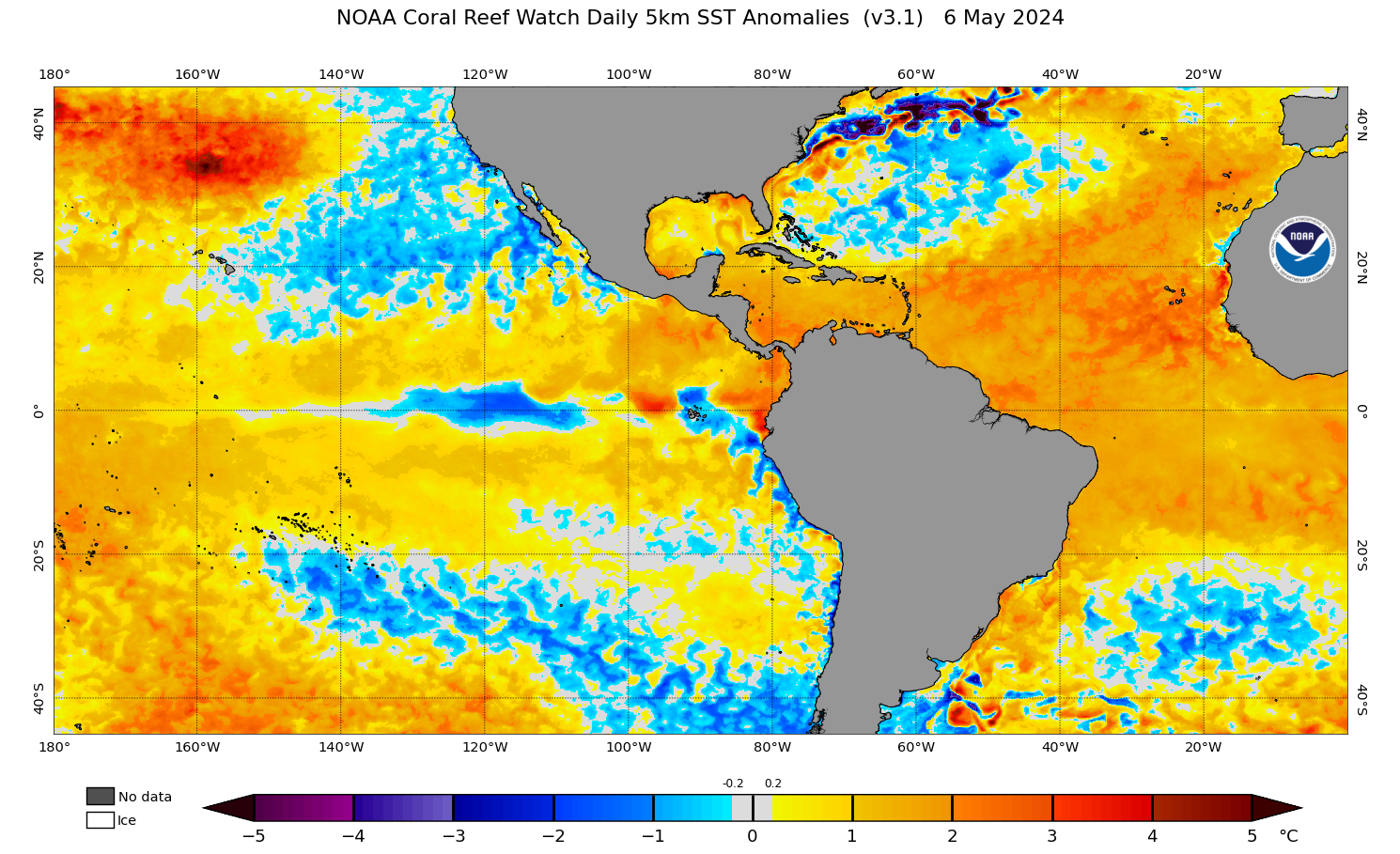
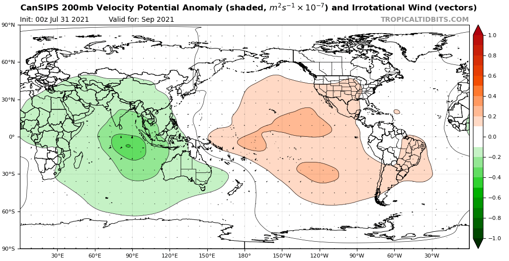
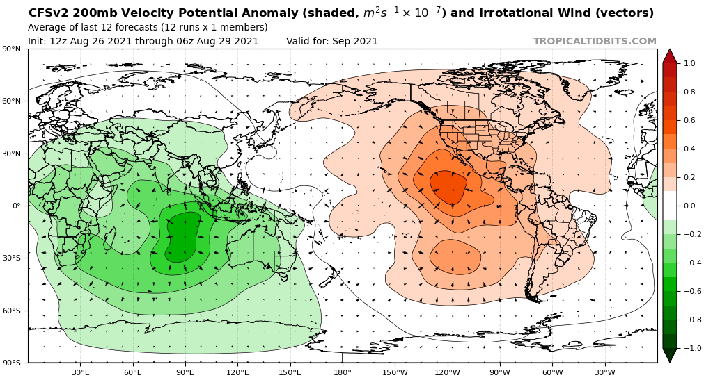
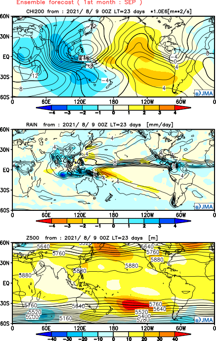
CFS showing as favorable of a look for September as you can get. Rising over western Indian Ocean, Africa and sinking in the eastern Pacific. SSTA's are pretty favorable now too with the entire MDR above normal and the Nino 1+2 area finally cooling down. Precip pattern looks somewhat active but not jaw dropping though which doesn't add up IMO but it's the CFS I guess. Probably going to be active for the next week and a half and then dead for a week then busy again dependent on Kelvin Wave activity.
1 likes   


IcyTundra
Category 5
Category 5
Posts: 1205
Joined: Mon Jun 07, 2021 9:32 pm
Location: Dickinson, Texas

Re: 2021 Indicators: SST's / SAL / MSLP / Shear / Steering / Instability / Sat Images

#2889 Postby IcyTundra » Sun Aug 29, 2021 3:17 pm

I would expect the NHC to make this a new AOI in the TWO.
0 likes   

User avatar
weeniepatrol
Category 5
Category 5
Posts: 1276
Joined: Sat Aug 22, 2020 5:30 pm
Location: WA State

Re: 2021 Indicators: SST's / SAL / MSLP / Shear / Steering / Instability / Sat Images

#2890 Postby weeniepatrol » Sun Aug 29, 2021 5:55 pm

Here's quite an indicator and let me tell you the fact that it's not even September has me feeling extremely uncomfortable right now.

Image
11 likes   

jhpigott
Category 2
Category 2
Posts: 570
Joined: Wed Jan 02, 2008 8:09 pm
Location: North Palm Beach, Florida

Re: 2021 Indicators: SST's / SAL / MSLP / Shear / Steering / Instability / Sat Images

#2891 Postby jhpigott » Sun Aug 29, 2021 6:47 pm

Whoops. Wrong thread
0 likes   

IcyTundra
Category 5
Category 5
Posts: 1205
Joined: Mon Jun 07, 2021 9:32 pm
Location: Dickinson, Texas

Re: 2021 Indicators: SST's / SAL / MSLP / Shear / Steering / Instability / Sat Images

#2892 Postby IcyTundra » Sun Aug 29, 2021 6:50 pm

Ida is just the beginning... I think we are in for at least 1 more major hitting the CONUS imo and August isn't even over yet still have all of September and October as well.
0 likes   

ThetaE
Tropical Storm
Tropical Storm
Posts: 244
Joined: Sat Sep 24, 2016 4:50 pm
Location: Boston

Re: 2021 Indicators: SST's / SAL / MSLP / Shear / Steering / Instability / Sat Images

#2893 Postby ThetaE » Sun Aug 29, 2021 7:00 pm

aspen wrote:Already at 9/4/2, and it’s only August 29th. No other season in this current active streak has had two majors before September; the last was 2010. August will probably finish off at 11/4/2 with the two depressions becoming Julian and Kate, but it’s possible TD10 becomes a hurricane in the subtropics if it survives the next few days. We’ll see a massive ACE boost from future Larry, which could be a long-tracking MDR major and stay away from land. By September 5th, we might be at 12/6/3.

Yeah the season for season cancel posts is pretty much done now.


It hasn't felt like this season has been abnormally active with last year's fervent pace fresh on the mind, but we're only two letters behind 2005! That year, Maria formed on Sep 1 and Lee on Sep 5. If we get 3 named storms quickly enough (TD 10, Caribbean, and MDR), we could temporarily tie or surpass that year in terms of named storms!
1 likes   
I'm a busy grad student, not a professional forecaster. Please refer to the NHC and NWS for official forecasts.

ThetaE
Tropical Storm
Tropical Storm
Posts: 244
Joined: Sat Sep 24, 2016 4:50 pm
Location: Boston

Re: 2021 Indicators: SST's / SAL / MSLP / Shear / Steering / Instability / Sat Images

#2894 Postby ThetaE » Sun Aug 29, 2021 7:01 pm

ThetaE wrote:
aspen wrote:Already at 9/4/2, and it’s only August 29th. No other season in this current active streak has had two majors before September; the last was 2010. August will probably finish off at 11/4/2 with the two depressions becoming Julian and Kate, but it’s possible TD10 becomes a hurricane in the subtropics if it survives the next few days. We’ll see a massive ACE boost from future Larry, which could be a long-tracking MDR major and stay away from land. By September 5th, we might be at 12/6/3.

Yeah the season for season cancel posts is pretty much done now.


It hasn't felt like this season has been abnormally active with last year's fervent pace fresh on the mind, but we're only two letters behind 2005! That year, Maria formed on Sep 1 and Lee on Sep 5. If we get 3 named storms quickly enough (TD 10, Caribbean, and MDR), we could temporarily tie or surpass that year in terms of named storms!


Sorry, Nate on Sep 5, not Lee.
0 likes   
I'm a busy grad student, not a professional forecaster. Please refer to the NHC and NWS for official forecasts.

User avatar
Category5Kaiju
Category 5
Category 5
Posts: 4097
Joined: Thu Dec 24, 2020 12:45 pm
Location: Seattle

Re: 2021 Indicators: SST's / SAL / MSLP / Shear / Steering / Instability / Sat Images

#2895 Postby Category5Kaiju » Sun Aug 29, 2021 7:23 pm

I think this season is beginning to really show its true colors now. With Grace and Ida (and with many strong ensemble members for the MDR system), I personally think reaching 3 major hurricanes by the beginning of September may not be a far stretch from what is possible. In terms of named storms, if TD10, the possible Caribbean system, and the MDR system are all named, that would conceivably bring us all the way to Nicholas by early to mid September or so. At this point I am going to say that reaching the far end of the naming list (perhaps even using all 21 names) could very well occur, and if a La Nina allows for late season activity to flourish, then we may even end up seeing at least Adria or Braylen by the season's end. In other words, I seriously think that this season has the potential to be very active and impactful, and who knows what kinds of threats September, October, and perhaps even November will bring?
0 likes   
Unless explicitly stated, all info in my posts is based on my own opinions and observations. Tropical storms and hurricanes can be extremely dangerous. Do not think you can beat Mother Nature. Refer to an accredited weather research agency or meteorologist if you need to make serious decisions regarding an approaching storm.

User avatar
toad strangler
S2K Supporter
S2K Supporter
Posts: 4543
Joined: Sun Jul 28, 2013 3:09 pm
Location: Earth
Contact:

Re: 2021 Indicators: SST's / SAL / MSLP / Shear / Steering / Instability / Sat Images

#2896 Postby toad strangler » Sun Aug 29, 2021 7:36 pm

ThetaE wrote:
aspen wrote:Already at 9/4/2, and it’s only August 29th. No other season in this current active streak has had two majors before September; the last was 2010. August will probably finish off at 11/4/2 with the two depressions becoming Julian and Kate, but it’s possible TD10 becomes a hurricane in the subtropics if it survives the next few days. We’ll see a massive ACE boost from future Larry, which could be a long-tracking MDR major and stay away from land. By September 5th, we might be at 12/6/3.

Yeah the season for season cancel posts is pretty much done now.


It hasn't felt like this season has been abnormally active with last year's fervent pace fresh on the mind, but we're only two letters behind 2005! That year, Maria formed on Sep 1 and Lee on Sep 5. If we get 3 named storms quickly enough (TD 10, Caribbean, and MDR), we could temporarily tie or surpass that year in terms of named storms!


Man I disagree. This season is ENFUEGO and has felt like it too.
2 likes   

AlphaToOmega
Category 5
Category 5
Posts: 1448
Joined: Sat Jun 26, 2021 10:51 am
Location: Somewhere in Massachusetts

Re: 2021 Indicators: SST's / SAL / MSLP / Shear / Steering / Instability / Sat Images

#2897 Postby AlphaToOmega » Sun Aug 29, 2021 7:43 pm

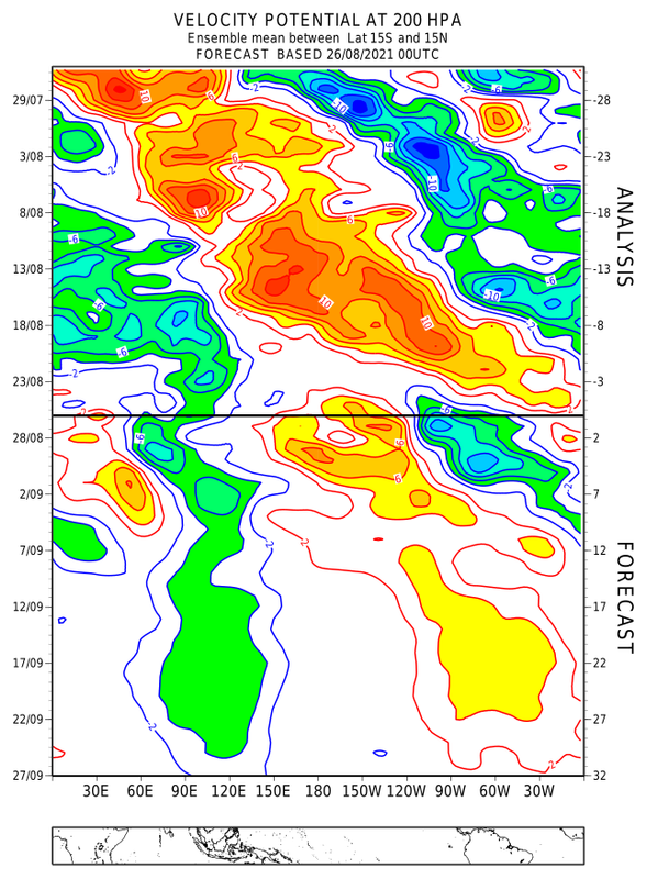
I believe it is safe to say that September will be very active.
Image
Image
Image
Image
0 likes   

User avatar
toad strangler
S2K Supporter
S2K Supporter
Posts: 4543
Joined: Sun Jul 28, 2013 3:09 pm
Location: Earth
Contact:

Re: 2021 Indicators: SST's / SAL / MSLP / Shear / Steering / Instability / Sat Images

#2898 Postby toad strangler » Sun Aug 29, 2021 7:45 pm

Category5Kaiju wrote:I think this season is beginning to really show its true colors now. With Grace and Ida (and with many strong ensemble members for the MDR system), I personally think reaching 3 major hurricanes by the beginning of September may not be a far stretch from what is possible. In terms of named storms, if TD10, the possible Caribbean system, and the MDR system are all named, that would conceivably bring us all the way to Nicholas by early to mid September or so. At this point I am going to say that reaching the far end of the naming list (perhaps even using all 21 names) could very well occur, and if a La Nina allows for late season activity to flourish, then we may even end up seeing at least Adria or Braylen by the season's end. In other words, I seriously think that this season has the potential to be very active and impactful, and who knows what kinds of threats September, October, and perhaps even November will bring?


Climatology says that the CONUS has a day or two short of 9 weeks left. Barring some crazy anomalous situation like the far SW Atlantic Basin saw well into November last year.
0 likes   

User avatar
aspen
Category 5
Category 5
Posts: 8818
Joined: Sat Oct 12, 2019 7:10 pm
Location: Connecticut, USA

Re: 2021 Indicators: SST's / SAL / MSLP / Shear / Steering / Instability / Sat Images

#2899 Postby aspen » Sun Aug 29, 2021 8:00 pm

We could be at 4 majors by mid-September, depending on how the 40/80 wave and the possible WCar system progress. The former looks like it’ll probably be a high-ACE fish major, and after what happened with Grace and Ida, any Caribbean/Gulf storm needs to be watched VERY closely.

I’m praying that if anything starts forming in the Caribbean, it better stay the hell away from Louisiana. 4 Cat 2+ landfalls in 12 months is more than enough.
1 likes   
Irene '11 Sandy '12 Hermine '16 5/15/2018 Derecho Fay '20 Isaias '20 Elsa '21 Henri '21 Ida '21

I am only a meteorology enthusiast who knows a decent amount about tropical cyclones. Look to the professional mets, the NHC, or your local weather office for the best information.

User avatar
toad strangler
S2K Supporter
S2K Supporter
Posts: 4543
Joined: Sun Jul 28, 2013 3:09 pm
Location: Earth
Contact:

Re: 2021 Indicators: SST's / SAL / MSLP / Shear / Steering / Instability / Sat Images

#2900 Postby toad strangler » Sun Aug 29, 2021 8:05 pm

aspen wrote:We could be at 4 majors by mid-September, depending on how the 40/80 wave and the possible WCar system progress. The former looks like it’ll probably be a high-ACE fish major, and after what happened with Grace and Ida, any Caribbean/Gulf storm needs to be watched VERY closely.

I’m praying that if anything starts forming in the Caribbean, it better stay the hell away from Louisiana. 4 Cat 2+ landfalls in 12 months is more than enough.


They go where they go.
0 likes   


Return to “Talkin' Tropics”

Who is online

Users browsing this forum: duilaslol, GCANE, Ulf and 17 guests