2021 Indicators: SST's / SAL / MSLP / Shear / Steering / Instability / Sat Images

This is the general tropical discussion area. Anyone can take their shot at predicting a storms path.

Moderator: S2k Moderators

Forum rules

The posts in this forum are NOT official forecasts and should not be used as such. They are just the opinion of the poster and may or may not be backed by sound meteorological data. They are NOT endorsed by any professional institution or STORM2K. For official information, please refer to products from the National Hurricane Center and National Weather Service.

Help Support Storm2K
Message
Author
User avatar
captainbarbossa19
Professional-Met
Professional-Met
Posts: 1092
Age: 27
Joined: Wed Aug 21, 2019 11:09 pm
Location: Beaumont, TX

Re: 2021 Indicators: SST's / SAL / MSLP / Shear / Steering / Instability / Sat Images

#2901 Postby captainbarbossa19 » Sun Aug 29, 2021 8:11 pm

aspen wrote:We could be at 4 majors by mid-September, depending on how the 40/80 wave and the possible WCar system progress. The former looks like it’ll probably be a high-ACE fish major, and after what happened with Grace and Ida, any Caribbean/Gulf storm needs to be watched VERY closely.

I’m praying that if anything starts forming in the Caribbean, it better stay the hell away from Louisiana. 4 Cat 2+ landfalls in 12 months is more than enough.


I could be wrong, but I would not be surprised to see Texas get hit. Some of the warmest water in the Gulf is in the extreme northwestern part.
1 likes   

User avatar
Category5Kaiju
Category 5
Category 5
Posts: 4097
Joined: Thu Dec 24, 2020 12:45 pm
Location: Seattle

Re: 2021 Indicators: SST's / SAL / MSLP / Shear / Steering / Instability / Sat Images

#2902 Postby Category5Kaiju » Sun Aug 29, 2021 9:02 pm

After the events that just transpired, nothing will surprise me anymore. The Gulf of Mexico in recent years has been the cradle of devastating storms that intensify up until landfall, and it is insane that we have had Harvey, Michael, Laura, and Ida all occur within only 5 years (all of which were Cat 4 or higher with landfalling pressures less than 940 mbar). Heck, I will include Zeta too despite it being a Cat 3. At this point I would not be shocked if later this season we see another Cat 4 or higher CONUS landfall in the Gulf, and I also would not be surprised to see something like this occur in 2022 or 2023...again.
2 likes   
Unless explicitly stated, all info in my posts is based on my own opinions and observations. Tropical storms and hurricanes can be extremely dangerous. Do not think you can beat Mother Nature. Refer to an accredited weather research agency or meteorologist if you need to make serious decisions regarding an approaching storm.

AxaltaRacing24
Category 5
Category 5
Posts: 1753
Age: 25
Joined: Wed Jul 27, 2016 11:14 am
Location: Jupiter, FL

Re: 2021 Indicators: SST's / SAL / MSLP / Shear / Steering / Instability / Sat Images

#2903 Postby AxaltaRacing24 » Sun Aug 29, 2021 9:06 pm

toad strangler wrote:
ThetaE wrote:
aspen wrote:Already at 9/4/2, and it’s only August 29th. No other season in this current active streak has had two majors before September; the last was 2010. August will probably finish off at 11/4/2 with the two depressions becoming Julian and Kate, but it’s possible TD10 becomes a hurricane in the subtropics if it survives the next few days. We’ll see a massive ACE boost from future Larry, which could be a long-tracking MDR major and stay away from land. By September 5th, we might be at 12/6/3.

Yeah the season for season cancel posts is pretty much done now.


It hasn't felt like this season has been abnormally active with last year's fervent pace fresh on the mind, but we're only two letters behind 2005! That year, Maria formed on Sep 1 and Lee on Sep 5. If we get 3 named storms quickly enough (TD 10, Caribbean, and MDR), we could temporarily tie or surpass that year in terms of named storms!


Man I disagree. This season is ENFUEGO and has felt like it too.

Exactly. The July lull may have put us behind 2020's named storm count, but this season is quietly even more active quality wise than last year. We are currently at 4 hurricanes with 2 majors. 2020 was at 4 hurricanes with 1 major. We will likely be at 12/5/3 soon, while 2020 was at 15/5/1 by early September.

The quantity might be lacking, but the quality is matching and at times, is outdoing 2020's so far.
5 likes   

User avatar
CyclonicFury
Category 5
Category 5
Posts: 2025
Age: 26
Joined: Sun Jul 02, 2017 12:32 pm
Location: NC
Contact:

Re: 2021 Indicators: SST's / SAL / MSLP / Shear / Steering / Instability / Sat Images

#2904 Postby CyclonicFury » Sun Aug 29, 2021 9:11 pm

Category5Kaiju wrote:After the events that just transpired, nothing will surprise me anymore. The Gulf of Mexico in recent years has been the cradle of devastating storms that intensify up until landfall, and it is insane that we have had Harvey, Michael, Laura, and Ida all occur within only 5 years (all of which were Cat 4 or higher with landfalling pressures less than 940 mbar). Heck, I will include Zeta too despite it being a Cat 3. At this point I would not be shocked if later this season we see another Cat 4 or higher CONUS landfall in the Gulf, and I also would not be surprised to see something like this occur in 2022 or 2023...again.

It's crazy to think how quiet the GoM was from 2011-2016 compared to the years before and after that time. From 2011-2016, not one storm in the Gulf of Mexico exceeded Category 1 intensity. 2014 and 2015 had no hurricanes in the Gulf of Mexico at all. The only hurricanes from 2011-2016 were: Nate 2011 (which was operationally a TS), Isaac 2012, Ingrid 2013 and Hermine 2016.

2017-21 has been a much different (and more active) time than 2011-16 in the GoM. Since 2017, there have been 8 major hurricanes to form in or enter the Gulf of Mexico: Harvey, Irma, Michael, Laura, Delta, Zeta, Grace and Ida. For non-major hurricanes during that time, there has been Franklin, Katia, Nate, Barry, Hanna, Marco, Sally, Eta, and Elsa. It truly is remarkable how active the Gulf of Mexico has been since 2017, and 2018 (aside from Michael) and 2019 didn't even have too much activity there.
14 likes   
NCSU B.S. in Meteorology Class of 2021. Tropical weather blogger at http://www.cyclonicfury.com. My forecasts and thoughts are NOT official, for official forecasts please consult the National Hurricane Center.

User avatar
EquusStorm
Category 5
Category 5
Posts: 1649
Age: 34
Joined: Thu Nov 07, 2013 1:04 pm
Location: Jasper, AL
Contact:

Re: 2021 Indicators: SST's / SAL / MSLP / Shear / Steering / Instability / Sat Images

#2905 Postby EquusStorm » Sun Aug 29, 2021 9:50 pm

It's that time again to see where the pace of other seasons since 1995 would put us at the end of the year.

On August 29, we're remarkably already at 10 named storms. If this season continued at the pace of these past seasons, here's where we would wind up in named storms based on how many storms developed on or after August 29 of these years plus the ten we've already had. Subtract ten for the number of named storms that season had or after Aug 29.

A reminder - we have never gotten more than 16 named storms (Peter) on this list, and only been past 11 storms (Kate) one time ever, in 2003.

1995 - 17 (Rose)
1996 - 16 (Peter)
1997 - 13 (Mindy)
1998 - 20 (Victor)
1999 - 17 (Rose)
2000 - 21 (Wanda)
2001 - 21 (Wanda)
2002 - 19 (Teresa)
2003 - 20 (Victor)
2004 - 17 (Rose)
2005 - 27 (Foster)
2006 - 14 (Nicholas)
2007 - 20 (Victor)
2008 - 19 (Teresa)
2009 - 15 (Odette)
2010 - 24 (Caridad)
2011 - 19 (Teresa)
2012 - 18 (Sam)
2013 - 18 (Sam)
2014 - 15 (Odette)
2015 - 16 (Peter)
2016 - 18 (Sam)
2017 - 19 (Teresa)
2018 - 20 (Victor)
2019 - 23 (Braylen)
2020 - 27 (Foster)
5 likes   
Colors of lost purpose on the canvas of irrelevance

Not a meteorologist, in fact more of an idiot than anything. You should probably check with the NHC or a local NWS office for official information.

Chris90
Category 2
Category 2
Posts: 646
Age: 35
Joined: Thu Jun 01, 2017 9:36 pm

Re: 2021 Indicators: SST's / SAL / MSLP / Shear / Steering / Instability / Sat Images

#2906 Postby Chris90 » Mon Aug 30, 2021 12:14 am

EquusStorm wrote:It's that time again to see where the pace of other seasons since 1995 would put us at the end of the year.

On August 29, we're remarkably already at 10 named storms. If this season continued at the pace of these past seasons, here's where we would wind up in named storms based on how many storms developed on or after August 29 of these years plus the ten we've already had. Subtract ten for the number of named storms that season had or after Aug 29.

A reminder - we have never gotten more than 16 named storms (Peter) on this list, and only been past 11 storms (Kate) one time ever, in 2003.

1995 - 17 (Rose)
1996 - 16 (Peter)
1997 - 13 (Mindy)
1998 - 20 (Victor)
1999 - 17 (Rose)
2000 - 21 (Wanda)
2001 - 21 (Wanda)
2002 - 19 (Teresa)
2003 - 20 (Victor)
2004 - 17 (Rose)
2005 - 27 (Foster)
2006 - 14 (Nicholas)
2007 - 20 (Victor)
2008 - 19 (Teresa)
2009 - 15 (Odette)
2010 - 24 (Caridad)
2011 - 19 (Teresa)
2012 - 18 (Sam)
2013 - 18 (Sam)
2014 - 15 (Odette)
2015 - 16 (Peter)
2016 - 18 (Sam)
2017 - 19 (Teresa)
2018 - 20 (Victor)
2019 - 23 (Braylen)
2020 - 27 (Foster)


What really sticks out to me is that even by 2019 pacing that would take us to the auxiliary list, and also 2018 pacing takes us to Victor. I was very skeptical of us exhausting the list again right after doing it last year, but this puts things in perspective and it seems much more achievable if we keep going how we have so far. I highly doubt we match 2005 and 2020 pacing to reach Foster, but getting to Braylen or Caridad seems like a very real possibility.
0 likes   
Solar Aquarian
Lunar Cancerian
:uarrow: Sagittarian

User avatar
Teban54
Category 5
Category 5
Posts: 3206
Joined: Sat May 19, 2018 1:19 pm

Re: 2021 Indicators: SST's / SAL / MSLP / Shear / Steering / Instability / Sat Images

#2907 Postby Teban54 » Mon Aug 30, 2021 2:39 am

Remember, most reliable forecast agencies only expected 3-4 majors for the season. We're already at 2 majors with strong model support for a 3rd, and it's not even September yet.
1 likes   

User avatar
Teban54
Category 5
Category 5
Posts: 3206
Joined: Sat May 19, 2018 1:19 pm

Re: 2021 Indicators: SST's / SAL / MSLP / Shear / Steering / Instability / Sat Images

#2908 Postby Teban54 » Mon Aug 30, 2021 3:55 am

While many storms this season have exceeded expectations, I would say Henri and Julian underperformed to some degrees. Both the NHC and earlier models insisted Henri would become a strong Cat 1 or a Cat 2; models also had Julian developing earlier and peaking stronger than it actually did, with some making it a powerful hurricane in the subtropics (although achieving 50 knots half a day after being named is certainly not struggling).

Maybe this is a one-off thing, but I wonder if this could be an indication that models are overdoing activity in the subtropics just like they have for the EPac. If that's the case, it might mean that deep tropics will be the hotspot even more than models suggest.
0 likes   

AlphaToOmega
Category 5
Category 5
Posts: 1448
Joined: Sat Jun 26, 2021 10:51 am
Location: Somewhere in Massachusetts

Re: 2021 Indicators: SST's / SAL / MSLP / Shear / Steering / Instability / Sat Images

#2909 Postby AlphaToOmega » Mon Aug 30, 2021 5:31 am

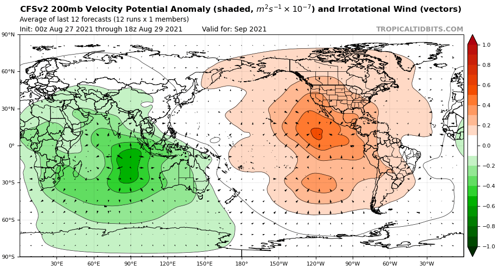
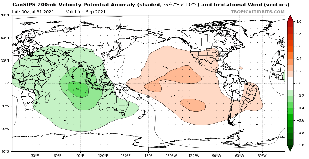
In my opinion, 2021 rivalling 2020 and 2005 is becoming increasingly more likely, and exhausting the main list seems like a certainty at this point. September 2021, unlike September 1995, seems very conducive for tropical cyclogenesis, and unlike 2020, there does not seem to be a lull of activity forecasted by either the CFS or ECMWF climate models. Without lulls of activity forecasted for September, September 2021 could beat September 2020 in storm count, hurricane count, and major hurricane count.
0 likes   

User avatar
Category5Kaiju
Category 5
Category 5
Posts: 4097
Joined: Thu Dec 24, 2020 12:45 pm
Location: Seattle

Re: 2021 Indicators: SST's / SAL / MSLP / Shear / Steering / Instability / Sat Images

#2910 Postby Category5Kaiju » Mon Aug 30, 2021 5:35 am

Chris90 wrote:
EquusStorm wrote:It's that time again to see where the pace of other seasons since 1995 would put us at the end of the year.

On August 29, we're remarkably already at 10 named storms. If this season continued at the pace of these past seasons, here's where we would wind up in named storms based on how many storms developed on or after August 29 of these years plus the ten we've already had. Subtract ten for the number of named storms that season had or after Aug 29.

A reminder - we have never gotten more than 16 named storms (Peter) on this list, and only been past 11 storms (Kate) one time ever, in 2003.

1995 - 17 (Rose)
1996 - 16 (Peter)
1997 - 13 (Mindy)
1998 - 20 (Victor)
1999 - 17 (Rose)
2000 - 21 (Wanda)
2001 - 21 (Wanda)
2002 - 19 (Teresa)
2003 - 20 (Victor)
2004 - 17 (Rose)
2005 - 27 (Foster)
2006 - 14 (Nicholas)
2007 - 20 (Victor)
2008 - 19 (Teresa)
2009 - 15 (Odette)
2010 - 24 (Caridad)
2011 - 19 (Teresa)
2012 - 18 (Sam)
2013 - 18 (Sam)
2014 - 15 (Odette)
2015 - 16 (Peter)
2016 - 18 (Sam)
2017 - 19 (Teresa)
2018 - 20 (Victor)
2019 - 23 (Braylen)
2020 - 27 (Foster)


What really sticks out to me is that even by 2019 pacing that would take us to the auxiliary list, and also 2018 pacing takes us to Victor. I was very skeptical of us exhausting the list again right after doing it last year, but this puts things in perspective and it seems much more achievable if we keep going how we have so far. I highly doubt we match 2005 and 2020 pacing to reach Foster, but getting to Braylen or Caridad seems like a very real possibility.


What would be even crazier to see this year is an auxiliary list named hurricane need its name retired. The prior consensus in 2006 was that getting more than 21 NSs in a season was very rare, but little did we know 2020 would manage to do that, with the season after that threatening to do the same. I think the WMO absolutely made the right call to use auxiliary names and not Greek letters to name extra storms.
0 likes   
Unless explicitly stated, all info in my posts is based on my own opinions and observations. Tropical storms and hurricanes can be extremely dangerous. Do not think you can beat Mother Nature. Refer to an accredited weather research agency or meteorologist if you need to make serious decisions regarding an approaching storm.

User avatar
aspen
Category 5
Category 5
Posts: 8818
Joined: Sat Oct 12, 2019 7:10 pm
Location: Connecticut, USA

Re: 2021 Indicators: SST's / SAL / MSLP / Shear / Steering / Instability / Sat Images

#2911 Postby aspen » Mon Aug 30, 2021 5:58 am

Teban54 wrote:While many storms this season have exceeded expectations, I would say Henri and Julian underperformed to some degrees. Both the NHC and earlier models insisted Henri would become a strong Cat 1 or a Cat 2; models also had Julian developing earlier and peaking stronger than it actually did, with some making it a powerful hurricane in the subtropics (although achieving 50 knots half a day after being named is certainly not struggling).

Maybe this is a one-off thing, but I wonder if this could be an indication that models are overdoing activity in the subtropics just like they have for the EPac. If that's the case, it might mean that deep tropics will be the hotspot even more than models suggest.

Henri suffered from typical HWRF bias. However, Julian was overhyped by all of the models, but it failed to develop until the last minute. Kind of like how Gabrielle ‘19 was modeled to be a lot stronger but struggled and stayed as just a moderate TS.
0 likes   
Irene '11 Sandy '12 Hermine '16 5/15/2018 Derecho Fay '20 Isaias '20 Elsa '21 Henri '21 Ida '21

I am only a meteorology enthusiast who knows a decent amount about tropical cyclones. Look to the professional mets, the NHC, or your local weather office for the best information.

User avatar
SFLcane
S2K Supporter
S2K Supporter
Posts: 10163
Age: 47
Joined: Sat Jun 05, 2010 1:44 pm
Location: Lake Worth Florida

Re: 2021 Indicators: SST's / SAL / MSLP / Shear / Steering / Instability / Sat Images

#2912 Postby SFLcane » Mon Aug 30, 2021 6:31 am

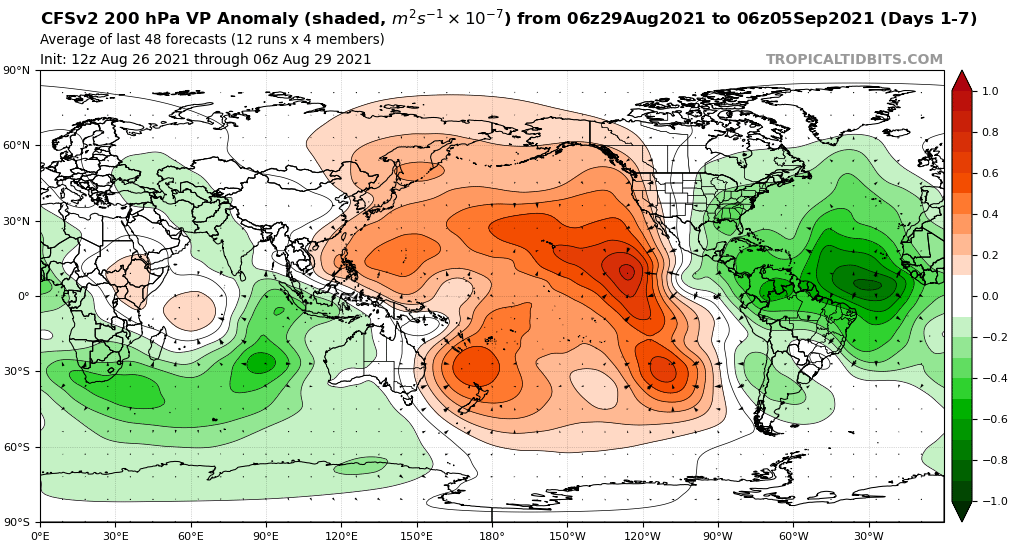
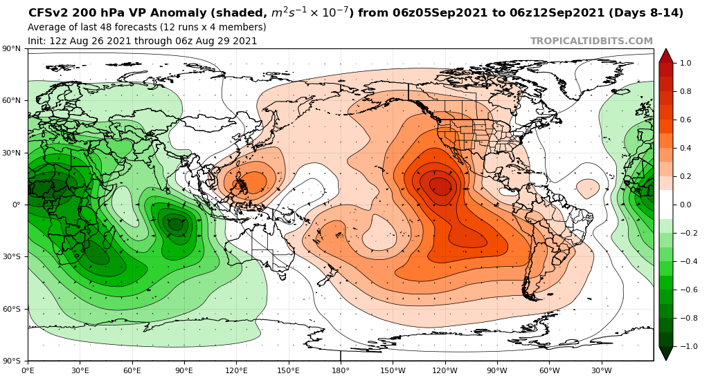
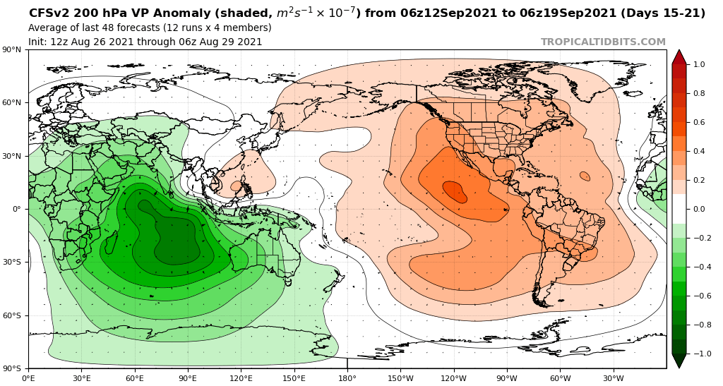
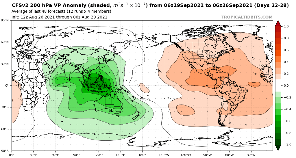
Models are just playing catch up the large-scale signal at peak is just too much to think there won't be more.

 https://twitter.com/andyhazelton/status/1432290721457901572


0 likes   

AlphaToOmega
Category 5
Category 5
Posts: 1448
Joined: Sat Jun 26, 2021 10:51 am
Location: Somewhere in Massachusetts

Re: 2021 Indicators: SST's / SAL / MSLP / Shear / Steering / Instability / Sat Images

#2913 Postby AlphaToOmega » Mon Aug 30, 2021 7:47 am

Image
Image
Image
Image
Image
Image
0 likes   


User avatar
Category5Kaiju
Category 5
Category 5
Posts: 4097
Joined: Thu Dec 24, 2020 12:45 pm
Location: Seattle

Re: 2021 Indicators: SST's / SAL / MSLP / Shear / Steering / Instability / Sat Images

#2915 Postby Category5Kaiju » Mon Aug 30, 2021 7:57 am


With how the Atlantic has been behaving so far and with the predictions of an EPAC rising cell no longer as prevalent, this could very well mean a hyperactive Atlantic in the end.
1 likes   
Unless explicitly stated, all info in my posts is based on my own opinions and observations. Tropical storms and hurricanes can be extremely dangerous. Do not think you can beat Mother Nature. Refer to an accredited weather research agency or meteorologist if you need to make serious decisions regarding an approaching storm.

User avatar
Category5Kaiju
Category 5
Category 5
Posts: 4097
Joined: Thu Dec 24, 2020 12:45 pm
Location: Seattle

Re: 2021 Indicators: SST's / SAL / MSLP / Shear / Steering / Instability / Sat Images

#2916 Postby Category5Kaiju » Mon Aug 30, 2021 8:52 am

Kate has been named, and the MDR has a very high chance of seeing Larry very soon. Then we have the Caribbean system, which could very well be Mindy or Nicholas (in the event some pop up storm steals the name Mindy). This imho is going to be a season with at least 20 NSs, and I have personally raised my prediction probability of reaching the auxiliary naming list.
0 likes   
Unless explicitly stated, all info in my posts is based on my own opinions and observations. Tropical storms and hurricanes can be extremely dangerous. Do not think you can beat Mother Nature. Refer to an accredited weather research agency or meteorologist if you need to make serious decisions regarding an approaching storm.

tolakram
Admin
Admin
Posts: 20009
Age: 62
Joined: Sun Aug 27, 2006 8:23 pm
Location: Florence, KY (name is Mark)

Re: 2021 Indicators: SST's / SAL / MSLP / Shear / Steering / Instability / Sat Images

#2917 Postby tolakram » Mon Aug 30, 2021 9:05 am

Kate, which is currently a naked swirl, is a good example of a storm that should be named, given technology we have today, but certainly would have not been named years ago. This underscores how we need a more solid metric for judging seasonal activity. ACE is better, but still flawed.

Now the future of Kate might be a solid tropical storm, or more, but the timing of the naming in this case is interesting as far as seasonal activity counting goes. :)
4 likes   
M a r k
- - - - -
Join us in chat: Storm2K Chatroom Invite. Android and IOS apps also available.

The posts in this forum are NOT official forecasts and should not be used as such. Posts are NOT endorsed by any professional institution or STORM2K.org. For official information and forecasts, please refer to NHC and NWS products.

User avatar
SFLcane
S2K Supporter
S2K Supporter
Posts: 10163
Age: 47
Joined: Sat Jun 05, 2010 1:44 pm
Location: Lake Worth Florida

Re: 2021 Indicators: SST's / SAL / MSLP / Shear / Steering / Instability / Sat Images

#2918 Postby SFLcane » Mon Aug 30, 2021 9:57 am

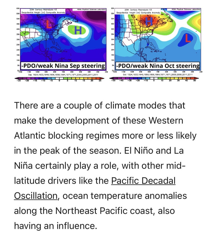
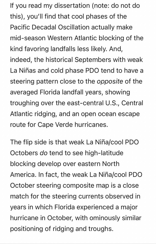
This is why I have real concerns for Florida late September especially into October. Vía @wx_tiger on Twitter.

Image

Image
1 likes   

User avatar
SFLcane
S2K Supporter
S2K Supporter
Posts: 10163
Age: 47
Joined: Sat Jun 05, 2010 1:44 pm
Location: Lake Worth Florida

Re: 2021 Indicators: SST's / SAL / MSLP / Shear / Steering / Instability / Sat Images

#2919 Postby SFLcane » Mon Aug 30, 2021 10:08 am

Just noticed he was spot on with (Open ocean excape route for hurricanes) wow but on the contrary bad news for Florida.
0 likes   

SconnieCane
Category 4
Category 4
Posts: 998
Joined: Thu Aug 02, 2018 5:29 pm
Location: Madison, WI

Re: 2021 Indicators: SST's / SAL / MSLP / Shear / Steering / Instability / Sat Images

#2920 Postby SconnieCane » Mon Aug 30, 2021 10:12 am

SFLcane wrote:This is why I have real concerns for Florida late September especially into October. Vía @wx_tiger on Twitter.

https://i.postimg.cc/9fBJNqrF/4-C3-E5-E8-C-6251-4-DC0-837-A-136-ADD023455.jpg

https://i.postimg.cc/q7r1LGB5/3-AA3-B670-3-F37-4975-85-D3-EB3-B1293-E600.jpg


We had concerns about this last October due to a similar teleconnection setup, where a system gets yeeted out of the Caribbean and hits the west coast of peninsular Florida, on a Charley or Wilma-type track. That sort of happened with Eta, but in a much weakened state after its CA landfall. Iota never made it out of there, and we had Delta and Zeta add insult to Laura's injury for Louisiana (little did we know what Ida had in store).

Kinda unnerving that we're give Ma Nature another turn at the plate with this setup...
1 likes   


Return to “Talkin' Tropics”

Who is online

Users browsing this forum: johngaltfla and 47 guests