2021 Indicators: SST's / SAL / MSLP / Shear / Steering / Instability / Sat Images

This is the general tropical discussion area. Anyone can take their shot at predicting a storms path.

Moderator: S2k Moderators

Forum rules

The posts in this forum are NOT official forecasts and should not be used as such. They are just the opinion of the poster and may or may not be backed by sound meteorological data. They are NOT endorsed by any professional institution or STORM2K. For official information, please refer to products from the National Hurricane Center and National Weather Service.

Help Support Storm2K
Message
Author
AlphaToOmega
Category 5
Category 5
Posts: 1448
Joined: Sat Jun 26, 2021 10:51 am
Location: Somewhere in Massachusetts

Re: 2021 Indicators: SST's / SAL / MSLP / Shear / Steering / Instability / Sat Images

#2941 Postby AlphaToOmega » Tue Aug 31, 2021 10:59 am

aspen wrote:

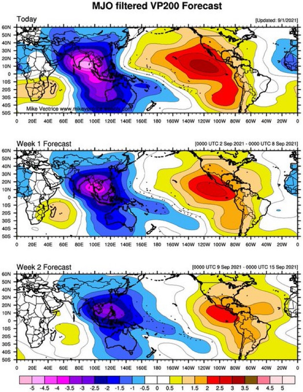
That would explain why the GFS isn’t showing anything after Larry. We’ll have to focus on the Euro, CMC, and EPS ensembles for possible TCG; all have done great with Larry, and the ensembles suggest we could see another MDR system next week.

Another possible limiting factor for anything outside of the Gulf or WCar is that SSTs aren’t as warm as 2017 or 2020 were at this time. The eastern and central Caribbean are surprisingly “cool” for this time of year — they aren’t unfavorable, but it’s surprising to see most of the Caribbean lacking 29C SSTs. The MDR will probably get a bit of a warm-up as the heat from the Atlantic Niño shifts north.


It is probably the cold wake from Hurricane Ida.
0 likes   

User avatar
SFLcane
S2K Supporter
S2K Supporter
Posts: 10163
Age: 47
Joined: Sat Jun 05, 2010 1:44 pm
Location: Lake Worth Florida

Re: 2021 Indicators: SST's / SAL / MSLP / Shear / Steering / Instability / Sat Images

#2942 Postby SFLcane » Tue Aug 31, 2021 11:01 am

Watch the Caribbean late September especially into October! :eek:

 https://twitter.com/philklotzbach/status/1432729905913946116


1 likes   

IcyTundra
Category 5
Category 5
Posts: 1205
Joined: Mon Jun 07, 2021 9:32 pm
Location: Dickinson, Texas

Re: 2021 Indicators: SST's / SAL / MSLP / Shear / Steering / Instability / Sat Images

#2943 Postby IcyTundra » Tue Aug 31, 2021 12:15 pm

2 likes   

User avatar
WiscoWx02
Category 1
Category 1
Posts: 391
Joined: Sat Jul 31, 2021 8:09 pm

Re: 2021 Indicators: SST's / SAL / MSLP / Shear / Steering / Instability / Sat Images

#2944 Postby WiscoWx02 » Tue Aug 31, 2021 4:07 pm

Image

The +AMO has returned, not that it was ever truly gone but it now looks fully engraved into the SSTA pattern. Seems to be the story of the last 4 years, with it making its full reappearance in August/September :lol:
10 likes   

User avatar
abajan
S2K Supporter
S2K Supporter
Posts: 4232
Joined: Sun Sep 07, 2003 5:10 am
Location: Barbados

Re: 2021 Indicators: SST's / SAL / MSLP / Shear / Steering / Instability / Sat Images

#2945 Postby abajan » Tue Aug 31, 2021 6:14 pm

[youtube]https://youtu.be/MPWd0kL4y6A[/youtube]
0 likes   

User avatar
Category5Kaiju
Category 5
Category 5
Posts: 4097
Joined: Thu Dec 24, 2020 12:45 pm
Location: Seattle

Re: 2021 Indicators: SST's / SAL / MSLP / Shear / Steering / Instability / Sat Images

#2946 Postby Category5Kaiju » Tue Aug 31, 2021 6:46 pm

WiscoWx02 wrote:https://coralreefwatch.noaa.gov/data_current/5km/v3.1_op/daily/png/ct5km_ssta_v3.1_west_current.png

The +AMO has returned, not that it was ever truly gone but it now looks fully engraved into the SSTA pattern. Seems to be the story of the last 4 years, with it making its full reappearance in August/September :lol:


Those "cool MDR will make season inactive" comments earlier in May have aged like milk, I see.
9 likes   
Unless explicitly stated, all info in my posts is based on my own opinions and observations. Tropical storms and hurricanes can be extremely dangerous. Do not think you can beat Mother Nature. Refer to an accredited weather research agency or meteorologist if you need to make serious decisions regarding an approaching storm.

AlphaToOmega
Category 5
Category 5
Posts: 1448
Joined: Sat Jun 26, 2021 10:51 am
Location: Somewhere in Massachusetts

Re: 2021 Indicators: SST's / SAL / MSLP / Shear / Steering / Instability / Sat Images

#2947 Postby AlphaToOmega » Wed Sep 01, 2021 5:17 am

The ECMWF shows us going into Phase IV by September 20. Phase IV is the most favorable phase for Atlantic tropical cyclogenesis.
0 likes   

User avatar
kevin
Category 5
Category 5
Posts: 2586
Age: 26
Joined: Wed Aug 28, 2019 4:35 am

Re: 2021 Indicators: SST's / SAL / MSLP / Shear / Steering / Instability / Sat Images

#2948 Postby kevin » Wed Sep 01, 2021 5:27 am

Since there is a pretty good chance 2021 will also become an above average season, that would mean that we would have 6 above average (solely using the +126.1 ACE indicator) seasons in a row. That is the longest streak of active seasons since the records started in 1851. Here's an overview of the longest above average streaks. Note that this is thus only based on ACE, not the number of named storms.

Streak length - Years

5 = 2016/2017/2018/2019/2020 (and thus possibly including 2021)
3 = 2010/2011/2012, 2003/2004/2005
2 = 1998/1999, 1995/1996, 1950/1951, 1932/1933, 1915/1916, 1893/1994, 1886/1887
6 likes   

User avatar
Category5Kaiju
Category 5
Category 5
Posts: 4097
Joined: Thu Dec 24, 2020 12:45 pm
Location: Seattle

Re: 2021 Indicators: SST's / SAL / MSLP / Shear / Steering / Instability / Sat Images

#2949 Postby Category5Kaiju » Wed Sep 01, 2021 5:53 am

I think another poster mentioned something like this earlier in this thread, but seeing at least 5 NSs in the month of September should be expected, as recent years have shown. With that being said, we could conceivably see Mindy, Nicholas, Odette, and Peter after Larry all in September, which would only leave us with 5 standard names for the rest of the season. Given a La Niña is expected to occur, I feel like seeing just 5 NSs in October and November is a bit small.
1 likes   
Unless explicitly stated, all info in my posts is based on my own opinions and observations. Tropical storms and hurricanes can be extremely dangerous. Do not think you can beat Mother Nature. Refer to an accredited weather research agency or meteorologist if you need to make serious decisions regarding an approaching storm.

AlphaToOmega
Category 5
Category 5
Posts: 1448
Joined: Sat Jun 26, 2021 10:51 am
Location: Somewhere in Massachusetts

Re: 2021 Indicators: SST's / SAL / MSLP / Shear / Steering / Instability / Sat Images

#2950 Postby AlphaToOmega » Wed Sep 01, 2021 6:19 am

Category5Kaiju wrote:I think another poster mentioned something like this earlier in this thread, but seeing at least 5 NSs in the month of September should be expected, as recent years have shown. With that being said, we could conceivably see Mindy, Nicholas, Odette, and Peter after Larry all in September, which would only leave us with 5 standard names for the rest of the season. Given a La Niña is expected to occur, I feel like seeing just 5 NSs in October and November is a bit small.

The most recent Septembers have been very active. I believe we could see at least seven storms in September, and that is supported by the favorable VP patterns forecasted for all of September. The GFS and GEFS ensembles show multiple tropical waves coming off Africa that could develop into tropical cyclones. They also show potential subtropical development off the East Coast, not to mention Invest 91L.
1 likes   

User avatar
SFLcane
S2K Supporter
S2K Supporter
Posts: 10163
Age: 47
Joined: Sat Jun 05, 2010 1:44 pm
Location: Lake Worth Florida

Re: 2021 Indicators: SST's / SAL / MSLP / Shear / Steering / Instability / Sat Images

#2951 Postby SFLcane » Wed Sep 01, 2021 8:26 am

Here’s your reason why the models go quite after Larry. suppressed MJO state coming in. Will fight climo

What it ultimately means for the rest of the season who knows

Image
1 likes   

AlphaToOmega
Category 5
Category 5
Posts: 1448
Joined: Sat Jun 26, 2021 10:51 am
Location: Somewhere in Massachusetts

Re: 2021 Indicators: SST's / SAL / MSLP / Shear / Steering / Instability / Sat Images

#2952 Postby AlphaToOmega » Wed Sep 01, 2021 8:28 am

SFLcane wrote:Here’s your reason why the models go quite after Larry. suppressed MJO state coming in. Will fight climo

What it ultimately means for the rest of the season who knows

https://i.postimg.cc/nczT1q5F/A153-BECC-EFE6-44-C6-94-DB-1-AA8-BCB57882.jpg


What model is that?
0 likes   

AutoPenalti
Category 5
Category 5
Posts: 4030
Age: 29
Joined: Mon Aug 17, 2015 4:16 pm
Location: Ft. Lauderdale, Florida

Re: 2021 Indicators: SST's / SAL / MSLP / Shear / Steering / Instability / Sat Images

#2953 Postby AutoPenalti » Wed Sep 01, 2021 8:28 am

SFLcane wrote:Here’s your reason why the models go quite after Larry. suppressed MJO state coming in. Will fight climo

What it ultimately means for the rest of the season who knows

https://i.postimg.cc/nczT1q5F/A153-BECC-EFE6-44-C6-94-DB-1-AA8-BCB57882.jpg

Were we just not discussing the upcoming MJO going through phase 4?
Last edited by AutoPenalti on Wed Sep 01, 2021 8:29 am, edited 1 time in total.
1 likes   
The posts in this forum are NOT official forecasts and should not be used as such. They are just the opinion of the poster and may or may not be backed by sound meteorological data. They are NOT endorsed by any professional institution or STORM2K. For official information, please refer to products from the NHC and NWS.


Model Runs Cheat Sheet:
GFS (5:30 AM/PM, 11:30 AM/PM)
HWRF, GFDL, UKMET, NAVGEM (6:30-8:00 AM/PM, 12:30-2:00 AM/PM)
ECMWF (1:45 AM/PM)

TCVN
is a weighted averaged

User avatar
aspen
Category 5
Category 5
Posts: 8818
Joined: Sat Oct 12, 2019 7:10 pm
Location: Connecticut, USA

Re: 2021 Indicators: SST's / SAL / MSLP / Shear / Steering / Instability / Sat Images

#2954 Postby aspen » Wed Sep 01, 2021 8:28 am

SFLcane wrote:Here’s your reason why the models go quite after Larry. suppressed MJO state coming in. Will fight climo

What it ultimately means for the rest of the season who knows

https://i.postimg.cc/nczT1q5F/A153-BECC-EFE6-44-C6-94-DB-1-AA8-BCB57882.jpg

I thought the MJO was going into Phase 4, which is still favorable for the Atlantic.
0 likes   
Irene '11 Sandy '12 Hermine '16 5/15/2018 Derecho Fay '20 Isaias '20 Elsa '21 Henri '21 Ida '21

I am only a meteorology enthusiast who knows a decent amount about tropical cyclones. Look to the professional mets, the NHC, or your local weather office for the best information.

AlphaToOmega
Category 5
Category 5
Posts: 1448
Joined: Sat Jun 26, 2021 10:51 am
Location: Somewhere in Massachusetts

Re: 2021 Indicators: SST's / SAL / MSLP / Shear / Steering / Instability / Sat Images

#2955 Postby AlphaToOmega » Wed Sep 01, 2021 8:38 am

SFLcane wrote:Here’s your reason why the models go quite after Larry. suppressed MJO state coming in. Will fight climo

What it ultimately means for the rest of the season who knows

https://i.postimg.cc/nczT1q5F/A153-BECC-EFE6-44-C6-94-DB-1-AA8-BCB57882.jpg


That looks pretty unrealistic, especially for a +AMO year such as 2021. West Africa is typically supposed to experience -VP anomalies in such years. The CMC also shows two tropical waves that could develop into tropical storms within the next 10 days.
0 likes   

User avatar
Category5Kaiju
Category 5
Category 5
Posts: 4097
Joined: Thu Dec 24, 2020 12:45 pm
Location: Seattle

Re: 2021 Indicators: SST's / SAL / MSLP / Shear / Steering / Instability / Sat Images

#2956 Postby Category5Kaiju » Wed Sep 01, 2021 8:41 am

SFLcane wrote:Here’s your reason why the models go quite after Larry. suppressed MJO state coming in. Will fight climo

What it ultimately means for the rest of the season who knows

https://i.postimg.cc/nczT1q5F/A153-BECC-EFE6-44-C6-94-DB-1-AA8-BCB57882.jpg


What the heck? That pattern completely disobeys our common understanding of climo and why La Ninas favor late season activity. Not to mention during September doesn't MJO progression (especially suppressive) not really matter? Either way, I find it somewhat strange and incredible that we would not be able to see much activity in peak month September after Larry, it hardly makes any relative sense.
0 likes   
Unless explicitly stated, all info in my posts is based on my own opinions and observations. Tropical storms and hurricanes can be extremely dangerous. Do not think you can beat Mother Nature. Refer to an accredited weather research agency or meteorologist if you need to make serious decisions regarding an approaching storm.

AlphaToOmega
Category 5
Category 5
Posts: 1448
Joined: Sat Jun 26, 2021 10:51 am
Location: Somewhere in Massachusetts

Re: 2021 Indicators: SST's / SAL / MSLP / Shear / Steering / Instability / Sat Images

#2957 Postby AlphaToOmega » Wed Sep 01, 2021 8:45 am

For reference, this is what the CanSIPS shows
Image
0 likes   

User avatar
WiscoWx02
Category 1
Category 1
Posts: 391
Joined: Sat Jul 31, 2021 8:09 pm

Re: 2021 Indicators: SST's / SAL / MSLP / Shear / Steering / Instability / Sat Images

#2958 Postby WiscoWx02 » Wed Sep 01, 2021 8:49 am

Category5Kaiju wrote:
SFLcane wrote:Here’s your reason why the models go quite after Larry. suppressed MJO state coming in. Will fight climo

What it ultimately means for the rest of the season who knows

https://i.postimg.cc/nczT1q5F/A153-BECC-EFE6-44-C6-94-DB-1-AA8-BCB57882.jpg


What the heck? That pattern completely disobeys our common understanding of climo and why La Ninas favor late season activity. Not to mention during September doesn't MJO progression (especially suppressive) not really matter? Either way, I find it somewhat strange and incredible that we would not be able to see much activity in peak month September after Larry, it hardly makes any relative sense.


I agree, I highly....HIGHLY doubt this will end up verifying and if it does....well that's just lucky. It's very hard to have nothing in September even when the background state isn't as favorable. Even in quite years like 2015, 2009, heck, even 2013, September was the most active part of the season. I think we will see a slow correction again with how the models propagate the MJO. Null phase for a while at least before coming back into the Atlantic, Africa and Indian Ocean.
0 likes   

AutoPenalti
Category 5
Category 5
Posts: 4030
Age: 29
Joined: Mon Aug 17, 2015 4:16 pm
Location: Ft. Lauderdale, Florida

Re: 2021 Indicators: SST's / SAL / MSLP / Shear / Steering / Instability / Sat Images

#2959 Postby AutoPenalti » Wed Sep 01, 2021 8:53 am

AlphaToOmega wrote:For reference, this is what the CanSIPS shows
https://i.postimg.cc/5NN4BvC0/cansips-chi200-global-1.png

It suppresses EPAC activity for sure.
0 likes   
The posts in this forum are NOT official forecasts and should not be used as such. They are just the opinion of the poster and may or may not be backed by sound meteorological data. They are NOT endorsed by any professional institution or STORM2K. For official information, please refer to products from the NHC and NWS.


Model Runs Cheat Sheet:
GFS (5:30 AM/PM, 11:30 AM/PM)
HWRF, GFDL, UKMET, NAVGEM (6:30-8:00 AM/PM, 12:30-2:00 AM/PM)
ECMWF (1:45 AM/PM)

TCVN
is a weighted averaged

User avatar
WiscoWx02
Category 1
Category 1
Posts: 391
Joined: Sat Jul 31, 2021 8:09 pm

Re: 2021 Indicators: SST's / SAL / MSLP / Shear / Steering / Instability / Sat Images

#2960 Postby WiscoWx02 » Wed Sep 01, 2021 9:09 am

AutoPenalti wrote:
AlphaToOmega wrote:For reference, this is what the CanSIPS shows
https://i.postimg.cc/5NN4BvC0/cansips-chi200-global-1.png

It suppresses EPAC activity for sure.


That's about as favorable of a signal as you can get :eek:
0 likes   


Return to “Talkin' Tropics”

Who is online

Users browsing this forum: dl20415 and 44 guests