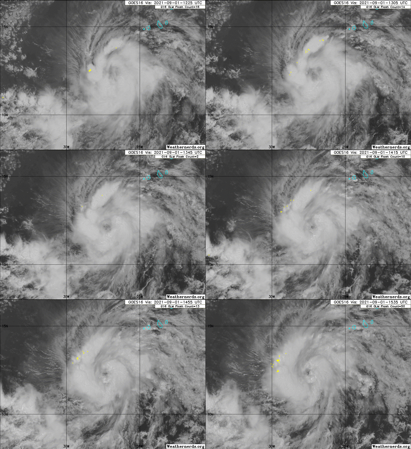
ATL: LARRY - Post-Tropical - Discussion

Moderator: S2k Moderators

Message
Author
TheBigO
Tropical Low
Tropical Low
Posts: 35
Joined: Wed Sep 06, 2017 9:39 pm
Location: Orlando, FL metro

Re: ATL: LARRY - Tropical Storm - Discussion

#161 Postby TheBigO » Wed Sep 01, 2021 9:33 am

gatorcane wrote:
TheBigO wrote:Correct me if I’m wrong here, but didn’t Irma start out a lot like this with similar early intensity and early recurve models?


I looked back at Irma models and they were much further west before recurving. The recurve signal is about as strong as it gets at the moment with Larry, thankfully.


Cool, thanks amigo. I’ll still keep a close eye on this one, just got a bad vibe, but fortunately since I don’t believe in magic I know the “bad vibe” is nothing more than just nerves. :P
0 likes   

User avatar
cycloneye
Admin
Admin
Posts: 143867
Age: 68
Joined: Thu Oct 10, 2002 10:54 am
Location: San Juan, Puerto Rico

Re: ATL: LARRY - Tropical Storm - Discussion

#162 Postby cycloneye » Wed Sep 01, 2021 9:58 am

Due to a more westerly initial
position, the guidance has shifted a little more to the west, and
the new forecast track is again shifted to the west of the previous
track. The new forecast lies a little to the south of the various
consensus models.
0 likes   
Visit the Caribbean-Central America Weather Thread where you can find at first post web cams,radars
and observations from Caribbean basin members Click Here

User avatar
vbhoutex
Storm2k Executive
Storm2k Executive
Posts: 29096
Age: 73
Joined: Wed Oct 09, 2002 11:31 pm
Location: Cypress, TX
Contact:

Re: ATL: LARRY - Tropical Storm - Discussion

#163 Postby vbhoutex » Wed Sep 01, 2021 10:10 am

TheBigO wrote:
gatorcane wrote:
TheBigO wrote:Correct me if I’m wrong here, but didn’t Irma start out a lot like this with similar early intensity and early recurve models?


I looked back at Irma models and they were much further west before recurving. The recurve signal is about as strong as it gets at the moment with Larry, thankfully.


Cool, thanks amigo. I’ll still keep a close eye on this one, just got a bad vibe, but fortunately since I don’t believe in magic I know the “bad vibe” is nothing more than just nerves. :P

Sometimes our nerves tell us things we need to listen to. So far all seems to point to Larry staying well away from any US landfall BUT I'm also seeing some chatter from somewhat reliable sources saying "don't place your bets yet!". Or as I say NEVER SAY NEVER! And no I am not -removed- anything!!
3 likes   
Skywarn, C.E.R.T.
Please click below to donate to STORM2K to help with the expenses of keeping the site going:
Image

User avatar
kevin
Category 5
Category 5
Posts: 2554
Age: 26
Joined: Wed Aug 28, 2019 4:35 am

Re: ATL: LARRY - Tropical Storm - Discussion

#164 Postby kevin » Wed Sep 01, 2021 10:12 am

This beautiful color party is my attempt to overlay the NHC forecast on top of the MPI map. They use slightly different map projections so it'll never be precisely the same, but hopefully this gives an indication of Larry's future. Larry will be in high (cat 4) MPIs until Friday when he will spend about 24 - 48 hrs in lower (cat 3) MPIs. If Larry wants to intensify, these MPIs aren't sufficient to stop Larry from becoming a MH, but this should at least prevent Larry from immediately bombing to a cat 4 or something like that. However, around Sunday Larry will enter the cat 4 MPIs again and that's probably when it'll intensify further. However, one very important note to make is that just south of Larry's forecast, hurricane potential is way higher. If Larry tracks just 2 degrees south of its current forecast it could remain in cat 4 MPIs and even reach cat 5 waters. So basically, the further south Larry goes the stronger he'll probably get.

Image
9 likes   

AutoPenalti
Category 5
Category 5
Posts: 4029
Age: 28
Joined: Mon Aug 17, 2015 4:16 pm
Location: Ft. Lauderdale, Florida

Re: ATL: LARRY - Tropical Storm - Discussion

#165 Postby AutoPenalti » Wed Sep 01, 2021 10:16 am

Seems to be a lot is riding on:

A) How strong the the CATL ridge is as Kate moves away
B) Influences on now ex-Tropical Ida creating an avenue closer to the coast
C) Current movement of Larry as it travels near 12N. NHC has this forecasted to move across 15N by Friday night.

Mark Sudduth talked about this scenario in his outlook discussion yesterday, he mentioned that the farther this gets to the west, the higher probability that this misses the weakness in the CATL and moves underneath the strengthening Bermuda ridge. As it looks like the ridge is fragmented into two pieces which is likely creating that avenue at 55W.
1 likes   
The posts in this forum are NOT official forecasts and should not be used as such. They are just the opinion of the poster and may or may not be backed by sound meteorological data. They are NOT endorsed by any professional institution or STORM2K. For official information, please refer to products from the NHC and NWS.


Model Runs Cheat Sheet:
GFS (5:30 AM/PM, 11:30 AM/PM)
HWRF, GFDL, UKMET, NAVGEM (6:30-8:00 AM/PM, 12:30-2:00 AM/PM)
ECMWF (1:45 AM/PM)

TCVN
is a weighted averaged

User avatar
Iceresistance
Category 5
Category 5
Posts: 9279
Age: 21
Joined: Sat Oct 10, 2020 9:45 am
Location: Tecumseh, OK/Norman, OK

Re: ATL: LARRY - Tropical Storm - Discussion

#166 Postby Iceresistance » Wed Sep 01, 2021 10:25 am

vbhoutex wrote:
TheBigO wrote:
gatorcane wrote:
I looked back at Irma models and they were much further west before recurving. The recurve signal is about as strong as it gets at the moment with Larry, thankfully.


Cool, thanks amigo. I’ll still keep a close eye on this one, just got a bad vibe, but fortunately since I don’t believe in magic I know the “bad vibe” is nothing more than just nerves. :P

Sometimes our nerves tell us things we need to listen to. So far all seems to point to Larry staying well away from any US landfall BUT I'm also seeing some chatter from somewhat reliable sources saying "don't place your bets yet!". Or as I say NEVER SAY NEVER! And no I am not -removed- anything!!


With Kate weaker, there is a higher chance that Larry will not be OTS storm since Kate would have weakened the ridge to where Larry can curve OTS, if Larry slows down or even curves in a southerly direction, it will allow the Bermuda ridge to build & force Larry into either the Lesser Antilles, The Bahamas, or the East Coast.

(I really hope that Larry goes OTS, and not pull an Irma or Florence since the models also underestimated the ridge with those 2 storms)
0 likes   
Bill 2015 & Beta 2020

Winter 2020-2021 :cold:

All observations are in Tecumseh, OK unless otherwise noted.

Winter posts are focused mainly for Oklahoma & Texas.

Take any of my forecasts with a grain of salt, refer to the NWS, SPC, and NHC for official information

Never say Never with weather! Because ANYTHING is possible!

User avatar
Jr0d
S2K Supporter
S2K Supporter
Posts: 1394
Joined: Tue Aug 27, 2019 10:52 am
Location: Cayo Hueso

Re: ATL: LARRY - Tropical Storm - Discussion

#167 Postby Jr0d » Wed Sep 01, 2021 10:26 am

The Pacific had 2 annular hurricanes this season, looks like Larry has a good chance of going annular also.

The latest ICON is further west. Bermuda and Canada néed to watch this one.
0 likes   

tolakram
Admin
Admin
Posts: 19990
Age: 61
Joined: Sun Aug 27, 2006 8:23 pm
Location: Florence, KY (name is Mark)

Re: ATL: LARRY - Tropical Storm - Discussion

#168 Postby tolakram » Wed Sep 01, 2021 10:27 am

TheBigO wrote:Correct me if I’m wrong here, but didn’t Irma start out a lot like this with similar early intensity and early recurve models?


Initial Irma models and the NHC forecast had Irma moving south of west for a while.
0 likes   
M a r k
- - - - -
Join us in chat: Storm2K Chatroom Invite. Android and IOS apps also available.

The posts in this forum are NOT official forecasts and should not be used as such. Posts are NOT endorsed by any professional institution or STORM2K.org. For official information and forecasts, please refer to NHC and NWS products.

User avatar
Blown Away
S2K Supporter
S2K Supporter
Posts: 10140
Joined: Wed May 26, 2004 6:17 am

Re: ATL: LARRY - Tropical Storm - Discussion

#169 Postby Blown Away » Wed Sep 01, 2021 10:43 am

Not seeing any hints of a turn W after day 5 in the models or ensembles. NHC just keeps the day 3-5 NW turn farther W. A few more shifts maybe a NE Caribbean or Bermuda issue. No hints of CONUS potential yet.
0 likes   
Hurricane Eye Experience: David 79, Irene 99, Frances 04, Jeanne 04, Wilma 05... EYE COMING MY WAY IN 2024…
Hurricane Brush Experience: Andrew 92, Erin 95, Floyd 99, Matthew 16, Irma 17, Ian 22, Nicole 22…

grapealcoholic
Category 2
Category 2
Posts: 684
Joined: Tue Aug 10, 2021 3:26 pm

Re: ATL: LARRY - Tropical Storm - Discussion

#170 Postby grapealcoholic » Wed Sep 01, 2021 10:44 am

Eye warming
0 likes   

User avatar
cheezyWXguy
Category 5
Category 5
Posts: 6091
Joined: Mon Feb 13, 2006 12:29 am
Location: Dallas, TX

Re: ATL: LARRY - Tropical Storm - Discussion

#171 Postby cheezyWXguy » Wed Sep 01, 2021 10:51 am

Wow, this storm is coming together fast.
0 likes   

Sciencerocks
Category 5
Category 5
Posts: 8903
Age: 39
Joined: Thu Jul 06, 2017 1:51 am

Re: ATL: LARRY - Tropical Storm - Discussion

#172 Postby Sciencerocks » Wed Sep 01, 2021 10:55 am

Image
6 likes   

tolakram
Admin
Admin
Posts: 19990
Age: 61
Joined: Sun Aug 27, 2006 8:23 pm
Location: Florence, KY (name is Mark)

Re: ATL: LARRY - Tropical Storm - Discussion

#173 Postby tolakram » Wed Sep 01, 2021 10:56 am

0 likes   
M a r k
- - - - -
Join us in chat: Storm2K Chatroom Invite. Android and IOS apps also available.

The posts in this forum are NOT official forecasts and should not be used as such. Posts are NOT endorsed by any professional institution or STORM2K.org. For official information and forecasts, please refer to NHC and NWS products.

User avatar
Blown Away
S2K Supporter
S2K Supporter
Posts: 10140
Joined: Wed May 26, 2004 6:17 am

Re: ATL: LARRY - Tropical Storm - Discussion

#174 Postby Blown Away » Wed Sep 01, 2021 11:05 am

cheezyWXguy wrote:Wow, this storm is coming together fast.


Amazing, you can almost see the makings of that large eye the models have been showing.
0 likes   
Hurricane Eye Experience: David 79, Irene 99, Frances 04, Jeanne 04, Wilma 05... EYE COMING MY WAY IN 2024…
Hurricane Brush Experience: Andrew 92, Erin 95, Floyd 99, Matthew 16, Irma 17, Ian 22, Nicole 22…

User avatar
SouthernBreeze
Category 1
Category 1
Posts: 284
Age: 68
Joined: Tue Aug 31, 2004 4:54 pm
Location: SC/NC line- on the SC Coast

Re: ATL: LARRY - Tropical Storm - Discussion

#175 Postby SouthernBreeze » Wed Sep 01, 2021 11:07 am

NHC showing a bit of northerly lift by tomorrow AM. I know its still way out there, but would be nice to see that begin to happen
0 likes   
My posts are NOT official forecast and should not be used as such. It's just my opinion and not backed by sound meteorological data, and NOT endorsed by any professional institution or storm2k.org. For official information, please refer to the NHC and NWS products.

grazed by many - most wind damage: Hugo (pre-cellphone days!) & most water: Floyd

User avatar
Kohlecane
Category 2
Category 2
Posts: 591
Age: 33
Joined: Sun Jul 31, 2011 11:03 pm
Location: Beaufort, SC

Re: ATL: LARRY - Tropical Storm - Discussion

#176 Postby Kohlecane » Wed Sep 01, 2021 11:25 am

seems like 15N/45W is going to be the mark to watch
3 likes   
Once I see the REDS and GREENS Converge on a Base Velocity. ... I'm There!!

This is NOT an Official Forecast....Just my Opinion. For official information, please refer to the NHC and NWS products.
HIGHLIGHTS : '13 El Reno Tornado : 2013 Storm Chaser Tour, Joaquin; SC flood event, Matthew '16, Lowcountry Snow storm Jan '18

User avatar
weeniepatrol
Category 5
Category 5
Posts: 1252
Joined: Sat Aug 22, 2020 5:30 pm
Location: WA State

Re: ATL: LARRY - Tropical Storm - Discussion

#177 Postby weeniepatrol » Wed Sep 01, 2021 11:41 am

lol :lol:

Last edited by weeniepatrol on Wed Sep 01, 2021 11:54 am, edited 1 time in total.
7 likes   

tolakram
Admin
Admin
Posts: 19990
Age: 61
Joined: Sun Aug 27, 2006 8:23 pm
Location: Florence, KY (name is Mark)

Re: ATL: LARRY - Tropical Storm - Discussion

#178 Postby tolakram » Wed Sep 01, 2021 11:49 am

Eye-like feature alert!
0 likes   
M a r k
- - - - -
Join us in chat: Storm2K Chatroom Invite. Android and IOS apps also available.

The posts in this forum are NOT official forecasts and should not be used as such. Posts are NOT endorsed by any professional institution or STORM2K.org. For official information and forecasts, please refer to NHC and NWS products.

User avatar
cycloneye
Admin
Admin
Posts: 143867
Age: 68
Joined: Thu Oct 10, 2002 10:54 am
Location: San Juan, Puerto Rico

Re: ATL: LARRY - Tropical Storm - Discussion

#179 Postby cycloneye » Wed Sep 01, 2021 11:52 am

tolakram wrote:Eye-like feature alert!


Some in twitterland say is a dry slot and other say eye.
1 likes   
Visit the Caribbean-Central America Weather Thread where you can find at first post web cams,radars
and observations from Caribbean basin members Click Here

User avatar
weeniepatrol
Category 5
Category 5
Posts: 1252
Joined: Sat Aug 22, 2020 5:30 pm
Location: WA State

Re: ATL: LARRY - Tropical Storm - Discussion

#180 Postby weeniepatrol » Wed Sep 01, 2021 11:55 am

It's definitely not an eye, but it would be nice so that its chances of recurving increase
1 likes   


Return to “2021”

Who is online

Users browsing this forum: No registered users and 28 guests