2021 Indicators: SST's / SAL / MSLP / Shear / Steering / Instability / Sat Images
Moderator: S2k Moderators
Forum rules

The posts in this forum are NOT official forecasts and should not be used as such. They are just the opinion of the poster and may or may not be backed by sound meteorological data. They are NOT endorsed by any professional institution or STORM2K. For official information, please refer to products from the National Hurricane Center and National Weather Service.
-
SFLcane

- S2K Supporter

- Posts: 10281
- Age: 48
- Joined: Sat Jun 05, 2010 1:44 pm
- Location: Lake Worth Florida
Re: 2021 Indicators: SST's / SAL / MSLP / Shear / Steering / Instability / Sat Images
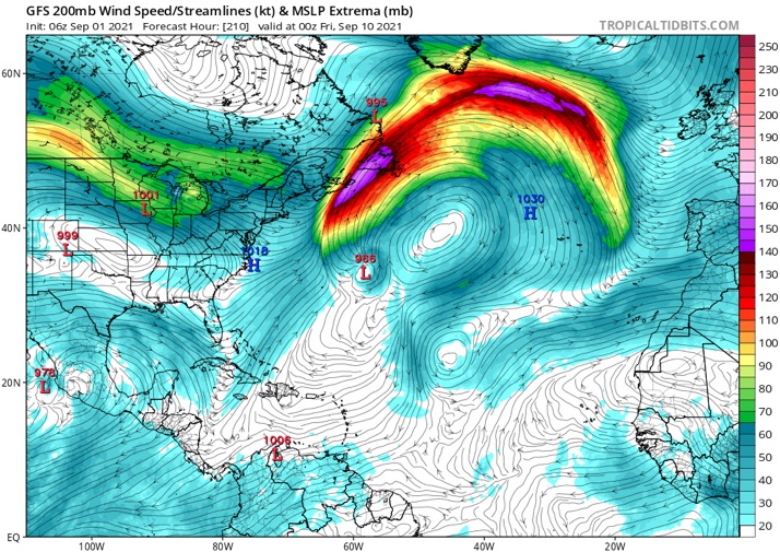
Larry is potentially going to alter the entire Atlantic as it recurves.
0 likes
-
AlphaToOmega
- Category 5

- Posts: 1448
- Joined: Sat Jun 26, 2021 10:51 am
- Location: Somewhere in Massachusetts
Re: 2021 Indicators: SST's / SAL / MSLP / Shear / Steering / Instability / Sat Images
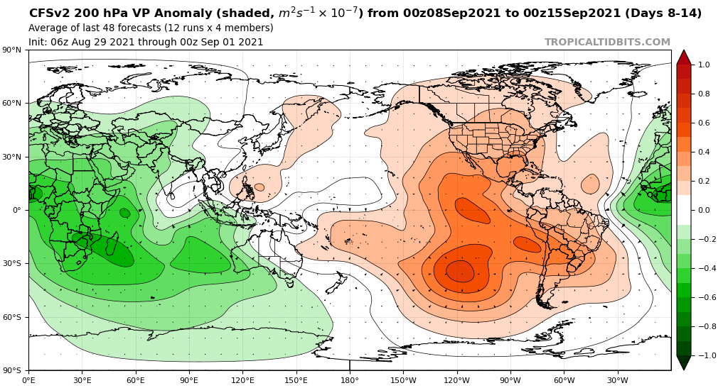
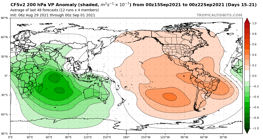
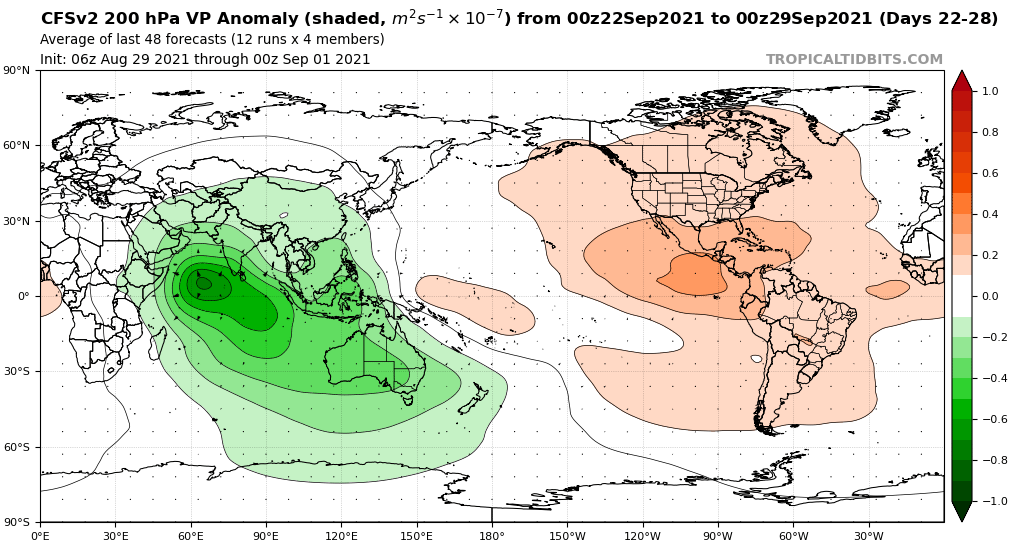
Even the CFSv2 knows September will be very active
0 likes
-
AlphaToOmega
- Category 5
- Posts: 1448
- Joined: Sat Jun 26, 2021 10:51 am
- Location: Somewhere in Massachusetts
Re: 2021 Indicators: SST's / SAL / MSLP / Shear / Steering / Instability / Sat Images
So far, none of the inhibiting factors people have discussed have come to fruition. 2021 was not plagued with TUTTs. 2021 does not have a below-average MDR. 2021 never had a negative AMO. The only factor that inhibited 2021 was Saharan dust, but that is a factor every year.
3 likes
-
AlphaToOmega
- Category 5
- Posts: 1448
- Joined: Sat Jun 26, 2021 10:51 am
- Location: Somewhere in Massachusetts
Re: 2021 Indicators: SST's / SAL / MSLP / Shear / Steering / Instability / Sat Images
Amplified Phase IV for peak season
Again, Phase IV is the most favorable phase of the MJO
Again, Phase IV is the most favorable phase of the MJO
0 likes
-
CyclonicFury

- Category 5
- Posts: 2035
- Age: 27
- Joined: Sun Jul 02, 2017 12:32 pm
- Location: NC
- Contact:
Re: 2021 Indicators: SST's / SAL / MSLP / Shear / Steering / Instability / Sat Images
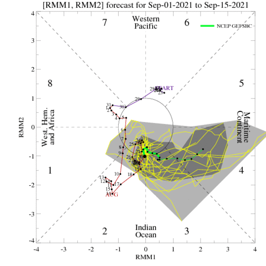
A suppressed KW is expected to cross the Atlantic in a week or so, which may limit new TC formations around that time. After that, we might see a weak CCKW pass the Atlantic again which could lead to another period of activity.
0 likes
NCSU B.S. in Meteorology Class of 2021. Tropical weather blogger at http://www.cyclonicfury.com. My forecasts and thoughts are NOT official, for official forecasts please consult the National Hurricane Center.
-
tolakram
- Admin

- Posts: 20186
- Age: 62
- Joined: Sun Aug 27, 2006 8:23 pm
- Location: Florence, KY (name is Mark)
Re: 2021 Indicators: SST's / SAL / MSLP / Shear / Steering / Instability / Sat Images
Shell Mound wrote:WiscoWx02 wrote:Shear has been the name of the game so far, perhaps because of the warmer than normal Nino 1+2 and subtropical Atlantic.
I think these two factors will combine to prevent a significant rise in strong activity during climatological the peak of the season. So far the MJO has not helped.
Nope, things changed very soon after the typical beginning of the season, Aug 20th. Now Larry has formed, is moving at 17mph, and developing rapidly. Thus the importance of never thinking current conditions will persist. Works both ways though, just because we've been active doesn't mean we will stay active. What this reinforces for me, though, is how poorly we can predict even a week in advance, much less 2 weeks.
8 likes
M a r k
- - - - -
Join us in chat: Storm2K Chatroom Invite. Android and IOS apps also available.
The posts in this forum are NOT official forecasts and should not be used as such. Posts are NOT endorsed by any professional institution or STORM2K.org. For official information and forecasts, please refer to NHC and NWS products.

Re: 2021 Indicators: SST's / SAL / MSLP / Shear / Steering / Instability / Sat Images
Two years ago today, Dorian became a 160 kt Cat 5 at landfall. It had become the first major a few days prior, so this got me thinking about how 2021 stacks up to other active seasons in terms of when their majors formed and how many they had by the start of September.
2021: First major (Grace) on 8/21, second major (Ida) on 8/29. Larry could be the third major by the end of the week.
2020: Only one major by now (Laura, on 8/26). The second (Teddy) wouldn’t form until 9/17, and the third (Delta) was another 3-ish weeks later
2019: Dorian became the first major on 8/30, and the second (Humberto) wouldn’t become one until 9/18. Lorenzo became the last major on 9/27.
2018: There were no majors before September. Florence became the first on 9/5, and the only other was Michael on 10/9.
2017: Harvey became the first major on 8/25, followed by Irma on 9/1 and Jose on 9/8.
2016: Gaston became the first major on 8/28, but Matthew wouldn’t become the second until 9/30. Nicole wouldn’t become the third for another two weeks.
2011: Irene attained Cat 3 status on 8/24 and was followed by Katia becoming a major on 9/5. Ophelia would become the third major by the end of September.
2010: Danielle and Earl both formed in August and became the first two majors on 8/27 and 9/2, respectively. Igor would follow on Sept 12/13.
If Larry becomes a major, 2021 will be the fastest to three majors since 2005. So far the only seasons that pace similarly are 2010 and 2017.
8 likes
Irene '11 Sandy '12 Hermine '16 5/15/2018 Derecho Fay '20 Isaias '20 Elsa '21 Henri '21 Ida '21
I am only a meteorology enthusiast who knows a decent amount about tropical cyclones. Look to the professional mets, the NHC, or your local weather office for the best information.
I am only a meteorology enthusiast who knows a decent amount about tropical cyclones. Look to the professional mets, the NHC, or your local weather office for the best information.
Re: 2021 Indicators: SST's / SAL / MSLP / Shear / Steering / Instability / Sat Images
tolakram wrote:Shell Mound wrote:WiscoWx02 wrote:Shear has been the name of the game so far, perhaps because of the warmer than normal Nino 1+2 and subtropical Atlantic.
I think these two factors will combine to prevent a significant rise in strong activity during climatological the peak of the season. So far the MJO has not helped.
Nope, things changed very soon after the typical beginning of the season, Aug 20th. Now Larry has formed, is moving at 17mph, and developing rapidly. Thus the importance of never thinking current conditions will persist. Works both ways though, just because we've been active doesn't mean we will stay active. What this reinforces for me, though, is how poorly we can predict even a week in advance, much less 2 weeks.
A typical active season features several bursts of peak season activity interspersed with relative periods of tranquility, the first of which is due in the latter half of August. This year is delivering thus far and right on schedule. Extreme activity (like july 2005) outside of those timeframes is rare, even in active to hyperactive seasons. Larry looks to be a major, a huge ace builder and hopefully a photogenic fish storm.
6 likes
-
AlphaToOmega
- Category 5
- Posts: 1448
- Joined: Sat Jun 26, 2021 10:51 am
- Location: Somewhere in Massachusetts
Re: 2021 Indicators: SST's / SAL / MSLP / Shear / Steering / Instability / Sat Images
It is peak season now. The bell has rung. SAL is no longer a factor. Dry air is no longer a factor. MJO is no longer a factor. The only factor is the general pattern, and the general pattern supports a hyperactive hurricane season. TUTTs are not a factor this year like they were last year. People who live in the tropics should be ready because it is only bad news from here.
1 likes
-
SFLcane
- S2K Supporter
- Posts: 10281
- Age: 48
- Joined: Sat Jun 05, 2010 1:44 pm
- Location: Lake Worth Florida
Re: 2021 Indicators: SST's / SAL / MSLP / Shear / Steering / Instability / Sat Images
AlphaToOmega wrote:It is peak season now. The bell has rung. SAL is no longer a factor. Dry air is no longer a factor. MJO is no longer a factor. The only factor is the general pattern, and the general pattern supports a hyperactive hurricane season. TUTTs are not a factor this year like they were last year. People who live in the tropics should be ready because it is only bad news from here.
Most important thing- big east coast trof preventing any cv waves from coming to far west. But yea I don't buy the quiet either. The GFS is clueless on intraseasonal variability, and the Euro is usually too stingy on MDR cyclogenesis, with some notable exceptions. We'll see another TC or two in the MDR before the 15th.
0 likes
-
Category5Kaiju

- Category 5
- Posts: 4335
- Joined: Thu Dec 24, 2020 12:45 pm
- Location: Seattle during the summer, Phoenix during the winter
Re: 2021 Indicators: SST's / SAL / MSLP / Shear / Steering / Instability / Sat Images
https://twitter.com/philklotzbach/status/1433040834555887619
Maybe a hyperactive 2021 hurricane season may not be off the table?
Maybe a hyperactive 2021 hurricane season may not be off the table?
1 likes
Unless explicitly stated, all information in my posts is based on my own opinions and observations. Tropical storms and hurricanes can be extremely dangerous. Refer to an accredited weather research agency or meteorologist if you need to make serious decisions regarding an approaching storm.
-
AlphaToOmega
- Category 5
- Posts: 1448
- Joined: Sat Jun 26, 2021 10:51 am
- Location: Somewhere in Massachusetts
Re: 2021 Indicators: SST's / SAL / MSLP / Shear / Steering / Instability / Sat Images
Category5Kaiju wrote:https://twitter.com/philklotzbach/status/1433040834555887619
Maybe a hyperactive 2021 hurricane season may not be off the table?
A hyperactive season was never off the table. It was always the most likely outcome based on the VP and SST anomaly patterns.
0 likes

Re: 2021 Indicators: SST's / SAL / MSLP / Shear / Steering / Instability / Sat Images
Category5Kaiju wrote:https://twitter.com/philklotzbach/status/1433040834555887619
Maybe a hyperactive 2021 hurricane season may not be off the table?
Has it ever been off the table actually?
2 likes
TC naming lists: retirements and intensity
Most aggressive Advisory #1's in North Atlantic (cr. kevin for starting the list)
Most aggressive Advisory #1's in North Atlantic (cr. kevin for starting the list)
-
Category5Kaiju
- Category 5
- Posts: 4335
- Joined: Thu Dec 24, 2020 12:45 pm
- Location: Seattle during the summer, Phoenix during the winter
Re: 2021 Indicators: SST's / SAL / MSLP / Shear / Steering / Instability / Sat Images
Teban54 wrote:Category5Kaiju wrote:https://twitter.com/philklotzbach/status/1433040834555887619
Maybe a hyperactive 2021 hurricane season may not be off the table?
Has it ever been off the table actually?
Oh no it hasn't, but there have been some individuals I have seen on social media who have been very confident and unbudging in saying that this year has no chance of being hyperactive, so that post was just a friendly, fun fact reminder that hyperactivity is still very much on the table.
4 likes
Unless explicitly stated, all information in my posts is based on my own opinions and observations. Tropical storms and hurricanes can be extremely dangerous. Refer to an accredited weather research agency or meteorologist if you need to make serious decisions regarding an approaching storm.
Re: 2021 Indicators: SST's / SAL / MSLP / Shear / Steering / Instability / Sat Images

Larry was assessed as a T4.0 storm with an eye by the manual Dvorak fix, so it'll likely be a hurricane at 5pm, or 11pm at the latest. It could be the first hurricane east of 30W since Danielle in 2004, a hyperactive year with many long-trackers.
14 likes
Irene '11 Sandy '12 Hermine '16 5/15/2018 Derecho Fay '20 Isaias '20 Elsa '21 Henri '21 Ida '21
I am only a meteorology enthusiast who knows a decent amount about tropical cyclones. Look to the professional mets, the NHC, or your local weather office for the best information.
I am only a meteorology enthusiast who knows a decent amount about tropical cyclones. Look to the professional mets, the NHC, or your local weather office for the best information.
-
AlphaToOmega
- Category 5
- Posts: 1448
- Joined: Sat Jun 26, 2021 10:51 am
- Location: Somewhere in Massachusetts
Re: 2021 Indicators: SST's / SAL / MSLP / Shear / Steering / Instability / Sat Images
Category5Kaiju wrote:https://twitter.com/philklotzbach/status/1433040834555887619
Maybe a hyperactive 2021 hurricane season may not be off the table?
Moreover, only one of those seasons experienced activity at a rate comparable to that of 2021. Can anyone guess which one that is?
It does not guarantee a season that will rival 2020 and 2005 in terms of ACE and storm count, but such a possibility cannot be excluded as of now.
0 likes
Re: 2021 Indicators: SST's / SAL / MSLP / Shear / Steering / Instability / Sat Images
aspen wrote:https://i.imgur.com/TyyS6ti.png
Larry was assessed as a T4.0 storm with an eye by the manual Dvorak fix, so it'll likely be a hurricane at 5pm, or 11pm at the latest. It could be the first hurricane east of 30W since Danielle in 2004, a hyperactive year with many long-trackers.
Doesn't that title belong to Fred 2015, the easternmost hurricane in the Atlantic?
0 likes
TC naming lists: retirements and intensity
Most aggressive Advisory #1's in North Atlantic (cr. kevin for starting the list)
Most aggressive Advisory #1's in North Atlantic (cr. kevin for starting the list)
-
AlphaToOmega
- Category 5
- Posts: 1448
- Joined: Sat Jun 26, 2021 10:51 am
- Location: Somewhere in Massachusetts
Re: 2021 Indicators: SST's / SAL / MSLP / Shear / Steering / Instability / Sat Images
SFLcane wrote:AlphaToOmega wrote:It is peak season now. The bell has rung. SAL is no longer a factor. Dry air is no longer a factor. MJO is no longer a factor. The only factor is the general pattern, and the general pattern supports a hyperactive hurricane season. TUTTs are not a factor this year like they were last year. People who live in the tropics should be ready because it is only bad news from here.
Most important thing- big east coast trof preventing any cv waves from coming to far west. But yea I don't buy the quiet either. The GFS is clueless on intraseasonal variability, and the Euro is usually too stingy on MDR cyclogenesis, with some notable exceptions. We'll see another TC or two in the MDR before the 15th.
I always thought the Euro was the best model for intraseasonal variation.
0 likes
-
NotSparta

- Professional-Met

- Posts: 1677
- Age: 24
- Joined: Fri Aug 18, 2017 8:24 am
- Location: Naples, FL
- Contact:
Re: 2021 Indicators: SST's / SAL / MSLP / Shear / Steering / Instability / Sat Images
SFLcane wrote:Larry is potentially going to alter the entire Atlantic as it recurves.
https://i.postimg.cc/zfbmvVK7/DC0-E8-FDB-5-BE1-4-C97-98-FC-5-B21-D2-ECBEC4.jpg
Reminds me recurving WPAC typhoons influencing the downstream flow
1 likes
This post was probably an opinion of mine, and in no way is official. Please refer to http://www.hurricanes.gov for official tropical analysis and advisories.
My website, with lots of tropical wx graphics, including satellite and recon: http://cyclonicwx.com
My website, with lots of tropical wx graphics, including satellite and recon: http://cyclonicwx.com
-
CyclonicFury
- Category 5
- Posts: 2035
- Age: 27
- Joined: Sun Jul 02, 2017 12:32 pm
- Location: NC
- Contact:
Re: 2021 Indicators: SST's / SAL / MSLP / Shear / Steering / Instability / Sat Images
NotSparta wrote:SFLcane wrote:Larry is potentially going to alter the entire Atlantic as it recurves.
https://i.postimg.cc/zfbmvVK7/DC0-E8-FDB-5-BE1-4-C97-98-FC-5-B21-D2-ECBEC4.jpg
Reminds me recurving WPAC typhoons influencing the downstream flow
It seems relatively common to have a brief respite in Atlantic TC activity after a recurving CV hurricane. The Atlantic was quiet for about 10 days after Teddy last year.
3 likes
NCSU B.S. in Meteorology Class of 2021. Tropical weather blogger at http://www.cyclonicfury.com. My forecasts and thoughts are NOT official, for official forecasts please consult the National Hurricane Center.
Who is online
Users browsing this forum: No registered users and 415 guests