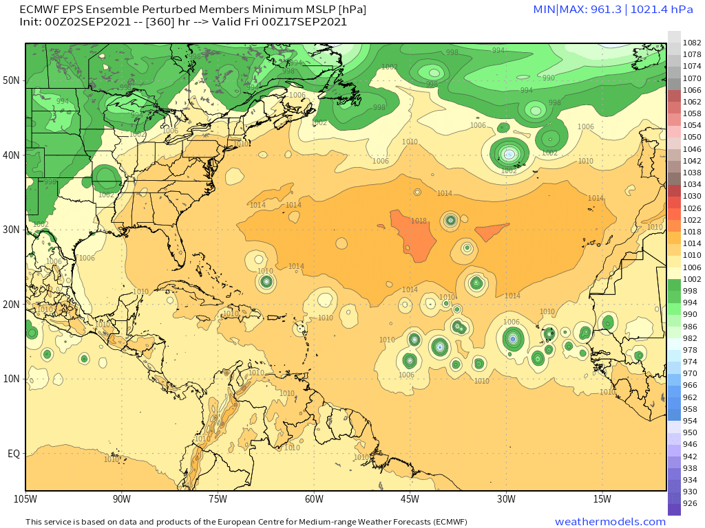
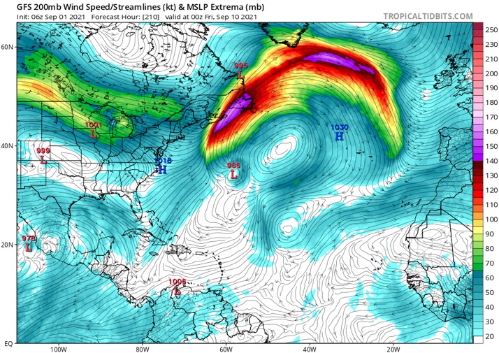
2021 Indicators: SST's / SAL / MSLP / Shear / Steering / Instability / Sat Images

This is the general tropical discussion area. Anyone can take their shot at predicting a storms path.

Moderator: S2k Moderators

Forum rules

The posts in this forum are NOT official forecasts and should not be used as such. They are just the opinion of the poster and may or may not be backed by sound meteorological data. They are NOT endorsed by any professional institution or STORM2K. For official information, please refer to products from the National Hurricane Center and National Weather Service.

Help Support Storm2K
Message
Author
User avatar
Teban54
Category 5
Category 5
Posts: 3206
Joined: Sat May 19, 2018 1:19 pm

Re: 2021 Indicators: SST's / SAL / MSLP / Shear / Steering / Instability / Sat Images

#2981 Postby Teban54 » Wed Sep 01, 2021 3:41 pm

CyclonicFury wrote:
NotSparta wrote:
SFLcane wrote:Larry is potentially going to alter the entire Atlantic as it recurves.

https://i.postimg.cc/zfbmvVK7/DC0-E8-FDB-5-BE1-4-C97-98-FC-5-B21-D2-ECBEC4.jpg


Reminds me recurving WPAC typhoons influencing the downstream flow

It seems relatively common to have a brief respite in Atlantic TC activity after a recurving CV hurricane. The Atlantic was quiet for about 10 days after Teddy last year.

Interestingly, that didn't stop Igor and Julia 2010 from forming and intensifying after Danielle and Earl. Igor formed ~4 days after Earl was gone.
1 likes   

User avatar
CyclonicFury
Category 5
Category 5
Posts: 2025
Age: 26
Joined: Sun Jul 02, 2017 12:32 pm
Location: NC
Contact:

Re: 2021 Indicators: SST's / SAL / MSLP / Shear / Steering / Instability / Sat Images

#2982 Postby CyclonicFury » Wed Sep 01, 2021 3:45 pm

Interestingly, despite the favorable VP200, the CanSIPS doesn't seem to show a very favorable favorable environment for the Atlantic in September or October. The model shows much stronger than normal shear over the MDR and Caribbean in September in particular. Unlike 2020's September CanSIPS forecast for October, which looked incredibly favorable (and verified), this year the CanSIPS isn't showing nearly as favorable of an environment for October, though it does seem to show below average shear in the Gulf of Mexico.

September 2021 CanSIPS shear forecast:
Image

October 2021 CanSIPS shear forecast:
Image

Larry looks likely to rack up quite a bit of ACE, but it appears as if it may be the only show in town for the next week. It's not looking particularly likely at this moment this September will be like the TC spam festival that was September 2020. However, TCs can form in bunches this time of year when there is a favorable CCKW/MJO passage, so it wouldn't be surprising to see another burst of TC activity in the Atlantic in the second half of the month.
6 likes   
NCSU B.S. in Meteorology Class of 2021. Tropical weather blogger at http://www.cyclonicfury.com. My forecasts and thoughts are NOT official, for official forecasts please consult the National Hurricane Center.

AlphaToOmega
Category 5
Category 5
Posts: 1448
Joined: Sat Jun 26, 2021 10:51 am
Location: Somewhere in Massachusetts

Re: 2021 Indicators: SST's / SAL / MSLP / Shear / Steering / Instability / Sat Images

#2983 Postby AlphaToOmega » Wed Sep 01, 2021 3:48 pm

CyclonicFury wrote:Interestingly, despite the favorable VP200, the CanSIPS doesn't seem to show a very favorable favorable environment for the Atlantic in September or October. The model shows much stronger than normal shear over the MDR and Caribbean in September in particular. Unlike 2020's September CanSIPS forecast for October, which looked incredibly favorable (and verified), this year the CanSIPS isn't showing nearly as favorable of an environment for October, though it does seem to show below average shear in the Gulf of Mexico.

September 2021 CanSIPS shear forecast:
https://i.imgur.com/hyG12mB.png

October 2021 CanSIPS shear forecast:
https://i.imgur.com/fWdgZq4.png

Larry looks likely to rack up quite a bit of ACE, but it appears as if it may be the only show in town for the next week. It's not looking particularly likely at this moment this September will be like the TC spam festival that was September 2020. However, TCs can form in bunches this time of year when there is a favorable CCKW/MJO passage, so it wouldn't be surprising to see another burst of TC activity in the Atlantic in the second half of the month.


I would personally not give too much weight to shear forecasts. They can be pretty unreliable. They are also showing above-average shear in the Caribbean despite a La Nina, which makes no little sense.
3 likes   

User avatar
Teban54
Category 5
Category 5
Posts: 3206
Joined: Sat May 19, 2018 1:19 pm

Re: 2021 Indicators: SST's / SAL / MSLP / Shear / Steering / Instability / Sat Images

#2984 Postby Teban54 » Wed Sep 01, 2021 4:31 pm

Meanwhile, pure statistics and historical reference continue to hint at hyperactivity:
 https://twitter.com/philklotzbach/status/1433168625825984513


4 of the 6 years mentioned were hyperactive years.
0 likes   

AlphaToOmega
Category 5
Category 5
Posts: 1448
Joined: Sat Jun 26, 2021 10:51 am
Location: Somewhere in Massachusetts

Re: 2021 Indicators: SST's / SAL / MSLP / Shear / Steering / Instability / Sat Images

#2985 Postby AlphaToOmega » Wed Sep 01, 2021 4:34 pm

I went through the archives, and I found out that 2005 October was more active than 2005 September. Every indicator points to a very active September, but if 2021 September ends up being relatively inactive, it could compensate for a very active October.

P.S: By "relatively inactive", I mean fewer than seven storms forming within the month.
Last edited by AlphaToOmega on Wed Sep 01, 2021 4:51 pm, edited 1 time in total.
0 likes   

User avatar
Woofde
Category 1
Category 1
Posts: 480
Joined: Tue Jul 06, 2021 11:33 am

Re: RE: Re: 2021 Indicators: SST's / SAL / MSLP / Shear / Steering / Instability / Sat Images

#2986 Postby Woofde » Wed Sep 01, 2021 4:49 pm

AlphaToOmega wrote:I went through the archives, and I found out that 2005 October was more active than 2005 September. Every indicator points to a very active September, but if 2021 September ends up being relatively inactive, it could compensate for a very active October.
I agree a more active October this year is very possible. The MJO is swinging away from the Atlantic right now which will hurt September, but in all likelihood it will be back for October, especially now that La Nina is getting into full swing.

That said September is still September so having some powerful storms would not be surprising.
0 likes   

User avatar
Category5Kaiju
Category 5
Category 5
Posts: 4097
Joined: Thu Dec 24, 2020 12:45 pm
Location: Seattle

Re: 2021 Indicators: SST's / SAL / MSLP / Shear / Steering / Instability / Sat Images

#2987 Postby Category5Kaiju » Wed Sep 01, 2021 4:59 pm

Are these models predicting a quiet Atlantic AND a quiet EPAC for September or are they predicting a busy EPAC? Because the former would make very little sense. A busy EPAC and quiet Atlantic makes more sense, but then again, we’re well in -ENSO territory, so I am a bit skeptical to see a very active EPAC and quiet Atlantic, from my understanding you wouldn’t really see that in a to-be La Niña year, especially in September of all months
0 likes   
Unless explicitly stated, all info in my posts is based on my own opinions and observations. Tropical storms and hurricanes can be extremely dangerous. Do not think you can beat Mother Nature. Refer to an accredited weather research agency or meteorologist if you need to make serious decisions regarding an approaching storm.

AlphaToOmega
Category 5
Category 5
Posts: 1448
Joined: Sat Jun 26, 2021 10:51 am
Location: Somewhere in Massachusetts

Re: 2021 Indicators: SST's / SAL / MSLP / Shear / Steering / Instability / Sat Images

#2988 Postby AlphaToOmega » Wed Sep 01, 2021 5:05 pm

Category5Kaiju wrote:Are these models predicting a quiet Atlantic AND a quiet EPAC for September or are they predicting a busy EPAC? Because the former would make very little sense. A busy EPAC and quiet Atlantic makes more sense, but then again, we’re well in -ENSO territory, so I am a bit skeptical to see a very active EPAC and quiet Atlantic, from my understanding you wouldn’t really see that in a to-be La Niña year, especially in September of all months


The ECMWF is forecasting a busy Atlantic and a quiet East Pacific, which is expected for a La Nina. The GFS is forecasting a quiet Atlantic and a quiet East Pacific, which would require conditions similar to those in 1977. As always, the GFS wants to kill the West African Monsoon.
0 likes   

User avatar
aspen
Category 5
Category 5
Posts: 8818
Joined: Sat Oct 12, 2019 7:10 pm
Location: Connecticut, USA

Re: 2021 Indicators: SST's / SAL / MSLP / Shear / Steering / Instability / Sat Images

#2989 Postby aspen » Wed Sep 01, 2021 5:07 pm

CyclonicFury wrote:Interestingly, despite the favorable VP200, the CanSIPS doesn't seem to show a very favorable favorable environment for the Atlantic in September or October. The model shows much stronger than normal shear over the MDR and Caribbean in September in particular. Unlike 2020's September CanSIPS forecast for October, which looked incredibly favorable (and verified), this year the CanSIPS isn't showing nearly as favorable of an environment for October, though it does seem to show below average shear in the Gulf of Mexico.

September 2021 CanSIPS shear forecast:
https://i.imgur.com/hyG12mB.png

October 2021 CanSIPS shear forecast:
https://i.imgur.com/fWdgZq4.png

Larry looks likely to rack up quite a bit of ACE, but it appears as if it may be the only show in town for the next week. It's not looking particularly likely at this moment this September will be like the TC spam festival that was September 2020. However, TCs can form in bunches this time of year when there is a favorable CCKW/MJO passage, so it wouldn't be surprising to see another burst of TC activity in the Atlantic in the second half of the month.

The CFS and CanSIPS have been constantly forecasting high, Niño-like shear across the basin in ASO, but look at how active August was, even with the first third of the month being suppressed by the MJO. I just can’t see how that’s going to verify with a La Niña on the horizon and now significant EPac activity expected in the short term. Typhoon-created TUTTs are also off the table until the WPac wakes up.
5 likes   
Irene '11 Sandy '12 Hermine '16 5/15/2018 Derecho Fay '20 Isaias '20 Elsa '21 Henri '21 Ida '21

I am only a meteorology enthusiast who knows a decent amount about tropical cyclones. Look to the professional mets, the NHC, or your local weather office for the best information.


AlphaToOmega
Category 5
Category 5
Posts: 1448
Joined: Sat Jun 26, 2021 10:51 am
Location: Somewhere in Massachusetts

Re: 2021 Indicators: SST's / SAL / MSLP / Shear / Steering / Instability / Sat Images

#2991 Postby AlphaToOmega » Wed Sep 01, 2021 8:16 pm

Here is why I think September is not going to be as inactive as many people think, and it boils down to one word: climatology.
September 2018 and September 2019 did not have objectively favorable patterns for tropical cyclogenesis. Despite that, each month produced seven storms. If 2018 and 2019 could do it, both El Niño years, 2021, a La Niña year, could do it. There is a reason why September is typically the most active month for the Atlantic: a combination of warm SSTs, a lack of dry air, and low wind shear. Climatology is a very powerful force that can only be fought in very anomalous circumstances.
Image
Image
0 likes   

User avatar
Category5Kaiju
Category 5
Category 5
Posts: 4097
Joined: Thu Dec 24, 2020 12:45 pm
Location: Seattle

Re: 2021 Indicators: SST's / SAL / MSLP / Shear / Steering / Instability / Sat Images

#2992 Postby Category5Kaiju » Wed Sep 01, 2021 8:20 pm


I mean, this personally is not surprising; after all, September Remember as the saying goes?
0 likes   
Unless explicitly stated, all info in my posts is based on my own opinions and observations. Tropical storms and hurricanes can be extremely dangerous. Do not think you can beat Mother Nature. Refer to an accredited weather research agency or meteorologist if you need to make serious decisions regarding an approaching storm.

User avatar
SFLcane
S2K Supporter
S2K Supporter
Posts: 10163
Age: 47
Joined: Sat Jun 05, 2010 1:44 pm
Location: Lake Worth Florida

Re: 2021 Indicators: SST's / SAL / MSLP / Shear / Steering / Instability / Sat Images

#2993 Postby SFLcane » Thu Sep 02, 2021 6:13 am

So, a pattern change is potentially coming with more ridging across the Atlantic basin. I believe 1-2 systems will be making it west. Eps long range signal growing for these systems also.

Image
0 likes   

User avatar
SFLcane
S2K Supporter
S2K Supporter
Posts: 10163
Age: 47
Joined: Sat Jun 05, 2010 1:44 pm
Location: Lake Worth Florida

Re: 2021 Indicators: SST's / SAL / MSLP / Shear / Steering / Instability / Sat Images

#2994 Postby SFLcane » Thu Sep 02, 2021 6:44 am

This is dangerous if it verified. :eek:

Image
0 likes   

Shell Mound
Category 5
Category 5
Posts: 2434
Age: 32
Joined: Thu Sep 07, 2017 3:39 pm
Location: St. Petersburg, FL → Scandinavia

Re: 2021 Indicators: SST's / SAL / MSLP / Shear / Steering / Instability / Sat Images

#2995 Postby Shell Mound » Thu Sep 02, 2021 8:28 am

CyclonicFury wrote:Interestingly, despite the favorable VP200, the CanSIPS doesn't seem to show a very favorable favorable environment for the Atlantic in September or October. The model shows much stronger than normal shear over the MDR and Caribbean in September in particular. Unlike 2020's September CanSIPS forecast for October, which looked incredibly favorable (and verified), this year the CanSIPS isn't showing nearly as favorable of an environment for October, though it does seem to show below average shear in the Gulf of Mexico.

Why do you think the model is showing a Niño-type shear configuration in the MDR and Caribbean during September?
0 likes   
CVW / MiamiensisWx / Shell Mound
The posts in this forum are NOT official forecasts and should not be used as such. They are just the opinion of the poster and may or may not be backed by sound meteorological data. They are NOT endorsed by any professional institution or STORM2K. For official information, please refer to products from the NHC and NWS.

Shell Mound
Category 5
Category 5
Posts: 2434
Age: 32
Joined: Thu Sep 07, 2017 3:39 pm
Location: St. Petersburg, FL → Scandinavia

Re: 2021 Indicators: SST's / SAL / MSLP / Shear / Steering / Instability / Sat Images

#2996 Postby Shell Mound » Thu Sep 02, 2021 8:29 am


Will there be anything out there to take advantage? If so, will shear be too high by then? After Larry conditions look to be rather hostile for storms in the MDR.
0 likes   
CVW / MiamiensisWx / Shell Mound
The posts in this forum are NOT official forecasts and should not be used as such. They are just the opinion of the poster and may or may not be backed by sound meteorological data. They are NOT endorsed by any professional institution or STORM2K. For official information, please refer to products from the NHC and NWS.

User avatar
SFLcane
S2K Supporter
S2K Supporter
Posts: 10163
Age: 47
Joined: Sat Jun 05, 2010 1:44 pm
Location: Lake Worth Florida

Re: 2021 Indicators: SST's / SAL / MSLP / Shear / Steering / Instability / Sat Images

#2997 Postby SFLcane » Thu Sep 02, 2021 8:36 am

Shell Mound wrote:

Will there be anything out there to take advantage? If so, will shear be too high by then? After Larry conditions look to be rather hostile for storms in the MDR.


Growing EPS signal after Larry. Conditions look quite favorable

Image
5 likes   

Shell Mound
Category 5
Category 5
Posts: 2434
Age: 32
Joined: Thu Sep 07, 2017 3:39 pm
Location: St. Petersburg, FL → Scandinavia

Re: 2021 Indicators: SST's / SAL / MSLP / Shear / Steering / Instability / Sat Images

#2998 Postby Shell Mound » Thu Sep 02, 2021 8:46 am

SFLcane wrote:
Shell Mound wrote:

Will there be anything out there to take advantage? If so, will shear be too high by then? After Larry conditions look to be rather hostile for storms in the MDR.

Growing EPS signal after Larry. Conditions look quite favorable

https://i.postimg.cc/fLVS4Bn5/BCB68125-2308-4598-9-D77-62655913-D945.png

Those storms are forming during the third week of September. That’s almost certainly too late for a storm forming in the MDR to affect the CONUS.

A storm forming on 16 September in the MDR affecting the CONUS? Even with the strongest ridging in place, climatology is overwhelmingly against it.
0 likes   
CVW / MiamiensisWx / Shell Mound
The posts in this forum are NOT official forecasts and should not be used as such. They are just the opinion of the poster and may or may not be backed by sound meteorological data. They are NOT endorsed by any professional institution or STORM2K. For official information, please refer to products from the NHC and NWS.

User avatar
SFLcane
S2K Supporter
S2K Supporter
Posts: 10163
Age: 47
Joined: Sat Jun 05, 2010 1:44 pm
Location: Lake Worth Florida

Re: 2021 Indicators: SST's / SAL / MSLP / Shear / Steering / Instability / Sat Images

#2999 Postby SFLcane » Thu Sep 02, 2021 8:56 am

Shell Mound wrote:
SFLcane wrote:
Shell Mound wrote:Will there be anything out there to take advantage? If so, will shear be too high by then? After Larry conditions look to be rather hostile for storms in the MDR.

Growing EPS signal after Larry. Conditions look quite favorable

https://i.postimg.cc/fLVS4Bn5/BCB68125-2308-4598-9-D77-62655913-D945.png

Those storms are forming during the third week of September. That’s almost certainly too late for a storm forming in the MDR to affect the CONUS.

A storm forming on 16 September in the MDR affecting the CONUS? Even with the strongest ridging in place, climatology is overwhelmingly against it.


Down start with the down casting I’d appreciate it. Ridging is forecast to be quite strong for early mid September. Your predictions this season have been slightly off. :wink: :roll:
6 likes   

Nuno
Category 2
Category 2
Posts: 597
Joined: Fri Aug 30, 2019 8:35 am
Location: Coral Gables, FL

Re: 2021 Indicators: SST's / SAL / MSLP / Shear / Steering / Instability / Sat Images

#3000 Postby Nuno » Thu Sep 02, 2021 10:16 am

Shell Mound wrote:

Will there be anything out there to take advantage? If so, will shear be too high by then? After Larry conditions look to be rather hostile for storms in the MDR.


Shell, you've been saying similar comments after each storm and they keep forming...
11 likes   
Andrew (1992), Irene (1999), Frances (2004), Katrina (2005), Wilma (2005), Fay (2008), Irma (2017), Eta (2020), Ian (2022)


Return to “Talkin' Tropics”

Who is online

Users browsing this forum: Orlando_wx and 36 guests