2021 Indicators: SST's / SAL / MSLP / Shear / Steering / Instability / Sat Images

This is the general tropical discussion area. Anyone can take their shot at predicting a storms path.

Moderator: S2k Moderators

Forum rules

The posts in this forum are NOT official forecasts and should not be used as such. They are just the opinion of the poster and may or may not be backed by sound meteorological data. They are NOT endorsed by any professional institution or STORM2K. For official information, please refer to products from the National Hurricane Center and National Weather Service.

Help Support Storm2K
Message
Author
SconnieCane
Category 4
Category 4
Posts: 998
Joined: Thu Aug 02, 2018 5:29 pm
Location: Madison, WI

Re: 2021 Indicators: SST's / SAL / MSLP / Shear / Steering / Instability / Sat Images

#3001 Postby SconnieCane » Thu Sep 02, 2021 11:49 am

Shell Mound wrote:
SFLcane wrote:
Shell Mound wrote:Will there be anything out there to take advantage? If so, will shear be too high by then? After Larry conditions look to be rather hostile for storms in the MDR.

Growing EPS signal after Larry. Conditions look quite favorable

https://i.postimg.cc/fLVS4Bn5/BCB68125-2308-4598-9-D77-62655913-D945.png

Those storms are forming during the third week of September. That’s almost certainly too late for a storm forming in the MDR to affect the CONUS.

A storm forming on 16 September in the MDR affecting the CONUS? Even with the strongest ridging in place, climatology is overwhelmingly against it.


2017: Maria hit PR on 9/20 and might well have also hit the CONUS had not Jose stalled off New England several days earlier leaving a weakness in the ridge.
3 likes   

Shell Mound
Category 5
Category 5
Posts: 2434
Age: 32
Joined: Thu Sep 07, 2017 3:39 pm
Location: St. Petersburg, FL → Scandinavia

Re: 2021 Indicators: SST's / SAL / MSLP / Shear / Steering / Instability / Sat Images

#3002 Postby Shell Mound » Thu Sep 02, 2021 12:08 pm

SFLcane wrote:
Shell Mound wrote:
SFLcane wrote:Growing EPS signal after Larry. Conditions look quite favorable

https://i.postimg.cc/fLVS4Bn5/BCB68125-2308-4598-9-D77-62655913-D945.png

Those storms are forming during the third week of September. That’s almost certainly too late for a storm forming in the MDR to affect the CONUS.

A storm forming on 16 September in the MDR affecting the CONUS? Even with the strongest ridging in place, climatology is overwhelmingly against it.


Down start with the down casting I’d appreciate it. Ridging is forecast to be quite strong for early mid September. Your predictions this season have been slightly off. :wink: :roll:

Well, after Ida let’s just say that we can still hope that my “prediction” is correct. :D It would be nice if the rest of the year were to feature no landfalls...
1 likes   
CVW / MiamiensisWx / Shell Mound
The posts in this forum are NOT official forecasts and should not be used as such. They are just the opinion of the poster and may or may not be backed by sound meteorological data. They are NOT endorsed by any professional institution or STORM2K. For official information, please refer to products from the NHC and NWS.

AutoPenalti
Category 5
Category 5
Posts: 4030
Age: 29
Joined: Mon Aug 17, 2015 4:16 pm
Location: Ft. Lauderdale, Florida

Re: 2021 Indicators: SST's / SAL / MSLP / Shear / Steering / Instability / Sat Images

#3003 Postby AutoPenalti » Thu Sep 02, 2021 12:30 pm

Shell Mound wrote:
SFLcane wrote:
Shell Mound wrote:Those storms are forming during the third week of September. That’s almost certainly too late for a storm forming in the MDR to affect the CONUS.

A storm forming on 16 September in the MDR affecting the CONUS? Even with the strongest ridging in place, climatology is overwhelmingly against it.


Down start with the down casting I’d appreciate it. Ridging is forecast to be quite strong for early mid September. Your predictions this season have been slightly off. :wink: :roll:

Well, after Ida let’s just say that we can still hope that my “prediction” is correct. :D It would be nice if the rest of the year were to feature no landfalls...

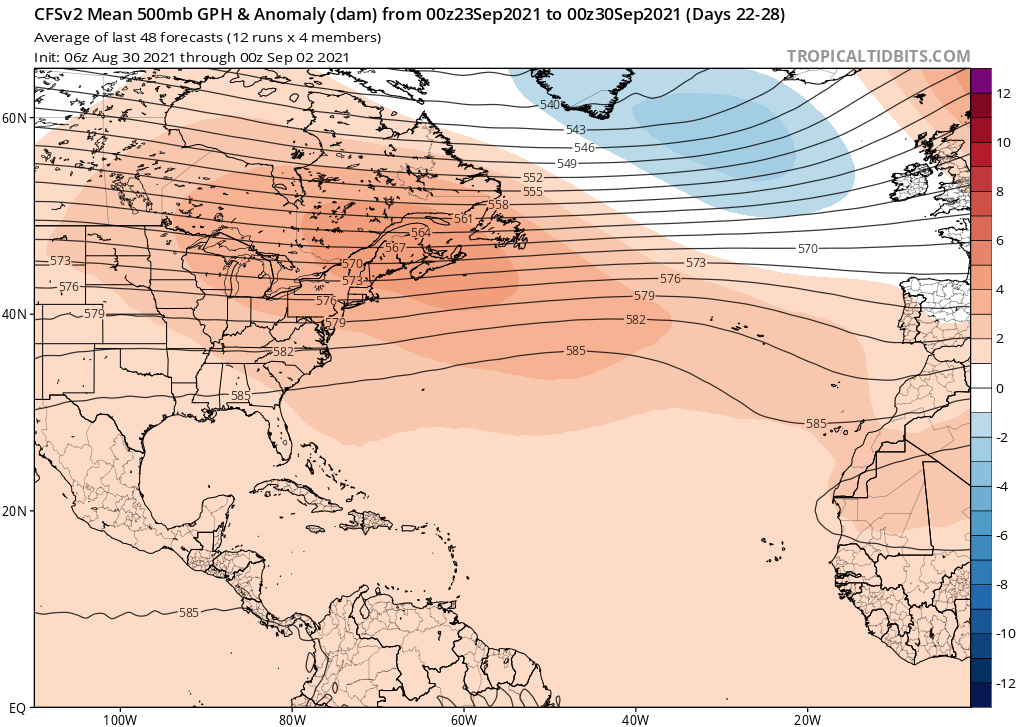
Actually the month of September still remains quite favorable for landfalls, and considering that CFS is suggesting stronger ridging during the latter half of September, this could be something to worry about.
Image
Image

Long range EPS shows this as well...
Image

We can't rule out intraseasonal changes however.
Last edited by AutoPenalti on Thu Sep 02, 2021 12:39 pm, edited 2 times in total.
2 likes   
The posts in this forum are NOT official forecasts and should not be used as such. They are just the opinion of the poster and may or may not be backed by sound meteorological data. They are NOT endorsed by any professional institution or STORM2K. For official information, please refer to products from the NHC and NWS.


Model Runs Cheat Sheet:
GFS (5:30 AM/PM, 11:30 AM/PM)
HWRF, GFDL, UKMET, NAVGEM (6:30-8:00 AM/PM, 12:30-2:00 AM/PM)
ECMWF (1:45 AM/PM)

TCVN
is a weighted averaged

User avatar
toad strangler
S2K Supporter
S2K Supporter
Posts: 4543
Joined: Sun Jul 28, 2013 3:09 pm
Location: Earth
Contact:

Re: 2021 Indicators: SST's / SAL / MSLP / Shear / Steering / Instability / Sat Images

#3004 Postby toad strangler » Thu Sep 02, 2021 12:31 pm

Shell Mound wrote:
SFLcane wrote:
Shell Mound wrote:Those storms are forming during the third week of September. That’s almost certainly too late for a storm forming in the MDR to affect the CONUS.

A storm forming on 16 September in the MDR affecting the CONUS? Even with the strongest ridging in place, climatology is overwhelmingly against it.


Down start with the down casting I’d appreciate it. Ridging is forecast to be quite strong for early mid September. Your predictions this season have been slightly off. :wink: :roll:

Well, after Ida let’s just say that we can still hope that my “prediction” is correct. :D It would be nice if the rest of the year were to feature no landfalls...


There is PLENTY …. PLENTY of climo left post Sept 16th that would landfall in the CONUS
3 likes   

User avatar
SFLcane
S2K Supporter
S2K Supporter
Posts: 10163
Age: 47
Joined: Sat Jun 05, 2010 1:44 pm
Location: Lake Worth Florida

Re: 2021 Indicators: SST's / SAL / MSLP / Shear / Steering / Instability / Sat Images

#3005 Postby SFLcane » Thu Sep 02, 2021 12:34 pm

AutoPenalti wrote:
Shell Mound wrote:
SFLcane wrote:
Down start with the down casting I’d appreciate it. Ridging is forecast to be quite strong for early mid September. Your predictions this season have been slightly off. :wink: :roll:

Well, after Ida let’s just say that we can still hope that my “prediction” is correct. :D It would be nice if the rest of the year were to feature no landfalls...

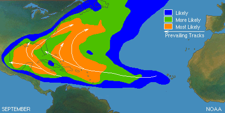
Actually the month of September still remains quite favorable for landfalls.
https://www.nhc.noaa.gov/climo/images/september.gif


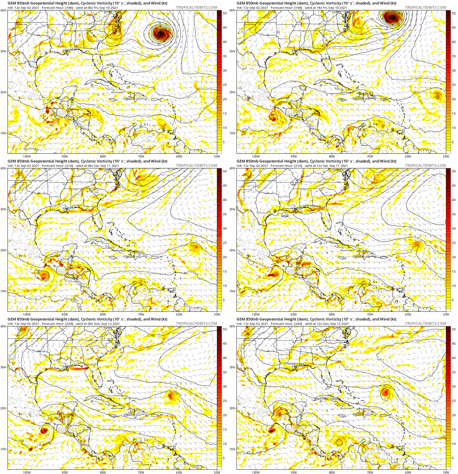
Cmc likes your climo tracks.

Image
5 likes   

AlphaToOmega
Category 5
Category 5
Posts: 1448
Joined: Sat Jun 26, 2021 10:51 am
Location: Somewhere in Massachusetts

Re: 2021 Indicators: SST's / SAL / MSLP / Shear / Steering / Instability / Sat Images

#3006 Postby AlphaToOmega » Thu Sep 02, 2021 1:29 pm

Shell Mound wrote:
CyclonicFury wrote:Interestingly, despite the favorable VP200, the CanSIPS doesn't seem to show a very favorable favorable environment for the Atlantic in September or October. The model shows much stronger than normal shear over the MDR and Caribbean in September in particular. Unlike 2020's September CanSIPS forecast for October, which looked incredibly favorable (and verified), this year the CanSIPS isn't showing nearly as favorable of an environment for October, though it does seem to show below average shear in the Gulf of Mexico.

Why do you think the model is showing a Niño-type shear configuration in the MDR and Caribbean during September?

They showed above-average wind shear in September 2020 for the Caribbean despite a La Niña for 2020-2021. Something is likely wrong with the model.
0 likes   

User avatar
Teban54
Category 5
Category 5
Posts: 3206
Joined: Sat May 19, 2018 1:19 pm

Re: 2021 Indicators: SST's / SAL / MSLP / Shear / Steering / Instability / Sat Images

#3007 Postby Teban54 » Thu Sep 02, 2021 1:38 pm

Has anyone seen or done any kind of analysis on CanSIPS and CFS shear forecasts and verification? While I don't think their current forecasts are realistic given the developing La Nina, I don't think we should immediately write off a model output just because of that either.
0 likes   

User avatar
weeniepatrol
Category 5
Category 5
Posts: 1276
Joined: Sat Aug 22, 2020 5:30 pm
Location: WA State

Re: 2021 Indicators: SST's / SAL / MSLP / Shear / Steering / Instability / Sat Images

#3008 Postby weeniepatrol » Thu Sep 02, 2021 1:44 pm

3 likes   

User avatar
EquusStorm
Category 5
Category 5
Posts: 1649
Age: 34
Joined: Thu Nov 07, 2013 1:04 pm
Location: Jasper, AL
Contact:

Re: 2021 Indicators: SST's / SAL / MSLP / Shear / Steering / Instability / Sat Images

#3009 Postby EquusStorm » Thu Sep 02, 2021 1:48 pm

Wave train looking super spicy... two very large waves with excellent vorticity headed for the Atlantic

Image
9 likes   
Colors of lost purpose on the canvas of irrelevance

Not a meteorologist, in fact more of an idiot than anything. You should probably check with the NHC or a local NWS office for official information.

AlphaToOmega
Category 5
Category 5
Posts: 1448
Joined: Sat Jun 26, 2021 10:51 am
Location: Somewhere in Massachusetts

Re: 2021 Indicators: SST's / SAL / MSLP / Shear / Steering / Instability / Sat Images

#3010 Postby AlphaToOmega » Thu Sep 02, 2021 2:10 pm

000
ABNT30 KNHC 011242
TWSAT

Monthly Tropical Weather Summary
NWS National Hurricane Center Miami FL
800 AM EDT Wed Sep 1 2021

For the North Atlantic...Caribbean Sea and the Gulf of Mexico:

Tropical cyclone activity in the Atlantic basin during August was
above normal in terms of the numbers of named storms, hurricanes,
and major hurricanes. Six named storms formed in the Atlantic basin
in August, with three of them becoming hurricanes, and two of those
becoming major hurricanes. Grace was a category 3 hurricane when it
made landfall just south of Tuxpan, Mexico, on 22 August, and Ida
was a category 4 hurricane when it made landfall near Port Fourchon,
Louisiana, on 29 August. One tropical depression formed on the last
day of the month. Based on a 30-year climatology (1991-2020), 3 or
4 named storms typically develop in August, with one or two of them
becoming hurricanes. A major hurricane forms in August every 1 to 2
years.

In terms of Accumulated Cyclone Energy (ACE), which measures the
strength and duration of tropical storms and hurricanes, activity
in the basin so far in 2021 is above normal, almost 25 percent
above the long-term mean. The 11 named storms through the end of
August is well above the 30-year (1991-2020) average of 6 to 7
named storms by the end of the month.

Reports on individual cyclones, when completed, are available at
the National Hurricane Center website at
www.hurricanes.gov/data/tcr/index.php?s ... &basin=atl

Summary Table

Name Dates Max Wind (mph)
---------------------------------------------------
TS Ana 22-23 May 45*
TS Bill 14-16 Jun 60
TS Claudette 19-22 Jun 45
TS Danny 28-29 Jun 45
H Elsa 1-9 Jul 85
TS Fred 11-18 Aug 65
MH Grace 13-21 Aug 125
H Henri 16-23 Aug 75
MH Ida 26 Aug- 150
TS Kate 28 Aug- 45
TS Julian 29-30 Aug 60
TD Twelve 31 Aug- 35
---------------------------------------------------

* Denotes a storm for which the post-storm analysis is complete.

$$
Hurricane Specialist Unit
1 likes   

User avatar
Hurricaneman
Category 5
Category 5
Posts: 7351
Age: 45
Joined: Tue Aug 31, 2004 3:24 pm
Location: central florida

Re: 2021 Indicators: SST's / SAL / MSLP / Shear / Steering / Instability / Sat Images

#3011 Postby Hurricaneman » Thu Sep 02, 2021 2:21 pm

SFLcane wrote:
AutoPenalti wrote:
Shell Mound wrote:Well, after Ida let’s just say that we can still hope that my “prediction” is correct. :D It would be nice if the rest of the year were to feature no landfalls...

Actually the month of September still remains quite favorable for landfalls.
https://www.nhc.noaa.gov/climo/images/september.gif


Cmc likes your climo tracks.

https://i.postimg.cc/k5Rft9t9/49-A06953-933-D-42-F1-9-A5-D-726-B295-B0724.gif


Look what the Canadian does with 92L, seems like the steering pattern after Larry may lead to east coast landfalls so it’s something to watch for

Also uneasy about October and possibly November due to La Niña coming on
0 likes   

User avatar
gatorcane
S2K Supporter
S2K Supporter
Posts: 23691
Age: 47
Joined: Sun Mar 13, 2005 3:54 pm
Location: Boca Raton, FL

Re: 2021 Indicators: SST's / SAL / MSLP / Shear / Steering / Instability / Sat Images

#3012 Postby gatorcane » Thu Sep 02, 2021 3:18 pm

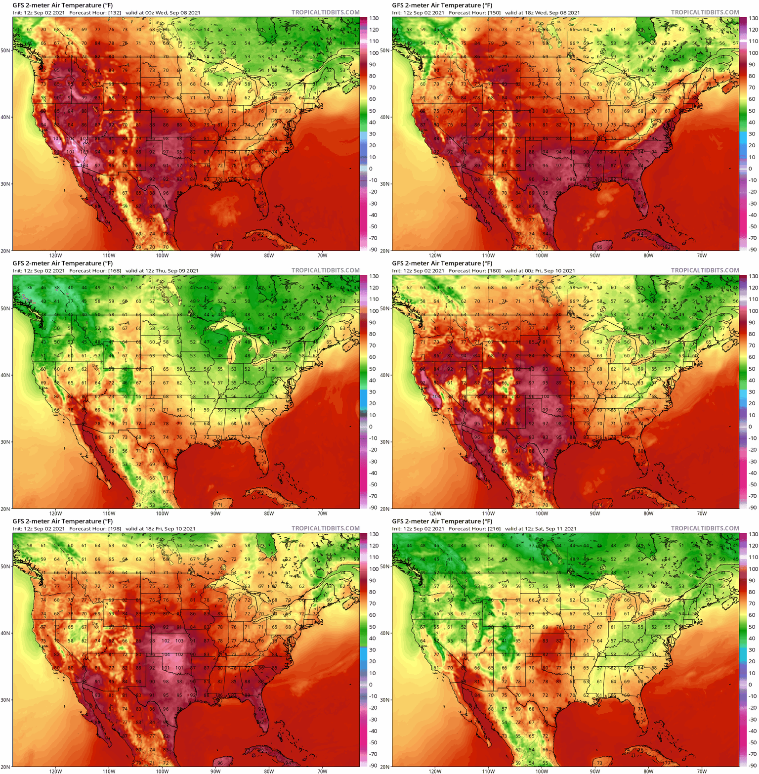
Seems like a taste of fall for the eastern CONUS on the GFS with 60s down to the northern Gulf coast which is below normal if it verifies. Indicator of the fall pattern coming early this year and winding down the season for the CONUS early? (Wistful thinking)

Image
0 likes   

IcyTundra
Category 5
Category 5
Posts: 1205
Joined: Mon Jun 07, 2021 9:32 pm
Location: Dickinson, Texas

Re: 2021 Indicators: SST's / SAL / MSLP / Shear / Steering / Instability / Sat Images

#3013 Postby IcyTundra » Thu Sep 02, 2021 3:21 pm

gatorcane wrote:Seems like a taste of fall for the eastern CONUS on the GFS with 60s down to the northern Gulf coast which is below normal if it verifies. Indicator of the fall pattern coming early this year and wind down the season for the CONUS early? (Wistful thinking)

https://i.postimg.cc/gJfxcFSB/gfs-T2m-us-fh132-216.gif


GFS always shows the first cold front getting further south than it gets in reality.
5 likes   

AutoPenalti
Category 5
Category 5
Posts: 4030
Age: 29
Joined: Mon Aug 17, 2015 4:16 pm
Location: Ft. Lauderdale, Florida

Re: 2021 Indicators: SST's / SAL / MSLP / Shear / Steering / Instability / Sat Images

#3014 Postby AutoPenalti » Thu Sep 02, 2021 3:49 pm

gatorcane wrote:Seems like a taste of fall for the eastern CONUS on the GFS with 60s down to the northern Gulf coast which is below normal if it verifies. Indicator of the fall pattern coming early this year and winding down the season for the CONUS early? (Wistful thinking)

https://i.postimg.cc/gJfxcFSB/gfs-T2m-us-fh132-216.gif

If that verifies, and it wont, any MDR system will be lifted ots.
0 likes   
The posts in this forum are NOT official forecasts and should not be used as such. They are just the opinion of the poster and may or may not be backed by sound meteorological data. They are NOT endorsed by any professional institution or STORM2K. For official information, please refer to products from the NHC and NWS.


Model Runs Cheat Sheet:
GFS (5:30 AM/PM, 11:30 AM/PM)
HWRF, GFDL, UKMET, NAVGEM (6:30-8:00 AM/PM, 12:30-2:00 AM/PM)
ECMWF (1:45 AM/PM)

TCVN
is a weighted averaged

User avatar
SFLcane
S2K Supporter
S2K Supporter
Posts: 10163
Age: 47
Joined: Sat Jun 05, 2010 1:44 pm
Location: Lake Worth Florida

Re: 2021 Indicators: SST's / SAL / MSLP / Shear / Steering / Instability / Sat Images

#3015 Postby SFLcane » Thu Sep 02, 2021 7:02 pm

Better hope nothing moves off Africa and a decent latitude after Larry. Trouble incoming if so

 https://twitter.com/jacksillin/status/1433578271636140034


1 likes   

User avatar
Teban54
Category 5
Category 5
Posts: 3206
Joined: Sat May 19, 2018 1:19 pm

Re: 2021 Indicators: SST's / SAL / MSLP / Shear / Steering / Instability / Sat Images

#3016 Postby Teban54 » Thu Sep 02, 2021 7:20 pm

SFLcane wrote:Better hope nothing moves off Africa and a decent latitude after Larry. Trouble incoming if so

https://twitter.com/jacksillin/status/1433578271636140034

IIRC just a few days ago people were posting model runs full of troughs for September, and a while before that the forecast was strong ridging just like they show now. Do the steering forecasts always flip flop like this?
2 likes   

User avatar
gatorcane
S2K Supporter
S2K Supporter
Posts: 23691
Age: 47
Joined: Sun Mar 13, 2005 3:54 pm
Location: Boca Raton, FL

Re: 2021 Indicators: SST's / SAL / MSLP / Shear / Steering / Instability / Sat Images

#3017 Postby gatorcane » Thu Sep 02, 2021 7:46 pm

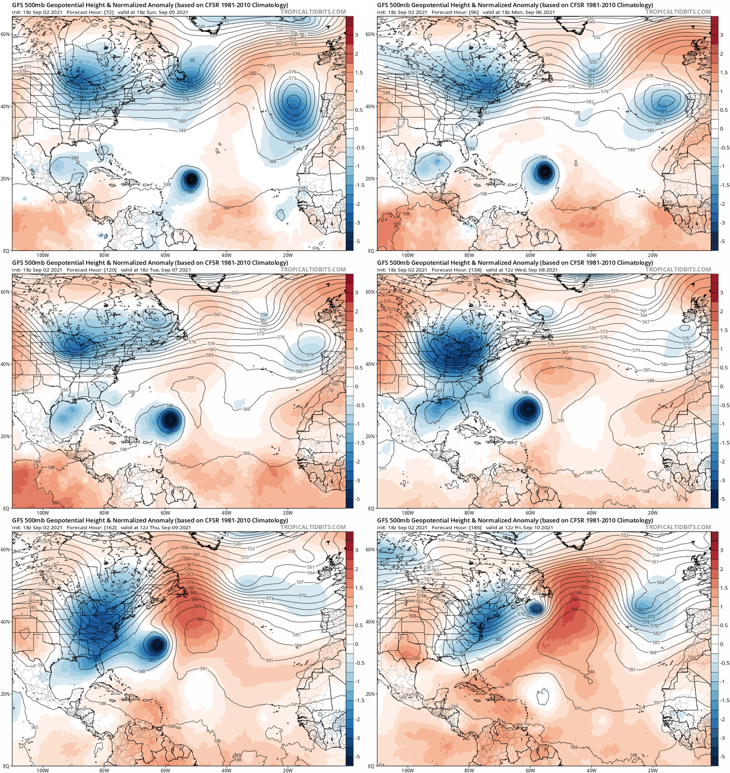
Guess those long-range CFS and other forecasts of ridging over SE Canada come peak of the season I saw some posting in this indicators thread didn’t pan out too well fortunately. A timely one-two punch of big troughs appear to be waiting to turn what might be a large and powerful cyclone Larry away from the US. Not so great for Bermuda maybe though:

Image
0 likes   

User avatar
SFLcane
S2K Supporter
S2K Supporter
Posts: 10163
Age: 47
Joined: Sat Jun 05, 2010 1:44 pm
Location: Lake Worth Florida

Re: 2021 Indicators: SST's / SAL / MSLP / Shear / Steering / Instability / Sat Images

#3018 Postby SFLcane » Thu Sep 02, 2021 7:52 pm

gatorcane wrote:Guess those long-range CFS and other forecasts of ridging over SE Canada come peak of the season I saw some posting in this indicators thread didn’t pan out too well fortunately. A timely one-two punch of big troughs appear to be waiting to turn what might be a large and powerful cyclone Larry away from the US. Not so great for Bermuda maybe though:

https://i.postimg.cc/3rBtyT0z/gfs-z500a-Norm-atl-fh72-186.gif


Wrong… it’s coming

Image
5 likes   

IcyTundra
Category 5
Category 5
Posts: 1205
Joined: Mon Jun 07, 2021 9:32 pm
Location: Dickinson, Texas

Re: 2021 Indicators: SST's / SAL / MSLP / Shear / Steering / Instability / Sat Images

#3019 Postby IcyTundra » Thu Sep 02, 2021 7:56 pm

I have a feeling we are in for at least 1 more major impacting the Carribean Islands or the CONUS lets enjoy this down period for threats close to home.
0 likes   

User avatar
Hammy
Category 5
Category 5
Posts: 5849
Age: 41
Joined: Fri May 25, 2012 5:25 pm
Contact:

Re: 2021 Indicators: SST's / SAL / MSLP / Shear / Steering / Instability / Sat Images

#3020 Postby Hammy » Fri Sep 03, 2021 5:36 am

Recent CFS runs seem to indicate a quiet period, possibly little to nothing new forming for the rest of early to mid-September, at least over the Atlantic ocean itself--something it's been hinting at since July (unfortunately the GoM/Caribbean maps are still having issues loading) but it's showing another burst of activity the last third of September, and continues to show the MDR producing storms into October, with varying intensity from run to run.
1 likes   
The above post is not official and should not be used as such. It is the opinion of the poster and may or may not be backed by sound meteorological data. It is not endorsed by any professional institution or storm2k.org. For official information, please refer to the NHC and NWS products.


Return to “Talkin' Tropics”

Who is online

Users browsing this forum: lolitx and 48 guests