Ugh… the CMC hates the Northern GOM coast. Late in the 00z run it decimates Louisiana and Mississippi. Slow moving storm.
Sent from my iPhone using Tapatalk
2021 Global Model Runs Discussion (Out thru day 16)
Moderator: S2k Moderators
Forum rules

The posts in this forum are NOT official forecasts and should not be used as such. They are just the opinion of the poster and may or may not be backed by sound meteorological data. They are NOT endorsed by any professional institution or STORM2K. For official information, please refer to products from the National Hurricane Center and National Weather Service.
-
SouthFLTropics

- Category 5

- Posts: 4258
- Age: 50
- Joined: Thu Aug 14, 2003 8:04 am
- Location: Port St. Lucie, Florida
Re: 2021 Global Model Runs Discussion (Out thru day 16)
0 likes
Fourth Generation Florida Native
Personal Storm History: David 79, Andrew 92, Erin 95, Floyd 99, Irene 99, Frances 04, Jeanne 04, Wilma 05, Matthew 16, Irma 17, Ian 22, Nicole 22, Milton 24
Personal Storm History: David 79, Andrew 92, Erin 95, Floyd 99, Irene 99, Frances 04, Jeanne 04, Wilma 05, Matthew 16, Irma 17, Ian 22, Nicole 22, Milton 24
-
weeniepatrol

- Category 5
- Posts: 1343
- Joined: Sat Aug 22, 2020 5:30 pm
- Location: WA State


Re: 2021 Global Model Runs Discussion (Out thru day 16)
The 06Z GFS after 246 says I'll take care of the MDR/CV systems 
0 likes
Once I see the REDS and GREENS Converge on a Base Velocity. ... I'm There!!
This is NOT an Official Forecast....Just my Opinion. For official information, please refer to the NHC and NWS products.
HIGHLIGHTS : '13 El Reno Tornado : 2013 Storm Chaser Tour, Joaquin; SC flood event, Matthew '16, Lowcountry Snow storm Jan '18
This is NOT an Official Forecast....Just my Opinion. For official information, please refer to the NHC and NWS products.
HIGHLIGHTS : '13 El Reno Tornado : 2013 Storm Chaser Tour, Joaquin; SC flood event, Matthew '16, Lowcountry Snow storm Jan '18
-
AutoPenalti
- Category 5
- Posts: 4091
- Age: 29
- Joined: Mon Aug 17, 2015 4:16 pm
- Location: Ft. Lauderdale, Florida
Re: 2021 Global Model Runs Discussion (Out thru day 16)
Looks like the Euro ens has this coming off Africa by next week and depending on where Larry is, might even follow it OTS.
0 likes
The posts in this forum are NOT official forecasts and should not be used as such. They are just the opinion of the poster and may or may not be backed by sound meteorological data. They are NOT endorsed by any professional institution or STORM2K. For official information, please refer to products from the NHC and NWS.
Model Runs Cheat Sheet:
GFS (5:30 AM/PM, 11:30 AM/PM)
HWRF, GFDL, UKMET, NAVGEM (6:30-8:00 AM/PM, 12:30-2:00 AM/PM)
ECMWF (1:45 AM/PM)
TCVN is a weighted averaged
-
SFLcane

- S2K Supporter

- Posts: 10281
- Age: 48
- Joined: Sat Jun 05, 2010 1:44 pm
- Location: Lake Worth Florida
Re: 2021 Global Model Runs Discussion (Out thru day 16)
AutoPenalti wrote:
Looks like the Euro ens has this coming off Africa by next week and depending on where Larry is, might even follow it OTS.
Not if the 500mb forecast from the euro and cfs verifies. We’ll have to watch these waves after Larry as a +NA0
will be establishing itself.
2 likes
-
SFLcane
- S2K Supporter
- Posts: 10281
- Age: 48
- Joined: Sat Jun 05, 2010 1:44 pm
- Location: Lake Worth Florida
Re: 2021 Global Model Runs Discussion (Out thru day 16)
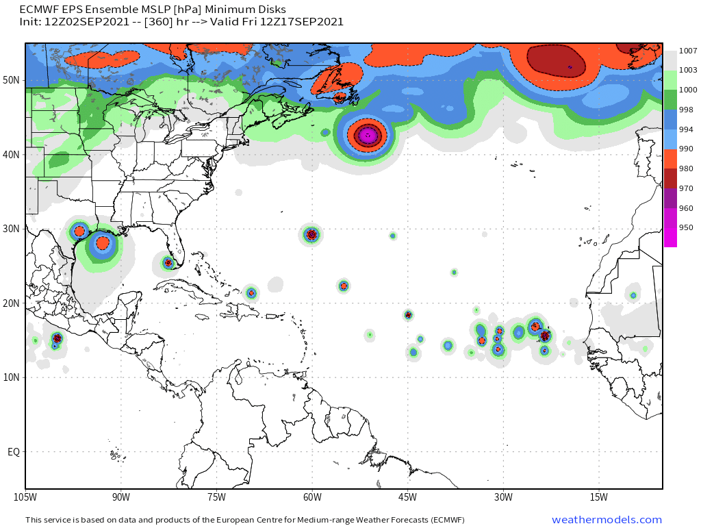
Abstract from Phil K 2 week forecast.
The ECMWF ensemble is fairly aggressive with another African easterly wave-spawned TC emerging off of Africa in about ten days, with potentially another system following in that one’s footsteps a few days later. The latest ensemble minimum MSLP output from ECMWF shows quite a few members with low pressure areas in fifteen days in the eastern tropical Atlantic
The ECMWF ensemble is fairly aggressive with another African easterly wave-spawned TC emerging off of Africa in about ten days, with potentially another system following in that one’s footsteps a few days later. The latest ensemble minimum MSLP output from ECMWF shows quite a few members with low pressure areas in fifteen days in the eastern tropical Atlantic
4 likes
-
AutoPenalti
- Category 5
- Posts: 4091
- Age: 29
- Joined: Mon Aug 17, 2015 4:16 pm
- Location: Ft. Lauderdale, Florida
Re: 2021 Global Model Runs Discussion (Out thru day 16)
SFLcane wrote:AutoPenalti wrote:
Looks like the Euro ens has this coming off Africa by next week and depending on where Larry is, might even follow it OTS.
Not if the 500mb forecast from the euro and cfs verifies. We’ll have to watch these waves after Larry as a +NA0
will be establishing itself.
The Euro long range does show a fragmented but strengthening ridge so yeah it's possible this may be a MDR cruiser.
0 likes
The posts in this forum are NOT official forecasts and should not be used as such. They are just the opinion of the poster and may or may not be backed by sound meteorological data. They are NOT endorsed by any professional institution or STORM2K. For official information, please refer to products from the NHC and NWS.
Model Runs Cheat Sheet:
GFS (5:30 AM/PM, 11:30 AM/PM)
HWRF, GFDL, UKMET, NAVGEM (6:30-8:00 AM/PM, 12:30-2:00 AM/PM)
ECMWF (1:45 AM/PM)
TCVN is a weighted averaged
-
DorkyMcDorkface

- Category 5
- Posts: 1021
- Age: 28
- Joined: Mon Sep 30, 2019 1:32 pm
- Location: Mid-Atlantic
Re: 2021 Global Model Runs Discussion (Out thru day 16)
06z Euro with another TC developing right off Africa at the end of the run.

Sure enough there is a decent EPS signal:

Given that there is a potent CCKW expected to pass over Africa over the next week I would expect to see more models following suit on picking up more activity.

Sure enough there is a decent EPS signal:
Given that there is a potent CCKW expected to pass over Africa over the next week I would expect to see more models following suit on picking up more activity.
4 likes
Please note the thoughts expressed by this account are solely those of the user and are from a hobbyist perspective. For more comprehensive analysis, consult an actual professional meteorologist or meteorological agency.
Floyd 1999 | Isabel 2003 | Hanna 2008 | Irene 2011 | Sandy 2012 | Isaias 2020

Re: 2021 Global Model Runs Discussion (Out thru day 16)
DorkyMcDorkface wrote:06z Euro with another TC developing right off Africa at the end of the run.
https://cdn.discordapp.com/attachments/733552978572869632/882996575935287296/index.png
Sure enough there is a decent EPS signal:
https://i.ibb.co/Thn8gp2/ecens-2021-09-02-06-Z-144-50-258-0-350-MSLP-Surface-tracks-lows.png
Given that there is a potent CCKW expected to pass over Africa over the next week I would expect to see more models following suit on picking up more activity.
https://i.ibb.co/JyjLgF4/28.gif
It’s coming off of at a rather high latitude, so it would be straddling the boundary between 27/26C SSTs until it gets past 45W. I don’t anticipate genesis and intensification at the same rate as Larry.
0 likes
Irene '11 Sandy '12 Hermine '16 5/15/2018 Derecho Fay '20 Isaias '20 Elsa '21 Henri '21 Ida '21
I am only a meteorology enthusiast who knows a decent amount about tropical cyclones. Look to the professional mets, the NHC, or your local weather office for the best information.
I am only a meteorology enthusiast who knows a decent amount about tropical cyclones. Look to the professional mets, the NHC, or your local weather office for the best information.

Re: 2021 Global Model Runs Discussion (Out thru day 16)
I would expect any storm even close to this well developed just coming off the African coastline to immediately track northwest and out to see (as in "see yaaaaa" later - alligator
This suggests to me two things. One, that the MDR has proven that conditions are truly healthy out east and conditions are prolific enough where a few more storms will likely develop out east this month. Two, those that will form in the Eastern Atlantic will quite likely follow a similar track pattern as Larry. Hopefully this will give a temporary reprieve to most of the Caribbean and Antilles for a few weeks. With La Nina taking shape and having an increased influence with time, October might prove to be very interesting as Climo shifts development back to the west Atlantic basin.
3 likes
Andy D
(For official information, please refer to the NHC and NWS products.)
(For official information, please refer to the NHC and NWS products.)
-
SFLcane
- S2K Supporter
- Posts: 10281
- Age: 48
- Joined: Sat Jun 05, 2010 1:44 pm
- Location: Lake Worth Florida
Re: 2021 Global Model Runs Discussion (Out thru day 16)
aspen wrote:DorkyMcDorkface wrote:06z Euro with another TC developing right off Africa at the end of the run.
https://cdn.discordapp.com/attachments/733552978572869632/882996575935287296/index.png
Sure enough there is a decent EPS signal:
https://i.ibb.co/Thn8gp2/ecens-2021-09-02-06-Z-144-50-258-0-350-MSLP-Surface-tracks-lows.png
Given that there is a potent CCKW expected to pass over Africa over the next week I would expect to see more models following suit on picking up more activity.
https://i.ibb.co/JyjLgF4/28.gif
It’s coming off of at a rather high latitude, so it would be straddling the boundary between 27/26C SSTs until it gets past 45W. I don’t anticipate genesis and intensification at the same rate as Larry.
Typical high bias with the Euro.
1 likes
-
AlphaToOmega
- Category 5
- Posts: 1448
- Joined: Sat Jun 26, 2021 10:51 am
- Location: Somewhere in Massachusetts
Re: 2021 Global Model Runs Discussion (Out thru day 16)
The CMC has done very well with the geneses of Ida, Julian, Kate, and Larry. For August, it has performed very well.
The operational CMC shows development from a wave after Invest 92L and from the Central American Gyre. By September 7, it shows development of Tropical Storm Mindy in the Bay of Campeche and Tropical Storm Nicholas in the MDR. Then on September 9, it shows development of Tropical Storm Odette in the MDR.
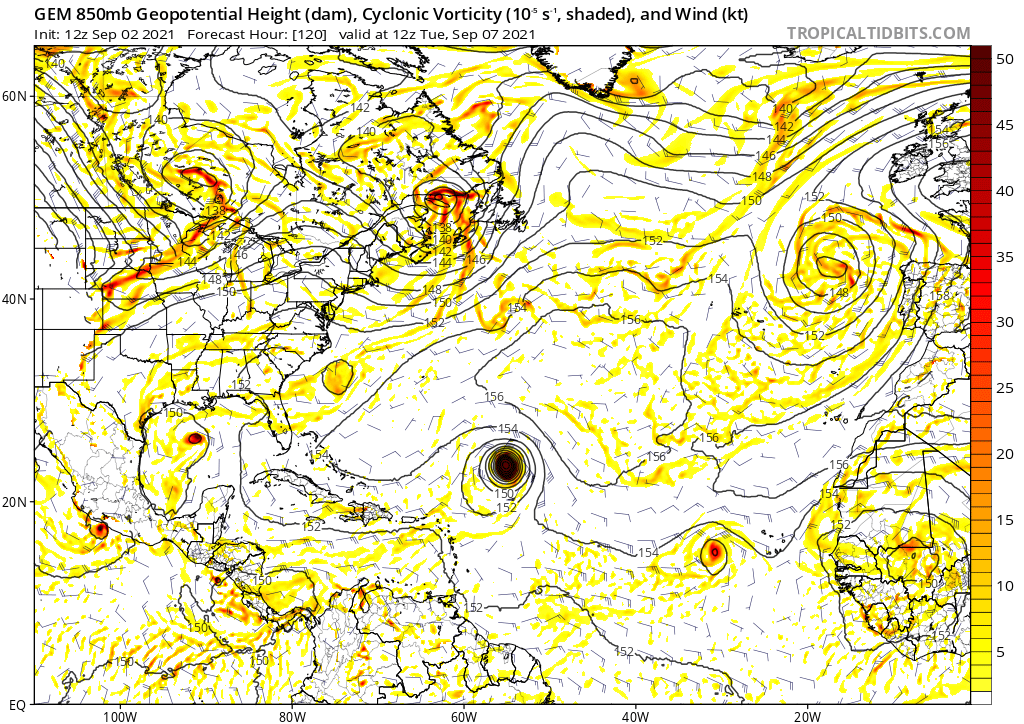
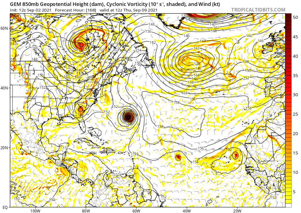
The operational CMC shows development from a wave after Invest 92L and from the Central American Gyre. By September 7, it shows development of Tropical Storm Mindy in the Bay of Campeche and Tropical Storm Nicholas in the MDR. Then on September 9, it shows development of Tropical Storm Odette in the MDR.
Last edited by AlphaToOmega on Thu Sep 02, 2021 3:06 pm, edited 1 time in total.
0 likes
Re: 2021 Global Model Runs Discussion (Out thru day 16)
DorkyMcDorkface wrote:06z Euro with another TC developing right off Africa at the end of the run.
https://cdn.discordapp.com/attachments/733552978572869632/882996575935287296/index.png
Sure enough there is a decent EPS signal:
https://i.ibb.co/Thn8gp2/ecens-2021-09-02-06-Z-144-50-258-0-350-MSLP-Surface-tracks-lows.png
Given that there is a potent CCKW expected to pass over Africa over the next week I would expect to see more models following suit on picking up more activity.
https://i.ibb.co/JyjLgF4/28.gif
This is one I’ve been watching for two days as the EPS runs have been bullish on this since then (coming off Africa ~9/11). And now the 12Z Euro, like the 0Z Euro, has a TS at the end of the run from an AEW leaving Africa on 9/11. (consistent with the EPS runs I just noted). I can’t post it right now. But note how strong the central Atlantic high is to the NNW of it. If that were to verify, this likely wouldn’t recurve early and may even soon after this start moving WSW for a period, which is a warning signal as Yaakov (@jconsor) and I have noted, especially with the La Nina(ish) ENSO.
(I remain unworried about my namesake storm from a SE US perspective though Bermuda, Canada, and even New England should monitor).
1 likes
Personal Forecast Disclaimer:
The posts in this forum are NOT official forecasts and should not be used as such. They are just the opinion of the poster and may or may not be backed by sound meteorological data. They are NOT endorsed by any professional institution or storm2k.org. For official information, please refer to the NHC and NWS products.
The posts in this forum are NOT official forecasts and should not be used as such. They are just the opinion of the poster and may or may not be backed by sound meteorological data. They are NOT endorsed by any professional institution or storm2k.org. For official information, please refer to the NHC and NWS products.
-
SFLcane
- S2K Supporter
- Posts: 10281
- Age: 48
- Joined: Sat Jun 05, 2010 1:44 pm
- Location: Lake Worth Florida
Re: 2021 Global Model Runs Discussion (Out thru day 16)
LarryWx wrote:DorkyMcDorkface wrote:06z Euro with another TC developing right off Africa at the end of the run.
https://cdn.discordapp.com/attachments/733552978572869632/882996575935287296/index.png
Sure enough there is a decent EPS signal:
https://i.ibb.co/Thn8gp2/ecens-2021-09-02-06-Z-144-50-258-0-350-MSLP-Surface-tracks-lows.png
Given that there is a potent CCKW expected to pass over Africa over the next week I would expect to see more models following suit on picking up more activity.
https://i.ibb.co/JyjLgF4/28.gif
This is one I’ve been watching for two days as the EPS runs have been bullish on this since then (coming off Africa ~9/11). And now the 12Z Euro, like the 0Z Euro, has a TS at the end of the run from an AEW leaving Africa on 9/11. (consistent with the EPS runs I just noted). I can’t post it right now. But note how strong the central Atlantic high is to the NNW of it. If that were to verify, this likely wouldn’t recurve early and may even soon after this start moving WSW for a period, which is a warning signal as Yaakov (@jconsor) and I have noted, especially with the La Nina(ish) ENSO.
(I remain unworried about my namesake storm from a SE US perspective though Bermuda, Canada, and even New England should monitor).
1 likes
-
Category5Kaiju

- Category 5
- Posts: 4336
- Joined: Thu Dec 24, 2020 12:45 pm
- Location: Seattle during the summer, Phoenix during the winter
Re: 2021 Global Model Runs Discussion (Out thru day 16)
Being an individual whose first name is actually Nicholas, I can't wait to see what TS Nicholas will be born out of. The Gulf system, or the MDR system after Larry? 
1 likes
Unless explicitly stated, all information in my posts is based on my own opinions and observations. Tropical storms and hurricanes can be extremely dangerous. Refer to an accredited weather research agency or meteorologist if you need to make serious decisions regarding an approaching storm.
Re: 2021 Global Model Runs Discussion (Out thru day 16)
Interesting that the usually bearish Ukmet is developing the wave behind 92L, actually forming just south of the CV Islands late in the weekend. This is the same feature that the CMC has wandering around just north of PR by D10
0 likes
Re: 2021 Global Model Runs Discussion (Out thru day 16)
sma10 wrote:Interesting that the usually bearish Ukmet is developing the wave behind 92L, actually forming just south of the CV Islands late in the weekend. This is the same feature that the CMC has wandering around just north of PR by D10
Here is the 0Z UKMET (keeps it weak):
NEW TROPICAL CYCLONE FORECAST TO DEVELOP AFTER 78 HOURS
FORECAST POSITION AT T+ 78 : 13.6N 20.6W
LEAD CENTRAL MAXIMUM WIND
VERIFYING TIME TIME POSITION PRESSURE (MB) SPEED (KNOTS)
-------------- ---- -------- ------------- -------------
1200UTC 06.09.2021 84 13.7N 22.0W 1008 29
0000UTC 07.09.2021 96 14.5N 24.4W 1008 30
1200UTC 07.09.2021 108 15.1N 27.0W 1008 31
0000UTC 08.09.2021 120 15.4N 29.8W 1010 28
1200UTC 08.09.2021 132 15.6N 32.7W 1010 26
0000UTC 09.09.2021 144 16.0N 35.9W 1011 26
0 likes
Personal Forecast Disclaimer:
The posts in this forum are NOT official forecasts and should not be used as such. They are just the opinion of the poster and may or may not be backed by sound meteorological data. They are NOT endorsed by any professional institution or storm2k.org. For official information, please refer to the NHC and NWS products.
The posts in this forum are NOT official forecasts and should not be used as such. They are just the opinion of the poster and may or may not be backed by sound meteorological data. They are NOT endorsed by any professional institution or storm2k.org. For official information, please refer to the NHC and NWS products.
Re: 2021 Global Model Runs Discussion (Out thru day 16)
GFS not showing anything after Larry I'm not buying it to be honest.
0 likes
-
AxaltaRacing24
- Category 5
- Posts: 1774
- Age: 25
- Joined: Wed Jul 27, 2016 11:14 am
- Location: Jupiter, FL
Re: 2021 Global Model Runs Discussion (Out thru day 16)
IcyTundra wrote:GFS not showing anything after Larry I'm not buying it to be honest.
and just like that, season is over boys. (according to the gfs)
0 likes
Re: 2021 Global Model Runs Discussion (Out thru day 16)
LarryWx wrote:DorkyMcDorkface wrote:06z Euro with another TC developing right off Africa at the end of the run.
https://cdn.discordapp.com/attachments/733552978572869632/882996575935287296/index.png
Sure enough there is a decent EPS signal:
https://i.ibb.co/Thn8gp2/ecens-2021-09-02-06-Z-144-50-258-0-350-MSLP-Surface-tracks-lows.png
Given that there is a potent CCKW expected to pass over Africa over the next week I would expect to see more models following suit on picking up more activity.
https://i.ibb.co/JyjLgF4/28.gif
This is one I’ve been watching for two days as the EPS runs have been bullish on this since then (coming off Africa ~9/11). And now the 12Z Euro, like the 0Z Euro, has a TS at the end of the run from an AEW leaving Africa on 9/11. (consistent with the EPS runs I just noted). I can’t post it right now. But note how strong the central Atlantic high is to the NNW of it. If that were to verify, this likely wouldn’t recurve early and may even soon after this start moving WSW for a period, which is a warning signal as Yaakov (@jconsor) and I have noted, especially with the La Nina(ish) ENSO.
(I remain unworried about my namesake storm from a SE US perspective though Bermuda, Canada, and even New England should monitor).
Consistent with the above 12Z Euro and the run before that, the 0Z Euro still has a TS from an AEW coming off Africa on 9/11 with a strong high to its NNW:

End of run:

0 likes
Personal Forecast Disclaimer:
The posts in this forum are NOT official forecasts and should not be used as such. They are just the opinion of the poster and may or may not be backed by sound meteorological data. They are NOT endorsed by any professional institution or storm2k.org. For official information, please refer to the NHC and NWS products.
The posts in this forum are NOT official forecasts and should not be used as such. They are just the opinion of the poster and may or may not be backed by sound meteorological data. They are NOT endorsed by any professional institution or storm2k.org. For official information, please refer to the NHC and NWS products.
Who is online
Users browsing this forum: No registered users and 129 guests