ATL: LARRY - Post-Tropical - Discussion
Moderator: S2k Moderators
-
Stormybajan

- Category 1

- Posts: 453
- Joined: Thu May 20, 2021 3:21 pm
- Location: Windward Islands
Re: ATL: LARRY - Hurricane - Discussion
Looks like the beast has finally woken up...
6 likes
Sad West Indies and Manchester United fan ⚽️
-
Kingarabian

- S2K Supporter

- Posts: 16366
- Joined: Sat Aug 08, 2009 3:06 am
- Location: Honolulu, Hawaii
Re: ATL: LARRY - Hurricane - Discussion
It has made considerable progress in the last 12 hours. MW pass shows a legit eye with concentric eyewalls. Still needs to mix out a lot of dry air.

8 likes
RIP Kobe Bryant

Re: ATL: LARRY - Hurricane - Discussion
Hot towers on the southwestern side of the eyewall.
Larry might shake like a top fuel dragster before going annular.
Rossby waves in the upper air pattern formed by the ULL's further west looks like a train wreck but there is still that strong trough off Florida and huge low dropping southeast behind Larry.
Larry might shake like a top fuel dragster before going annular.
Rossby waves in the upper air pattern formed by the ULL's further west looks like a train wreck but there is still that strong trough off Florida and huge low dropping southeast behind Larry.
0 likes
-
InfernoFlameCat

- Category 5

- Posts: 2127
- Age: 22
- Joined: Mon Dec 14, 2020 10:52 am
- Location: Buford, GA
Re: ATL: LARRY - Hurricane - Discussion
That’s going to be a massive eye. We could see one of the largest 64knot radii ever in the Atlantic here.
0 likes
I am by no means a professional. DO NOT look at my forecasts for official information or make decisions based on what I post.
Goal: to become a registered expert over tropical and subtropical cyclones.
Goal: to become a registered expert over tropical and subtropical cyclones.

Re: ATL: LARRY - Hurricane - Discussion
FINALLY that big south band has died out. A major by tomorrow morning looks likely based on Larry’s current progression, although an EWRC can begin at any time. It does have 60-72 hours left over slowly increasing SSTs/OHC before shear could become unfavorable — plenty of time for it to recover from an EWRC and peak again.
1 likes
Irene '11 Sandy '12 Hermine '16 5/15/2018 Derecho Fay '20 Isaias '20 Elsa '21 Henri '21 Ida '21
I am only a meteorology enthusiast who knows a decent amount about tropical cyclones. Look to the professional mets, the NHC, or your local weather office for the best information.
I am only a meteorology enthusiast who knows a decent amount about tropical cyclones. Look to the professional mets, the NHC, or your local weather office for the best information.

Re: ATL: LARRY - Hurricane - Discussion
Eye clearing out in a hurry:

3 likes
TC naming lists: retirements and intensity
Most aggressive Advisory #1's in North Atlantic (cr. kevin for starting the list)
Most aggressive Advisory #1's in North Atlantic (cr. kevin for starting the list)

Re: ATL: LARRY - Hurricane - Discussion
[quote="kevin"]The eye is starting to turn blue on IR:
https://i.imgur.com/TlyYYmH.jpg[/quote
Wow is that a face in the eye on the IR SAT? Spooky...
https://i.imgur.com/TlyYYmH.jpg[/quote
Wow is that a face in the eye on the IR SAT? Spooky...
1 likes
-
Kingarabian
- S2K Supporter
- Posts: 16366
- Joined: Sat Aug 08, 2009 3:06 am
- Location: Honolulu, Hawaii
-
cycloneye

- Admin

- Posts: 149511
- Age: 69
- Joined: Thu Oct 10, 2002 10:54 am
- Location: San Juan, Puerto Rico
Re: ATL: LARRY - Hurricane - Discussion
0 likes
Visit the Caribbean-Central America Weather Thread where you can find at first post web cams,radars
and observations from Caribbean basin members Click Here
and observations from Caribbean basin members Click Here
Re: ATL: LARRY - Hurricane - Discussion
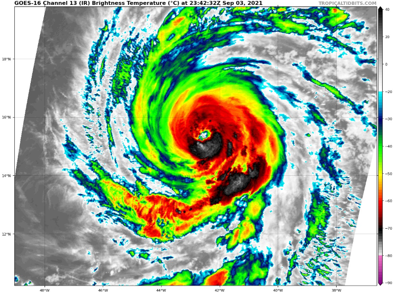
This looks to be making a run for a Cat 3 before the outer eyewall takes over. >-20C patches are appearing in the eye again, and convection is becoming deeper and more symmetrical. It probably won’t become a Cat 4 before that huge outer eyewall starts an EWRC, though.
0 likes
Irene '11 Sandy '12 Hermine '16 5/15/2018 Derecho Fay '20 Isaias '20 Elsa '21 Henri '21 Ida '21
I am only a meteorology enthusiast who knows a decent amount about tropical cyclones. Look to the professional mets, the NHC, or your local weather office for the best information.
I am only a meteorology enthusiast who knows a decent amount about tropical cyclones. Look to the professional mets, the NHC, or your local weather office for the best information.


Re: ATL: LARRY - Hurricane - Discussion
Larry's little alien friend :

Ida's Deadly Smile :


Ida's Deadly Smile :
1 likes
Once I see the REDS and GREENS Converge on a Base Velocity. ... I'm There!!
This is NOT an Official Forecast....Just my Opinion. For official information, please refer to the NHC and NWS products.
HIGHLIGHTS : '13 El Reno Tornado : 2013 Storm Chaser Tour, Joaquin; SC flood event, Matthew '16, Lowcountry Snow storm Jan '18
This is NOT an Official Forecast....Just my Opinion. For official information, please refer to the NHC and NWS products.
HIGHLIGHTS : '13 El Reno Tornado : 2013 Storm Chaser Tour, Joaquin; SC flood event, Matthew '16, Lowcountry Snow storm Jan '18
-
Iceresistance

- Category 5
- Posts: 9592
- Age: 22
- Joined: Sat Oct 10, 2020 9:45 am
- Location: Tecumseh, OK/Norman, OK
Re: ATL: LARRY - Hurricane - Discussion
Kohlecane wrote:Larry's little alien friend :
https://s9.gifyu.com/images/TlyYYmHzm.jpg
Ida's Deadly Smile :
https://s9.gifyu.com/images/20210827_195620.th.jpg
Yeah, Ida had the evil smile over Cuba, maybe the feature this year is bizarre looking storms on Satellite . . .
Last edited by Iceresistance on Fri Sep 03, 2021 6:42 pm, edited 1 time in total.
0 likes
Bill 2015 & Beta 2020
Winter 2020-2021
All observations are in Tecumseh, OK unless otherwise noted.
Winter posts are focused mainly for Oklahoma & Texas.
Take any of my forecasts with a grain of salt, refer to the NWS, SPC, and NHC for official information
Never say Never with weather! Because ANYTHING is possible!
Winter 2020-2021
All observations are in Tecumseh, OK unless otherwise noted.
Winter posts are focused mainly for Oklahoma & Texas.
Take any of my forecasts with a grain of salt, refer to the NWS, SPC, and NHC for official information
Never say Never with weather! Because ANYTHING is possible!

Re: ATL: LARRY - Hurricane - Discussion
SATCON now at 103kt.
AMSU - 108kt.
SSMIS - 104kt.
ADT - T5.3.
Seems quite likely we see Major Hurricane Larry at 11PM.
AMSU - 108kt.
SSMIS - 104kt.
ADT - T5.3.
Seems quite likely we see Major Hurricane Larry at 11PM.
3 likes
Kendall -> SLO -> PBC
Memorable Storms: Katrina (for its Florida landfall...) Wilma Matthew Irma
Memorable Storms: Katrina (for its Florida landfall...) Wilma Matthew Irma
-
cycloneye
- Admin
- Posts: 149511
- Age: 69
- Joined: Thu Oct 10, 2002 10:54 am
- Location: San Juan, Puerto Rico
Re: ATL: LARRY - Hurricane - Discussion
0 likes
Visit the Caribbean-Central America Weather Thread where you can find at first post web cams,radars
and observations from Caribbean basin members Click Here
and observations from Caribbean basin members Click Here
Re: ATL: LARRY - Hurricane - Discussion
Ubuntwo wrote:SATCON now at 103kt.
AMSU - 108kt.
SSMIS - 104kt.
ADT - T5.3.
Seems quite likely we see Major Hurricane Ida at 11PM.
Oh please no not again
0 likes
Irene '11 Sandy '12 Hermine '16 5/15/2018 Derecho Fay '20 Isaias '20 Elsa '21 Henri '21 Ida '21
I am only a meteorology enthusiast who knows a decent amount about tropical cyclones. Look to the professional mets, the NHC, or your local weather office for the best information.
I am only a meteorology enthusiast who knows a decent amount about tropical cyclones. Look to the professional mets, the NHC, or your local weather office for the best information.
-
Iceresistance
- Category 5
- Posts: 9592
- Age: 22
- Joined: Sat Oct 10, 2020 9:45 am
- Location: Tecumseh, OK/Norman, OK
Re: ATL: LARRY - Hurricane - Discussion
Ubuntwo wrote:SATCON now at 103kt.
AMSU - 108kt.
SSMIS - 104kt.
ADT - T5.3.
Seems quite likely we see Major Hurricane Ida at 11PM.
Do you mean Larry?
0 likes
Bill 2015 & Beta 2020
Winter 2020-2021
All observations are in Tecumseh, OK unless otherwise noted.
Winter posts are focused mainly for Oklahoma & Texas.
Take any of my forecasts with a grain of salt, refer to the NWS, SPC, and NHC for official information
Never say Never with weather! Because ANYTHING is possible!
Winter 2020-2021
All observations are in Tecumseh, OK unless otherwise noted.
Winter posts are focused mainly for Oklahoma & Texas.
Take any of my forecasts with a grain of salt, refer to the NWS, SPC, and NHC for official information
Never say Never with weather! Because ANYTHING is possible!
-
cycloneye
- Admin
- Posts: 149511
- Age: 69
- Joined: Thu Oct 10, 2002 10:54 am
- Location: San Juan, Puerto Rico
Re: ATL: LARRY - Hurricane - Discussion
Fixed it for Ubuntwo.
3 likes
Visit the Caribbean-Central America Weather Thread where you can find at first post web cams,radars
and observations from Caribbean basin members Click Here
and observations from Caribbean basin members Click Here
-
Stormybajan
- Category 1
- Posts: 453
- Joined: Thu May 20, 2021 3:21 pm
- Location: Windward Islands
Re: ATL: LARRY - Hurricane - Discussion
Easily a 115 mph Hurricane now, however I dont see the nhc taking a 15 mph jump. Calling for 110 mph at 11.
1 likes
Sad West Indies and Manchester United fan ⚽️
Re: ATL: LARRY - Hurricane - Discussion
Iceresistance wrote:Ubuntwo wrote:SATCON now at 103kt.
AMSU - 108kt.
SSMIS - 104kt.
ADT - T5.3.
Seems quite likely we see Major Hurricane Ida at 11PM.
Do you mean Larry?
Whoopsies
0 likes
Kendall -> SLO -> PBC
Memorable Storms: Katrina (for its Florida landfall...) Wilma Matthew Irma
Memorable Storms: Katrina (for its Florida landfall...) Wilma Matthew Irma
Re: ATL: LARRY - Hurricane - Discussion
Stormybajan wrote:https://i.postimg.cc/hPzSFp8G/Hurricane-Larry-Sep321-R.png
Easily a 115 mph Hurricane now, however I dont see the nhc taking a 15 mph jump. Calling for 110 mph at 11.
They could’ve if they did a special advisory at 8pm to put this at 90-95 kt before going with 100 kt at 11pm. However, there is no special advisory. If satellite estimates are all over 100 kt, they’ll have no choice to go with a major at 11.
3 likes
Irene '11 Sandy '12 Hermine '16 5/15/2018 Derecho Fay '20 Isaias '20 Elsa '21 Henri '21 Ida '21
I am only a meteorology enthusiast who knows a decent amount about tropical cyclones. Look to the professional mets, the NHC, or your local weather office for the best information.
I am only a meteorology enthusiast who knows a decent amount about tropical cyclones. Look to the professional mets, the NHC, or your local weather office for the best information.
Who is online
Users browsing this forum: No registered users and 29 guests