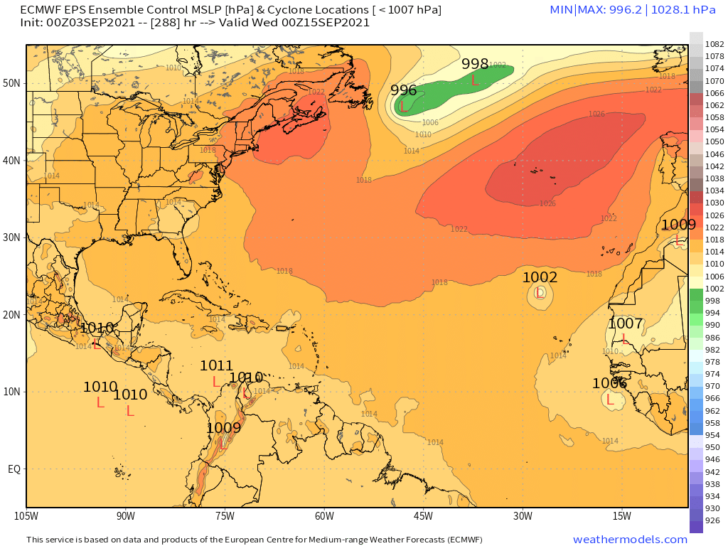
2021 Indicators: SST's / SAL / MSLP / Shear / Steering / Instability / Sat Images

This is the general tropical discussion area. Anyone can take their shot at predicting a storms path.

Moderator: S2k Moderators

Forum rules

The posts in this forum are NOT official forecasts and should not be used as such. They are just the opinion of the poster and may or may not be backed by sound meteorological data. They are NOT endorsed by any professional institution or STORM2K. For official information, please refer to products from the National Hurricane Center and National Weather Service.

Help Support Storm2K
Message
Author
AlphaToOmega
Category 5
Category 5
Posts: 1448
Joined: Sat Jun 26, 2021 10:51 am
Location: Somewhere in Massachusetts

Re: 2021 Indicators: SST's / SAL / MSLP / Shear / Steering / Instability / Sat Images

#3021 Postby AlphaToOmega » Fri Sep 03, 2021 5:38 am

Hammy wrote:Recent CFS runs seem to indicate a quiet period, possibly little to nothing new forming for the rest of early to mid-September, at least over the Atlantic ocean itself--something it's been hinting at since July (unfortunately the GoM/Caribbean maps are still having issues loading) but it's showing another burst of activity the last third of September, and continues to show the MDR producing storms into October, with varying intensity from run to run.

What maps are you looking at? The VP maps certainly show a favorable pattern for all of September.
0 likes   

User avatar
aspen
Category 5
Category 5
Posts: 8818
Joined: Sat Oct 12, 2019 7:10 pm
Location: Connecticut, USA

Re: 2021 Indicators: SST's / SAL / MSLP / Shear / Steering / Instability / Sat Images

#3022 Postby aspen » Fri Sep 03, 2021 6:04 am

Hammy wrote:Recent CFS runs seem to indicate a quiet period, possibly little to nothing new forming for the rest of early to mid-September, at least over the Atlantic ocean itself--something it's been hinting at since July (unfortunately the GoM/Caribbean maps are still having issues loading) but it's showing another burst of activity the last third of September, and continues to show the MDR producing storms into October, with varying intensity from run to run.

While the CFS did sniff out Ida a month in advance, it either missed or overhyped many other systems. What has remained constant over the last several weeks is the potential for at least one more big MDR long-tracker in September after Larry. Weaker systems, or those in the GoM/Caribbean, are likely being missed, although the most recent CFS run does suggest there could be 2 weaker MDR systems in September alongside a second long-tracker.
0 likes   
Irene '11 Sandy '12 Hermine '16 5/15/2018 Derecho Fay '20 Isaias '20 Elsa '21 Henri '21 Ida '21

I am only a meteorology enthusiast who knows a decent amount about tropical cyclones. Look to the professional mets, the NHC, or your local weather office for the best information.

User avatar
Category5Kaiju
Category 5
Category 5
Posts: 4097
Joined: Thu Dec 24, 2020 12:45 pm
Location: Seattle

Re: 2021 Indicators: SST's / SAL / MSLP / Shear / Steering / Instability / Sat Images

#3023 Postby Category5Kaiju » Fri Sep 03, 2021 6:10 am

aspen wrote:
Hammy wrote:Recent CFS runs seem to indicate a quiet period, possibly little to nothing new forming for the rest of early to mid-September, at least over the Atlantic ocean itself--something it's been hinting at since July (unfortunately the GoM/Caribbean maps are still having issues loading) but it's showing another burst of activity the last third of September, and continues to show the MDR producing storms into October, with varying intensity from run to run.

While the CFS did sniff out Ida a month in advance, it either missed or overhyped many other systems. What has remained constant over the last several weeks is the potential for at least one more big MDR long-tracker in September after Larry. Weaker systems, or those in the GoM/Caribbean, are likely being missed, although the most recent CFS run does suggest there could be 2 weaker MDR systems in September alongside a second long-tracker.


Whatever the case, I personally expect to see at least 4 or 5 more NSs this month. At the pace we are currently at, we will very likely reach Wanda before the season's end.
0 likes   
Unless explicitly stated, all info in my posts is based on my own opinions and observations. Tropical storms and hurricanes can be extremely dangerous. Do not think you can beat Mother Nature. Refer to an accredited weather research agency or meteorologist if you need to make serious decisions regarding an approaching storm.

User avatar
SFLcane
S2K Supporter
S2K Supporter
Posts: 10163
Age: 47
Joined: Sat Jun 05, 2010 1:44 pm
Location: Lake Worth Florida

Re: 2021 Indicators: SST's / SAL / MSLP / Shear / Steering / Instability / Sat Images

#3024 Postby SFLcane » Fri Sep 03, 2021 6:42 am

Phil k is predicting Above normal activity next 2 weeks.
0 likes   

User avatar
SFLcane
S2K Supporter
S2K Supporter
Posts: 10163
Age: 47
Joined: Sat Jun 05, 2010 1:44 pm
Location: Lake Worth Florida

Re: 2021 Indicators: SST's / SAL / MSLP / Shear / Steering / Instability / Sat Images

#3025 Postby SFLcane » Fri Sep 03, 2021 9:07 am

2 likes   

JPmia
S2K Supporter
S2K Supporter
Posts: 1070
Joined: Thu Jun 03, 2004 11:01 pm
Location: Fort Lauderdale, FL

Re: 2021 Indicators: SST's / SAL / MSLP / Shear / Steering / Instability / Sat Images

#3026 Postby JPmia » Fri Sep 03, 2021 9:21 am

gatorcane wrote:Seems like a taste of fall for the eastern CONUS on the GFS with 60s down to the northern Gulf coast which is below normal if it verifies. Indicator of the fall pattern coming early this year and winding down the season for the CONUS early? (Wistful thinking)

https://i.postimg.cc/gJfxcFSB/gfs-T2m-us-fh132-216.gif


Perhaps, but that's not reassuring to the East Gulf and Floridians.. I don't need to tell you what happens in October Gatorcane :wink:
0 likes   

User avatar
SFLcane
S2K Supporter
S2K Supporter
Posts: 10163
Age: 47
Joined: Sat Jun 05, 2010 1:44 pm
Location: Lake Worth Florida

Re: 2021 Indicators: SST's / SAL / MSLP / Shear / Steering / Instability / Sat Images

#3027 Postby SFLcane » Fri Sep 03, 2021 9:23 am

This is why I am starting to get really concerned here if something is there. For example here is the eps control and look at the steering! Yep :crazyeyes: :crazyeyes:

Image

Image
3 likes   

Shell Mound
Category 5
Category 5
Posts: 2434
Age: 32
Joined: Thu Sep 07, 2017 3:39 pm
Location: St. Petersburg, FL → Scandinavia

Re: 2021 Indicators: SST's / SAL / MSLP / Shear / Steering / Instability / Sat Images

#3028 Postby Shell Mound » Fri Sep 03, 2021 9:36 am

SFLcane wrote:This is why I am starting to get really concerned here if something is there. For example here is the eps control and look at the steering! Yep :crazyeyes: :crazyeyes:

https://i.postimg.cc/dtKdjsWJ/0306-A624-FF6-C-4851-8103-9-C237-F4-D6-CFF.gif

https://i.postimg.cc/LshZ8ns3/A2-E75-D5-A-9651-4-D5-B-9-BB0-246-E3-DD8-A5-E7.jpg

That TC would affect the CONUS after 20 September. Very few CV systems have hit the CONUS after that date. The Islands, including the Bahamas, would still need to monitor any potential CV TC, but the date is extremely late for a CV LF on the CONUS. There have been exceptions such as October 1893, Hugo, and Georges, but those were quite anomalous. For a CV TC to affect the CONUS on or before 20 September, it would need to form no later than 13 September, assuming a week-long passage.
0 likes   
CVW / MiamiensisWx / Shell Mound
The posts in this forum are NOT official forecasts and should not be used as such. They are just the opinion of the poster and may or may not be backed by sound meteorological data. They are NOT endorsed by any professional institution or STORM2K. For official information, please refer to products from the NHC and NWS.

User avatar
Hammy
Category 5
Category 5
Posts: 5849
Age: 41
Joined: Fri May 25, 2012 5:25 pm
Contact:

Re: 2021 Indicators: SST's / SAL / MSLP / Shear / Steering / Instability / Sat Images

#3029 Postby Hammy » Fri Sep 03, 2021 1:35 pm

aspen wrote:
Hammy wrote:Recent CFS runs seem to indicate a quiet period, possibly little to nothing new forming for the rest of early to mid-September, at least over the Atlantic ocean itself--something it's been hinting at since July (unfortunately the GoM/Caribbean maps are still having issues loading) but it's showing another burst of activity the last third of September, and continues to show the MDR producing storms into October, with varying intensity from run to run.

While the CFS did sniff out Ida a month in advance, it either missed or overhyped many other systems. What has remained constant over the last several weeks is the potential for at least one more big MDR long-tracker in September after Larry. Weaker systems, or those in the GoM/Caribbean, are likely being missed, although the most recent CFS run does suggest there could be 2 weaker MDR systems in September alongside a second long-tracker.


I think part of what happened, and it showed up on the shorter range models as well, that the system behind Larry simply didn't find favorable conditions--in part because of Larry itself--that the models had otherwise shown.

As far as the Gulf and western Caribbean their site is buggy so I don't have access to those maps on a consistent enough basis to see any trends, so I'm going purely on the MDR and central/western Atlantic.

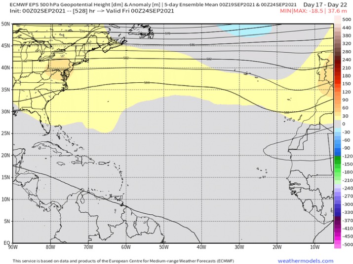
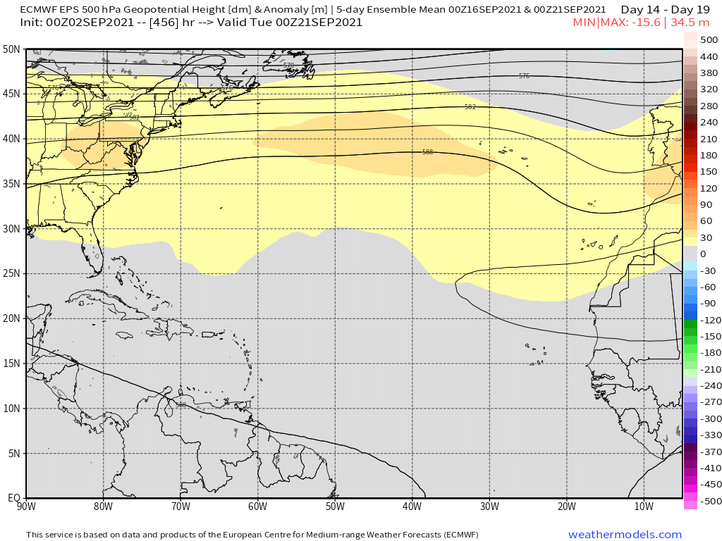
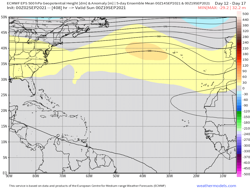
The rainfall maps do seem to verify what the extended range surface maps show, that there could be a lull in new storms until after the 15th with a second peak after that, something that doesn't seem uncommon in months with active Augusts.


Image

Image
1 likes   
The above post is not official and should not be used as such. It is the opinion of the poster and may or may not be backed by sound meteorological data. It is not endorsed by any professional institution or storm2k.org. For official information, please refer to the NHC and NWS products.

AlphaToOmega
Category 5
Category 5
Posts: 1448
Joined: Sat Jun 26, 2021 10:51 am
Location: Somewhere in Massachusetts

Re: 2021 Indicators: SST's / SAL / MSLP / Shear / Steering / Instability / Sat Images

#3030 Postby AlphaToOmega » Fri Sep 03, 2021 1:53 pm

Category5Kaiju wrote:
aspen wrote:
Hammy wrote:Recent CFS runs seem to indicate a quiet period, possibly little to nothing new forming for the rest of early to mid-September, at least over the Atlantic ocean itself--something it's been hinting at since July (unfortunately the GoM/Caribbean maps are still having issues loading) but it's showing another burst of activity the last third of September, and continues to show the MDR producing storms into October, with varying intensity from run to run.

While the CFS did sniff out Ida a month in advance, it either missed or overhyped many other systems. What has remained constant over the last several weeks is the potential for at least one more big MDR long-tracker in September after Larry. Weaker systems, or those in the GoM/Caribbean, are likely being missed, although the most recent CFS run does suggest there could be 2 weaker MDR systems in September alongside a second long-tracker.


Whatever the case, I personally expect to see at least 4 or 5 more NSs this month. At the pace we are currently at, we will very likely reach Wanda before the season's end.


I could see many more. 4 or 5 more storms is month is quite conservative in my opinion; 2018 and 2019 had 7, and 2020 had 10. Reaching Wanda before the end of the season seems likely.
1 likes   

User avatar
CyclonicFury
Category 5
Category 5
Posts: 2025
Age: 26
Joined: Sun Jul 02, 2017 12:32 pm
Location: NC
Contact:

Re: 2021 Indicators: SST's / SAL / MSLP / Shear / Steering / Instability / Sat Images

#3031 Postby CyclonicFury » Fri Sep 03, 2021 8:24 pm

Date of 3rd major of the season of all Atlantic hurricane seasons (UTC) with 3+ majors since 1995:

1995: September 17 (5 total majors)
1996: September 4 (6 total majors)
1998: October 25 (3 total majors)
1999: September 12 (5 total majors)
2000: October 1 (3 total majors)
2001: October 8 (4 total majors)
2003: October 3 (3 total majors)
2004: August 27 (6 total majors)
2005: August 27 (7 total majors)
2008: September 3 (5 total majors)
2010: September 12 (5 total majors)
2011: September 30 (4 total majors)
2016: October 12 (4 total majors)
2017: September 7 (6 total majors)
2019: September 26 (3 total majors)
2020: October 6 (7 total majors)

Since the current active era of Atlantic hurricane activity began in 1995, assuming NHC goes with the 00z best track, 2021 will have its third major hurricane earlier than each season except 2004, 2005, and 2008. Even 2017 and 2020 had its third major at a later date (with 2020 in particular having only 2 major hurricanes before October). It seems possible the Atlantic could end up with 5-6 major hurricanes this year, especially if the late season features some intense hurricanes once again.
5 likes   
NCSU B.S. in Meteorology Class of 2021. Tropical weather blogger at http://www.cyclonicfury.com. My forecasts and thoughts are NOT official, for official forecasts please consult the National Hurricane Center.

AlphaToOmega
Category 5
Category 5
Posts: 1448
Joined: Sat Jun 26, 2021 10:51 am
Location: Somewhere in Massachusetts

Re: 2021 Indicators: SST's / SAL / MSLP / Shear / Steering / Instability / Sat Images

#3032 Postby AlphaToOmega » Fri Sep 03, 2021 8:37 pm

So far, 2021 seems to have elements of 2020, 2017, and 2005. It is featuring activity at the rate of 2020 and 2005. It is featuring MDR activity at the rate of 2017. It is bullying Louisiana like 2020 and 2005.
4 likes   

User avatar
Category5Kaiju
Category 5
Category 5
Posts: 4097
Joined: Thu Dec 24, 2020 12:45 pm
Location: Seattle

Re: 2021 Indicators: SST's / SAL / MSLP / Shear / Steering / Instability / Sat Images

#3033 Postby Category5Kaiju » Fri Sep 03, 2021 8:42 pm

AlphaToOmega wrote:So far, 2021 seems to have elements of 2020, 2017, and 2005. It is featuring activity at the rate of 2020 and 2005. It is featuring MDR activity at the rate of 2017. It is bullying Louisiana like 2020 and 2005.


It also feels like we are getting major hurricanes earlier and more readily than 2020; for some reason last year felt a bit sluggish (of course, until October) as while we had Laura and Teddy, the vast number of other storms were relatively weak or short-lived. This year seems to have quality for August and September so far, and quantity is not bad either; we are currently only one named storm behind 2005's pace.
0 likes   
Unless explicitly stated, all info in my posts is based on my own opinions and observations. Tropical storms and hurricanes can be extremely dangerous. Do not think you can beat Mother Nature. Refer to an accredited weather research agency or meteorologist if you need to make serious decisions regarding an approaching storm.

User avatar
CyclonicFury
Category 5
Category 5
Posts: 2025
Age: 26
Joined: Sun Jul 02, 2017 12:32 pm
Location: NC
Contact:

Re: 2021 Indicators: SST's / SAL / MSLP / Shear / Steering / Instability / Sat Images

#3034 Postby CyclonicFury » Fri Sep 03, 2021 8:48 pm

I think it's also interesting to note that 4 of the 5 hurricanes became hurricanes in the deep tropics south of 20°N. The deep tropics have been quite active thus far, in contrast to what some were anticipating.
9 likes   
NCSU B.S. in Meteorology Class of 2021. Tropical weather blogger at http://www.cyclonicfury.com. My forecasts and thoughts are NOT official, for official forecasts please consult the National Hurricane Center.

User avatar
Category5Kaiju
Category 5
Category 5
Posts: 4097
Joined: Thu Dec 24, 2020 12:45 pm
Location: Seattle

Re: 2021 Indicators: SST's / SAL / MSLP / Shear / Steering / Instability / Sat Images

#3035 Postby Category5Kaiju » Fri Sep 03, 2021 10:04 pm

 https://twitter.com/philklotzbach/status/1433983191375695876


At this point I would be shocked if we do not end up with a hyperactive season.
0 likes   
Unless explicitly stated, all info in my posts is based on my own opinions and observations. Tropical storms and hurricanes can be extremely dangerous. Do not think you can beat Mother Nature. Refer to an accredited weather research agency or meteorologist if you need to make serious decisions regarding an approaching storm.

User avatar
galaxy401
Category 5
Category 5
Posts: 2419
Age: 30
Joined: Sat Aug 25, 2012 9:04 pm
Location: Casa Grande, Arizona

Re: 2021 Indicators: SST's / SAL / MSLP / Shear / Steering / Instability / Sat Images

#3036 Postby galaxy401 » Fri Sep 03, 2021 10:20 pm

Crazy looking at that list that 2020 didn't have its third Major until early October, yet it still produced 4 more Majors. Really showed how hyperactive October and November were.
0 likes   
Got my eyes on moving right into Hurricane Alley: Florida.

User avatar
weeniepatrol
Category 5
Category 5
Posts: 1276
Joined: Sat Aug 22, 2020 5:30 pm
Location: WA State

Re: 2021 Indicators: SST's / SAL / MSLP / Shear / Steering / Instability / Sat Images

#3037 Postby weeniepatrol » Fri Sep 03, 2021 11:18 pm

1 likes   

User avatar
Steve
S2K Supporter
S2K Supporter
Posts: 9621
Joined: Sat Apr 05, 2003 11:41 pm
Location: Not a state-caster

Re: 2021 Indicators: SST's / SAL / MSLP / Shear / Steering / Instability / Sat Images

#3038 Postby Steve » Fri Sep 03, 2021 11:36 pm

gatorcane wrote:Seems like a taste of fall for the eastern CONUS on the GFS with 60s down to the northern Gulf coast which is below normal if it verifies. Indicator of the fall pattern coming early this year and winding down the season for the CONUS early? (Wistful thinking)

https://i.postimg.cc/gJfxcFSB/gfs-T2m-us-fh132-216.gif


I feel like it’s been the other way the last couple of decades. Fronts coming down often signaled a tropical response to the amplification.
1 likes   

AlphaToOmega
Category 5
Category 5
Posts: 1448
Joined: Sat Jun 26, 2021 10:51 am
Location: Somewhere in Massachusetts

Re: 2021 Indicators: SST's / SAL / MSLP / Shear / Steering / Instability / Sat Images

#3039 Postby AlphaToOmega » Sat Sep 04, 2021 8:08 am

Steve wrote:
gatorcane wrote:Seems like a taste of fall for the eastern CONUS on the GFS with 60s down to the northern Gulf coast which is below normal if it verifies. Indicator of the fall pattern coming early this year and winding down the season for the CONUS early? (Wistful thinking)

https://i.postimg.cc/gJfxcFSB/gfs-T2m-us-fh132-216.gif


I feel like it’s been the other way the last couple of decades. Fronts coming down often signaled a tropical response to the amplification.


It is also important to note that frontal boundaries can create tropical cyclones.
1 likes   

User avatar
SFLcane
S2K Supporter
S2K Supporter
Posts: 10163
Age: 47
Joined: Sat Jun 05, 2010 1:44 pm
Location: Lake Worth Florida

Re: 2021 Indicators: SST's / SAL / MSLP / Shear / Steering / Instability / Sat Images

#3040 Postby SFLcane » Sat Sep 04, 2021 9:38 am

Almost like a mid August look but in mid September. :eek:

Image

Image
0 likes   


Return to “Talkin' Tropics”

Who is online

Users browsing this forum: Blinhart, JtSmarts, southmdwatcher and 59 guests