ATL: LARRY - Post-Tropical - Discussion

Moderator: S2k Moderators

Message
Author
User avatar
Yellow Evan
Professional-Met
Professional-Met
Posts: 16143
Age: 27
Joined: Fri Jul 15, 2011 12:48 pm
Location: Henderson, Nevada/Honolulu, HI
Contact:

Re: ATL: LARRY - Hurricane - Discussion

#521 Postby Yellow Evan » Sun Sep 05, 2021 8:19 am

Kingarabian wrote:
kevin wrote:
Kingarabian wrote:
* GFS version *
* ATLANTIC 2021 SHIPS INTENSITY FORECAST *
* IR SAT DATA AVAILABLE, OHC AVAILABLE *
* LARRY AL122021 09/05/21 06 UTC *

TIME (HR) 0 6 12 18 24 36 48 60 72 84 96 108 120 132 144 156 168
V (KT) NO LAND 105 103 102 100 99 95 95 94 96 99 99 101 95 90 85 72 52
V (KT) LAND 105 103 102 100 99 95 95 94 96 99 99 101 95 90 85 72 52
V (KT) LGEM 105 102 99 97 96 94 95 99 103 105 105 101 94 88 69 53 45
Storm Type TROP TROP TROP TROP TROP TROP TROP TROP TROP TROP TROP TROP TROP TROP EXTP EXTP EXTP

SHEAR (KT) 8 9 9 11 9 6 7 7 9 7 5 12 18 20 34 25 38
SHEAR ADJ (KT) 0 -2 -1 -1 2 3 3 2 -3 0 1 -1 -1 10 10 -1 7
SHEAR DIR 252 252 254 261 277 291 271 283 283 192 137 188 223 223 209 182 202
SST (C) 27.5 27.6 27.8 27.9 27.9 28.0 29.1 29.2 29.5 29.3 29.0 28.2 27.8 25.2 17.5 13.1 11.0


This hasn't peaked at all. More to come. This has all the ingredients to get to Cat.5. Recon should also be in around its peak just incase Dvorak pulls a choke job.


Do you also have the the shear forecast according to the Euro? Since the NHC discussion mentions that GFS and the euro still differ quite a bit in terms of their shear forecast during the next 48 hours (where euro shows more shear).

Very similar shear from what I can see. Could argue the Euro has less shear over the next 48 hours compared to the GFS. The Euro is more bullish on this compared to the GFS.

GFS:
https://i.postimg.cc/vZj8Trk8/image.png

Euro:
https://i.postimg.cc/qvt0PtRP/image.png


Sorta. Notice how on the ECMWF TUTT is stronger, which is likely to induce southwesterly shear and based on the streamlines that surround the storm, the ULAC is likely of similar intensity, maybe the ECMWF has a stronger ULAC. Nevertheless, the storm may be strong enough to fight off the TUTT.
Last edited by Yellow Evan on Sun Sep 05, 2021 8:24 am, edited 1 time in total.
0 likes   

User avatar
Yellow Evan
Professional-Met
Professional-Met
Posts: 16143
Age: 27
Joined: Fri Jul 15, 2011 12:48 pm
Location: Henderson, Nevada/Honolulu, HI
Contact:

Re: ATL: LARRY - Hurricane - Discussion

#522 Postby Yellow Evan » Sun Sep 05, 2021 8:21 am

aspen wrote:It almost seems like another EWRC might be starting, based on that weird gap in the NW quadrant. I don’t know how the eye can get any bigger.


This is the last storm that you will see ERC due to its large eye and CDO dominant core.
0 likes   

User avatar
Kazmit
Category 5
Category 5
Posts: 2124
Age: 22
Joined: Mon Jul 25, 2016 8:49 am
Location: Williamsburg, VA / Bermuda

Re: ATL: LARRY - Hurricane - Discussion

#523 Postby Kazmit » Sun Sep 05, 2021 8:37 am

Image
4 likes   
Igor 2010, Sandy 2012, Fay 2014, Gonzalo 2014, Joaquin 2015, Nicole 2016, Humberto 2019

I am only a tropical weather enthusiast. My predictions are not official and may or may not be backed by sound meteorological data. For official information, please refer to the NHC and NWS products.

TheBigO
Tropical Low
Tropical Low
Posts: 36
Joined: Wed Sep 06, 2017 9:39 pm
Location: Orlando, FL metro

Re: ATL: LARRY - Hurricane - Discussion

#524 Postby TheBigO » Sun Sep 05, 2021 9:08 am

Is Larry now considered annular?
0 likes   

User avatar
aspen
Category 5
Category 5
Posts: 8818
Joined: Sat Oct 12, 2019 7:10 pm
Location: Connecticut, USA

Re: ATL: LARRY - Hurricane - Discussion

#525 Postby aspen » Sun Sep 05, 2021 9:22 am

Looking a lot more ragged now. Like, maybe-not-a-major-anymore kind of tagged. I think the NHC said in yesterday’s 5pm advisory that shear was supposed to peak today, so that might be the cause.

The degradation since the best track was updated might mean the NHC will stick with 105 kt and not go with 110 kt/955 mb
0 likes   
Irene '11 Sandy '12 Hermine '16 5/15/2018 Derecho Fay '20 Isaias '20 Elsa '21 Henri '21 Ida '21

I am only a meteorology enthusiast who knows a decent amount about tropical cyclones. Look to the professional mets, the NHC, or your local weather office for the best information.

User avatar
TorSkk
Category 2
Category 2
Posts: 514
Joined: Thu Jul 05, 2018 5:08 am

Re: ATL: LARRY - Hurricane - Discussion

#526 Postby TorSkk » Sun Sep 05, 2021 9:47 am

Hurricane Larry Advisory Number 20
NWS National Hurricane Center Miami FL AL122021
1100 AM AST Sun Sep 05 2021

...LARRY EXPECTED TO CAUSE DANGEROUS SURF AND RIP CURRENTS ALONG THE
WESTERN ATLANTIC SHORES LATER THIS WEEK...


SUMMARY OF 1100 AM AST...1500 UTC...INFORMATION
-----------------------------------------------
LOCATION...19.5N 49.7W
ABOUT 880 MI...1415 KM E OF THE NORTHERN LEEWARD ISLANDS
ABOUT 1285 MI...2070 KM SE OF BERMUDA
MAXIMUM SUSTAINED WINDS...125 MPH...205 KM/H
PRESENT MOVEMENT...NW OR 310 DEGREES AT 13 MPH...20 KM/H
MINIMUM CENTRAL PRESSURE...955 MB...28.20 INCHES
0 likes   

User avatar
TheDreamTraveler
Category 2
Category 2
Posts: 641
Joined: Sun Aug 22, 2010 3:10 am
Location: PA

Re: ATL: LARRY - Hurricane - Discussion

#527 Postby TheDreamTraveler » Sun Sep 05, 2021 9:58 am

kevin wrote:Almost a perfectly circular eye, Dvorak should like this.

https://i.imgur.com/d2fm2tB.jpg


That eye is a monster
0 likes   

User avatar
Cyclenall
Category 5
Category 5
Posts: 6666
Joined: Thu Jun 08, 2006 10:01 pm
Location: Ontario, Canada

Re: ATL: LARRY - Hurricane - Discussion

#528 Postby Cyclenall » Sun Sep 05, 2021 10:24 am

supercane4867 wrote:With the ongoing symmetrization, 115-120kt peak by tomorrow seems reasonable

https://i.imgur.com/GkPC3SR.gif

What is going on with Larry's banding on the far left? Its like convection fill-in rather than outflow.
0 likes   

User avatar
abajan
S2K Supporter
S2K Supporter
Posts: 4230
Joined: Sun Sep 07, 2003 5:10 am
Location: Barbados

Re: ATL: LARRY - Hurricane - Discussion

#529 Postby abajan » Sun Sep 05, 2021 10:48 am

Hypercane_Kyle wrote:https://i.imgur.com/8vav6Zo.jpg

As cheezyWXguy has stated, it does look tilted to the east with height. Hmm
0 likes   

User avatar
Stormybajan
Category 1
Category 1
Posts: 448
Joined: Thu May 20, 2021 3:21 pm
Location: Windward Islands

Re: ATL: LARRY - Hurricane - Discussion

#530 Postby Stormybajan » Sun Sep 05, 2021 11:24 am

Image
Will Larry become the first Doubled-Eyed Hurricane? :lol: :lol:
1 likes   
Sad West Indies and Manchester United fan ⚽️

sikkar
Category 1
Category 1
Posts: 326
Joined: Sun Aug 26, 2012 1:44 am
Location: Florida

Re: ATL: LARRY - Hurricane - Discussion

#531 Postby sikkar » Sun Sep 05, 2021 11:43 am

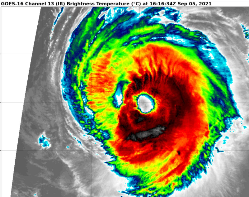
Looks like it's trying to form a gigantic eye since the western eyewall is eroding quickly.
0 likes   

Shell Mound
Category 5
Category 5
Posts: 2434
Age: 32
Joined: Thu Sep 07, 2017 3:39 pm
Location: St. Petersburg, FL → Scandinavia

Re: ATL: LARRY - Hurricane - Discussion

#532 Postby Shell Mound » Sun Sep 05, 2021 11:49 am

Stormybajan wrote:https://i.postimg.cc/HnpLg1T8/Hurricane-Larry-Sep521-R.png
Will Larry become the first Doubled-Eyed Hurricane? :lol: :lol:

Wilma (2005) exhibited a similar dry slot while east of the Southeastern CONUS, over the Gulf Stream.
1 likes   
CVW / MiamiensisWx / Shell Mound
The posts in this forum are NOT official forecasts and should not be used as such. They are just the opinion of the poster and may or may not be backed by sound meteorological data. They are NOT endorsed by any professional institution or STORM2K. For official information, please refer to products from the NHC and NWS.

User avatar
kevin
Category 5
Category 5
Posts: 2586
Age: 26
Joined: Wed Aug 28, 2019 4:35 am

Re: ATL: LARRY - Hurricane - Discussion

#533 Postby kevin » Sun Sep 05, 2021 11:50 am

Stormybajan wrote:https://i.postimg.cc/HnpLg1T8/Hurricane-Larry-Sep521-R.png
Will Larry become the first Doubled-Eyed Hurricane? :lol: :lol:


It almost looks like it's cloning itself :lol:. Realistically though it might be trying to form an even larger eye.
0 likes   

User avatar
aspen
Category 5
Category 5
Posts: 8818
Joined: Sat Oct 12, 2019 7:10 pm
Location: Connecticut, USA

Re: ATL: LARRY - Hurricane - Discussion

#534 Postby aspen » Sun Sep 05, 2021 11:55 am

Eye temps are warming, and convection has become very ragged. Larry appears to be weakening for some reason, but without a recent microwave pass, it’s impossible to tell if it’s due to mid-level dry air, shear, or an attempt to make a 100-mile wide eye.
0 likes   
Irene '11 Sandy '12 Hermine '16 5/15/2018 Derecho Fay '20 Isaias '20 Elsa '21 Henri '21 Ida '21

I am only a meteorology enthusiast who knows a decent amount about tropical cyclones. Look to the professional mets, the NHC, or your local weather office for the best information.

Sciencerocks
Category 5
Category 5
Posts: 9155
Age: 39
Joined: Thu Jul 06, 2017 1:51 am

Re: ATL: LARRY - Hurricane - Discussion

#535 Postby Sciencerocks » Sun Sep 05, 2021 11:59 am

Image
3 likes   

User avatar
cheezyWXguy
Category 5
Category 5
Posts: 6108
Joined: Mon Feb 13, 2006 12:29 am
Location: Dallas, TX

Re: ATL: LARRY - Hurricane - Discussion

#536 Postby cheezyWXguy » Sun Sep 05, 2021 12:03 pm

Looks like shear out of the southwest to me. Only the NE tip of the surface eye is visible through the mid level eye. It’s obviously tilted.
0 likes   

User avatar
Yellow Evan
Professional-Met
Professional-Met
Posts: 16143
Age: 27
Joined: Fri Jul 15, 2011 12:48 pm
Location: Henderson, Nevada/Honolulu, HI
Contact:

Re: ATL: LARRY - Hurricane - Discussion

#537 Postby Yellow Evan » Sun Sep 05, 2021 12:18 pm

Larry will probably re-deepen again at Dmax like most hurricanes over marginal waters do.
0 likes   

User avatar
aspen
Category 5
Category 5
Posts: 8818
Joined: Sat Oct 12, 2019 7:10 pm
Location: Connecticut, USA

Re: ATL: LARRY - Hurricane - Discussion

#538 Postby aspen » Sun Sep 05, 2021 12:41 pm

Six-hour recon fixes will begin on Wednesday as Larry nears Bermuda. Tuesday’s flight will depart at 12z and probably won’t arrive until after the 11AM advisory is issued, but if the upper level environment will be as favorable as the HWRF says, then Larry could be near or at peak intensity then.
3 likes   
Irene '11 Sandy '12 Hermine '16 5/15/2018 Derecho Fay '20 Isaias '20 Elsa '21 Henri '21 Ida '21

I am only a meteorology enthusiast who knows a decent amount about tropical cyclones. Look to the professional mets, the NHC, or your local weather office for the best information.

User avatar
Yellow Evan
Professional-Met
Professional-Met
Posts: 16143
Age: 27
Joined: Fri Jul 15, 2011 12:48 pm
Location: Henderson, Nevada/Honolulu, HI
Contact:

Re: ATL: LARRY - Hurricane - Discussion

#539 Postby Yellow Evan » Sun Sep 05, 2021 12:50 pm

Image

T5.5.
1 likes   

User avatar
cheezyWXguy
Category 5
Category 5
Posts: 6108
Joined: Mon Feb 13, 2006 12:29 am
Location: Dallas, TX

Re: ATL: LARRY - Hurricane - Discussion

#540 Postby cheezyWXguy » Sun Sep 05, 2021 12:54 pm


Would there be any subtractions from center not being in the middle of the apparent eye?
0 likes   


Return to “2021”

Who is online

Users browsing this forum: No registered users and 3 guests