
2021 Global Model Runs Discussion (Out thru day 16)
Moderator: S2k Moderators
Forum rules

The posts in this forum are NOT official forecasts and should not be used as such. They are just the opinion of the poster and may or may not be backed by sound meteorological data. They are NOT endorsed by any professional institution or STORM2K. For official information, please refer to products from the National Hurricane Center and National Weather Service.
-
Clearcloudz

- Category 2

- Posts: 540
- Joined: Sun Jun 10, 2018 1:46 pm
- Location: Rosenberg TX
Re: 2021 Global Model Runs Discussion (Out thru day 16)
18Z GEFS Run hours 150 to 300 1 run of many more to come. Cheers!
0 likes
Re: 2021 Global Model Runs Discussion (Out thru day 16)
00Z GFS can never quite get the potential W Carribean storm going weak TS into TX would be a rain maker.

1 likes
-
Clearcloudz
- Category 2
- Posts: 540
- Joined: Sun Jun 10, 2018 1:46 pm
- Location: Rosenberg TX
Re: 2021 Global Model Runs Discussion (Out thru day 16)
IcyTundra wrote:00Z GFS can never quite get the potential W Carribean storm going weak TS into TX would be a rain maker.
https://i.imgur.com/we4aEIB.gif
I don't believe this scenario more runs to come but as we move into a phase 3 MJO a strong system is coming somewhere along the gulf coast.
1 likes

-
weeniepatrol

- Category 5

- Posts: 1343
- Joined: Sat Aug 22, 2020 5:30 pm
- Location: WA State

Re: 2021 Global Model Runs Discussion (Out thru day 16)
0Z EPS is still very active in the MDR late in the run/something to watch for late Sept:

H5:

H5:
1 likes
Personal Forecast Disclaimer:
The posts in this forum are NOT official forecasts and should not be used as such. They are just the opinion of the poster and may or may not be backed by sound meteorological data. They are NOT endorsed by any professional institution or storm2k.org. For official information, please refer to the NHC and NWS products.
The posts in this forum are NOT official forecasts and should not be used as such. They are just the opinion of the poster and may or may not be backed by sound meteorological data. They are NOT endorsed by any professional institution or storm2k.org. For official information, please refer to the NHC and NWS products.
-
Shell Mound
- Category 5
- Posts: 2432
- Age: 33
- Joined: Thu Sep 07, 2017 3:39 pm
- Location: St. Petersburg, FL → Scandinavia
Re: 2021 Global Model Runs Discussion (Out thru day 16)
After Larry, the EPS ensembles show absolutely nothing in the MDR through September 15. I think the main threat to the U.S. will come in October.
0 likes
CVW / MiamiensisWx / Shell Mound
The posts in this forum are NOT official forecasts and should not be used as such. They are just the opinion of the poster and may or may not be backed by sound meteorological data. They are NOT endorsed by any professional institution or STORM2K. For official information, please refer to products from the NHC and NWS.
-
Category5Kaiju

- Category 5
- Posts: 4336
- Joined: Thu Dec 24, 2020 12:45 pm
- Location: Seattle during the summer, Phoenix during the winter
Re: 2021 Global Model Runs Discussion (Out thru day 16)
Shell Mound wrote:After Larry, the EPS ensembles show absolutely nothing in the MDR through September 15. I think the main threat to the U.S. will come in October.
Interestingly enough, I checked what the same ensembles had for the EPAC and it pretty much showed nothing either there, maybe a very weak cyclone near the end of this week otherwise. I wonder why those ensembles are showing both basins to be quiet through this timeframe (peak September of all times too), something doesn't make sense in my honest opinion if you ask me.
0 likes
Unless explicitly stated, all information in my posts is based on my own opinions and observations. Tropical storms and hurricanes can be extremely dangerous. Refer to an accredited weather research agency or meteorologist if you need to make serious decisions regarding an approaching storm.

Re: 2021 Global Model Runs Discussion (Out thru day 16)
There’s some EPS and GEFS ensemble support for a MDR system or two in the next ten days. The first wave the Euro likes might come off at a high latitude, but a second on September 15th might have better luck. We could get another high-ACE long tracker once the ridge builds back in. Also, since it’s peak season, we’ll need to watch out for any sleeper waves that develop further west.
Edit: the 00z GFS showed the same September 13-15th wave develop like the Euro, but the 06z run dropped it.
Edit: the 00z GFS showed the same September 13-15th wave develop like the Euro, but the 06z run dropped it.
2 likes
Irene '11 Sandy '12 Hermine '16 5/15/2018 Derecho Fay '20 Isaias '20 Elsa '21 Henri '21 Ida '21
I am only a meteorology enthusiast who knows a decent amount about tropical cyclones. Look to the professional mets, the NHC, or your local weather office for the best information.
I am only a meteorology enthusiast who knows a decent amount about tropical cyclones. Look to the professional mets, the NHC, or your local weather office for the best information.


-
Clearcloudz
- Category 2
- Posts: 540
- Joined: Sun Jun 10, 2018 1:46 pm
- Location: Rosenberg TX
-
jconsor
- Professional-Met

- Posts: 580
- Joined: Mon Jun 30, 2008 9:31 pm
- Location: Jerusalem, Israel
- Contact:
Re: 2021 Global Model Runs Discussion (Out thru day 16)
About potential W Carib/W Gulf system GEFS has been showing late this week into this weekend...
https://twitter.com/yconsor/status/1434522453410291714
https://twitter.com/yconsor/status/1434522453410291714
3 likes
Re: 2021 Global Model Runs Discussion (Out thru day 16)
I’m thinking the WCar/Gulf system could either be a quick spin-up in the BoC, or an Earl ‘16/Franklin ‘17 repeat. Ridging looks quite strong over the central US when the disturbance is in the BoC. This is 5-8 days out so there’s lots of time to watch for changes.
1 likes
Irene '11 Sandy '12 Hermine '16 5/15/2018 Derecho Fay '20 Isaias '20 Elsa '21 Henri '21 Ida '21
I am only a meteorology enthusiast who knows a decent amount about tropical cyclones. Look to the professional mets, the NHC, or your local weather office for the best information.
I am only a meteorology enthusiast who knows a decent amount about tropical cyclones. Look to the professional mets, the NHC, or your local weather office for the best information.
-
cheezyWXguy

- Category 5
- Posts: 6282
- Joined: Mon Feb 13, 2006 12:29 am
- Location: Dallas, TX
Re: 2021 Global Model Runs Discussion (Out thru day 16)
aspen wrote:I’m thinking the WCar/Gulf system could either be a quick spin-up in the BoC, or an Earl ‘16/Franklin ‘17 repeat. Ridging looks quite strong over the central US when the disturbance is in the BoC. This is 5-8 days out so there’s lots of time to watch for changes.
It really depends which center takes over, and the 12z gfs shows 3 areas of vorticity. Initially it’s very similar to ida’s formation where there is a gyre center sw and wave axis ne. It favors the wave axis, but then splits it in 2 and favors the southern one. Given the gfs’s tendency to favor gyres, I am inclined to lean toward the northernmost center
1 likes
-
Shell Mound
- Category 5
- Posts: 2432
- Age: 33
- Joined: Thu Sep 07, 2017 3:39 pm
- Location: St. Petersburg, FL → Scandinavia
Re: 2021 Global Model Runs Discussion (Out thru day 16)
Any potential TC in the MDR would likely need to form on or before 13 September to hit the CONUS, given that it would take a week to cross, along with the fact that very few CV cyclones have hit the CONUS after 20 September. I think CV threats to the CONUS are likely finished and that we need to watch the Caribbean in October. Of course, the Islands still need to watch CV threats through late September.
0 likes
CVW / MiamiensisWx / Shell Mound
The posts in this forum are NOT official forecasts and should not be used as such. They are just the opinion of the poster and may or may not be backed by sound meteorological data. They are NOT endorsed by any professional institution or STORM2K. For official information, please refer to products from the NHC and NWS.
-
Category5Kaiju
- Category 5
- Posts: 4336
- Joined: Thu Dec 24, 2020 12:45 pm
- Location: Seattle during the summer, Phoenix during the winter
Re: 2021 Global Model Runs Discussion (Out thru day 16)
So the GFS decides to drop any discernible quick development of 91L but sure loves to intensify and stall that WCAR-born storm behind it…hmm…
0 likes
Unless explicitly stated, all information in my posts is based on my own opinions and observations. Tropical storms and hurricanes can be extremely dangerous. Refer to an accredited weather research agency or meteorologist if you need to make serious decisions regarding an approaching storm.
-
gatorcane

- S2K Supporter

- Posts: 23708
- Age: 48
- Joined: Sun Mar 13, 2005 3:54 pm
- Location: Boca Raton, FL
Re: 2021 Global Model Runs Discussion (Out thru day 16)
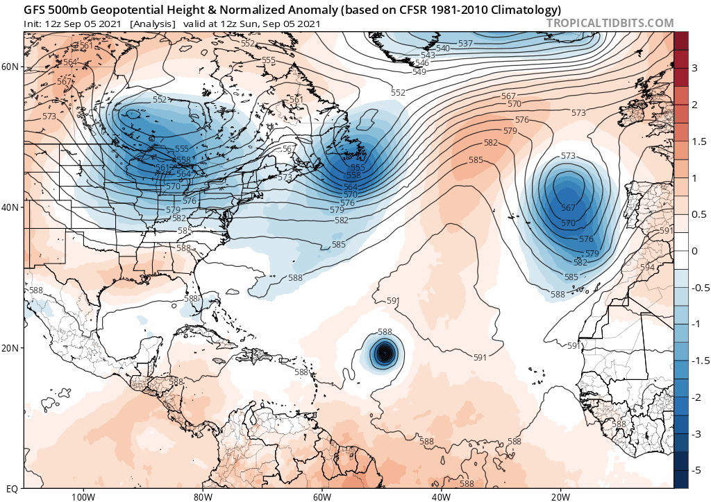
Looks like a quite a progressive pattern across North America and the Atlantic, certainly no widespread expansive ridges over the eastern CONUS or SE Canada on this run of the GFS. Looks more like a fall pattern:
Last edited by gatorcane on Sun Sep 05, 2021 11:45 am, edited 1 time in total.
1 likes
-
cheezyWXguy
- Category 5
- Posts: 6282
- Joined: Mon Feb 13, 2006 12:29 am
- Location: Dallas, TX
Re: 2021 Global Model Runs Discussion (Out thru day 16)
Shell Mound wrote:
Any potential TC in the MDR would likely need to form on or before 13 September to hit the CONUS.
That’s not how climatology works. Climatology is an averaging of individual anomalies to use the past to serve as a general indicator, it does not dictate the future
7 likes
-
Shell Mound
- Category 5
- Posts: 2432
- Age: 33
- Joined: Thu Sep 07, 2017 3:39 pm
- Location: St. Petersburg, FL → Scandinavia
Re: 2021 Global Model Runs Discussion (Out thru day 16)
cheezyWXguy wrote:Shell Mound wrote:
Any potential TC in the MDR would likely need to form on or before 13 September to hit the CONUS.
That’s not how climatology works. Climatology is an averaging of individual anomalies to use the past to serve as a general indicator, it does not dictate the future
"Likely" is based on climatological averages.
1 likes
CVW / MiamiensisWx / Shell Mound
The posts in this forum are NOT official forecasts and should not be used as such. They are just the opinion of the poster and may or may not be backed by sound meteorological data. They are NOT endorsed by any professional institution or STORM2K. For official information, please refer to products from the NHC and NWS.
-
cheezyWXguy
- Category 5
- Posts: 6282
- Joined: Mon Feb 13, 2006 12:29 am
- Location: Dallas, TX
Re: 2021 Global Model Runs Discussion (Out thru day 16)
Shell Mound wrote:cheezyWXguy wrote:Shell Mound wrote:Any potential TC in the MDR would likely need to form on or before 13 September to hit the CONUS.
That’s not how climatology works. Climatology is an averaging of individual anomalies to use the past to serve as a general indicator, it does not dictate the future
"Likely" is based on climatological averages.
I must have misread, I could have sworn your post said “needs to form”, not “would likely need to form”.
1 likes
Who is online
Users browsing this forum: AnnularCane, Ulf and 142 guests