2021 Global Model Runs Discussion (Out thru day 16)
Moderator: S2k Moderators
Forum rules

The posts in this forum are NOT official forecasts and should not be used as such. They are just the opinion of the poster and may or may not be backed by sound meteorological data. They are NOT endorsed by any professional institution or STORM2K. For official information, please refer to products from the National Hurricane Center and National Weather Service.
Re: 2021 Global Model Runs Discussion (Out thru day 16)
Category5Kaiju wrote:Ok, so the most recent GFS run has only Olaf develop in the EPAC with the EPAC and Atlantic quiet with no discernable, sustained cyclone developing afterwards until the 22nd of September. That's just weird to say the least.
I would gladly take no TC's for the rest of the month, but I just don't think it is likely. If you look at the amount storms that have formed in recent years from September 1st to September 22nd you can see that 2021 would end up being on the low end of that list if the GFS verifies.
Named storm counts from recent seasons from September 1st-22nd
2020- 9 (10 If you count Omar which became a TD on August 31st but didn't get named until September 1st)
2019- 6
2018- 6
2017- 4 (3 were majors along with cat 2 Katia)
2016- 4
2015- 4
2014- 2
2013- 4
2012- 2
2011- 5
2010- 6
1 likes
-
Category5Kaiju

- Category 5

- Posts: 4336
- Joined: Thu Dec 24, 2020 12:45 pm
- Location: Seattle during the summer, Phoenix during the winter
Re: 2021 Global Model Runs Discussion (Out thru day 16)
IcyTundra wrote:Category5Kaiju wrote:Ok, so the most recent GFS run has only Olaf develop in the EPAC with the EPAC and Atlantic quiet with no discernable, sustained cyclone developing afterwards until the 22nd of September. That's just weird to say the least.
I would gladly take no TC's for the rest of the month, but I just don't think it is likely. If you look at the amount storms that have formed in recent years from September 1st to September 22nd you can see that 2021 would end up being on the low end of that list if the GFS verifies.
Named storm counts from recent seasons from September 1st-22nd
2020- 9 (10 If you count Omar which became a TD on August 31st but didn't get named until September 1st)
2019- 6
2018- 6
2017- 4 (3 were majors along with cat 2 Katia)
2016- 4
2015- 4
2014- 2
2013- 4
2012- 2
2011- 5
2010- 6
Exactly; hence why I am reluctant to take that run at face value. Especially with the way we already got 12 NSs, 5 Hs, and 3 MHs, I just can't find a logical or empirical reason why all of a sudden a season that has been performing very impressively would just wind down in September of all months. Sure, maybe October, but we're not there yet. And most importantly, La Nina would theoretically favor activity into late season, meaning October cannot be disregarded at this instance in time. I think SFLcane's recent post showing the ensembles and signs of MDR life are more credible than that one GFS run showing nothing the rest of this month.
0 likes
Unless explicitly stated, all information in my posts is based on my own opinions and observations. Tropical storms and hurricanes can be extremely dangerous. Refer to an accredited weather research agency or meteorologist if you need to make serious decisions regarding an approaching storm.
-
AlphaToOmega
- Category 5
- Posts: 1448
- Joined: Sat Jun 26, 2021 10:51 am
- Location: Somewhere in Massachusetts
Re: 2021 Global Model Runs Discussion (Out thru day 16)
IcyTundra wrote:Category5Kaiju wrote:Ok, so the most recent GFS run has only Olaf develop in the EPAC with the EPAC and Atlantic quiet with no discernable, sustained cyclone developing afterwards until the 22nd of September. That's just weird to say the least.
I would gladly take no TC's for the rest of the month, but I just don't think it is likely. If you look at the amount storms that have formed in recent years from September 1st to September 22nd you can see that 2021 would end up being on the low end of that list if the GFS verifies.
Named storm counts from recent seasons from September 1st-22nd
2020- 9 (10 If you count Omar which became a TD on August 31st but didn't get named until September 1st)
2019- 6
2018- 6
2017- 4 (3 were majors along with cat 2 Katia)
2016- 4
2015- 4
2014- 2
2013- 4
2012- 2
2011- 5
2010- 6
That is why you look at ensembles. The operational run seems to be unrealistically bearish for some reason. The ensembles show three more storms forming before September 15.
Last edited by AlphaToOmega on Mon Sep 06, 2021 7:26 pm, edited 1 time in total.
0 likes

Re: 2021 Global Model Runs Discussion (Out thru day 16)
SFLcane wrote:Look at the Mdr support.
https://i.postimg.cc/1t4WqcBm/403-B8-C12-4-A70-43-BD-9433-22-B0-AD4178-AA.gif
What's concerning is that SSTs in the eastern MDR have cooled due to Larry, while the western MDR and Caribbean are warming. So theoretically these future CV storms might stay weak initially and thus travel further west, posing a greater land threat.
6 likes
TC naming lists: retirements and intensity
Most aggressive Advisory #1's in North Atlantic (cr. kevin for starting the list)
Most aggressive Advisory #1's in North Atlantic (cr. kevin for starting the list)
-
Blown Away

- S2K Supporter

- Posts: 10253
- Joined: Wed May 26, 2004 6:17 am
Re: 2021 Global Model Runs Discussion (Out thru day 16)
Teban54 wrote:SFLcane wrote:Look at the Mdr support.
https://i.postimg.cc/1t4WqcBm/403-B8-C12-4-A70-43-BD-9433-22-B0-AD4178-AA.gif
What's concerning is that SSTs in the eastern MDR have cooled due to Larry, while the western MDR and Caribbean are warming. So theoretically these future CV storms might stay weak initially and thus travel further west, posing a greater land threat.
GFS 10+ day range showing many TW’s moving WNW across the Atlantic through/near NE Caribbean and into CONUS...
1 likes
Hurricane Eye Experience: David 79, Irene 99, Frances 04, Jeanne 04, Wilma 05… Hurricane Brush Experience: Andrew 92, Erin 95, Floyd 99, Matthew 16, Irma 17, Ian 22, Nicole 22…

Re: 2021 Global Model Runs Discussion (Out thru day 16)
Looks like support is growing for something in the BOC or western Gulf.
0 likes
Re: 2021 Global Model Runs Discussion (Out thru day 16)
00Z ICON with a weak low in the BOC towards the end of next weekend.

0 likes
Re: 2021 Global Model Runs Discussion (Out thru day 16)
IcyTundra wrote:00Z ICON with a weak low in the BOC towards the end of next weekend.
https://i.imgur.com/tWotuGS.gif
That looks very similar to what a lot of ensembles are saying.
0 likes
-
Hurricaneman

- Category 5
- Posts: 7404
- Age: 45
- Joined: Tue Aug 31, 2004 3:24 pm
- Location: central florida
Re: 2021 Global Model Runs Discussion (Out thru day 16)
The Euro is adjusting south with its location of the September 10/11 wave coming off of Africa, maybe something to the trend
0 likes
-
Yellow Evan

- Professional-Met

- Posts: 16241
- Age: 27
- Joined: Fri Jul 15, 2011 12:48 pm
- Location: Henderson, Nevada/Honolulu, HI
- Contact:
Re: 2021 Global Model Runs Discussion (Out thru day 16)
Hurricaneman wrote:The Euro is adjusting south with its location of the September 10/11 wave coming off of Africa, maybe something to the trend
This is a longtime ECMWF bias correcting itself. Keep on eye on this as it continues to trend westward - it’s not out of the question this ends up showing a long tracked major hurricane with a steering setup that wouldn’t favor a recurvature.
2 likes
-
cycloneye

- Admin

- Posts: 149518
- Age: 69
- Joined: Thu Oct 10, 2002 10:54 am
- Location: San Juan, Puerto Rico
Re: 2021 Global Model Runs Discussion (Out thru day 16)

3 likes
Visit the Caribbean-Central America Weather Thread where you can find at first post web cams,radars
and observations from Caribbean basin members Click Here
and observations from Caribbean basin members Click Here
-
CyclonicFury

- Category 5
- Posts: 2035
- Age: 27
- Joined: Sun Jul 02, 2017 12:32 pm
- Location: NC
- Contact:
Re: 2021 Global Model Runs Discussion (Out thru day 16)
The 12z UKMET seems to be suffering from the same issue as the ECMWF (developing an inland-storm and having a TC already developed when exiting Africa). This doesn't make sense so it is possible we eventually get an initially weaker TC, with a farther south and west track.
NEW TROPICAL CYCLONE FORECAST TO DEVELOP AFTER 96 HOURS
FORECAST POSITION AT T+ 96 : 15.9N 17.6W
LEAD CENTRAL MAXIMUM WIND
VERIFYING TIME TIME POSITION PRESSURE (MB) SPEED (KNOTS)
-------------- ---- -------- ------------- -------------
1200UTC 11.09.2021 96 15.9N 17.6W 990 51
0000UTC 12.09.2021 108 17.0N 20.6W 986 54
1200UTC 12.09.2021 120 18.3N 22.7W 987 52
0000UTC 13.09.2021 132 19.5N 23.7W 992 46
1200UTC 13.09.2021 144 21.4N 23.7W 988 51
0 likes
NCSU B.S. in Meteorology Class of 2021. Tropical weather blogger at http://www.cyclonicfury.com. My forecasts and thoughts are NOT official, for official forecasts please consult the National Hurricane Center.
-
Spacecoast

- Category 2

- Posts: 773
- Joined: Thu Aug 31, 2017 2:03 pm
Re: 2021 Global Model Runs Discussion (Out thru day 16)
0z ECMF Ens:

Last edited by Spacecoast on Tue Sep 07, 2021 12:34 pm, edited 2 times in total.
0 likes
-
Category5Kaiju
- Category 5
- Posts: 4336
- Joined: Thu Dec 24, 2020 12:45 pm
- Location: Seattle during the summer, Phoenix during the winter
Re: 2021 Global Model Runs Discussion (Out thru day 16)
GFS trended stronger with 91L and shows a BoC storm right after that. Again, I personally think there's some decent support for a September that is not inactive as some are suggesting.
0 likes
Unless explicitly stated, all information in my posts is based on my own opinions and observations. Tropical storms and hurricanes can be extremely dangerous. Refer to an accredited weather research agency or meteorologist if you need to make serious decisions regarding an approaching storm.
Re: 2021 Global Model Runs Discussion (Out thru day 16)
The 00Z Euro from last night is suggesting there could be stronger ridging over the Atlantic around the 10 day range anything that comes off of Africa would have a higher chance of getting further west before recurving.
Edit: The GFS seems to have the same idea.
Edit: The GFS seems to have the same idea.
1 likes
-
Stormybajan

- Category 1

- Posts: 453
- Joined: Thu May 20, 2021 3:21 pm
- Location: Windward Islands
Re: 2021 Global Model Runs Discussion (Out thru day 16)
Besides two quick spins up in the gulf (91L and another system around the 13th). No strong development from the GFS in the 12z run. Meanwhile the CMC shows multiple areas of vorticity throughout the Atlantic but nothing concrete..I think about 5 days that will change
0 likes
Sad West Indies and Manchester United fan ⚽️
-
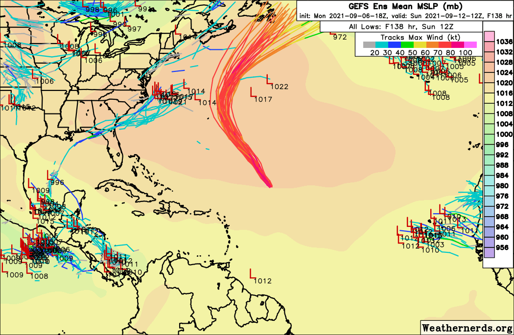
Spacecoast
- Category 2
- Posts: 773
- Joined: Thu Aug 31, 2017 2:03 pm
Re: 2021 Global Model Runs Discussion (Out thru day 16)
12z GEFS:

Last edited by Spacecoast on Tue Sep 07, 2021 2:22 pm, edited 1 time in total.
0 likes
Re: 2021 Global Model Runs Discussion (Out thru day 16)
12Z Euro with a strong signal for more waves to develop coming off of Africa. It remains to be seen what the steering pattern will be, but we will certainly have a lot to watch in the 2nd half of September.

0 likes
-
SFLcane

- S2K Supporter
- Posts: 10281
- Age: 48
- Joined: Sat Jun 05, 2010 1:44 pm
- Location: Lake Worth Florida
Re: 2021 Global Model Runs Discussion (Out thru day 16)
Maybe Africa is the new gulf coast. Tc’s going backwards now 
3 likes
Who is online
Users browsing this forum: No registered users and 107 guests