2021 Indicators: SST's / SAL / MSLP / Shear / Steering / Instability / Sat Images
Moderator: S2k Moderators
Forum rules

The posts in this forum are NOT official forecasts and should not be used as such. They are just the opinion of the poster and may or may not be backed by sound meteorological data. They are NOT endorsed by any professional institution or STORM2K. For official information, please refer to products from the National Hurricane Center and National Weather Service.

Re: 2021 Indicators: SST's / SAL / MSLP / Shear / Steering / Instability / Sat Images
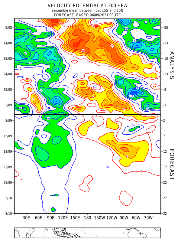
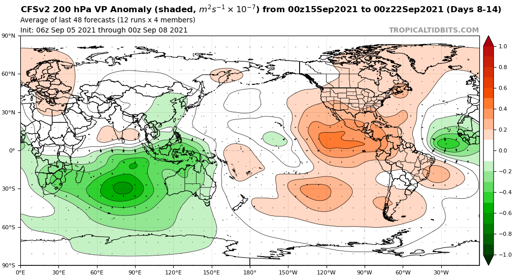
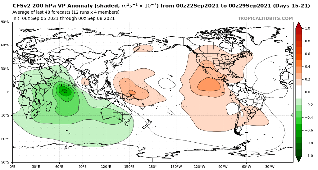
The weekly Euro VP chart shows rising motion in the eastern Atlantic when the Sept16-18 wave emerges and develops. Perhaps we could see rapid genesis off the African coast, then several days of it staying weak and south (not strong enough to be pulled north by any big breaks in the ridge) due to +VP anomalies, before finding better conditions somewhere in the western half of the basin. Plenty of September Cape Verde hurricanes started off this way, including Edouard and Igor, although those are extreme examples when it comes to intensity. Other weaker MDR hurricanes have had several day struggle periods.
6 likes
Irene '11 Sandy '12 Hermine '16 5/15/2018 Derecho Fay '20 Isaias '20 Elsa '21 Henri '21 Ida '21
I am only a meteorology enthusiast who knows a decent amount about tropical cyclones. Look to the professional mets, the NHC, or your local weather office for the best information.
I am only a meteorology enthusiast who knows a decent amount about tropical cyclones. Look to the professional mets, the NHC, or your local weather office for the best information.
-
Yellow Evan

- Professional-Met

- Posts: 16241
- Age: 27
- Joined: Fri Jul 15, 2011 12:48 pm
- Location: Henderson, Nevada/Honolulu, HI
- Contact:
Re: 2021 Indicators: SST's / SAL / MSLP / Shear / Steering / Instability / Sat Images
AlphaToOmega wrote:Yellow Evan wrote:AlphaToOmega wrote:
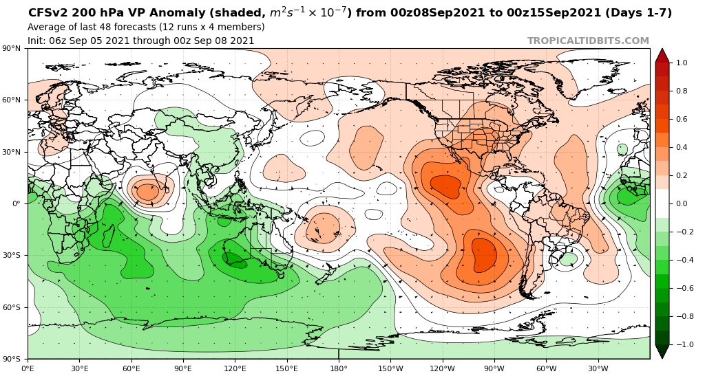
What models is NOAA using? Both the CFSv2 and ECMWF indicate a favorable VP pattern for September.
We’re late enough into September that it’s more useful looking at sub-monthly VP composites (like the GEFS/EPS 16/45 day VP forecasts).
Weekly CFSv2 and extended ECMWF forecasts show -VP for West Africa and the Indian Ocean, which is favorable for development.
https://i.postimg.cc/SsKgDgW4/pdf2svg-worker-commands-f7f8587d8-fswz5-6fe5cac1a363ec1525f54343b6cc9fd8-Cw12-He.png
https://i.postimg.cc/GtGgyHFT/cfs-avg-chi200-Mean-global-1.png
https://i.postimg.cc/RCHD8bkC/cfs-avg-chi200-Mean-global-2.png
https://i.postimg.cc/3JQcHFhX/cfs-avg-chi200-Mean-global-3.png
Either the CFSv2 and ECMWF are lying to us, or September will be favorable for tropical cyclone development.
The CFS tends to be pretty erratic and slow moving with the -VP. The ECMWF keeps the rising motion in the Bay of Bangel which would favor activity in the Arabian Sea if anything.
2 likes
-
AlphaToOmega
- Category 5

- Posts: 1448
- Joined: Sat Jun 26, 2021 10:51 am
- Location: Somewhere in Massachusetts
Re: 2021 Indicators: SST's / SAL / MSLP / Shear / Steering / Instability / Sat Images
Yellow Evan wrote:AlphaToOmega wrote:Yellow Evan wrote:
We’re late enough into September that it’s more useful looking at sub-monthly VP composites (like the GEFS/EPS 16/45 day VP forecasts).
Weekly CFSv2 and extended ECMWF forecasts show -VP for West Africa and the Indian Ocean, which is favorable for development.
https://i.postimg.cc/SsKgDgW4/pdf2svg-worker-commands-f7f8587d8-fswz5-6fe5cac1a363ec1525f54343b6cc9fd8-Cw12-He.png
https://i.postimg.cc/GtGgyHFT/cfs-avg-chi200-Mean-global-1.png
https://i.postimg.cc/RCHD8bkC/cfs-avg-chi200-Mean-global-2.png
https://i.postimg.cc/3JQcHFhX/cfs-avg-chi200-Mean-global-3.png
Either the CFSv2 and ECMWF are lying to us, or September will be favorable for tropical cyclone development.
The CFS tends to be pretty erratic and slow moving with the -VP. The ECMWF keeps the rising motion in the Bay of Bangel which would favor activity in the Arabian Sea if anything.
Based on the historical record, rising motion in the Bay of Bangel correlates with hyperactive hurricane seasons.
The CFSv2 also always wants to kill the WAM, so to see it show -VP over West Africa is very significant.
Last edited by AlphaToOmega on Wed Sep 08, 2021 5:47 pm, edited 1 time in total.
1 likes
-
AlphaToOmega
- Category 5
- Posts: 1448
- Joined: Sat Jun 26, 2021 10:51 am
- Location: Somewhere in Massachusetts
Re: 2021 Indicators: SST's / SAL / MSLP / Shear / Steering / Instability / Sat Images
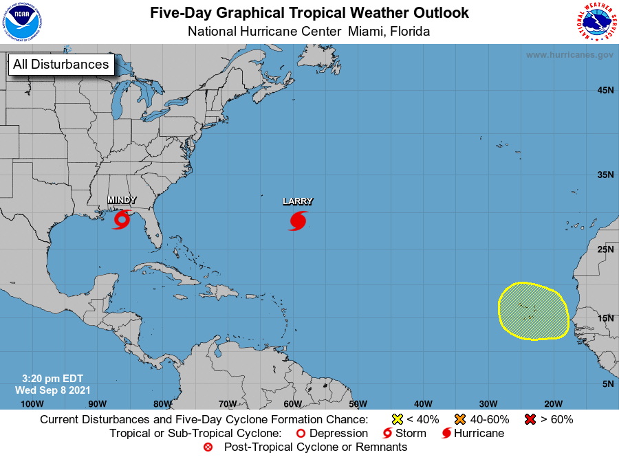
Snapshot of the Atlantic
1 likes
-
Category5Kaiju

- Category 5
- Posts: 4336
- Joined: Thu Dec 24, 2020 12:45 pm
- Location: Seattle during the summer, Phoenix during the winter
Re: 2021 Indicators: SST's / SAL / MSLP / Shear / Steering / Instability / Sat Images
Fun but not so fun fact: once Mindy makes landfall, more than half of the 13 NSs that have occurred so far would have directly hit the CONUS.
5 likes
Unless explicitly stated, all information in my posts is based on my own opinions and observations. Tropical storms and hurricanes can be extremely dangerous. Refer to an accredited weather research agency or meteorologist if you need to make serious decisions regarding an approaching storm.
-
AlphaToOmega
- Category 5
- Posts: 1448
- Joined: Sat Jun 26, 2021 10:51 am
- Location: Somewhere in Massachusetts
Re: 2021 Indicators: SST's / SAL / MSLP / Shear / Steering / Instability / Sat Images
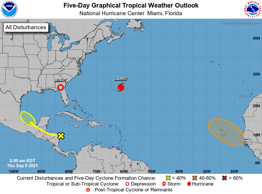
Two storms (Larry and Mindy) have already formed in September 2021. With two potential candidates for Nicholas (one in the MDR and one in the BoC), September is shaping up to be active.
0 likes
-
Category5Kaiju
- Category 5
- Posts: 4336
- Joined: Thu Dec 24, 2020 12:45 pm
- Location: Seattle during the summer, Phoenix during the winter
Re: 2021 Indicators: SST's / SAL / MSLP / Shear / Steering / Instability / Sat Images
AlphaToOmega wrote:Two storms (Larry and Mindy) have already formed in September 2021. With two potential candidates for Nicholas (one in the MDR and one in the BoC), September is shaping up to be active.
And it does not stop there; assuming the BoC and the lemon form, there are ensemble hints of another MDR system near the September 18ish timeframe. I would argue that if everything goes in favor of TCG in the Atlantic, then reaching Peter by the 20th of this month may not be very ludicrous.
0 likes
Unless explicitly stated, all information in my posts is based on my own opinions and observations. Tropical storms and hurricanes can be extremely dangerous. Refer to an accredited weather research agency or meteorologist if you need to make serious decisions regarding an approaching storm.
-
AnnularCane

- S2K Supporter

- Posts: 2962
- Joined: Thu Jun 08, 2006 9:18 am
- Location: Wytheville, VA
Re: 2021 Indicators: SST's / SAL / MSLP / Shear / Steering / Instability / Sat Images
Category5Kaiju wrote:AlphaToOmega wrote:Two storms (Larry and Mindy) have already formed in September 2021. With two potential candidates for Nicholas (one in the MDR and one in the BoC), September is shaping up to be active.
And it does not stop there; assuming the BoC and the lemon form, there are ensemble hints of another MDR system near the September 18ish timeframe. I would argue that if everything goes in favor of TCG in the Atlantic, then reaching Peter by the 20th of this month may not be very ludicrous.
Is that BOC storm still in the cards? I don't think I've heard much about it lately.
0 likes
"But it never rained rain. It never snowed snow. And it never blew just wind. It rained things like soup and juice. It snowed mashed potatoes and green peas. And sometimes the wind blew in storms of hamburgers." -- Judi Barrett, Cloudy with a Chance of Meatballs
Re: 2021 Indicators: SST's / SAL / MSLP / Shear / Steering / Instability / Sat Images
AnnularCane wrote:Category5Kaiju wrote:AlphaToOmega wrote:Two storms (Larry and Mindy) have already formed in September 2021. With two potential candidates for Nicholas (one in the MDR and one in the BoC), September is shaping up to be active.
And it does not stop there; assuming the BoC and the lemon form, there are ensemble hints of another MDR system near the September 18ish timeframe. I would argue that if everything goes in favor of TCG in the Atlantic, then reaching Peter by the 20th of this month may not be very ludicrous.
Is that BOC storm still in the cards? I don't think I've heard much about it lately.
Pretty much every model keeps it too close to the coast now, so I would say no.
1 likes
Irene '11 Sandy '12 Hermine '16 5/15/2018 Derecho Fay '20 Isaias '20 Elsa '21 Henri '21 Ida '21
I am only a meteorology enthusiast who knows a decent amount about tropical cyclones. Look to the professional mets, the NHC, or your local weather office for the best information.
I am only a meteorology enthusiast who knows a decent amount about tropical cyclones. Look to the professional mets, the NHC, or your local weather office for the best information.
-
Yellow Evan
- Professional-Met
- Posts: 16241
- Age: 27
- Joined: Fri Jul 15, 2011 12:48 pm
- Location: Henderson, Nevada/Honolulu, HI
- Contact:
Re: 2021 Indicators: SST's / SAL / MSLP / Shear / Steering / Instability / Sat Images
AlphaToOmega wrote:Yellow Evan wrote:AlphaToOmega wrote:
Weekly CFSv2 and extended ECMWF forecasts show -VP for West Africa and the Indian Ocean, which is favorable for development.
https://i.postimg.cc/SsKgDgW4/pdf2svg-worker-commands-f7f8587d8-fswz5-6fe5cac1a363ec1525f54343b6cc9fd8-Cw12-He.png
https://i.postimg.cc/GtGgyHFT/cfs-avg-chi200-Mean-global-1.png
https://i.postimg.cc/RCHD8bkC/cfs-avg-chi200-Mean-global-2.png
https://i.postimg.cc/3JQcHFhX/cfs-avg-chi200-Mean-global-3.png
Either the CFSv2 and ECMWF are lying to us, or September will be favorable for tropical cyclone development.
The CFS tends to be pretty erratic and slow moving with the -VP. The ECMWF keeps the rising motion in the Bay of Bangel which would favor activity in the Arabian Sea if anything.
Based on the historical record, rising motion in the Bay of Bangel correlates with hyperactive hurricane seasons.
The CFSv2 also always wants to kill the WAM, so to see it show -VP over West Africa is very significant.
Correct though most hyperactive seasons don’t have as much sinking motion over the Western Atlantic itself.
1 likes

Re: 2021 Indicators: SST's / SAL / MSLP / Shear / Steering / Instability / Sat Images
Since current expectations seem to be a burst of activity in late September that may last into October, out of curiosity and boredom, here are all storms that formed between Sep 20 and Sep 30 in the current active era. This is likely quite pointless, but feel free to draw any conclusions from here.
- 2020: None
- 2019: TS Karen formed on Sep 22; C5 Lorenzo formed on Sep 23
- 2018: TD11 formed on Sep 21; TS Kirk formed on Sep 22; C1 Leslie formed on Sep 23
- 2017: None (C3 Lee regenerated on Sep 22)
- 2016: C5 Matthew formed on Sep 28
- 2015: C4 Joaquin formed on Sep 28
- 2014: None
- 2013: TS Jerry formed on Sep 29
- 2012: None (C1 Nadine regenerated on Sep 23)
- 2011: C4 Ophelia formed on Sep 20; C1 Philippe formed on Sep 24
- 2010: C1 Lisa formed on Sep 20; TS Matthew formed on Sep 23; TS Nicole formed on Sep 28
- 2009: TD8 formed on Sep 25
- 2008: C1 Kyle formed on Sep 25; TS Laura formed on Sep 29
- 2007: TD10 formed on Sep 21; TS Jerry formed on Sep 23; C1 Karen formed on Sep 25; C1 Lorenzo formed on Sep 25; TS Melissa formed on Sep 28
- 2006: C1 Isaac formed on Sep 27
- 2005: TD19 formed on Sep 30
- 2004: None
- 2003: C2 Juan formed on Sep 24; C3 Kate formed on Sep 25
- 2002: C1 Kyle formed on Sep 20; C4 Lili formed on Sep 21
- 2001: C2 Humberto formed on Sep 21
- 2000: C4 Isaac formed on Sep 21; C1 Joyce formed on Sep 25; C4 Keith formed on Sep 28
- 1999: None
- 1998: C2 Jeanne formed on Sep 21; C2 Karl formed on Sep 23
- 1997: None
- 1996: C3 Isidore formed on Sep 24
- 1995: C1 Noel formed on Sep 26; C4 Opal formed on Sep 27
In terms of the general pattern of activity per season, I find 1998 to be a decent analog to 2021 so far, with a burst of activity from mid-August to early September (4-3-1), another burst in the second half of September (5-4-1 including Georges), and then Mitch in late October. ACE wise, 1998 was at ~57 on Sep 15 before Georges formed; 2021 is now at 70.6. 1998 finished with 182 ACE, largely thanks to Georges and Mitch.
1995 might also be a good analog, given an intense period of activity in August (7-4-2 with more NS than Aug 2021, plus C2 Erin that formed on July 31), followed by a relatively quiet mid-September with only C3 Marilyn forming on Sep 12. Luis 1995 shares some similarities with Larry 2021 too. 1995 later produced two more majors, Opal and Roxanne, in early October.
(Edit: 2007 may be another analog, with two Cat 5s by early September and then 4 TS/C1s during Sep 20-30. Everything struggled in that season except Dean and Felix, though.)
As for possible land threats from storms forming during the Sep 20-30 period since 1995:
- Storms that formed in the MDR: 14-12-6, with landfalls 1-1-0 (only Lili 2002)
- Storms that formed in the western tropics (Caribbean, Gulf etc)(*): 8-5-3, with landfalls 7-5-2 (two major landfalls are Opal and Matthew(**))
(*) Counted Kyle 2008 which formed just north of DR, but not anything further north than that (sorry Joaquin).
(**) Matthew formed near Barbados, so it can count as a MDR storm in some way if you want to. Same for Karen 2019, which I also put under the western tropics category.
4 likes
TC naming lists: retirements and intensity
Most aggressive Advisory #1's in North Atlantic (cr. kevin for starting the list)
Most aggressive Advisory #1's in North Atlantic (cr. kevin for starting the list)
-
AlphaToOmega
- Category 5
- Posts: 1448
- Joined: Sat Jun 26, 2021 10:51 am
- Location: Somewhere in Massachusetts
Re: 2021 Indicators: SST's / SAL / MSLP / Shear / Steering / Instability / Sat Images
September will do what September does
0 likes
-
Category5Kaiju
- Category 5
- Posts: 4336
- Joined: Thu Dec 24, 2020 12:45 pm
- Location: Seattle during the summer, Phoenix during the winter
Re: 2021 Indicators: SST's / SAL / MSLP / Shear / Steering / Instability / Sat Images
AlphaToOmega wrote:September will do what September does
https://i.postimg.cc/D0tfGQZd/two-atl-5d0.png
Assuming both AOIs form, we would get to Peter, and by then we would still have a chunk of September left. Unfortunately, I seriously am thinking that we are going to soon look back to all of this talk of SAL, unfavorable MJO, and September 10 not featuring simultaneous storms, and say to ourselves “oh how little we knew.”
1 likes
Unless explicitly stated, all information in my posts is based on my own opinions and observations. Tropical storms and hurricanes can be extremely dangerous. Refer to an accredited weather research agency or meteorologist if you need to make serious decisions regarding an approaching storm.


Re: 2021 Indicators: SST's / SAL / MSLP / Shear / Steering / Instability / Sat Images
aspen wrote:The weekly Euro VP chart shows rising motion in the eastern Atlantic when the Sept16-18 wave emerges and develops. Perhaps we could see rapid genesis off the African coast, then several days of it staying weak and south (not strong enough to be pulled north by any big breaks in the ridge) due to +VP anomalies, before finding better conditions somewhere in the western half of the basin. Plenty of September Cape Verde hurricanes started off this way, including Edouard and Igor, although those are extreme examples when it comes to intensity. Other weaker MDR hurricanes have had several day struggle periods.
>edouard
>extreme examples when it comes to intensity
>formed in september
Wasn't this a marginal category 3 in 2014?
0 likes
blonde stacey (xe/xem/xir)
-
SconnieCane
- Category 5
- Posts: 1013
- Joined: Thu Aug 02, 2018 5:29 pm
- Location: Madison, WI
Re: 2021 Indicators: SST's / SAL / MSLP / Shear / Steering / Instability / Sat Images
DioBrando wrote:aspen wrote:The weekly Euro VP chart shows rising motion in the eastern Atlantic when the Sept16-18 wave emerges and develops. Perhaps we could see rapid genesis off the African coast, then several days of it staying weak and south (not strong enough to be pulled north by any big breaks in the ridge) due to +VP anomalies, before finding better conditions somewhere in the western half of the basin. Plenty of September Cape Verde hurricanes started off this way, including Edouard and Igor, although those are extreme examples when it comes to intensity. Other weaker MDR hurricanes have had several day struggle periods.
>edouard
>extreme examples when it comes to intensity
>formed in september
Wasn't this a marginal category 3 in 2014?
At first I thought he was referring to 1996 Edouard (which peaked as a 125kt Cat. 4 and was at one point thought to be a landfall threat for New England, hence it's the first storm I think of when I hear that name in reference to a hurricane), but that was an August-early September storm.
0 likes
Re: 2021 Indicators: SST's / SAL / MSLP / Shear / Steering / Instability / Sat Images
DioBrando wrote:aspen wrote:The weekly Euro VP chart shows rising motion in the eastern Atlantic when the Sept16-18 wave emerges and develops. Perhaps we could see rapid genesis off the African coast, then several days of it staying weak and south (not strong enough to be pulled north by any big breaks in the ridge) due to +VP anomalies, before finding better conditions somewhere in the western half of the basin. Plenty of September Cape Verde hurricanes started off this way, including Edouard and Igor, although those are extreme examples when it comes to intensity. Other weaker MDR hurricanes have had several day struggle periods.
>edouard
>extreme examples when it comes to intensity
>formed in september
Wasn't this a marginal category 3 in 2014?
I’m talking about Edouard ‘96, which was an excellent long-tracking major (although it did get too close for comfort to New England). Yes, it was an earlier peak season storm, but it was an example of a Cape Verde system that struggled for days but became quite potent later on.
0 likes
Irene '11 Sandy '12 Hermine '16 5/15/2018 Derecho Fay '20 Isaias '20 Elsa '21 Henri '21 Ida '21
I am only a meteorology enthusiast who knows a decent amount about tropical cyclones. Look to the professional mets, the NHC, or your local weather office for the best information.
I am only a meteorology enthusiast who knows a decent amount about tropical cyclones. Look to the professional mets, the NHC, or your local weather office for the best information.
-
Category5Kaiju
- Category 5
- Posts: 4336
- Joined: Thu Dec 24, 2020 12:45 pm
- Location: Seattle during the summer, Phoenix during the winter
Re: 2021 Indicators: SST's / SAL / MSLP / Shear / Steering / Instability / Sat Images
aspen wrote:DioBrando wrote:aspen wrote:The weekly Euro VP chart shows rising motion in the eastern Atlantic when the Sept16-18 wave emerges and develops. Perhaps we could see rapid genesis off the African coast, then several days of it staying weak and south (not strong enough to be pulled north by any big breaks in the ridge) due to +VP anomalies, before finding better conditions somewhere in the western half of the basin. Plenty of September Cape Verde hurricanes started off this way, including Edouard and Igor, although those are extreme examples when it comes to intensity. Other weaker MDR hurricanes have had several day struggle periods.
>edouard
>extreme examples when it comes to intensity
>formed in september
Wasn't this a marginal category 3 in 2014?
I’m talking about Edouard ‘96, which was an excellent long-tracking major (although it did get too close for comfort to New England). Yes, it was an earlier peak season storm, but it was an example of a Cape Verde system that struggled for days but became quite potent later on.
Earl 2010 is also a great example of such too
0 likes
Unless explicitly stated, all information in my posts is based on my own opinions and observations. Tropical storms and hurricanes can be extremely dangerous. Refer to an accredited weather research agency or meteorologist if you need to make serious decisions regarding an approaching storm.
Re: 2021 Indicators: SST's / SAL / MSLP / Shear / Steering / Instability / Sat Images
aspen wrote:DioBrando wrote:aspen wrote:The weekly Euro VP chart shows rising motion in the eastern Atlantic when the Sept16-18 wave emerges and develops. Perhaps we could see rapid genesis off the African coast, then several days of it staying weak and south (not strong enough to be pulled north by any big breaks in the ridge) due to +VP anomalies, before finding better conditions somewhere in the western half of the basin. Plenty of September Cape Verde hurricanes started off this way, including Edouard and Igor, although those are extreme examples when it comes to intensity. Other weaker MDR hurricanes have had several day struggle periods.
>edouard
>extreme examples when it comes to intensity
>formed in september
Wasn't this a marginal category 3 in 2014?
I’m talking about Edouard ‘96, which was an excellent long-tracking major (although it did get too close for comfort to New England). Yes, it was an earlier peak season storm, but it was an example of a Cape Verde system that struggled for days but became quite potent later on.
Interestingly, Edouard '96 and Igor '10 became majors at roughly the same longitude as Larry '21, and Igor was even further north than Larry at that point. Larry did spend more time as a Cat 1 than these two, but the difference is not that significant IMO (1.5 days vs 0.5-1 days). Still, Edouard and Igor took on tracks much further SW than Larry, hence why they could get stronger.
Seems to me that it might have more to do with the steering pattern than strength alone. Larry would likely have been a solid Cat 4 or even Cat 5 if it tracked further SW and passed just east of the islands like Edouard.
0 likes
TC naming lists: retirements and intensity
Most aggressive Advisory #1's in North Atlantic (cr. kevin for starting the list)
Most aggressive Advisory #1's in North Atlantic (cr. kevin for starting the list)
-
cycloneye

- Admin

- Posts: 149515
- Age: 69
- Joined: Thu Oct 10, 2002 10:54 am
- Location: San Juan, Puerto Rico
Re: 2021 Indicators: SST's / SAL / MSLP / Shear / Steering / Instability / Sat Images
0 likes
Visit the Caribbean-Central America Weather Thread where you can find at first post web cams,radars
and observations from Caribbean basin members Click Here
and observations from Caribbean basin members Click Here
-
toad strangler

- S2K Supporter
- Posts: 4546
- Joined: Sun Jul 28, 2013 3:09 pm
- Location: Earth
- Contact:
Who is online
Users browsing this forum: WaveBreaking and 162 guests