https://twitter.com/AnthonyMweather/status/1436147718796324864
EPAC: OLAF - Post-Tropical
Moderator: S2k Moderators
-
cycloneye

- Admin

- Posts: 149550
- Age: 69
- Joined: Thu Oct 10, 2002 10:54 am
- Location: San Juan, Puerto Rico
Re: EPAC: OLAF - Hurricane
1 likes
Visit the Caribbean-Central America Weather Thread where you can find at first post web cams,radars
and observations from Caribbean basin members Click Here
and observations from Caribbean basin members Click Here
-
Yellow Evan

- Professional-Met

- Posts: 16242
- Age: 27
- Joined: Fri Jul 15, 2011 12:48 pm
- Location: Henderson, Nevada/Honolulu, HI
- Contact:
-
Sciencerocks
- Category 5

- Posts: 10186
- Age: 40
- Joined: Thu Jul 06, 2017 1:51 am
-
Kingarabian

- S2K Supporter

- Posts: 16373
- Joined: Sat Aug 08, 2009 3:06 am
- Location: Honolulu, Hawaii
Re: EPAC: OLAF - Hurricane
UW - CIMSS
ADVANCED DVORAK TECHNIQUE
ADT-Version 9.0
Tropical Cyclone Intensity Algorithm
----- Current Analysis -----
Date : 10 SEP 2021 Time : 012031 UTC
Lat : 22:57:35 N Lon : 109:16:11 W
CI# /Pressure/ Vmax
5.1 / 961.4mb/ 92.4kt
Final T# Adj T# Raw T#
5.1 5.5 5.5
Estimated radius of max. wind based on IR : 13 km
Center Temp : -11.6C Cloud Region Temp : -63.2C
Scene Type : EYE
Subtropical Adjustment : OFF
Extratropical Adjustment : OFF
Positioning Method : ARCHER POSITIONING
Ocean Basin : EAST PACIFIC
Dvorak CI > MSLP Conversion Used : CKZ Method
Tno/CI Rules : Constraint Limits : NO LIMIT
Weakening Flag : OFF
Rapid Dissipation Flag : OFF
C/K/Z MSLP Estimate Inputs :
- Average 34 knot radii : 72nmi
- Environmental MSLP : 1008mb
Satellite Name : GOES17
Satellite Viewing Angle : 41.2 degrees
UW - CIMSS
ADVANCED DVORAK TECHNIQUE
ADT-Version 9.0
Tropical Cyclone Intensity Algorithm
----- Current Analysis -----
Date : 10 SEP 2021 Time : 012031 UTC
Lat : 22:57:35 N Lon : 109:16:11 W
CI# /Pressure/ Vmax
5.1 / 961.4mb/ 92.4kt
Final T# Adj T# Raw T#
5.1 5.5 5.5
Estimated radius of max. wind based on IR : 13 km
Center Temp : -11.6C Cloud Region Temp : -63.2C
Scene Type : EYE
Subtropical Adjustment : OFF
Extratropical Adjustment : OFF
Positioning Method : ARCHER POSITIONING
Ocean Basin : EAST PACIFIC
Dvorak CI > MSLP Conversion Used : CKZ Method
Tno/CI Rules : Constraint Limits : NO LIMIT
Weakening Flag : OFF
Rapid Dissipation Flag : OFF
C/K/Z MSLP Estimate Inputs :
- Average 34 knot radii : 72nmi
- Environmental MSLP : 1008mb
Satellite Name : GOES17
Satellite Viewing Angle : 41.2 degrees
0 likes
RIP Kobe Bryant
-
Kingarabian
- S2K Supporter
- Posts: 16373
- Joined: Sat Aug 08, 2009 3:06 am
- Location: Honolulu, Hawaii
-
grapealcoholic
- Category 2

- Posts: 703
- Joined: Tue Aug 10, 2021 3:26 pm
-
grapealcoholic
- Category 2
- Posts: 703
- Joined: Tue Aug 10, 2021 3:26 pm
-
Kingarabian
- S2K Supporter
- Posts: 16373
- Joined: Sat Aug 08, 2009 3:06 am
- Location: Honolulu, Hawaii

-
Kingarabian
- S2K Supporter
- Posts: 16373
- Joined: Sat Aug 08, 2009 3:06 am
- Location: Honolulu, Hawaii
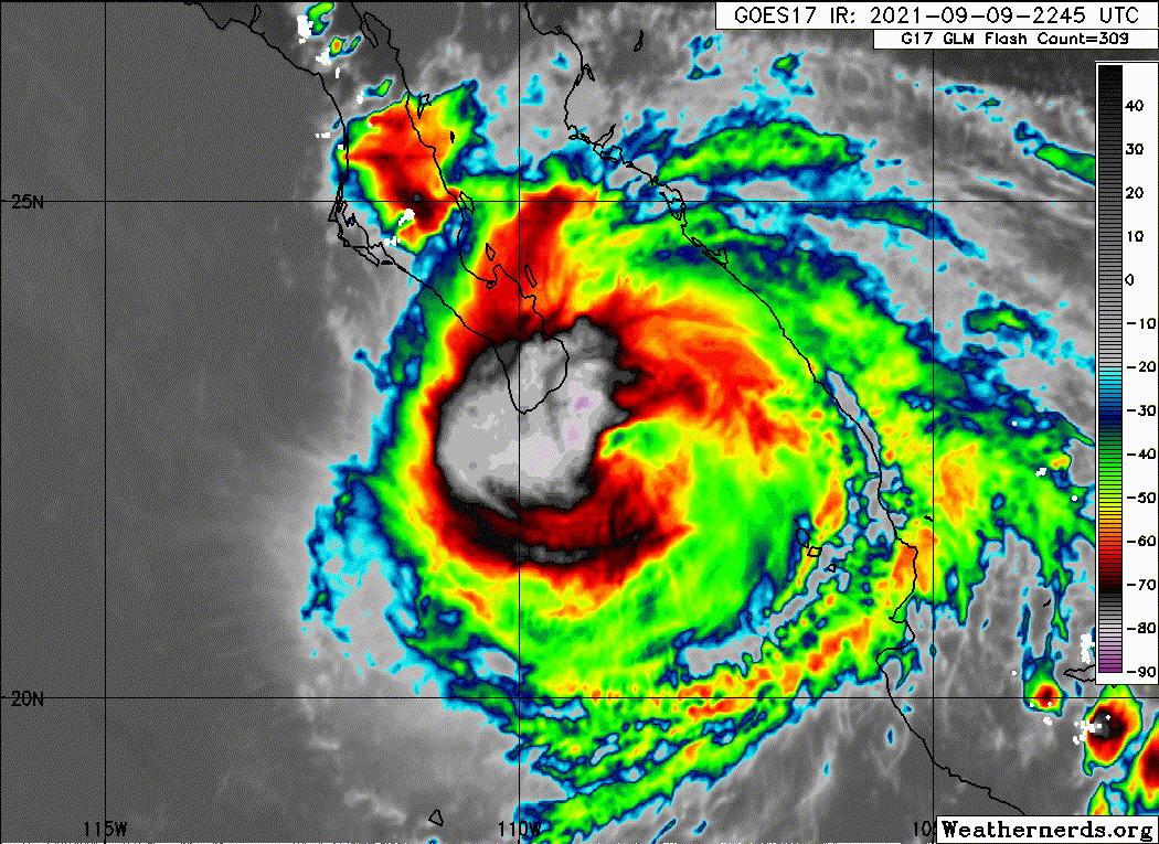
Re: EPAC: OLAF - Hurricane
https://twitter.com/iCyclone/status/1436143578141507604
I hope Josh gives us some actual numbers ahead of time instead of a bunch of "wow crazy getting nuts here" lol.
https://twitter.com/iCyclone/status/1436152936384512000
 Eyeball test that this is atleast a Cat.2 here.
I hope Josh gives us some actual numbers ahead of time instead of a bunch of "wow crazy getting nuts here" lol.
https://twitter.com/iCyclone/status/1436152936384512000
Last edited by Kingarabian on Thu Sep 09, 2021 9:24 pm, edited 1 time in total.
5 likes
RIP Kobe Bryant
-
grapealcoholic
- Category 2
- Posts: 703
- Joined: Tue Aug 10, 2021 3:26 pm
-
Kingarabian
- S2K Supporter
- Posts: 16373
- Joined: Sat Aug 08, 2009 3:06 am
- Location: Honolulu, Hawaii
Re: EPAC: OLAF - Hurricane
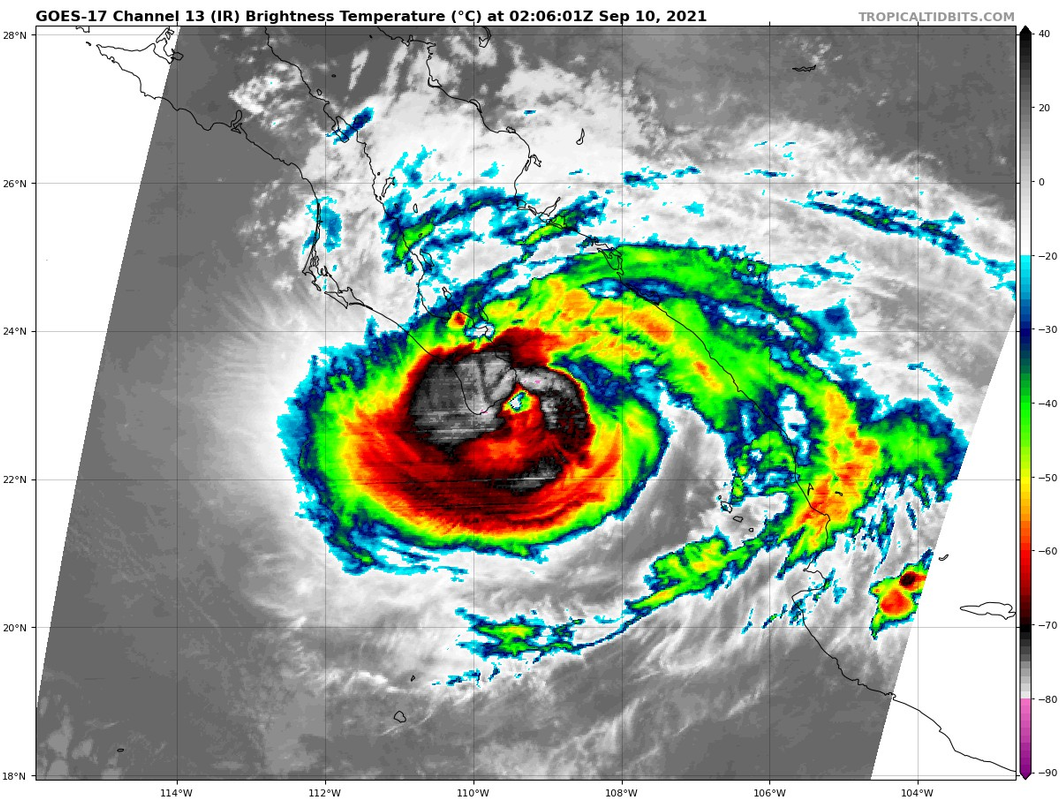
CIMSS ADT Raws jump to 6.0.
UW - CIMSS
ADVANCED DVORAK TECHNIQUE
ADT-Version 9.0
Tropical Cyclone Intensity Algorithm
----- Current Analysis -----
Date : 10 SEP 2021 Time : 015031 UTC
Lat : 22:57:35 N Lon : 109:26:24 W
CI# /Pressure/ Vmax
5.3 / 957.6mb/ 97.2kt
Final T# Adj T# Raw T#
5.3 5.9 6.0
Estimated radius of max. wind based on IR : 12 km
Center Temp : -5.1C Cloud Region Temp : -67.4C
Scene Type : EYE
Subtropical Adjustment : OFF
Extratropical Adjustment : OFF
Positioning Method : ARCHER POSITIONING
Ocean Basin : EAST PACIFIC
Dvorak CI > MSLP Conversion Used : CKZ Method
Tno/CI Rules : Constraint Limits : 1.3T/6hr
Weakening Flag : OFF
Rapid Dissipation Flag : OFF
Last edited by Kingarabian on Thu Sep 09, 2021 9:25 pm, edited 1 time in total.
0 likes
RIP Kobe Bryant
-
Yellow Evan
- Professional-Met
- Posts: 16242
- Age: 27
- Joined: Fri Jul 15, 2011 12:48 pm
- Location: Henderson, Nevada/Honolulu, HI
- Contact:
Re: EPAC: OLAF - Hurricane
grapealcoholic wrote:Probably sub 950 now
Absolutely not. If this was sub-950, there'd be a full W ring at minimum and/or a much warmer and circular eye.
7 likes
-
Kingarabian
- S2K Supporter
- Posts: 16373
- Joined: Sat Aug 08, 2009 3:06 am
- Location: Honolulu, Hawaii

-
Yellow Evan
- Professional-Met
- Posts: 16242
- Age: 27
- Joined: Fri Jul 15, 2011 12:48 pm
- Location: Henderson, Nevada/Honolulu, HI
- Contact:
-
Kingarabian
- S2K Supporter
- Posts: 16373
- Joined: Sat Aug 08, 2009 3:06 am
- Location: Honolulu, Hawaii
Re: EPAC: OLAF - Hurricane
Yellow Evan wrote:https://twitter.com/icyclone/status/1436153367932256268?s=21
https://twitter.com/iCyclone/status/1436154648696537114
Lol c'mon!
1 likes
RIP Kobe Bryant
-
toad strangler

- S2K Supporter
- Posts: 4546
- Joined: Sun Jul 28, 2013 3:09 pm
- Location: Earth
- Contact:
Re: EPAC: OLAF - Hurricane
Morgerman says Olaf is an angry 'cane. He loves that word but I believe him. Sounds like more than he expected.
0 likes
My Weather Station
https://www.wunderground.com/dashboard/pws/KFLPORTS603
https://www.wunderground.com/dashboard/pws/KFLPORTS603
-
grapealcoholic
- Category 2
- Posts: 703
- Joined: Tue Aug 10, 2021 3:26 pm

-
Yellow Evan
- Professional-Met
- Posts: 16242
- Age: 27
- Joined: Fri Jul 15, 2011 12:48 pm
- Location: Henderson, Nevada/Honolulu, HI
- Contact:
Re: EPAC: OLAF - Hurricane
Kingarabian wrote:Yellow Evan wrote:https://twitter.com/icyclone/status/1436153367932256268?s=21
https://twitter.com/iCyclone/status/1436154648696537114
Lol c'mon!
He should be able to convert his pressure to sea level by his elevation.
0 likes

Re: EPAC: OLAF - Hurricane
Not too long before radar swims with the fish.
0 likes
Personal Forecast Disclaimer:
The posts in this forum are NOT official forecast and should not be used as such. They are just the opinion of the poster and may or may not be backed by sound meteorological data. For official information, please refer to the NHC and NWS products.
The posts in this forum are NOT official forecast and should not be used as such. They are just the opinion of the poster and may or may not be backed by sound meteorological data. For official information, please refer to the NHC and NWS products.
-
grapealcoholic
- Category 2
- Posts: 703
- Joined: Tue Aug 10, 2021 3:26 pm
Who is online
Users browsing this forum: No registered users and 41 guests