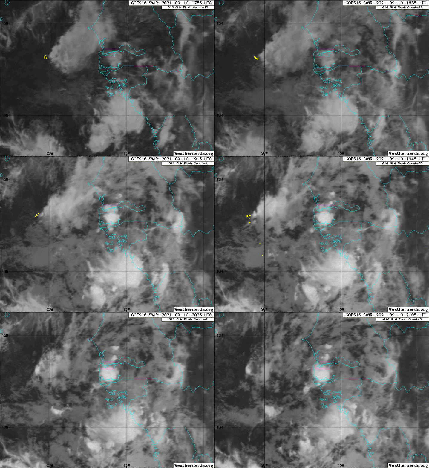
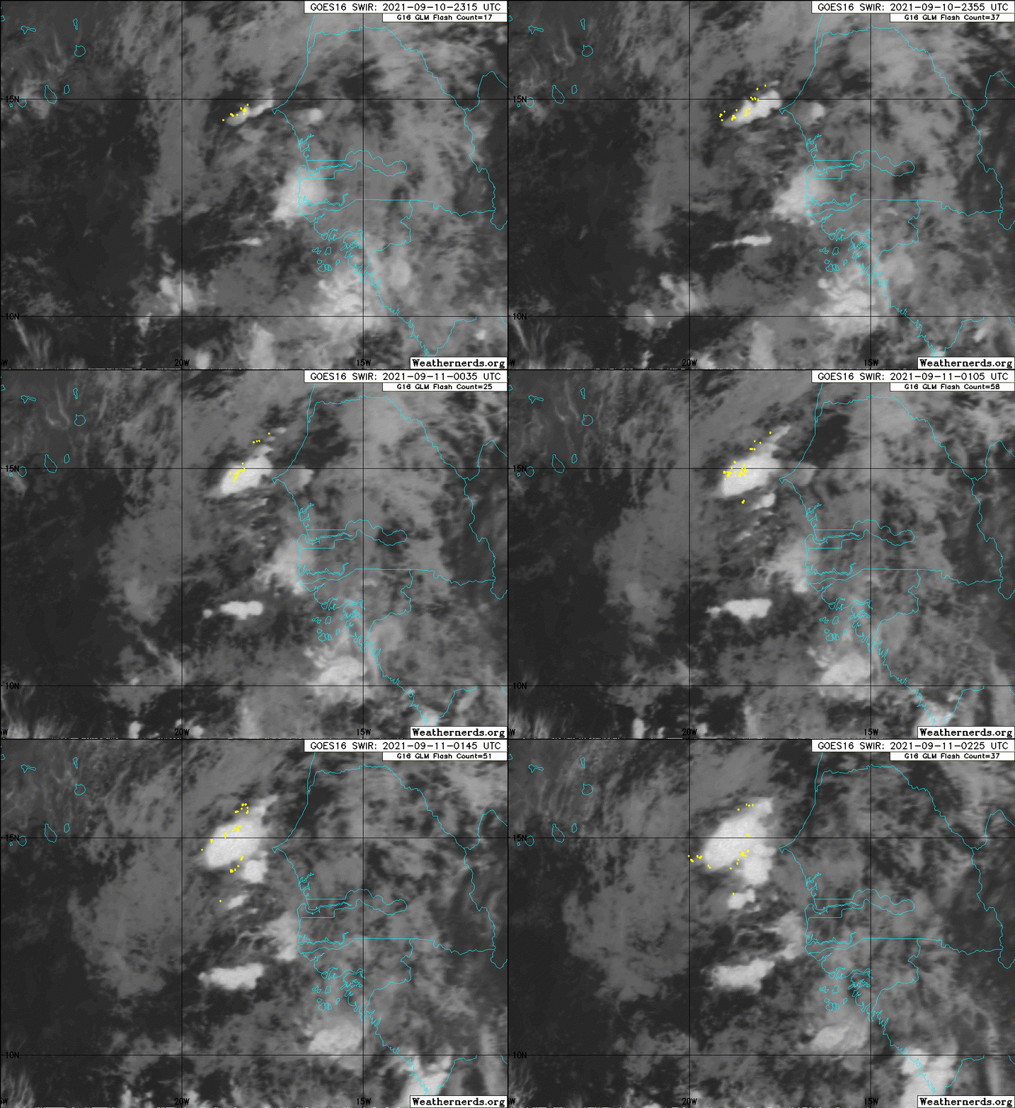
http://hurricanes.ral.ucar.edu/reposito ... 932021.dat
ATL: INVEST 93L - Discussion
Moderator: S2k Moderators
- cycloneye
- Admin

- Posts: 149555
- Age: 69
- Joined: Thu Oct 10, 2002 10:54 am
- Location: San Juan, Puerto Rico
ATL: INVEST 93L - Discussion
For the African Wave.
http://hurricanes.ral.ucar.edu/reposito ... 932021.dat
AL, 93, 2021091018, , BEST, 0, 118N, 153W, 25, 1010, DB, 34, NEQ, 0, 0, 0, 0, 1013, 120, 60, 0, 0, L, 0, , 0, 0, INVEST, S, 0, , 0, 0, 0, 0, genesis-num, 032, SPAWNINVEST, al752021 to al932021,
http://hurricanes.ral.ucar.edu/reposito ... 932021.dat
2 likes
Visit the Caribbean-Central America Weather Thread where you can find at first post web cams,radars
and observations from Caribbean basin members Click Here
and observations from Caribbean basin members Click Here
- AnnularCane
- S2K Supporter

- Posts: 2963
- Joined: Thu Jun 08, 2006 9:18 am
- Location: Wytheville, VA
Re: ATL: INVEST 93L - Discussion
Wow, I just clicked on this topic without even reading the title. Then it's "whoa, an invest!" 
Although I expected the other one to be declared first.
Although I expected the other one to be declared first.
0 likes
"But it never rained rain. It never snowed snow. And it never blew just wind. It rained things like soup and juice. It snowed mashed potatoes and green peas. And sometimes the wind blew in storms of hamburgers." -- Judi Barrett, Cloudy with a Chance of Meatballs
Re: ATL: INVEST 93L - Discussion
Now it’s a race to see who will become Nicholas. My hunch is that 93L will get it, unless it takes a while to develop and 94L develops quicker.
0 likes
Irene '11 Sandy '12 Hermine '16 5/15/2018 Derecho Fay '20 Isaias '20 Elsa '21 Henri '21 Ida '21
I am only a meteorology enthusiast who knows a decent amount about tropical cyclones. Look to the professional mets, the NHC, or your local weather office for the best information.
I am only a meteorology enthusiast who knows a decent amount about tropical cyclones. Look to the professional mets, the NHC, or your local weather office for the best information.
-
Sciencerocks
- Category 5

- Posts: 10186
- Age: 40
- Joined: Thu Jul 06, 2017 1:51 am
Re: ATL: INVEST 93L - Discussion
aspen wrote:Now it’s a race to see who will become Nicholas. My hunch is that 93L will get it, unless it takes a while to develop and 94L develops quicker.
Which one is 93L and 94L. I'm more interested in the one which is supposed to cruise along the Mexican and Texas coast.
0 likes
- AnnularCane
- S2K Supporter

- Posts: 2963
- Joined: Thu Jun 08, 2006 9:18 am
- Location: Wytheville, VA
Re: ATL: INVEST 93L - Discussion
hipshot wrote:aspen wrote:Now it’s a race to see who will become Nicholas. My hunch is that 93L will get it, unless it takes a while to develop and 94L develops quicker.
Which one is 93L and 94L. I'm more interested in the one which is supposed to cruise along the Mexican and Texas coast.
No 94L yet, but the one over the Yucatan should eventually be that one.
0 likes
"But it never rained rain. It never snowed snow. And it never blew just wind. It rained things like soup and juice. It snowed mashed potatoes and green peas. And sometimes the wind blew in storms of hamburgers." -- Judi Barrett, Cloudy with a Chance of Meatballs
Re: ATL: INVEST 93L - Discussion
hipshot wrote:aspen wrote:Now it’s a race to see who will become Nicholas. My hunch is that 93L will get it, unless it takes a while to develop and 94L develops quicker.
Which one is 93L and 94L. I'm more interested in the one which is supposed to cruise along the Mexican and Texas coast.
While it hasn’t been designated yet, the Yucatán wave will be 94L.
1 likes
Irene '11 Sandy '12 Hermine '16 5/15/2018 Derecho Fay '20 Isaias '20 Elsa '21 Henri '21 Ida '21
I am only a meteorology enthusiast who knows a decent amount about tropical cyclones. Look to the professional mets, the NHC, or your local weather office for the best information.
I am only a meteorology enthusiast who knows a decent amount about tropical cyclones. Look to the professional mets, the NHC, or your local weather office for the best information.
- ouragans
- Category 2

- Posts: 501
- Age: 54
- Joined: Sun Jun 12, 2011 12:09 pm
- Location: Abymes, Guadeloupe F.W.I
- Contact:
Re: ATL: INVEST 93L - Discussion
Invest 93L
As of 18:00 UTC Sep 10, 2021:
Location: 11.8°N 15.3°W
Maximum Winds: 25 kt Gusts: N/A
Minimum Central Pressure: 1010 mb
Environmental Pressure: N/A
Radius of Circulation: N/A
Radius of Maximum wind: 60 nm
As of 18:00 UTC Sep 10, 2021:
Location: 11.8°N 15.3°W
Maximum Winds: 25 kt Gusts: N/A
Minimum Central Pressure: 1010 mb
Environmental Pressure: N/A
Radius of Circulation: N/A
Radius of Maximum wind: 60 nm
1 likes
Personal forecast disclaimer
This post is a personal point of view, not an information. Please refer to official statements for life-threatening decisions.
David '79, Frederic '79, Hugo '89, Iris, Luis & Marilyn '95, Georges '98, Lenny '99, Dean '07, Irma '17, Maria '17, Fiona '22, Philippe '23, Tammy '23
16°13'33.3,"6N -61°36'39.5"W
Re: ATL: INVEST 93L - Discussion
Still at 50/70 for the 8pm TWO, but the 5-day development cone has shifted further SW.
1 likes
Irene '11 Sandy '12 Hermine '16 5/15/2018 Derecho Fay '20 Isaias '20 Elsa '21 Henri '21 Ida '21
I am only a meteorology enthusiast who knows a decent amount about tropical cyclones. Look to the professional mets, the NHC, or your local weather office for the best information.
I am only a meteorology enthusiast who knows a decent amount about tropical cyclones. Look to the professional mets, the NHC, or your local weather office for the best information.
Re: ATL: INVEST 93L - Discussion
ouragans wrote:Invest 93L
As of 18:00 UTC Sep 10, 2021:
Location: 11.8°N 15.3°W
Maximum Winds: 25 kt Gusts: N/A
Minimum Central Pressure: 1010 mb
Environmental Pressure: N/A
Radius of Circulation: N/A
Radius of Maximum wind: 60 nm
Note how far south they have it! I didn’t expect that. If that’s where the real main LLC is, that is almost for sure NOT going to recurve sharply. That’s much further south than the convective ball I was following earlier, which was up near 14N.
Also, note that the red area is oriented further south as was just noted. That’s likely because the Euro abruptly dropped its quick recurve at 12z (and on 18Z, too).
1 likes
Personal Forecast Disclaimer:
The posts in this forum are NOT official forecasts and should not be used as such. They are just the opinion of the poster and may or may not be backed by sound meteorological data. They are NOT endorsed by any professional institution or storm2k.org. For official information, please refer to the NHC and NWS products.
The posts in this forum are NOT official forecasts and should not be used as such. They are just the opinion of the poster and may or may not be backed by sound meteorological data. They are NOT endorsed by any professional institution or storm2k.org. For official information, please refer to the NHC and NWS products.
- cycloneye
- Admin

- Posts: 149555
- Age: 69
- Joined: Thu Oct 10, 2002 10:54 am
- Location: San Juan, Puerto Rico
Re: ATL: INVEST 93L - Discussion
00z Best Track:
AL, 93, 2021091100, , BEST, 0, 127N, 172W, 25, 1010, DB
0 likes
Visit the Caribbean-Central America Weather Thread where you can find at first post web cams,radars
and observations from Caribbean basin members Click Here
and observations from Caribbean basin members Click Here
- ElectricStorm
- Category 5

- Posts: 5148
- Age: 25
- Joined: Tue Aug 13, 2019 11:23 pm
- Location: Norman, OK
Re: ATL: INVEST 93L - Discussion
Not 100% recurve IMO, lots of possibilities here. Hopefully it goes OTS but we'll see.
0 likes
B.S Meteorology, University of Oklahoma '25
Please refer to the NHC, NWS, or SPC for official information.
Please refer to the NHC, NWS, or SPC for official information.
-
CrazyC83
- Professional-Met

- Posts: 34315
- Joined: Tue Mar 07, 2006 11:57 pm
- Location: Deep South, for the first time!
Re: ATL: INVEST 93L - Discussion
It seems the models are not too impressed with this though. Poor conditions ahead?
0 likes
-
Sciencerocks
- Category 5

- Posts: 10186
- Age: 40
- Joined: Thu Jul 06, 2017 1:51 am
Re: ATL: INVEST 93L - Discussion
CrazyC83 wrote:It seems the models are not too impressed with this though. Poor conditions ahead?
Is this the storm that GFS has been showing off Florida moving north towards GA/SC in 10 days time?
0 likes
Andrew (1992), Irene (1999), Frances (2004), Katrina (2005), Wilma (2005), Fay (2008), Irma (2017), Eta (2020), Ian (2022)
Re: ATL: INVEST 93L - Discussion
CrazyC83 wrote:It seems the models are not too impressed with this though. Poor conditions ahead?
Not expecting much from 93L, but what's concerning is that it could create better conditions for the low-rider behind it.
0 likes
TC naming lists: retirements and intensity
Most aggressive Advisory #1's in North Atlantic (cr. kevin for starting the list)
Most aggressive Advisory #1's in North Atlantic (cr. kevin for starting the list)
-
CrazyC83
- Professional-Met

- Posts: 34315
- Joined: Tue Mar 07, 2006 11:57 pm
- Location: Deep South, for the first time!
Re: ATL: INVEST 93L - Discussion
Teban54 wrote:CrazyC83 wrote:It seems the models are not too impressed with this though. Poor conditions ahead?
Not expecting much from 93L, but what's concerning is that it could create better conditions for the low-rider behind it.
That's what I'm thinking. 95L will be a bigger one to watch.
1 likes
-
AlphaToOmega
- Category 5

- Posts: 1448
- Joined: Sat Jun 26, 2021 10:51 am
- Location: Somewhere in Massachusetts
Re: ATL: INVEST 93L - Discussion
Do not discount this wave. As Julian can tell you, waves can develop when you least expect it. Ensembles support development, and conditions are conducive. I think a tropical storm is likely.
0 likes
-
AlphaToOmega
- Category 5

- Posts: 1448
- Joined: Sat Jun 26, 2021 10:51 am
- Location: Somewhere in Massachusetts
Re: ATL: INVEST 93L - Discussion
CrazyC83 wrote:It seems the models are not too impressed with this though. Poor conditions ahead?
Ensembles are still impressed
0 likes
Re: ATL: INVEST 93L - Discussion
AlphaToOmega wrote:CrazyC83 wrote:It seems the models are not too impressed with this though. Poor conditions ahead?
Ensembles are still impressed
https://i.imgur.com/9TkJh0u.png
I know this is the discussion, but it seems that yes ensembles do support but it looks like AOI below 93L is getting the majority of support, then again I could be mistaken.
0 likes
Once I see the REDS and GREENS Converge on a Base Velocity. ... I'm There!!
This is NOT an Official Forecast....Just my Opinion. For official information, please refer to the NHC and NWS products.
HIGHLIGHTS : '13 El Reno Tornado : 2013 Storm Chaser Tour, Joaquin; SC flood event, Matthew '16, Lowcountry Snow storm Jan '18
This is NOT an Official Forecast....Just my Opinion. For official information, please refer to the NHC and NWS products.
HIGHLIGHTS : '13 El Reno Tornado : 2013 Storm Chaser Tour, Joaquin; SC flood event, Matthew '16, Lowcountry Snow storm Jan '18
Who is online
Users browsing this forum: No registered users and 75 guests


