
http://ntv.ca/web-cams/downtown-cam/
http://ntv.ca/web-cams/pub-cam/
Downtown St. Johns.
ATL: LARRY - Post-Tropical - Discussion
Moderator: S2k Moderators
Re: ATL: LARRY - Hurricane - Discussion
0 likes
Personal Forecast Disclaimer:
The posts in this forum are NOT official forecast and should not be used as such. They are just the opinion of the poster and may or may not be backed by sound meteorological data. For official information, please refer to the NHC and NWS products.
The posts in this forum are NOT official forecast and should not be used as such. They are just the opinion of the poster and may or may not be backed by sound meteorological data. For official information, please refer to the NHC and NWS products.
-
cycloneye

- Admin

- Posts: 149505
- Age: 69
- Joined: Thu Oct 10, 2002 10:54 am
- Location: San Juan, Puerto Rico
Re: ATL: LARRY - Hurricane - Discussion
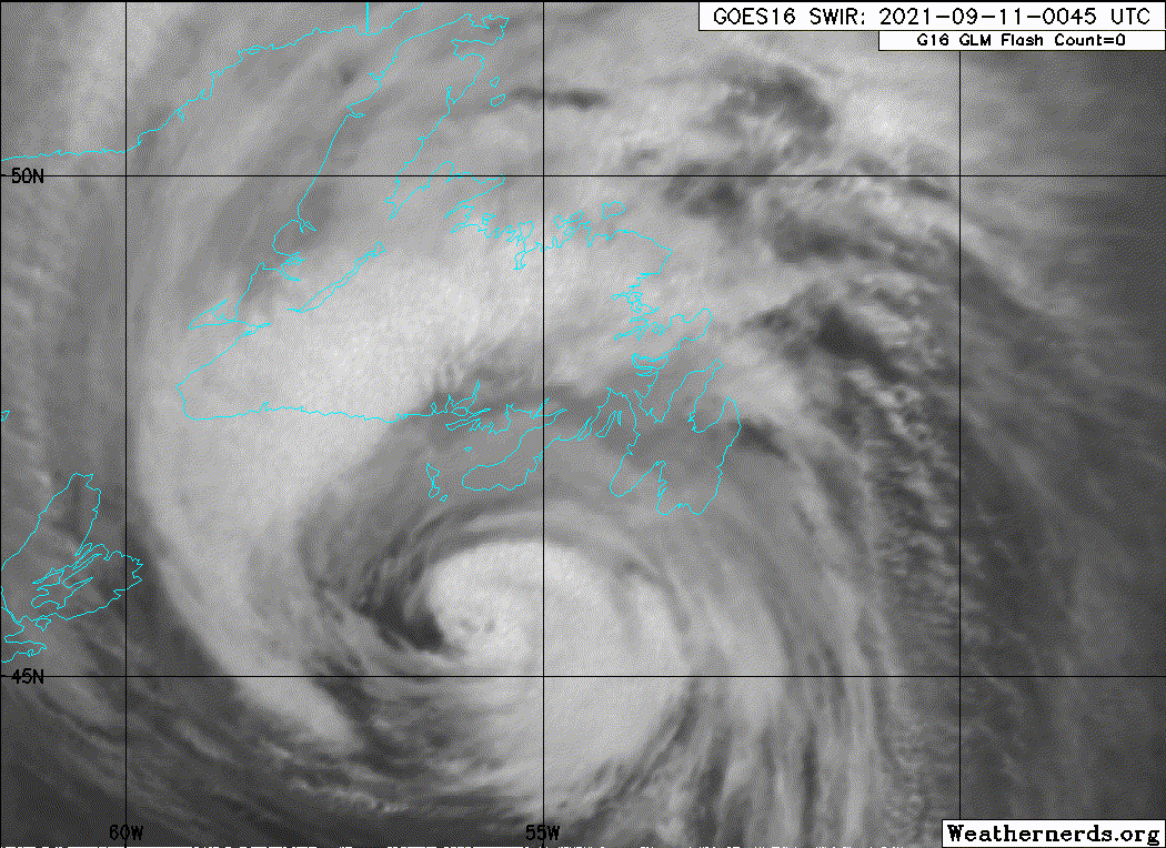
Hurricane Larry Tropical Cyclone Update
NWS National Hurricane Center Miami FL AL122021
1150 PM AST Fri Sep 10 2021
...LARRY MAKES LANDFALL ON NEWFOUNDLAND...
Recent satellite, radar and surface data indicate that Larry has
made landfall in Newfoundland near South East Bight at 1145 PM AST
(0345 UTC), with maximum sustained winds of 80 mph (130 km/h) and
an estimated minimum pressure of 960 mb (28.35 inches).
SUMMARY OF 1150 PM AST...0350 UTC...INFORMATION
----------------------------------------------
LOCATION...47.4N 54.5W
ABOUT 85 MI...135 KM WSW OF ST JOHNS NEWFOUNDLAND
MAXIMUM SUSTAINED WINDS...80 MPH...130 KM/H
PRESENT MOVEMENT...NNE OR 030 DEGREES AT 47 MPH...76 KM/H
MINIMUM CENTRAL PRESSURE...960 MB...28.35 INCHES
$$
Forecaster Blake
1 likes
Visit the Caribbean-Central America Weather Thread where you can find at first post web cams,radars
and observations from Caribbean basin members Click Here
and observations from Caribbean basin members Click Here
-
CrazyC83
- Professional-Met

- Posts: 34315
- Joined: Tue Mar 07, 2006 11:57 pm
- Location: Deep South, for the first time!
Re: ATL: LARRY - Hurricane - Discussion
47.4N is about the same latitude as the northernmost tip of Maine, or around Grand Forks, ND. That is more than 2,500 miles north of the Windward Islands, to consider the range in the Atlantic basin.
5 likes
-
supercane4867
- Category 5

- Posts: 4966
- Joined: Wed Nov 14, 2012 10:43 am
Re: ATL: LARRY - Hurricane - Discussion
Officially the first hurricane landfall in Newfoundland since Igor of 11 years ago.
4 likes
-
Sciencerocks
- Category 5
- Posts: 10186
- Age: 40
- Joined: Thu Jul 06, 2017 1:51 am
-
CrazyC83
- Professional-Met
- Posts: 34315
- Joined: Tue Mar 07, 2006 11:57 pm
- Location: Deep South, for the first time!
Re: ATL: LARRY - Hurricane - Discussion
Wind impact looks like it is greater than Igor, although there doesn't appear to be nearly as much rainfall. One big difference is that Igor hit during the daytime, while this is at night - almost reminiscent of Hurricane Juan.
0 likes
-
TheDreamTraveler

- Category 2

- Posts: 645
- Joined: Sun Aug 22, 2010 3:10 am
- Location: PA
Re: ATL: LARRY - Hurricane - Discussion
Weather Dude wrote:supercane4867 wrote:11PM advisory still keeps it as tropical. Clearly we have a hurricane landfall
...CENTER OF LARRY TO MOVE OVER SOUTHEASTERN NEWFOUNDLAND DURING THE NEXT FEW HOURS... ...EXPECTED TO BRING HURRICANE-FORCE WINDS, A DANGEROUS STORM SURGE, AND HEAVY RAINFALL TO THAT AREA TONIGHT...
11:00 PM AST Fri Sep 10
Location: 46.8°N 54.9°W
Moving: NNE at 47 mph
Min pressure: 958 mb
Max sustained: 80 mph
I think 958mb is the lowest I have ever seen for a Cat 1. Wow
Hurricane Sandy was at a lower pressure while still classified as a cat 1 hurricane but yeah this is definitely one of the most extreme cases. Igor was also at a similar pressure
0 likes
-
CrazyC83
- Professional-Met
- Posts: 34315
- Joined: Tue Mar 07, 2006 11:57 pm
- Location: Deep South, for the first time!
Re: ATL: LARRY - Hurricane - Discussion
The metro area of St. John's has a population of 220,000. They are clearly experiencing hurricane conditions right now.
0 likes
-
PavelGaborik
- Tropical Depression

- Posts: 81
- Joined: Thu Oct 06, 2016 11:13 pm
Re: ATL: LARRY - Hurricane - Discussion
St. Johns hasn't had winds this strong in four years. That may not seem like long but when you consider the incredibly powerful Nor' Easters that impact Atlantic Canada on a yearly basis that is quite significant.
0 likes
-
CrazyC83
- Professional-Met
- Posts: 34315
- Joined: Tue Mar 07, 2006 11:57 pm
- Location: Deep South, for the first time!
Re: ATL: LARRY - Hurricane - Discussion
PavelGaborik wrote:St. Johns hasn't had winds this strong in four years. That may not seem like long but when you consider the incredibly powerful Nor' Easters that impact Atlantic Canada on a yearly basis that is quite significant.
Nor'easters also don't hit when trees are in full leaf. That magnifies the damage when it happens during the summer or early fall.
0 likes
-
CrazyC83
- Professional-Met
- Posts: 34315
- Joined: Tue Mar 07, 2006 11:57 pm
- Location: Deep South, for the first time!
Re: ATL: LARRY - Hurricane - Discussion
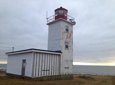
https://twitter.com/weathernetwork/status/1436552063773814785
The gust in Cape St. Mary may have been at an elevated site. Still, that is 113 mph.
The gust in Cape St. Mary may have been at an elevated site. Still, that is 113 mph.
4 likes
-
CrazyC83
- Professional-Met
- Posts: 34315
- Joined: Tue Mar 07, 2006 11:57 pm
- Location: Deep South, for the first time!
Re: ATL: LARRY - Hurricane - Discussion
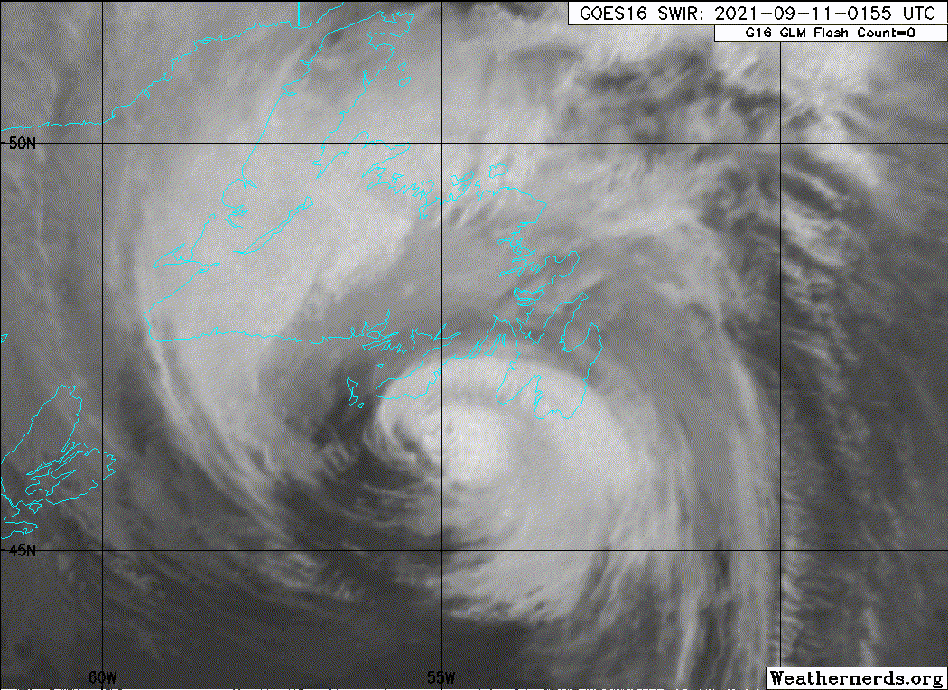
How quick is Larry moving? The center has almost cleared the island already.
It should quickly spin down to post-tropical in the next few hours. Water temperatures northeast of Newfoundland are literally freezing.
It should quickly spin down to post-tropical in the next few hours. Water temperatures northeast of Newfoundland are literally freezing.
1 likes
-
PavelGaborik
- Tropical Depression
- Posts: 81
- Joined: Thu Oct 06, 2016 11:13 pm
Re: ATL: LARRY - Hurricane - Discussion
CrazyC83 wrote:PavelGaborik wrote:St. Johns hasn't had winds this strong in four years. That may not seem like long but when you consider the incredibly powerful Nor' Easters that impact Atlantic Canada on a yearly basis that is quite significant.
Nor'easters also don't hit when trees are in full leaf. That magnifies the damage when it happens during the summer or early fall.
Yes foliage should lead to a decent amount of damage windwise, fortunately it appears Larry is already on his way out of Newfoundland.
Unlikely it'll be as impactful as Igor overall due to the lack of rainfall but it did look to produce slightly stronger winds from the data I've seen.
0 likes
-
Sciencerocks
- Category 5
- Posts: 10186
- Age: 40
- Joined: Thu Jul 06, 2017 1:51 am
-
Supersoaker
- Tropical Wave

- Posts: 6
- Joined: Fri Aug 27, 2021 9:13 pm
Re: ATL: LARRY - Hurricane - Discussion
CrazyC83 wrote:47.4N is about the same latitude as the northernmost tip of Maine, or around Grand Forks, ND. That is more than 2,500 miles north of the Windward Islands, to consider the range in the Atlantic basin.
I live in a major US city only barely north of 47.4, so wild to me that such a tropical system can make it so far
0 likes
-
EquusStorm
- Category 5
- Posts: 1649
- Age: 35
- Joined: Thu Nov 07, 2013 1:04 pm
- Location: Jasper, AL
- Contact:
Re: ATL: LARRY - Hurricane - Discussion
Didn't take him long at all to sweep across. Likely losing tropical characteristics right now.

0 likes
Colors of lost purpose on the canvas of irrelevance
Not a meteorologist, in fact more of an idiot than anything. You should probably check with the NHC or a local NWS office for official information.
Not a meteorologist, in fact more of an idiot than anything. You should probably check with the NHC or a local NWS office for official information.
-
CrazyC83
- Professional-Met
- Posts: 34315
- Joined: Tue Mar 07, 2006 11:57 pm
- Location: Deep South, for the first time!
Re: ATL: LARRY - Hurricane - Discussion
Center is just off Bonavista now on the northeast corner of that peninsula. That band still has a partial eyewall look though, although it is probably tilted with height. It should still be considered tropical for the 06Z synoptic time position, but probably will be extratropical at the next advisory and maybe a non-synoptic time at 09Z, or certainly by 12Z.
The Cape St. Mary station I'd want to see both the sustaining period (1-min vs. 10-min?) and the elevation. Based on all the data I have seen, 75 kt seems like what I would have set the landfall intensity at, although that station could bump it up to 80 kt.
The Cape St. Mary station I'd want to see both the sustaining period (1-min vs. 10-min?) and the elevation. Based on all the data I have seen, 75 kt seems like what I would have set the landfall intensity at, although that station could bump it up to 80 kt.
0 likes
-
supercane4867
- Category 5
- Posts: 4966
- Joined: Wed Nov 14, 2012 10:43 am
Re: ATL: LARRY - Hurricane - Discussion
The private weather station at Cape St. Mary's Lighthouse that recorded 98kt gust is not horribly elevated. According to the Canadian government website, the lighthouse itself is only 8.7 meters tall and built very close to sea level.
0 likes
Who is online
Users browsing this forum: No registered users and 45 guests