
https://twitter.com/webberweather/status/1436737433509380099
2021 Indicators: SST's / SAL / MSLP / Shear / Steering / Instability / Sat Images
Moderator: S2k Moderators
Forum rules

The posts in this forum are NOT official forecasts and should not be used as such. They are just the opinion of the poster and may or may not be backed by sound meteorological data. They are NOT endorsed by any professional institution or STORM2K. For official information, please refer to products from the National Hurricane Center and National Weather Service.
Re: 2021 Indicators: SST's / SAL / MSLP / Shear / Steering / Instability / Sat Images
It looks like our peak season relative "break" is about to end as we begin descending from the peak of climo mountain.
3 likes
-
toad strangler

- S2K Supporter

- Posts: 4546
- Joined: Sun Jul 28, 2013 3:09 pm
- Location: Earth
- Contact:
-
tolakram
- Admin

- Posts: 20186
- Age: 62
- Joined: Sun Aug 27, 2006 8:23 pm
- Location: Florence, KY (name is Mark)
Re: 2021 Indicators: SST's / SAL / MSLP / Shear / Steering / Instability / Sat Images
Sept 6th:
Just bringing this back, since you seem to be on the bear attack again. Please differentiate between those calling for less than hyperactive and those calling for a dead September, there's a difference. I appreciate you trying to give evidence as to your over the top predictions, I really do, but just because I predict lower numbers doesn't mean I'm some kind of bear.
Models are starting to pick up on some close in development, so your prediction is NOT impossible, but I still feel like it's unlikely. We will find out!
AlphaToOmega wrote:Let me repeat it again: just because we do not see activity in the next few days DOES NOT mean September will be dead. As shown a few weeks ago, lots of storms can form within a very short amount of time (~2 weeks). I expect a couple storms (2-3) to form before September 15, but I think September 15-30 will see 5-8 storms. No matter how you slice it, you cannot fight against the climatological peak of hurricane season. Therefore, I still think September as a whole will be very active, just like in 2007, 2010, 2018, 2019, and 2020.
Just bringing this back, since you seem to be on the bear attack again. Please differentiate between those calling for less than hyperactive and those calling for a dead September, there's a difference.
Models are starting to pick up on some close in development, so your prediction is NOT impossible, but I still feel like it's unlikely. We will find out!
6 likes
M a r k
- - - - -
Join us in chat: Storm2K Chatroom Invite. Android and IOS apps also available.
The posts in this forum are NOT official forecasts and should not be used as such. Posts are NOT endorsed by any professional institution or STORM2K.org. For official information and forecasts, please refer to NHC and NWS products.


Re: 2021 Indicators: SST's / SAL / MSLP / Shear / Steering / Instability / Sat Images


While I know it is only one model, which happens to be the CFS, this run is definitely not team U.S. This next low rider is going to have one hell of a time trying to track OTS if this verifies and it is weaker at first due to the -CCKW passing through that's all I am saying

4 likes
-
tolakram
- Admin
- Posts: 20186
- Age: 62
- Joined: Sun Aug 27, 2006 8:23 pm
- Location: Florence, KY (name is Mark)
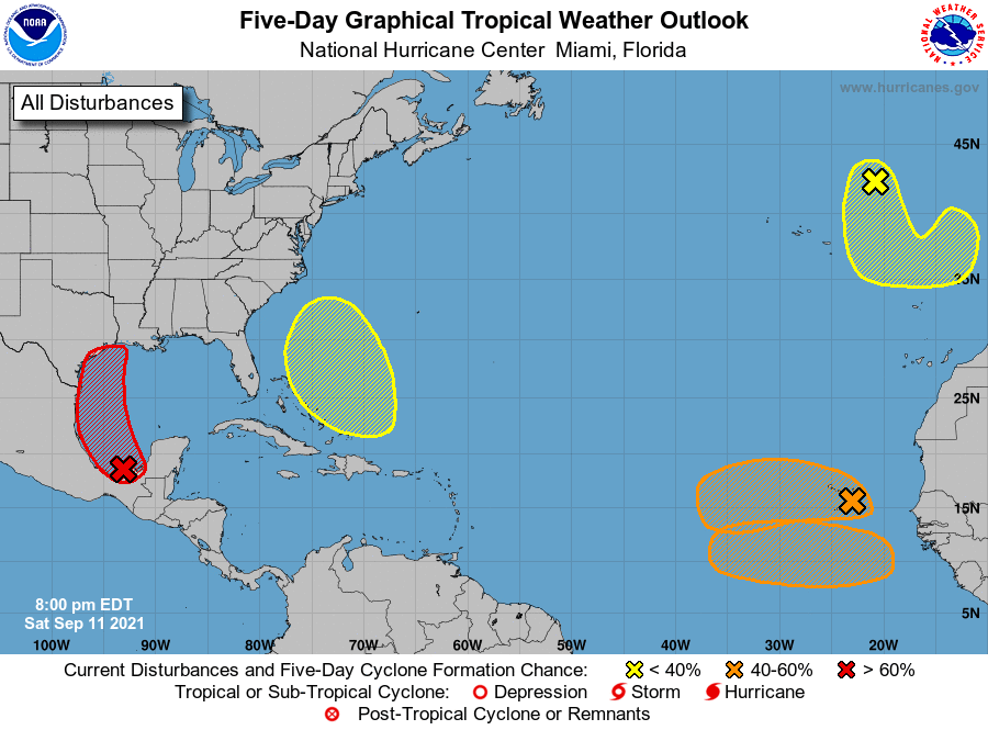
Re: 2021 Indicators: SST's / SAL / MSLP / Shear / Steering / Instability / Sat Images
Saved the current 5 day map

9 likes
M a r k
- - - - -
Join us in chat: Storm2K Chatroom Invite. Android and IOS apps also available.
The posts in this forum are NOT official forecasts and should not be used as such. Posts are NOT endorsed by any professional institution or STORM2K.org. For official information and forecasts, please refer to NHC and NWS products.
- - - - -
Join us in chat: Storm2K Chatroom Invite. Android and IOS apps also available.
The posts in this forum are NOT official forecasts and should not be used as such. Posts are NOT endorsed by any professional institution or STORM2K.org. For official information and forecasts, please refer to NHC and NWS products.
-
Category5Kaiju

- Category 5

- Posts: 4336
- Joined: Thu Dec 24, 2020 12:45 pm
- Location: Seattle during the summer, Phoenix during the winter
Re: 2021 Indicators: SST's / SAL / MSLP / Shear / Steering / Instability / Sat Images
So if all of those AOIs form we would conceivably be on Sam by the end of this month, with October and November to go. Looks like we are going to have to get out the aux list pretty soon
1 likes
Unless explicitly stated, all information in my posts is based on my own opinions and observations. Tropical storms and hurricanes can be extremely dangerous. Refer to an accredited weather research agency or meteorologist if you need to make serious decisions regarding an approaching storm.

Re: 2021 Indicators: SST's / SAL / MSLP / Shear / Steering / Instability / Sat Images
Category5Kaiju wrote:
So if all of those AOIs form we would conceivably be on Sam by the end of this month, with October and November to go. Looks like we are going to have to get out the aux list pretty soon
Yep and even if not all of these form it's only the 11th of September now, there's still 20 more days for new AOIs to develop and I'm quite confident that they will. I can understand why some people were kind of iffy on an active September at the start of the month (I was also a bit shocked at the lack of future activity in the models earlier this month), but tbh I wouldn't be surprised at this point if we end the month with 5 - 6 NS (counting Larry as an August storm). Not really a quiet September after all. Also note that 2017 'only' had 4 September storms (Irma formed on August 30), so besides the number of storms I think the impact of those storms is a really big factor in terms of how active they are perceived.
1 likes


Re: 2021 Indicators: SST's / SAL / MSLP / Shear / Steering / Instability / Sat Images
I decided the check the NHC outlook archives to see when the last true lull was. It was August 2nd at 8am. Every single outlook since then has featured atleast one active storm or AOI.
For comparison, 2020 had a streak from August 7th to September 25th.
Streaks of this extent aren't usual, but because we have had so many freakish years recently it just feels normal.

For comparison, 2020 had a streak from August 7th to September 25th.
Streaks of this extent aren't usual, but because we have had so many freakish years recently it just feels normal.
4 likes
-
SconnieCane
- Category 5
- Posts: 1013
- Joined: Thu Aug 02, 2018 5:29 pm
- Location: Madison, WI
Re: 2021 Indicators: SST's / SAL / MSLP / Shear / Steering / Instability / Sat Images
Interesting how we're once again discussing the influence a WPAC TC can have on Atlantic ones that haven't even formed yet, this time regarding track. Last season it was about them influencing the formation of TUTTS in the Atlantic which created VWS.
3 likes
-
AlphaToOmega
- Category 5
- Posts: 1448
- Joined: Sat Jun 26, 2021 10:51 am
- Location: Somewhere in Massachusetts
Re: 2021 Indicators: SST's / SAL / MSLP / Shear / Steering / Instability / Sat Images
000
ABNT20 KNHC 112338
TWOAT
Tropical Weather Outlook
NWS National Hurricane Center Miami FL
800 PM EDT Sat Sep 11 2021
For the North Atlantic...Caribbean Sea and the Gulf of Mexico:
A tropical wave and an upper-level trough continue to produce a
large area of disorganized showers and thunderstorms over portions
of southeastern Mexico and the southern and central Gulf of Mexico.
Upper-level winds are gradually becoming more conducive for
development, and a tropical depression is likely to form on Sunday
or Monday while the disturbance moves northwestward and then
northward near the coast of northeastern Mexico. Additional
development will be possible through the middle of next week if the
system remains over water, and interests along the western and
northwestern Gulf coast should monitor the progress of this system.
An Air Force Hurricane Hunter aircraft is scheduled to investigate
the system tomorrow, if necessary.
Regardless of development, this disturbance will continue to produce
heavy rain across portions of southern Mexico, including the western
Yucatan Peninsula, through tonight which may lead to flash flooding
and mudslides. By late Sunday, heavy rain is expected to reach
portions of the Texas and Louisiana coasts with a heavy rain threat
then continuing across those coasts through the middle of next week.
Localized significant rainfall amounts are possible, potentially
resulting in areas of flash, urban, and isolated river flooding.
* Formation chance through 48 hours...high...90 percent.
* Formation chance through 5 days...high...90 percent.
Showers and thunderstorms remain poorly organized in association
with a tropical wave located near the Cabo Verde Islands.
Environmental conditions are currently conducive for development,
and a tropical depression could still form this weekend or early
next week while the system moves westward over the far eastern
Atlantic. By the middle of next week, stronger upper-level winds and
marginally warm ocean temperatures are expected to limit additional
development. Regardless of development, this disturbance is likely
to bring gusty winds and locally heavy rain across the Cabo Verde
Islands tonight.
* Formation chance through 48 hours...medium...50 percent.
* Formation chance through 5 days...medium...50 percent.
Another tropical wave is expected to move off the west coast of
Africa in a few days. Gradual development of this system is possible
thereafter, and a tropical depression could from by the middle of
next week while it moves westward across the eastern tropical
Atlantic Ocean.
* Formation chance through 48 hours...low...near 0 percent.
* Formation chance through 5 days...medium...40 percent.
An area of low pressure is expected to form near the southeastern
Bahamas in a few days resulting from moisture by a tropical wave
interacting with an upper-level trough. Gradual development of this
system is possible thereafter as it moves northwestward across the
western Atlantic.
* Formation chance through 48 hours...low...near 0 percent.
* Formation chance through 5 days...low...30 percent.
A non-tropical area of low pressure is located over the far
northeastern Atlantic several hundred miles northeast of the
Azores. This system is forecast to move south-southeastward towards
warmer waters, which could allow the low to gradually acquire some
tropical or subtropical characteristics by the middle of next week.
* Formation chance through 48 hours...low...10 percent.
* Formation chance through 5 days...low...20 percent.
$$
Forecaster Papin
1 likes

Re: 2021 Indicators: SST's / SAL / MSLP / Shear / Steering / Instability / Sat Images
Well, that escalated quickly. They just keep popping up like rabbits.
1 likes
Irene '11 Sandy '12 Hermine '16 5/15/2018 Derecho Fay '20 Isaias '20 Elsa '21 Henri '21 Ida '21
I am only a meteorology enthusiast who knows a decent amount about tropical cyclones. Look to the professional mets, the NHC, or your local weather office for the best information.
I am only a meteorology enthusiast who knows a decent amount about tropical cyclones. Look to the professional mets, the NHC, or your local weather office for the best information.
-
Deshaunrob17
- Tropical Storm

- Posts: 211
- Joined: Tue Aug 18, 2020 7:49 am
Re: 2021 Indicators: SST's / SAL / MSLP / Shear / Steering / Instability / Sat Images
Euro was super bullish on a storm / hurricane hitting the Cabo Verde Islands... Thankfully, wrong....
1 likes


Re: 2021 Indicators: SST's / SAL / MSLP / Shear / Steering / Instability / Sat Images
Deshaunrob17 wrote:Euro was super bullish on a storm / hurricane hitting the Cabo Verde Islands... Thankfully, wrong....
Wasn't that the one that looked to recurve right off the coast originally?
0 likes
-
Category5Kaiju
- Category 5
- Posts: 4336
- Joined: Thu Dec 24, 2020 12:45 pm
- Location: Seattle during the summer, Phoenix during the winter
Re: 2021 Indicators: SST's / SAL / MSLP / Shear / Steering / Instability / Sat Images
We now have 5 AOIs. Wow.
1 likes
Unless explicitly stated, all information in my posts is based on my own opinions and observations. Tropical storms and hurricanes can be extremely dangerous. Refer to an accredited weather research agency or meteorologist if you need to make serious decisions regarding an approaching storm.
-
AlphaToOmega
- Category 5
- Posts: 1448
- Joined: Sat Jun 26, 2021 10:51 am
- Location: Somewhere in Massachusetts
-
SconnieCane
- Category 5
- Posts: 1013
- Joined: Thu Aug 02, 2018 5:29 pm
- Location: Madison, WI
Re: 2021 Indicators: SST's / SAL / MSLP / Shear / Steering / Instability / Sat Images
AlphaToOmega wrote:https://i.postimg.cc/261GMQrW/two-atl-5d0.png
Hmmmmm...first (northern) AEW (93L) went back down to "Medium."
0 likes
-
AlphaToOmega
- Category 5
- Posts: 1448
- Joined: Sat Jun 26, 2021 10:51 am
- Location: Somewhere in Massachusetts
Re: 2021 Indicators: SST's / SAL / MSLP / Shear / Steering / Instability / Sat Images
SconnieCane wrote:AlphaToOmega wrote:https://i.postimg.cc/261GMQrW/two-atl-5d0.png
Hmmmmm...first (northern) AEW (93L) went back down to "Medium."
48-hour chances did not change.
Only 5-day chances changed.
This could be a sleeper wave.
1 likes

Re: 2021 Indicators: SST's / SAL / MSLP / Shear / Steering / Instability / Sat Images
AlphaToOmega wrote:https://i.postimg.cc/261GMQrW/two-atl-5d0.png
And this is in a suppressed CCKW...
0 likes
TC naming lists: retirements and intensity
Most aggressive Advisory #1's in North Atlantic (cr. kevin for starting the list)
Most aggressive Advisory #1's in North Atlantic (cr. kevin for starting the list)
-
Category5Kaiju
- Category 5
- Posts: 4336
- Joined: Thu Dec 24, 2020 12:45 pm
- Location: Seattle during the summer, Phoenix during the winter
Re: 2021 Indicators: SST's / SAL / MSLP / Shear / Steering / Instability / Sat Images
While I do not expect 2021 to do the same in any way and expect an active October (similar to 2020, though strength and quantity-wise I am not very sure how well they will mirror one another) given our direction toward a solid La Nina, was there a reason why 2017, which was also a destructive and active year headed towards a La Nina, suddenly shut down after Nate/Ophelia in October, with not much quality activity occurring afterwards?
4 likes
Unless explicitly stated, all information in my posts is based on my own opinions and observations. Tropical storms and hurricanes can be extremely dangerous. Refer to an accredited weather research agency or meteorologist if you need to make serious decisions regarding an approaching storm.
Who is online
Users browsing this forum: xtyphooncyclonex and 102 guests