ATL: NICHOLAS - Post-Tropical - Discussion
Moderator: S2k Moderators
-
jaguars_22
- Category 2

- Posts: 629
- Joined: Tue Jun 20, 2017 2:26 pm
- Location: Victoria TX
Re: ATL: FOURTEEN - Potential Tropical Cyclone - Discussion
Icy tundra should us in Victoria start preparing? Boarding up? What’s your gut instinct
0 likes
-
Category5Kaiju

- Category 5

- Posts: 4336
- Joined: Thu Dec 24, 2020 12:45 pm
- Location: Seattle during the summer, Phoenix during the winter
Re: ATL: FOURTEEN - Potential Tropical Cyclone - Discussion
NHC was like, screw the PTC designation, we're going straight to Nicholas!! 
6 likes
Unless explicitly stated, all information in my posts is based on my own opinions and observations. Tropical storms and hurricanes can be extremely dangerous. Refer to an accredited weather research agency or meteorologist if you need to make serious decisions regarding an approaching storm.
Re: ATL: FOURTEEN - Potential Tropical Cyclone - Discussion
jaguars_22 wrote:Icy tundra should us in Victoria start preparing? Boarding up? What’s your gut instinct
Going to be a close call for Victoria..... Right now the trends are on Victoria's side and if they hold Victoria would be on the west side of Nicholas meaning they would get less rain and less likely to get strong winds. I would just make sure you are prepared though as things can shift back west quickly but right now I think impacts will be manageble for Victoria. Wouldn't board up unless something drastically changes still think this is mostly a rainfall threat but areas just to the east of where Nicholas makes landfall could see some decently strong winds.
1 likes

Re: ATL: FOURTEEN - Potential Tropical Cyclone - Discussion
I would like to have, as would everyone, one year where I don't have to dip into my hurricane supplies. Hoping this stays mild and virtually windless.
4 likes
Alicia, Rita, Ike, Harvey and Beryl...moved to Splendora lol

Re: ATL: FOURTEEN - Potential Tropical Cyclone - Discussion
I can't believe they are taking into consideration or even mentioning the UKMET when it has been so horribly left biased all season long.
Since the system is still in its formative stage the initial motion
estimate is a somewhat uncertain 330/11 kt. A north-northwestward
motion around the western portion of a mid-level ridge that is
sliding east near the coast of the Carolinas, should continue to
steer Nicholas in that direction for the next 24 to 48 hours.
After that time, steering currents weaken and the cyclone is
expected to move slowly north-northeastward between a couple of
mid-level ridges located to the east and west of Nicholas. The
track guidance generally agrees with this overall scenario but
there is some cross-track spread with the UKMET along the left side
of the guidance envelope taking the storm into northeastern Mexico,
while the GFS, HWRF, and HMON are along the right side. The NHC
track is near the various consensus models and both the EC and GFS
ensemble means.
0 likes

Re: ATL: FOURTEEN - Potential Tropical Cyclone - Discussion
St Nick is here to give all the boys and girls of coastal Texas and Louisiana like a foot of rain.
The NHC is going with 55 kt for their peak. I don’t anticipate Nicholas being more than 20 kt stronger than that due to it getting 15-20 kt of shear for its entire duration in the Gulf, but it’s possible the shear could be the favorable kind like Michael because it’ll be in a similar direction as the storm’s motion.
The NHC is going with 55 kt for their peak. I don’t anticipate Nicholas being more than 20 kt stronger than that due to it getting 15-20 kt of shear for its entire duration in the Gulf, but it’s possible the shear could be the favorable kind like Michael because it’ll be in a similar direction as the storm’s motion.
4 likes
Irene '11 Sandy '12 Hermine '16 5/15/2018 Derecho Fay '20 Isaias '20 Elsa '21 Henri '21 Ida '21
I am only a meteorology enthusiast who knows a decent amount about tropical cyclones. Look to the professional mets, the NHC, or your local weather office for the best information.
I am only a meteorology enthusiast who knows a decent amount about tropical cyclones. Look to the professional mets, the NHC, or your local weather office for the best information.
Re: ATL: FOURTEEN - Potential Tropical Cyclone - Discussion
Very elongated circulation. 06z GFS nailed its current broad circulation.


1 likes
Re: ATL: FOURTEEN - Potential Tropical Cyclone - Discussion
aspen wrote:St Nick is here to give all the boys and girls of coastal Texas and Louisiana like a foot of rain.
The NHC is going with 55 kt for their peak. I don’t anticipate Nicholas being more than 20 kt stronger than that due to it getting 15-20 kt of shear for its entire duration in the Gulf, but it’s possible the shear could be the favorable kind like Michael because it’ll be in a similar direction as the storm’s motion.
bring on the shear.....I hope there will be enough shear to kill this cyclone....nobody needs this...
2 likes
Re: ATL: FOURTEEN - Potential Tropical Cyclone - Discussion
underthwx wrote:aspen wrote:St Nick is here to give all the boys and girls of coastal Texas and Louisiana like a foot of rain.
The NHC is going with 55 kt for their peak. I don’t anticipate Nicholas being more than 20 kt stronger than that due to it getting 15-20 kt of shear for its entire duration in the Gulf, but it’s possible the shear could be the favorable kind like Michael because it’ll be in a similar direction as the storm’s motion.
bring on the shear.....I hope there will be enough shear to kill this cyclone....nobody needs this...
Shear won't increase until it gets close to the coast likely allowing for Nicholas to strengthen some over the next 36 hours it should weaken some as it approaches landfall but this is a still wide range of possibilites in terms of intensity.
1 likes
-
lrak

- S2K Supporter

- Posts: 1770
- Age: 59
- Joined: Thu Jun 21, 2007 2:48 pm
- Location: Corpus Christi, TX
Re: ATL: FOURTEEN - Potential Tropical Cyclone - Discussion
Sure is a big storm. We are starting to get rain already which is neeeded and our electrical grid got an upgrade due to Hanna last year. Excited but worried 
1 likes
AKA karl
Also
Personal Forecast Disclaimer:
My posts on this forum are NOT official forecast and should not be used as such. My posts are my basic observations and are definitely not backed by any "well some" meteorological knowledge. For official information, please refer to the NHC and NWS products.
Also
Personal Forecast Disclaimer:
My posts on this forum are NOT official forecast and should not be used as such. My posts are my basic observations and are definitely not backed by any "well some" meteorological knowledge. For official information, please refer to the NHC and NWS products.

Re: ATL: FOURTEEN - Potential Tropical Cyclone - Discussion
wxman57 wrote:jaguars_22 wrote:I still think this is going east of Victoria and could directly hit houston
I have it doing both. Right over Houston after hitting Matagorda Bay. 20-30 mph wind in Houston.
Wondering what that wind field will do. We are probably 600 miles away and getting the beginnings of the fringe moving in. It’s early enough in the day that the first one could act similarly to a sea breeze and last a little farther inland. Winds out of the East 12-15 maybe gusting to 20 and rain coming.
https://radar.weather.gov/?settings=v1_ ... fQ%3D%3D#/
Last edited by Steve on Sun Sep 12, 2021 10:33 am, edited 1 time in total.
3 likes


Re: ATL: FOURTEEN - Potential Tropical Cyclone - Discussion
Considering the fact Nicholas was under heavy shear mere hours ago, and now it has the healthy outflow appearance it does definitely gives me an uneasy sense. Land interaction should keep it in check but if it tracks further east, then we obviously have a problem in terms of a potential over performer.
3 likes
Re: ATL: FOURTEEN - Potential Tropical Cyclone - Discussion
Using the CIRA Snow/Clouds Imagery, the high clouds are grey and low levels clouds are white. You can see the broad rotation at the lower levels under the higher clouds and it still looks a bit of a mess. As they say never underestimate the Bay of Campeche for spinning up storms.
6 likes
-
AlphaToOmega
- Category 5
- Posts: 1448
- Joined: Sat Jun 26, 2021 10:51 am
- Location: Somewhere in Massachusetts
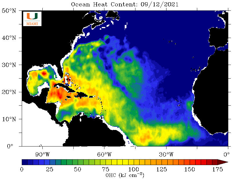
Re: ATL: NICHOLAS - Tropical Storm - Discussion
Look at that upper ocean heat content in the Western Gulf
1 likes
Re: ATL: FOURTEEN - Potential Tropical Cyclone - Discussion
aspen wrote:St Nick is here to give all the boys and girls of coastal Texas and Louisiana like a foot of rain.
The NHC is going with 55 kt for their peak. I don’t anticipate Nicholas being more than 20 kt stronger than that due to it getting 15-20 kt of shear for its entire duration in the Gulf, but it’s possible the shear could be the favorable kind like Michael because it’ll be in a similar direction as the storm’s motion.
Yeah, it is effective shear that counts. Note Nicholas is moving in the same direction as the 200mb winds late in the forecast.
2 likes
-
tolakram
- Admin

- Posts: 20186
- Age: 62
- Joined: Sun Aug 27, 2006 8:23 pm
- Location: Florence, KY (name is Mark)
Re: ATL: NICHOLAS - Tropical Storm - Discussion
000
WTNT44 KNHC 121502
TCDAT4
Tropical Storm Nicholas Discussion Number 1
NWS National Hurricane Center Miami FL AL142021
1000 AM CDT Sun Sep 12 2021
Showers and thunderstorms associated with a broad area of low
pressure over the southern Bay of Campeche have increased overnight
and very recently become better organized with a loose band of
convection around the northeastern portion of the circulation. An
Air Force Reserve reconnaissance aircraft that has been
investigating the system has found 44-kt flight-level winds and
SFMR winds that support a 35-kt initial intensity. Based on the
recent increase in organization and the 35-kt initial intensity,
advisories are being initiated on Tropical Storm Nicholas, the
fourteenth named storm of the Atlantic hurricane season.
The storm is located within an environment of moderate
south-southwesterly vertical wind shear, over warm waters, and in a
moist and unstable atmosphere. These conditions should allow gradual
strengthening over the next 24 to 48 hours. The NHC intensity
forecast follows suit and calls for gradual strengthening until
the system reaches the coast of Texas. The official wind speed
forecast is near the higher end of the guidance in best agreement
with the SHIPS statistical guidance, the HFIP corrected consensus,
and the HWRF. In this case, the intensity forecast is highly
dependent on eventual track of the system. A track to the east of
the NHC forecast could result in a lower wind shear environment
and slightly more time over water for the system to strengthen.
Conversely a track to the west of the forecast track would result
in the system interacting with land much sooner.
Since the system is still in its formative stage the initial motion
estimate is a somewhat uncertain 330/11 kt. A north-northwestward
motion around the western portion of a mid-level ridge that is
sliding east near the coast of the Carolinas, should continue to
steer Nicholas in that direction for the next 24 to 48 hours.
After that time, steering currents weaken and the cyclone is
expected to move slowly north-northeastward between a couple of
mid-level ridges located to the east and west of Nicholas. The
track guidance generally agrees with this overall scenario but
there is some cross-track spread with the UKMET along the left side
of the guidance envelope taking the storm into northeastern Mexico,
while the GFS, HWRF, and HMON are along the right side. The NHC
track is near the various consensus models and both the EC and GFS
ensemble means.
Key Messages:
1. Tropical storm conditions are expected along portions of the
northeastern coast of Mexico and the coast of south Texas
beginning on Monday. Nicholas is forecast to approach the middle
Texas coast as a strong tropical storm on Tuesday, and tropical
storm conditions are possible along portions of the middle and upper
Texas coasts late Monday night and Tuesday.
2. There is the possibility of life-threatening storm surge along
the coast of Texas from the Mouth of the Rio Grande to High Island.
Residents in these areas should follow any advice given by local
officials.
3. Periods of heavy rainfall are expected to impact portions of the
Texas and Louisiana coasts today through the middle of the week.
Significant rainfall amounts are possible, potentially resulting in
areas of flash, urban, and isolated river flooding.
FORECAST POSITIONS AND MAX WINDS
INIT 12/1500Z 20.5N 94.8W 35 KT 40 MPH
12H 13/0000Z 21.9N 95.7W 40 KT 45 MPH
24H 13/1200Z 24.1N 96.6W 45 KT 50 MPH
36H 14/0000Z 26.4N 96.9W 50 KT 60 MPH
48H 14/1200Z 28.2N 96.5W 55 KT 65 MPH
60H 15/0000Z 29.4N 95.9W 40 KT 45 MPH...INLAND
72H 15/1200Z 30.3N 95.2W 30 KT 35 MPH...INLAND
96H 16/1200Z 31.0N 94.8W 25 KT 30 MPH...INLAND
120H 17/1200Z 32.0N 94.5W 20 KT 25 MPH...POST-TROP/REMNT LOW
$$
Forecaster Brown
1 likes
M a r k
- - - - -
Join us in chat: Storm2K Chatroom Invite. Android and IOS apps also available.
The posts in this forum are NOT official forecasts and should not be used as such. Posts are NOT endorsed by any professional institution or STORM2K.org. For official information and forecasts, please refer to NHC and NWS products.
Re: ATL: NICHOLAS - Tropical Storm - Discussion
Recon found slightly lower SLPs further north, CoC might be forming better there, closer to 22N.

1 likes

Re: ATL: NICHOLAS - Tropical Storm - Discussion
Just trying to figure the recon wind map.
My sense is this may be quickly developing a feeder band with high TPW air coming in from the EPAC.
My sense is this may be quickly developing a feeder band with high TPW air coming in from the EPAC.
1 likes
Re: ATL: NICHOLAS - Tropical Storm - Discussion
First time I have heard that further east is lower shear. I think with the current conditions a stronger storm goes further east. Feedback loop?
A track to the east of
the NHC forecast could result in a lower wind shear environment
and slightly more time over water for the system to strengthen.
Conversely a track to the west of the forecast track would result
in the system interacting with land much sooner
the NHC forecast could result in a lower wind shear environment
and slightly more time over water for the system to strengthen.
Conversely a track to the west of the forecast track would result
in the system interacting with land much sooner
0 likes
Re: ATL: NICHOLAS - Tropical Storm - Discussion
Lots of convection in the western GOM but the rains along the LA coast are indirectly associated with Nicholas, is from mid level trough along with a surface trough/old front.

0 likes
Who is online
Users browsing this forum: No registered users and 24 guests