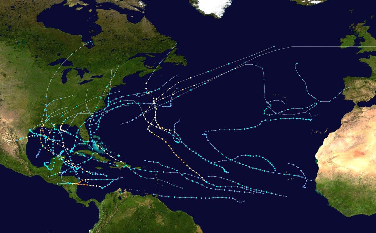
2021 Indicators: SST's / SAL / MSLP / Shear / Steering / Instability / Sat Images

This is the general tropical discussion area. Anyone can take their shot at predicting a storms path.

Moderator: S2k Moderators

Forum rules

The posts in this forum are NOT official forecasts and should not be used as such. They are just the opinion of the poster and may or may not be backed by sound meteorological data. They are NOT endorsed by any professional institution or STORM2K. For official information, please refer to products from the National Hurricane Center and National Weather Service.

Help Support Storm2K
Message
Author
SteveM
Tropical Depression
Tropical Depression
Posts: 76
Joined: Wed Jul 22, 2020 8:21 am

Re: 2021 Indicators: SST's / SAL / MSLP / Shear / Steering / Instability / Sat Images

#3261 Postby SteveM » Sun Sep 12, 2021 7:29 am

Category5Kaiju wrote:While I do not expect 2021 to do the same in any way and expect an active October (similar to 2020, though strength and quantity-wise I am not very sure how well they will mirror one another) given our direction toward a solid La Nina, was there a reason why 2017, which was also a destructive and active year headed towards a La Nina, suddenly shut down after Nate/Ophelia in October, with not much quality activity occurring afterwards?


There is no real reason to expect high quality systems from late October onwards, a Nina doesn't necessarily negate that.
3 likes   

User avatar
aspen
Category 5
Category 5
Posts: 8818
Joined: Sat Oct 12, 2019 7:10 pm
Location: Connecticut, USA

Re: 2021 Indicators: SST's / SAL / MSLP / Shear / Steering / Instability / Sat Images

#3262 Postby aspen » Sun Sep 12, 2021 7:42 am

I think there’s a high chance of another major sometime in the late season. Within the most recent active phase, only 2019 (a warm-neutral ENSO/weak Niño year) didn’t produce at least one major in the October to November timeframe; 2016 had Nicole and Otto (Matthew too even though it formed in late September), 2017 had Ophelia, 2018 had Michael, and 2020 had the parade of WCar/Gulf majors as well as Epsilon. 2017 is the only cool-neutral/weak Nina season to not have a deep western tropics major, but all three cool ENSO years (2016, 2017, and 2020) had a major in the subtropics/mid-latitudes.

Since 2021 is part of this recent active streak and is currently a cool ENSO year with a La Nina likely to develop in the next few weeks, a late season major seems rather probable. There’s no telling if it’ll be something in the Caribbean/Gulf like Matthew and Michael, or a subtropics major like Nicole, Ophelia, or Epsilon.
0 likes   
Irene '11 Sandy '12 Hermine '16 5/15/2018 Derecho Fay '20 Isaias '20 Elsa '21 Henri '21 Ida '21

I am only a meteorology enthusiast who knows a decent amount about tropical cyclones. Look to the professional mets, the NHC, or your local weather office for the best information.

User avatar
Category5Kaiju
Category 5
Category 5
Posts: 4097
Joined: Thu Dec 24, 2020 12:45 pm
Location: Seattle

Re: 2021 Indicators: SST's / SAL / MSLP / Shear / Steering / Instability / Sat Images

#3263 Postby Category5Kaiju » Sun Sep 12, 2021 7:53 am

aspen wrote:I think there’s a high chance of another major sometime in the late season. Within the most recent active phase, only 2019 (a warm-neutral ENSO/weak Niño year) didn’t produce at least one major in the October to November timeframe; 2016 had Nicole and Otto (Matthew too even though it formed in late September), 2017 had Ophelia, 2018 had Michael, and 2020 had the parade of WCar/Gulf majors as well as Epsilon. 2017 is the only cool-neutral/weak Nina season to not have a deep western tropics major, but all three cool ENSO years (2016, 2017, and 2020) had a major in the subtropics/mid-latitudes.

Since 2021 is part of this recent active streak and is currently a cool ENSO year with a La Nina likely to develop in the next few weeks, a late season major seems rather probable. There’s no telling if it’ll be something in the Caribbean/Gulf like Matthew and Michael, or a subtropics major like Nicole, Ophelia, or Epsilon.


And it's not unusual for seasons to follow the principle of "there's always a bigger fish." In other words, during August or early September we see a powerful, nasty storm and think that that storm is the season's definer and strongest storm, when in reality it is a late September, October, or even November storm that ends up even more powerful than what we thought would be the season's definer and claims that title instead. Examples of this include 1932, 1998 (Georges to Mitch), 2001 (Iris to Michelle), 2005 (Katrina to Rita and then to Wilma), 2018 (Florence to Michael), and most recently last year (Laura to Eta and then to Iota). There's no idea to know if Ida is going to lose her status as strongest storm of the season, only to be replaced by a late September or October/November monster, but given that it's a La Nina year, I wouldn't say it's a not-gonna-happen case.
2 likes   
Unless explicitly stated, all info in my posts is based on my own opinions and observations. Tropical storms and hurricanes can be extremely dangerous. Do not think you can beat Mother Nature. Refer to an accredited weather research agency or meteorologist if you need to make serious decisions regarding an approaching storm.

tolakram
Admin
Admin
Posts: 20009
Age: 62
Joined: Sun Aug 27, 2006 8:23 pm
Location: Florence, KY (name is Mark)

Re: 2021 Indicators: SST's / SAL / MSLP / Shear / Steering / Instability / Sat Images

#3264 Postby tolakram » Sun Sep 12, 2021 11:07 am

If 2021 had 2005 upper air patterns then Elsa and Ida would have been long tracking majors. So far 2021 has struggled with good conditions, even though it shouldn't have. 2017 is a good example of a season that should not have shut down but did. 2021 might be an example of one that really gets going late. Who knows, we certainly don't. If the wave emerging off of Africa ends up being a late long tracking CV system and does better than Larry did then things might get interesting.

I know some of you don't like ACE, we have a thread for that and it's a very interesting discussion. :)
4 likes   
M a r k
- - - - -
Join us in chat: Storm2K Chatroom Invite. Android and IOS apps also available.

The posts in this forum are NOT official forecasts and should not be used as such. Posts are NOT endorsed by any professional institution or STORM2K.org. For official information and forecasts, please refer to NHC and NWS products.

User avatar
Steve
S2K Supporter
S2K Supporter
Posts: 9621
Joined: Sat Apr 05, 2003 11:41 pm
Location: Not a state-caster

Re: 2021 Indicators: SST's / SAL / MSLP / Shear / Steering / Instability / Sat Images

#3265 Postby Steve » Sun Sep 12, 2021 11:21 am

Extended vacation in Phase 3 of the MJO plus favorable upward motion moving into the SW Basin = development. Nicholas first.
http://www.atmos.albany.edu/student/ven ... lyses.html
0 likes   

AlphaToOmega
Category 5
Category 5
Posts: 1448
Joined: Sat Jun 26, 2021 10:51 am
Location: Somewhere in Massachusetts

Re: 2021 Indicators: SST's / SAL / MSLP / Shear / Steering / Instability / Sat Images

#3266 Postby AlphaToOmega » Sun Sep 12, 2021 2:41 pm

Three storms already this September
The suppressive CCKW, unfavorable MJO, and SAL did not seem to be enough to fight climatology
3 likes   

AlphaToOmega
Category 5
Category 5
Posts: 1448
Joined: Sat Jun 26, 2021 10:51 am
Location: Somewhere in Massachusetts

Re: 2021 Indicators: SST's / SAL / MSLP / Shear / Steering / Instability / Sat Images

#3267 Postby AlphaToOmega » Sun Sep 12, 2021 3:50 pm

weeniepatrol wrote:Folks, this was well forecast :lol: just like every other year on record there is intraseasonal activity and right now clearly the Pacific is favored with genesis in the epac and wpac recently. As always happens with no el Nino favorability will propagate eastward. Atlantic is taking a power nap and I can't wait for the late Sept/early Oct burst to silence detractors for good until May 2022 :lol: :lol: :lol: like clockwork every year

https://i.imgur.com/vgt0S2v.png


So...about that quiet period
Two storms formed between September 8 and today
0 likes   

User avatar
Category5Kaiju
Category 5
Category 5
Posts: 4097
Joined: Thu Dec 24, 2020 12:45 pm
Location: Seattle

Re: 2021 Indicators: SST's / SAL / MSLP / Shear / Steering / Instability / Sat Images

#3268 Postby Category5Kaiju » Sun Sep 12, 2021 3:56 pm

We have 7 more names after Nicholas, and with the Bahamas AOI and the MDR AOI being very real contenders for names, being by Rose by the end of September at least is not a bad guess imho. The last seasons to feature an R storm in September...oh yeah, 2005 and 2020.
2 likes   
Unless explicitly stated, all info in my posts is based on my own opinions and observations. Tropical storms and hurricanes can be extremely dangerous. Do not think you can beat Mother Nature. Refer to an accredited weather research agency or meteorologist if you need to make serious decisions regarding an approaching storm.

AlphaToOmega
Category 5
Category 5
Posts: 1448
Joined: Sat Jun 26, 2021 10:51 am
Location: Somewhere in Massachusetts

Re: 2021 Indicators: SST's / SAL / MSLP / Shear / Steering / Instability / Sat Images

#3269 Postby AlphaToOmega » Sun Sep 12, 2021 4:11 pm

Looking at every hurricane season directly preceding a weak or moderate La Nina since 2000, we see a pattern:
-2020: Teddy, Delta, Epsilon, Zeta, Eta, and Iota (6 major hurricanes after September 12)
-2017: Lee, Maria and Ophelia (3 major hurricanes after September 12)
-2016: Matthew, Nicole, and Otto (3 major hurricanes after September 12)
-2011: Ophelia and Rina (2 major hurricanes after September 12)
-2008: Omar and Paloma (2 major hurricanes after September 12)
-2005: Rita, Wilma, and Beta (3 major hurricanes after September 12)
-2001: Iris and Michelle (2 major hurricanes after September 12)
-2000: Isaac and Keith (2 major hurricanes after September 12)

Each of these weak or moderate La Nina seasons features multiple major hurricanes after September 12. With this amount of evidence, I believe we will see at least a total of 5 major hurricanes before the season is over.
0 likes   

User avatar
Hammy
Category 5
Category 5
Posts: 5849
Age: 41
Joined: Fri May 25, 2012 5:25 pm
Contact:

Re: 2021 Indicators: SST's / SAL / MSLP / Shear / Steering / Instability / Sat Images

#3270 Postby Hammy » Mon Sep 13, 2021 3:05 pm

AlphaToOmega wrote:Looking at every hurricane season directly preceding a weak or moderate La Nina since 2000, we see a pattern:
-2020: Teddy, Delta, Epsilon, Zeta, Eta, and Iota (6 major hurricanes after September 12)
-2017: Lee, Maria and Ophelia (3 major hurricanes after September 12)
-2016: Matthew, Nicole, and Otto (3 major hurricanes after September 12)
-2011: Ophelia and Rina (2 major hurricanes after September 12)
-2008: Omar and Paloma (2 major hurricanes after September 12)
-2005: Rita, Wilma, and Beta (3 major hurricanes after September 12)
-2001: Iris and Michelle (2 major hurricanes after September 12)
-2000: Isaac and Keith (2 major hurricanes after September 12)

Each of these weak or moderate La Nina seasons features multiple major hurricanes after September 12. With this amount of evidence, I believe we will see at least a total of 5 major hurricanes before the season is over.


I would personally use September 20, rather than today's date, as a metric--storms like Lee, Maria, or Teddy had either already formed or were on the verge of formation, and had high model support for becoming strong hurricanes--the present model trend is towards there being no hurricanes (let alone majors) during the forecast period.

We're highly unlikely to have any majors (or any hurricanes at all) in the next week given the open Atlantic as everything (Larry included) has underperformed over the open Atlantic.
3 likes   
The above post is not official and should not be used as such. It is the opinion of the poster and may or may not be backed by sound meteorological data. It is not endorsed by any professional institution or storm2k.org. For official information, please refer to the NHC and NWS products.

AlphaToOmega
Category 5
Category 5
Posts: 1448
Joined: Sat Jun 26, 2021 10:51 am
Location: Somewhere in Massachusetts

Re: 2021 Indicators: SST's / SAL / MSLP / Shear / Steering / Instability / Sat Images

#3271 Postby AlphaToOmega » Mon Sep 13, 2021 3:17 pm

Hammy wrote:
AlphaToOmega wrote:Looking at every hurricane season directly preceding a weak or moderate La Nina since 2000, we see a pattern:
-2020: Teddy, Delta, Epsilon, Zeta, Eta, and Iota (6 major hurricanes after September 12)
-2017: Lee, Maria and Ophelia (3 major hurricanes after September 12)
-2016: Matthew, Nicole, and Otto (3 major hurricanes after September 12)
-2011: Ophelia and Rina (2 major hurricanes after September 12)
-2008: Omar and Paloma (2 major hurricanes after September 12)
-2005: Rita, Wilma, and Beta (3 major hurricanes after September 12)
-2001: Iris and Michelle (2 major hurricanes after September 12)
-2000: Isaac and Keith (2 major hurricanes after September 12)

Each of these weak or moderate La Nina seasons features multiple major hurricanes after September 12. With this amount of evidence, I believe we will see at least a total of 5 major hurricanes before the season is over.


I would personally use September 20, rather than today's date, as a metric--storms like Lee, Maria, or Teddy had either already formed or were on the verge of formation, and had high model support for becoming strong hurricanes--the present model trend is towards there being no hurricanes (let alone majors) during the forecast period.

We're highly unlikely to have any majors (or any hurricanes at all) in the next week given the open Atlantic as everything (Larry included) has underperformed over the open Atlantic.


We might not see a major hurricane in the next week, but I still expect multiple major hurricanes between now and the end of the season based on what history tells us.
2 likes   

User avatar
aspen
Category 5
Category 5
Posts: 8818
Joined: Sat Oct 12, 2019 7:10 pm
Location: Connecticut, USA

Re: 2021 Indicators: SST's / SAL / MSLP / Shear / Steering / Instability / Sat Images

#3272 Postby aspen » Mon Sep 13, 2021 3:22 pm

Hammy wrote:We're highly unlikely to have any majors (or any hurricanes at all) in the next week given the open Atlantic as everything (Larry included) has underperformed over the open Atlantic.

Larry was mostly limited by complex internal processes rather than environmental factors. While it could’ve peaked as a 120-125 kt Cat 4, most models showed a peak in the mid 960s to mid 950s range (HWRF included), and that’s exactly what we got.

Julian and Kate, on the other hand, were definitely victims of sub-optimal conditions in the central Atlantic. The models were very persistent on Julian becoming a baroclinic-forced Cat 2/3 in the subtropics, but it took forever to form and quickly became post-Tropical when it did finally form. Kate was blasted by shear and dry air, although it was kind of an over-achiever seeing how no model developed it before hand.
3 likes   
Irene '11 Sandy '12 Hermine '16 5/15/2018 Derecho Fay '20 Isaias '20 Elsa '21 Henri '21 Ida '21

I am only a meteorology enthusiast who knows a decent amount about tropical cyclones. Look to the professional mets, the NHC, or your local weather office for the best information.

User avatar
Category5Kaiju
Category 5
Category 5
Posts: 4097
Joined: Thu Dec 24, 2020 12:45 pm
Location: Seattle

Re: 2021 Indicators: SST's / SAL / MSLP / Shear / Steering / Instability / Sat Images

#3273 Postby Category5Kaiju » Mon Sep 13, 2021 3:26 pm

Hammy wrote:
AlphaToOmega wrote:Looking at every hurricane season directly preceding a weak or moderate La Nina since 2000, we see a pattern:
-2020: Teddy, Delta, Epsilon, Zeta, Eta, and Iota (6 major hurricanes after September 12)
-2017: Lee, Maria and Ophelia (3 major hurricanes after September 12)
-2016: Matthew, Nicole, and Otto (3 major hurricanes after September 12)
-2011: Ophelia and Rina (2 major hurricanes after September 12)
-2008: Omar and Paloma (2 major hurricanes after September 12)
-2005: Rita, Wilma, and Beta (3 major hurricanes after September 12)
-2001: Iris and Michelle (2 major hurricanes after September 12)
-2000: Isaac and Keith (2 major hurricanes after September 12)

Each of these weak or moderate La Nina seasons features multiple major hurricanes after September 12. With this amount of evidence, I believe we will see at least a total of 5 major hurricanes before the season is over.


I would personally use September 20, rather than today's date, as a metric--storms like Lee, Maria, or Teddy had either already formed or were on the verge of formation, and had high model support for becoming strong hurricanes--the present model trend is towards there being no hurricanes (let alone majors) during the forecast period.

We're highly unlikely to have any majors (or any hurricanes at all) in the next week given the open Atlantic as everything (Larry included) has underperformed over the open Atlantic.


We'll see what happens, although I cannot imagine how for the rest of this season the Atlantic would underperform. I mean, we're entering La Nina, and the WPAC and EPAC have definitely been underperforming overall as well. For all three of these basins to underperform would be pretty surprising, and "surprising" is an understatement.
1 likes   
Unless explicitly stated, all info in my posts is based on my own opinions and observations. Tropical storms and hurricanes can be extremely dangerous. Do not think you can beat Mother Nature. Refer to an accredited weather research agency or meteorologist if you need to make serious decisions regarding an approaching storm.

User avatar
Hammy
Category 5
Category 5
Posts: 5849
Age: 41
Joined: Fri May 25, 2012 5:25 pm
Contact:

Re: 2021 Indicators: SST's / SAL / MSLP / Shear / Steering / Instability / Sat Images

#3274 Postby Hammy » Mon Sep 13, 2021 3:52 pm

Category5Kaiju wrote:
Hammy wrote:
AlphaToOmega wrote:Looking at every hurricane season directly preceding a weak or moderate La Nina since 2000, we see a pattern:
-2020: Teddy, Delta, Epsilon, Zeta, Eta, and Iota (6 major hurricanes after September 12)
-2017: Lee, Maria and Ophelia (3 major hurricanes after September 12)
-2016: Matthew, Nicole, and Otto (3 major hurricanes after September 12)
-2011: Ophelia and Rina (2 major hurricanes after September 12)
-2008: Omar and Paloma (2 major hurricanes after September 12)
-2005: Rita, Wilma, and Beta (3 major hurricanes after September 12)
-2001: Iris and Michelle (2 major hurricanes after September 12)
-2000: Isaac and Keith (2 major hurricanes after September 12)

Each of these weak or moderate La Nina seasons features multiple major hurricanes after September 12. With this amount of evidence, I believe we will see at least a total of 5 major hurricanes before the season is over.


I would personally use September 20, rather than today's date, as a metric--storms like Lee, Maria, or Teddy had either already formed or were on the verge of formation, and had high model support for becoming strong hurricanes--the present model trend is towards there being no hurricanes (let alone majors) during the forecast period.

We're highly unlikely to have any majors (or any hurricanes at all) in the next week given the open Atlantic as everything (Larry included) has underperformed over the open Atlantic.


We'll see what happens, although I cannot imagine how for the rest of this season the Atlantic would underperform. I mean, we're entering La Nina, and the WPAC and EPAC have definitely been underperforming overall as well. For all three of these basins to underperform would be pretty surprising, and "surprising" is an understatement.


Very true, but always good to give a window when calculating what has formed after a certain point, since some of those were only a few days out from forming, something we aren't going to repeat this year.

1990 is an interesting comparison season, and the middle portion of the season went somewhat similarly--we had an active August, with 6/2/1, including a hurricane into Mexico (compared to this year's 6/3/2) followed by a generally subpar September--Isidore formed on Sep 3, and while it lasted two weeks (peaking at 100 mph), nothing else actually formed for over two weeks--TD11 on September Sep 18, and then Josephine on Sep 21, which similar to so many waves this season, turned NW, went out to sea and weakened to a depression within days. October on the other hand was quite busy--4/3/0 for the month, in addition to Josephine eventually reaching hurricane intensity.

We're going to reach mid-month with 3/1/1 for September, which is one weak and one moderate tropical storm past what 1990 produced, and it sees we're going to see a spate of weak storms over the next week or so before things pick up again as far as stronger systems go.
0 likes   
The above post is not official and should not be used as such. It is the opinion of the poster and may or may not be backed by sound meteorological data. It is not endorsed by any professional institution or storm2k.org. For official information, please refer to the NHC and NWS products.

tolakram
Admin
Admin
Posts: 20009
Age: 62
Joined: Sun Aug 27, 2006 8:23 pm
Location: Florence, KY (name is Mark)

Re: 2021 Indicators: SST's / SAL / MSLP / Shear / Steering / Instability / Sat Images

#3275 Postby tolakram » Mon Sep 13, 2021 4:43 pm

aspen wrote:
Hammy wrote:We're highly unlikely to have any majors (or any hurricanes at all) in the next week given the open Atlantic as everything (Larry included) has underperformed over the open Atlantic.

Larry was mostly limited by complex internal processes rather than environmental factors. While it could’ve peaked as a 120-125 kt Cat 4, most models showed a peak in the mid 960s to mid 950s range (HWRF included), and that’s exactly what we got.

Julian and Kate, on the other hand, were definitely victims of sub-optimal conditions in the central Atlantic. The models were very persistent on Julian becoming a baroclinic-forced Cat 2/3 in the subtropics, but it took forever to form and quickly became post-Tropical when it did finally form. Kate was blasted by shear and dry air, although it was kind of an over-achiever seeing how no model developed it before hand.


I don;t believe this. Larry was limited by environmental conditions we didn't or can't readily measure. Mid-level shear, mid level dry air, or something else. IMO.
1 likes   
M a r k
- - - - -
Join us in chat: Storm2K Chatroom Invite. Android and IOS apps also available.

The posts in this forum are NOT official forecasts and should not be used as such. Posts are NOT endorsed by any professional institution or STORM2K.org. For official information and forecasts, please refer to NHC and NWS products.

User avatar
aspen
Category 5
Category 5
Posts: 8818
Joined: Sat Oct 12, 2019 7:10 pm
Location: Connecticut, USA

Re: 2021 Indicators: SST's / SAL / MSLP / Shear / Steering / Instability / Sat Images

#3276 Postby aspen » Mon Sep 13, 2021 5:01 pm

tolakram wrote:
aspen wrote:
Hammy wrote:We're highly unlikely to have any majors (or any hurricanes at all) in the next week given the open Atlantic as everything (Larry included) has underperformed over the open Atlantic.

Larry was mostly limited by complex internal processes rather than environmental factors. While it could’ve peaked as a 120-125 kt Cat 4, most models showed a peak in the mid 960s to mid 950s range (HWRF included), and that’s exactly what we got.

Julian and Kate, on the other hand, were definitely victims of sub-optimal conditions in the central Atlantic. The models were very persistent on Julian becoming a baroclinic-forced Cat 2/3 in the subtropics, but it took forever to form and quickly became post-Tropical when it did finally form. Kate was blasted by shear and dry air, although it was kind of an over-achiever seeing how no model developed it before hand.


I don;t believe this. Larry was limited by environmental conditions we didn't or can't readily measure. Mid-level shear, mid level dry air, or something else. IMO.

I recall someone on Larry’s thread suggesting that the level of dry air was high enough for an annular-like hurricane, but not high enough to kill the outer bands like a true annular storm, explaining why Larry just kept on producing EWRC after EWRC despite eyewalls getting up to 50-100+ miles across.
0 likes   
Irene '11 Sandy '12 Hermine '16 5/15/2018 Derecho Fay '20 Isaias '20 Elsa '21 Henri '21 Ida '21

I am only a meteorology enthusiast who knows a decent amount about tropical cyclones. Look to the professional mets, the NHC, or your local weather office for the best information.

User avatar
Steve
S2K Supporter
S2K Supporter
Posts: 9621
Joined: Sat Apr 05, 2003 11:41 pm
Location: Not a state-caster

Re: 2021 Indicators: SST's / SAL / MSLP / Shear / Steering / Instability / Sat Images

#3277 Postby Steve » Mon Sep 13, 2021 7:13 pm

AlphaToOmega wrote:Three storms already this September
The suppressive CCKW, unfavorable MJO, and SAL did not seem to be enough to fight climatology


MJO really hasn’t been that unfavorable. After the last run through 2 that brought us Ida, J and K, models had it moving up toward 5/6. But it went back to the circle only to re-emerge into 2 then 3 where it is now and may well be for a week. 3 is a very + Phase regardless of suppressive kelvin waves and otherwise inhibiting factors and background situations. Models still want to MJO toward 5 and 6, but they bombed on it last time. So idk.
https://www.cpc.ncep.noaa.gov/products/ ... r_wh.shtml

Also positive VPs are in the Caribbean, so maybe something pops east of 80 in the next couple days?
http://www.atmos.albany.edu/student/ven ... lyses.html
1 likes   

User avatar
toad strangler
S2K Supporter
S2K Supporter
Posts: 4543
Joined: Sun Jul 28, 2013 3:09 pm
Location: Earth
Contact:

Re: 2021 Indicators: SST's / SAL / MSLP / Shear / Steering / Instability / Sat Images

#3278 Postby toad strangler » Mon Sep 13, 2021 8:03 pm

He's controversial for sure, but love or hate, he's always been a pro at pattern recognition. We shall see!

 http://twitter.com/BigJoeBastardi/status/1437579957832716297


1 likes   

tolakram
Admin
Admin
Posts: 20009
Age: 62
Joined: Sun Aug 27, 2006 8:23 pm
Location: Florence, KY (name is Mark)

Re: 2021 Indicators: SST's / SAL / MSLP / Shear / Steering / Instability / Sat Images

#3279 Postby tolakram » Mon Sep 13, 2021 8:15 pm

toad strangler wrote:He's controversial for sure, but love or hate, he's always been a pro at pattern recognition. We shall see!

http://twitter.com/BigJoeBastardi/status/1437579957832716297?s=20


I agree. He did a video 4 hours ago that called Nick almost to a tee, he even underestimated pressure. I just wish he separate his meteorological skills with all the other crap he posts.
2 likes   
M a r k
- - - - -
Join us in chat: Storm2K Chatroom Invite. Android and IOS apps also available.

The posts in this forum are NOT official forecasts and should not be used as such. Posts are NOT endorsed by any professional institution or STORM2K.org. For official information and forecasts, please refer to NHC and NWS products.

User avatar
gatorcane
S2K Supporter
S2K Supporter
Posts: 23691
Age: 47
Joined: Sun Mar 13, 2005 3:54 pm
Location: Boca Raton, FL

Re: 2021 Indicators: SST's / SAL / MSLP / Shear / Steering / Instability / Sat Images

#3280 Postby gatorcane » Mon Sep 13, 2021 8:38 pm

Interesting that 2021 so far has the large area near the Bahamas and in the SW Atlantic void of activity but comparing the two maps, overall looks like similar tracks so far. JB has a point about the Western Caribbean come late season. Thinking we get something big originating from there again this year possibly in October again. Last year was CAT 4 Delta which eventually made landfall in LA. October usually favors eastern Gulf and particularly Florida especially mid to late month.

2020:
Image

2021:
Image
1 likes   


Return to “Talkin' Tropics”

Who is online

Users browsing this forum: Google Adsense [Bot], StormWeather, Stratton23, Ulf, WaveBreaking and 40 guests