https://ftp.nhc.noaa.gov/atcf/btk/
ATL: ODETTE - Post-Tropical - Discussion
Moderator: S2k Moderators
ATL: ODETTE - Post-Tropical - Discussion
AL, 96, 2021091412, , BEST, 0, 235N, 715W, 20, 1014, DB, 34, NEQ, 0, 0, 0, 0, 1015, 95, 90, 0, 0, L, 0, , 0, 0, INVEST, S, 0, , 0, 0, 0, 0, genesis-num, 033, SPAWNINVEST, al762021 to al962021,
https://ftp.nhc.noaa.gov/atcf/btk/
0 likes
Re: ATL: INVEST 96L - Discussion
The track and timing of 96L is quite similar to Humberto ‘19. It likely won’t get nearly as strong, though. The eastward trends are a welcome sign.
0 likes
Irene '11 Sandy '12 Hermine '16 5/15/2018 Derecho Fay '20 Isaias '20 Elsa '21 Henri '21 Ida '21
I am only a meteorology enthusiast who knows a decent amount about tropical cyclones. Look to the professional mets, the NHC, or your local weather office for the best information.
I am only a meteorology enthusiast who knows a decent amount about tropical cyclones. Look to the professional mets, the NHC, or your local weather office for the best information.
-
Sciencerocks
- Category 5

- Posts: 10186
- Age: 40
- Joined: Thu Jul 06, 2017 1:51 am
-
OuterBanker
- S2K Supporter

- Posts: 1761
- Joined: Wed Feb 26, 2003 10:53 am
- Location: Nags Head, NC
- Contact:
Re: ATL: INVEST 96L - Discussion
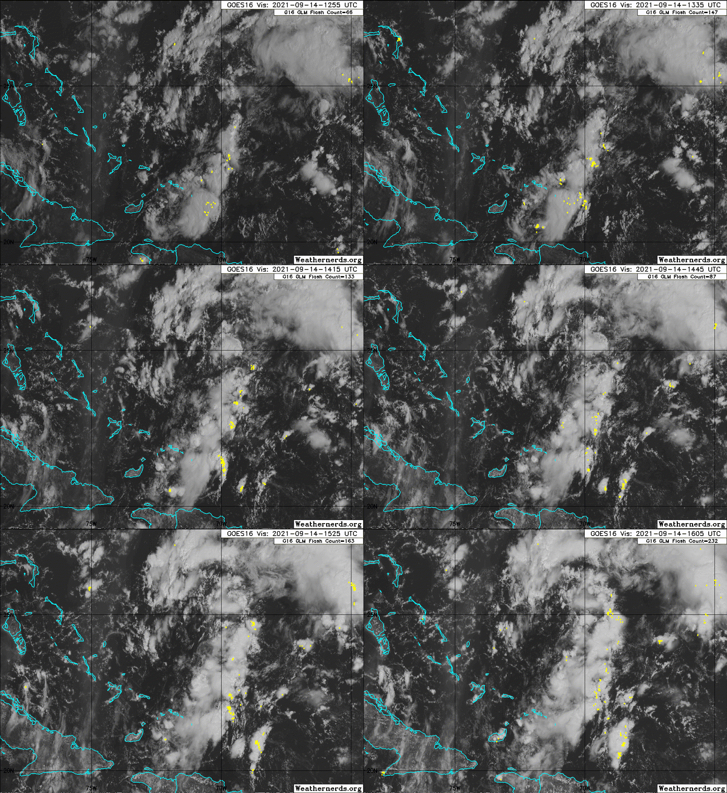
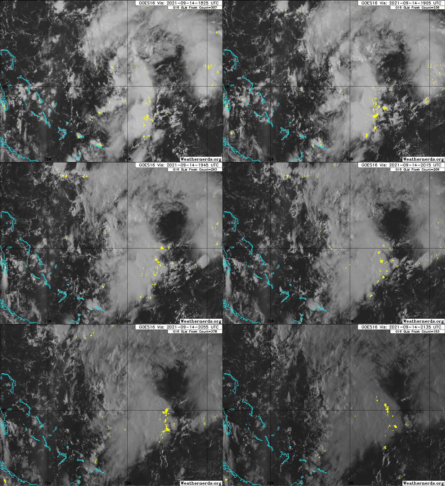
Although there seems to be no dominant llc it does seem that the banding from the nw and the banding from the turks and Caicos are trying to consolidate. The nw banding looks like the tail end of the trough split. While the turks and Caicos banding looks to dominate. Of course that could be very temporary.
3 likes
-
Sciencerocks
- Category 5

- Posts: 10186
- Age: 40
- Joined: Thu Jul 06, 2017 1:51 am
- ScottNAtlanta
- Category 5

- Posts: 2535
- Joined: Sat May 25, 2013 3:11 pm
- Location: Atlanta, GA
Re: ATL: INVEST 96L - Discussion
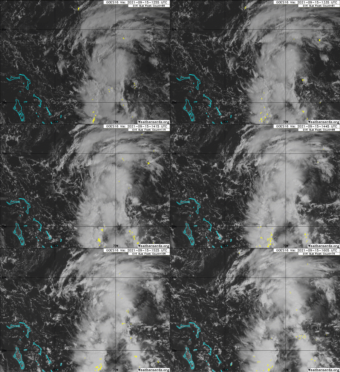
That sure looks to me on the last frames that an LLC is forming. It is no longer entangled with the ULL and has an anticyclone forming above it. This looks way better than it did earlier today.
0 likes
The posts in this forum are NOT official forecast and should not be used as such. They are just the opinion of the poster and may or may not be backed by sound meteorological data. They are NOT endorsed by any professional institution or storm2k.org. For official information, please refer to the NHC and NWS products.
- Hurricaneman
- Category 5

- Posts: 7404
- Age: 45
- Joined: Tue Aug 31, 2004 3:24 pm
- Location: central florida
Re: ATL: INVEST 96L - Discussion
ScottNAtlanta wrote:That sure looks to me on the last frames that an LLC is forming. It is no longer entangled with the ULL and has an anticyclone forming above it. This looks way better than it did earlier today.
I feel like it is finally starting cyclogenesis and here’s what I think on track, weaker means more likely stall while a stronger system will get out of the way of 95L so this system may give TS conditions to the Carolinas but it’s strength of this could be a cliffhanger in the saga of 95L
0 likes
-
AlphaToOmega
- Category 5

- Posts: 1448
- Joined: Sat Jun 26, 2021 10:51 am
- Location: Somewhere in Massachusetts
Re: ATL: INVEST 96L - Discussion
A trough of low pressure located a couple of hundred miles
north-northeast of the southeastern Bahamas is producing a large
area of disorganized showers and thunderstorms. Environmental
conditions are forecast to be marginally conducive for gradual
development during the next few days, and a tropical depression is
likely to form while the system moves north-northwestward to
northward across the western Atlantic.
* Formation chance through 48 hours...medium...50 percent.
* Formation chance through 5 days...high...70 percent.
0 likes
- ElectricStorm
- Category 5

- Posts: 5148
- Age: 25
- Joined: Tue Aug 13, 2019 11:23 pm
- Location: Norman, OK
Re: ATL: INVEST 96L - Discussion
Hurricaneman wrote:ScottNAtlanta wrote:That sure looks to me on the last frames that an LLC is forming. It is no longer entangled with the ULL and has an anticyclone forming above it. This looks way better than it did earlier today.
I feel like it is finally starting cyclogenesis and here’s what I think on track, weaker means more likely stall while a stronger system will get out of the way of 95L so this system may give TS conditions to the Carolinas but it’s strength of this could be a cliffhanger in the saga of 95L
Agreed. Hopefully it stays away from the coast and puts a lid on 95L but anything is possible at this point.
0 likes
B.S Meteorology, University of Oklahoma '25
Please refer to the NHC, NWS, or SPC for official information.
Please refer to the NHC, NWS, or SPC for official information.
Re: ATL: INVEST 96L - Discussion
https://twitter.com/BigJoeBastardi/status/1437887445224280065
I know Bastardi is pretty controversial, but you can't deny that he knows his stuff.
I know Bastardi is pretty controversial, but you can't deny that he knows his stuff.
0 likes
- ScottNAtlanta
- Category 5

- Posts: 2535
- Joined: Sat May 25, 2013 3:11 pm
- Location: Atlanta, GA
Re: ATL: INVEST 96L - Discussion
He nailed Nicholas intensifying at least 12 hrs in advance and nailed exactly why...his ranting and unmatched ability to go off on some unrelated tangent is unmatched (and annoying)
1 likes
The posts in this forum are NOT official forecast and should not be used as such. They are just the opinion of the poster and may or may not be backed by sound meteorological data. They are NOT endorsed by any professional institution or storm2k.org. For official information, please refer to the NHC and NWS products.
- Category5Kaiju
- Category 5

- Posts: 4338
- Joined: Thu Dec 24, 2020 12:45 pm
- Location: Seattle during the summer, Phoenix during the winter
Re: ATL: INVEST 96L - Discussion
If 96L manages to become Odette, then I'll be very satisfied. Don't ask me why, I just feel like 96L's destiny is just that for some reason 
0 likes
Unless explicitly stated, all information in my posts is based on my own opinions and observations. Tropical storms and hurricanes can be extremely dangerous. Refer to an accredited weather research agency or meteorologist if you need to make serious decisions regarding an approaching storm.
-
OuterBanker
- S2K Supporter

- Posts: 1761
- Joined: Wed Feb 26, 2003 10:53 am
- Location: Nags Head, NC
- Contact:
Re: ATL: INVEST 96L - Discussion
Still right much of a mess. 95l looks much better. But I'm wondering if this will become Odette because of proximity to us mainland.
0 likes
-
Sciencerocks
- Category 5

- Posts: 10186
- Age: 40
- Joined: Thu Jul 06, 2017 1:51 am
- ScottNAtlanta
- Category 5

- Posts: 2535
- Joined: Sat May 25, 2013 3:11 pm
- Location: Atlanta, GA
Re: ATL: INVEST 96L - Discussion
Looks like the LLC is racing out ahead of the convection
0 likes
The posts in this forum are NOT official forecast and should not be used as such. They are just the opinion of the poster and may or may not be backed by sound meteorological data. They are NOT endorsed by any professional institution or storm2k.org. For official information, please refer to the NHC and NWS products.
- ElectricStorm
- Category 5

- Posts: 5148
- Age: 25
- Joined: Tue Aug 13, 2019 11:23 pm
- Location: Norman, OK
Re: ATL: INVEST 96L - Discussion
I'm not convinced this develops yet. Hardly any of the models develop it and the ones that do are extremely weak (12z GFS doesn't count). Could be an outside chance at a weak TD but I think the probs of development are less than the current 70% and I wouldn't be surprised to see them go down soon.
Also hasn't really gotten any better organized since yesterday
Also hasn't really gotten any better organized since yesterday
1 likes
B.S Meteorology, University of Oklahoma '25
Please refer to the NHC, NWS, or SPC for official information.
Please refer to the NHC, NWS, or SPC for official information.
Re: ATL: INVEST 96L - Discussion
Weather Dude wrote:I'm not convinced this develops yet. Hardly any of the models develop it and the ones that do are extremely weak (12z GFS doesn't count). Could be an outside chance at a weak TD but I think the probs of development are less than the current 70% and I wouldn't be surprised to see them go down soon.
Also hasn't really gotten any better organized since yesterday
HWRF/HMON develop it, and every global model has a low becoming very well-defined. Only question will be convective organization as it will be displaced during the formative stage (i.e. now). Best chance at strengthening is as it starts to transition. Modeling has a slightly sheared CDO around that time.
2 likes
Kendall -> SLO -> PBC
Memorable Storms: Katrina (for its Florida landfall...) Wilma Matthew Irma
Memorable Storms: Katrina (for its Florida landfall...) Wilma Matthew Irma
- ElectricStorm
- Category 5

- Posts: 5148
- Age: 25
- Joined: Tue Aug 13, 2019 11:23 pm
- Location: Norman, OK
Re: ATL: INVEST 96L - Discussion
Ubuntwo wrote:Weather Dude wrote:I'm not convinced this develops yet. Hardly any of the models develop it and the ones that do are extremely weak (12z GFS doesn't count). Could be an outside chance at a weak TD but I think the probs of development are less than the current 70% and I wouldn't be surprised to see them go down soon.
Also hasn't really gotten any better organized since yesterday
HWRF/HMON develop it, and every global model has a low becoming very well-defined. Only question will be convective organization as it will be displaced during the formative stage (i.e. now). Best chance at strengthening is as it starts to transition. Modeling has a slightly sheared CDO around that time.
Yeah we'll see. If it moves slower it may be able to do something before it becomes ET. I could very well be wrong but I'm not too confident this ends up doing anything
0 likes
B.S Meteorology, University of Oklahoma '25
Please refer to the NHC, NWS, or SPC for official information.
Please refer to the NHC, NWS, or SPC for official information.
-
Sciencerocks
- Category 5

- Posts: 10186
- Age: 40
- Joined: Thu Jul 06, 2017 1:51 am
Re: ATL: INVEST 96L - Discussion
Satellite images indicate that a low pressure system located a few
hundred miles northeast of the central Bahamas is gradually becoming
better defined. However, the associated showers and thunderstorms
are still disorganized. Environmental conditions are expected to
become more conducive for development, and a tropical depression is
likely to form during the next day or two while the system moves
north-northwestward to northward off the southeast U.S. coast.
Regardless of development, this system could bring high surf to
portions of the southeast and mid-Atlantic U.S. coasts later this
week. The Air Force Hurricane Hunters are currently enroute to
investigate the disturbance.
* Formation chance through 48 hours...high...70 percent.
* Formation chance through 5 days...high...70 percent.
0 likes
- AJC3
- Admin

- Posts: 4156
- Age: 62
- Joined: Tue Aug 31, 2004 7:04 pm
- Location: Ballston Spa, New York
- Contact:
Re: ATL: INVEST 96L - Discussion
ScottNAtlanta wrote:Looks like the LLC is racing out ahead of the convection
Yep. In fact, I see two vort centers moving westward in tandem on the NW flank of this trough, and possibly a third to the SE along the trough axis. This needs to do a fair bit of consolidating before it gets classified as a TC.
0 likes
Who is online
Users browsing this forum: No registered users and 27 guests


