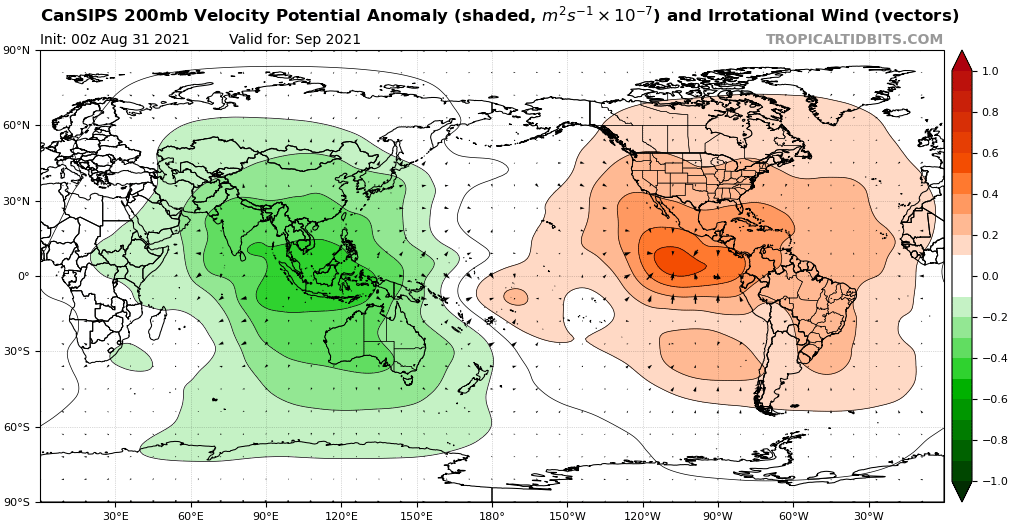
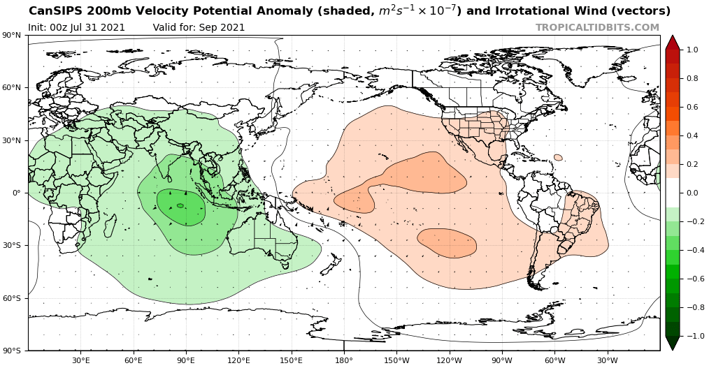
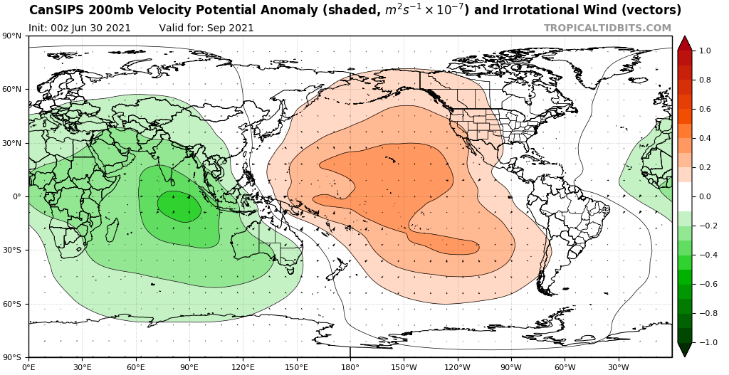
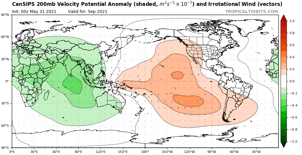
We saw this months ago. Run after run, the CanSIPS shows -VP over Africa and the Indian Ocean, leading to an active hurricane season.
Moderator: S2k Moderators


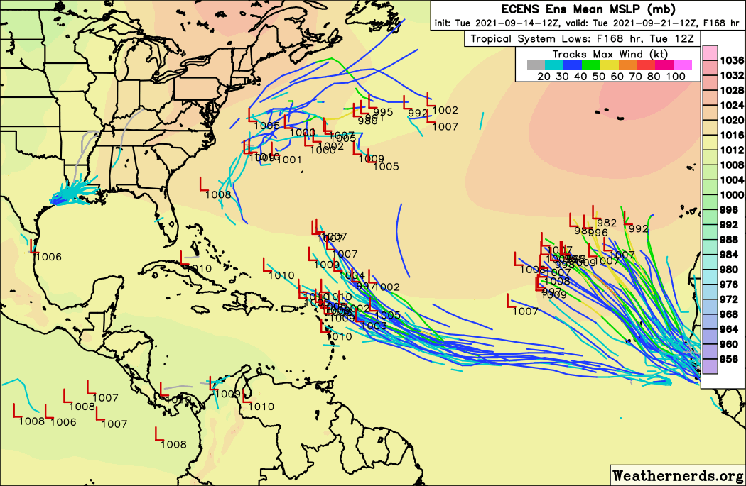
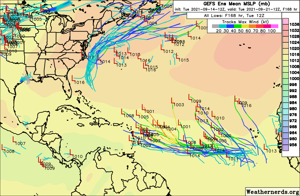
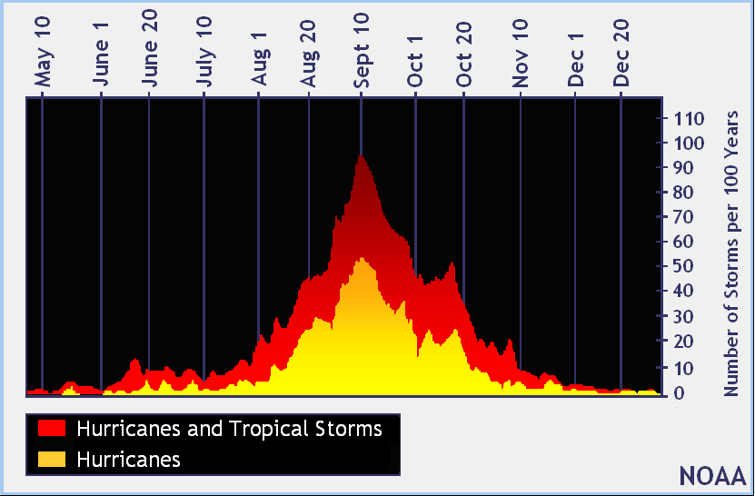
AlphaToOmega wrote:There is one rule of hurricane seasons: never doubt September. Should these runs verify, 2021 would have Rose by September 21. The only seasons with the 17th storm in September are 2020, 2005, and 2011. If another storm forms between September 21 and September 30, it would put 2021 ahead of 2005. At this point, October is likely going to be the decisive month; it will determine whether or not the hurricane season flops (like 2011) or gets put in the history books (like 2005 and 2020).
https://i.postimg.cc/KvMYzfgb/ecens-2021-09-14-12-Z-168-50-258-0-350-MSLP-Surface-tracks-lows.png
https://i.postimg.cc/fRQR0dx9/gefs-2021-09-14-12-Z-168-50-258-0-350-MSLP-Surface-tracks-lows.png
We saw this months ago. Run after run, the CanSIPS shows -VP over Africa and the Indian Ocean, leading to an active hurricane season.
https://i.postimg.cc/W1KLkcRf/cansips-chi200-global-1.png
https://i.postimg.cc/bvtX0VpY/cansips-chi200-global-2.png
https://i.postimg.cc/wvXSZt1S/cansips-chi200-global-3.png
https://i.postimg.cc/3N3PTKpW/cansips-chi200-global-4.png
aspen wrote:If the tropics continue to underwhelm worldwide after Chanthu/Larry/Nicholas, could this be foreshadowing a circulation collapse next year like in 2013? I recall people saying that 2012’s struggle storms (lots of formation but lots not reaching their full potential) was a sign of what was to come next season.

SconnieCane wrote:AlphaToOmega wrote:There is one rule of hurricane seasons: never doubt September. Should these runs verify, 2021 would have Rose by September 21. The only seasons with the 17th storm in September are 2020, 2005, and 2011. If another storm forms between September 21 and September 30, it would put 2021 ahead of 2005. At this point, October is likely going to be the decisive month; it will determine whether or not the hurricane season flops (like 2011) or gets put in the history books (like 2005 and 2020).
https://i.postimg.cc/KvMYzfgb/ecens-2021-09-14-12-Z-168-50-258-0-350-MSLP-Surface-tracks-lows.png
https://i.postimg.cc/fRQR0dx9/gefs-2021-09-14-12-Z-168-50-258-0-350-MSLP-Surface-tracks-lows.png
We saw this months ago. Run after run, the CanSIPS shows -VP over Africa and the Indian Ocean, leading to an active hurricane season.
https://i.postimg.cc/W1KLkcRf/cansips-chi200-global-1.png
https://i.postimg.cc/bvtX0VpY/cansips-chi200-global-2.png
https://i.postimg.cc/wvXSZt1S/cansips-chi200-global-3.png
https://i.postimg.cc/3N3PTKpW/cansips-chi200-global-4.png
As I posted on another forum...
"Well, this season may not be playing out exactly like us weenies had anticipated, but just like last season, just about everything is making landfall, most of it in the CONUS."
What I mean by this is that while far from a flop of a season already, 2021 (also much like 2020) has lacked the one thing I was most interested to see (and I doubt I was alone in this), which was for at least one of those landfall threats to emanate from a quick-developing AEW which goes the distance, with days and days (not just the 6-12 hours before landfall) of stadium-eye satellite stuff, >40 ACE, and nail-biting watching the model tracks windshield wiper back and forth. With Larry, it was pretty clear from the get-go that it was going to be a non-factor at least in terms of the CONUS and points south/southeast, and we thought 95L had the potential to be this but that has appeared to fall apart in recent days with both track and intensity, although it's too completely rule it out as a potential threat down the line.
aspen wrote:If the tropics continue to underwhelm worldwide after Chanthu/Larry/Nicholas, could this be foreshadowing a circulation collapse next year like in 2013? I recall people saying that 2012’s struggle storms (lots of formation but lots not reaching their full potential) was a sign of what was to come next season.

aspen wrote:If the tropics continue to underwhelm worldwide after Chanthu/Larry/Nicholas, could this be foreshadowing a circulation collapse next year like in 2013? I recall people saying that 2012’s struggle storms (lots of formation but lots not reaching their full potential) was a sign of what was to come next season.

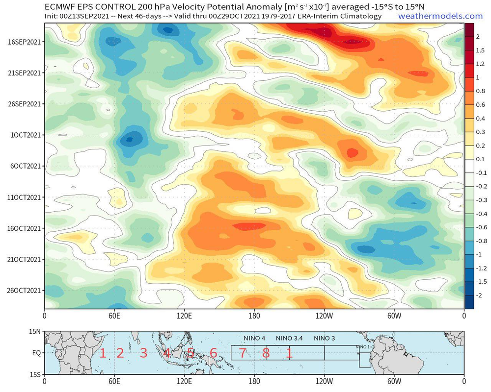
AlphaToOmega wrote:Right now, there is sinking air in the Atlantic; there has been sinking air in the Atlantic for a week or so at this point. The reasons there has been activity are the African Standing Wave and climatology.
The ECMWF shows an African Standing Wave all the way through October. A weak CCKW should create a burst of activity at the end of September. A strong CCKW should create another burst of activity in the middle of October. Climatologically, October is not as favorable as September, but it still counts as part of the peak of hurricane season; and the month could still produce give or take 5-6 storms given these factors.
Should this verify, it would virtually guarantee that 2021 will rival 2020 and 2005 in terms of activity. The thing that will likely determine if 2021 breaks the records of 2020 and 2005 is how active November and December are.
https://i.postimg.cc/JnNpbq5S/241222563-1496350387385525-5844399051510248176-n.png
aspen wrote:If the tropics continue to underwhelm worldwide after Chanthu/Larry/Nicholas, could this be foreshadowing a circulation collapse next year like in 2013? I recall people saying that 2012’s struggle storms (lots of formation but lots not reaching their full potential) was a sign of what was to come next season.
Weather Dude wrote:I don't really get where the notion that this season is underperforming is coming from. I mean, Larry was 10kts less than forecasted, which isn't much at all. Nothing else has really underperformed this year. We're already at 3 majors, which is around the average for an entire season. So... I'm not seeing an underperforming season.
Weather Dude wrote:I don't really get where the notion that this season is underperforming is coming from. I mean, Larry was 10kts less than forecasted, which isn't much at all. Nothing else has really underperformed this year. We're already at 3 majors, which is around the average for an entire season. So... I'm not seeing an underperforming season.
Weather Dude wrote:I don't really get where the notion that this season is underperforming is coming from. I mean, Larry was 10kts less than forecasted, which isn't much at all. Nothing else has really underperformed this year. We're already at 3 majors, which is around the average for an entire season. So... I'm not seeing an underperforming season.
aspen wrote:If the tropics continue to underwhelm worldwide after Chanthu/Larry/Nicholas, could this be foreshadowing a circulation collapse next year like in 2013? I recall people saying that 2012’s struggle storms (lots of formation but lots not reaching their full potential) was a sign of what was to come next season.
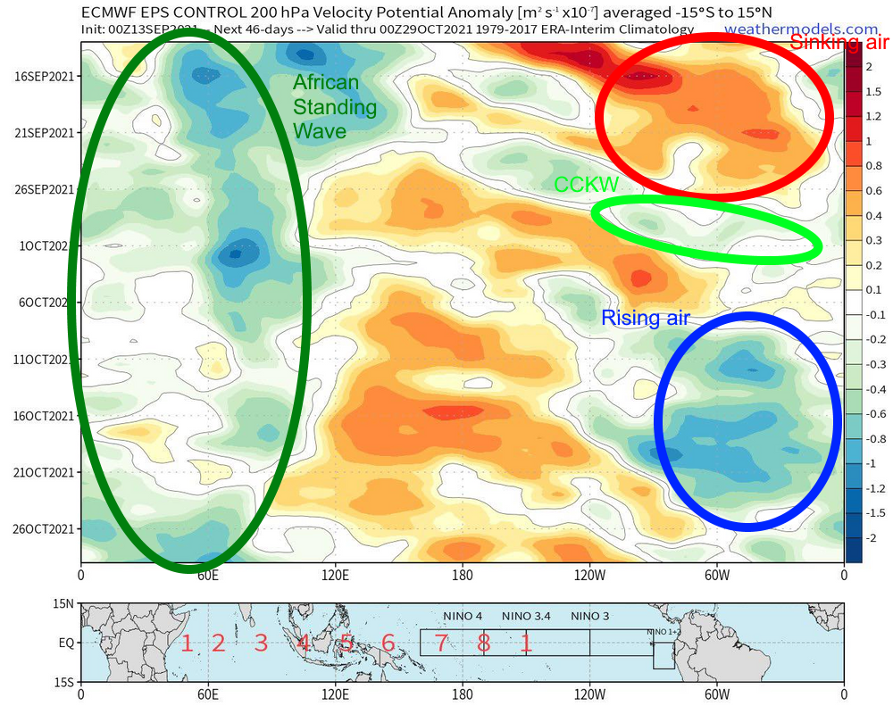
Weather Dude wrote:AlphaToOmega wrote:Right now, there is sinking air in the Atlantic; there has been sinking air in the Atlantic for a week or so at this point. The reasons there has been activity are the African Standing Wave and climatology.
The ECMWF shows an African Standing Wave all the way through October. A weak CCKW should create a burst of activity at the end of September. A strong CCKW should create another burst of activity in the middle of October. Climatologically, October is not as favorable as September, but it still counts as part of the peak of hurricane season; and the month could still produce give or take 5-6 storms given these factors.
Should this verify, it would virtually guarantee that 2021 will rival 2020 and 2005 in terms of activity. The thing that will likely determine if 2021 breaks the records of 2020 and 2005 is how active November and December are.
https://i.postimg.cc/JnNpbq5S/241222563-1496350387385525-5844399051510248176-n.png
2021 almost certainly will not get anywhere close to 2005 or 2020 levels of activity. Just because a favorable phase is coming up does not guarantee record levels of activity.
Users browsing this forum: Ulf and 169 guests


