ATL: PETER - Models
Moderator: S2k Moderators
Re: ATL: INVEST 95L - Models
The only thing saving the SE from getting hit this run is that shortwave trough in the atlantic. If that wasn't there then the ridge would be to strong to turn 95L out to sea.
1 likes
-
SouthFLTropics

- Category 5

- Posts: 4258
- Age: 50
- Joined: Thu Aug 14, 2003 8:04 am
- Location: Port St. Lucie, Florida
Re: ATL: INVEST 95L - Models
IcyTundra wrote:The only thing saving the SE from getting hit this run is that shortwave trough in the atlantic. If that wasn't there then the ridge would be to strong to turn 95L out to sea.
SE gets spared this run but I'm not so sure that the NE doesn't get smacked.
0 likes
Fourth Generation Florida Native
Personal Storm History: David 79, Andrew 92, Erin 95, Floyd 99, Irene 99, Frances 04, Jeanne 04, Wilma 05, Matthew 16, Irma 17, Ian 22, Nicole 22, Milton 24
Personal Storm History: David 79, Andrew 92, Erin 95, Floyd 99, Irene 99, Frances 04, Jeanne 04, Wilma 05, Matthew 16, Irma 17, Ian 22, Nicole 22, Milton 24
-
SouthFLTropics
- Category 5
- Posts: 4258
- Age: 50
- Joined: Thu Aug 14, 2003 8:04 am
- Location: Port St. Lucie, Florida
Re: ATL: INVEST 95L - Models
Yep, Boston and Cape Cod take a direct hit.
0 likes
Fourth Generation Florida Native
Personal Storm History: David 79, Andrew 92, Erin 95, Floyd 99, Irene 99, Frances 04, Jeanne 04, Wilma 05, Matthew 16, Irma 17, Ian 22, Nicole 22, Milton 24
Personal Storm History: David 79, Andrew 92, Erin 95, Floyd 99, Irene 99, Frances 04, Jeanne 04, Wilma 05, Matthew 16, Irma 17, Ian 22, Nicole 22, Milton 24
-
SouthFLTropics
- Category 5
- Posts: 4258
- Age: 50
- Joined: Thu Aug 14, 2003 8:04 am
- Location: Port St. Lucie, Florida
Re: ATL: INVEST 95L - Models
HMON is much slower and further SE than the 18z.
0 likes
Fourth Generation Florida Native
Personal Storm History: David 79, Andrew 92, Erin 95, Floyd 99, Irene 99, Frances 04, Jeanne 04, Wilma 05, Matthew 16, Irma 17, Ian 22, Nicole 22, Milton 24
Personal Storm History: David 79, Andrew 92, Erin 95, Floyd 99, Irene 99, Frances 04, Jeanne 04, Wilma 05, Matthew 16, Irma 17, Ian 22, Nicole 22, Milton 24
-
ElectricStorm

- Category 5
- Posts: 5147
- Age: 25
- Joined: Tue Aug 13, 2019 11:23 pm
- Location: Norman, OK
Re: ATL: INVEST 95L - Models
Man the NE gets hit with a major this run. Yeah that's not happening but at least it's entertaining  Gotta love fantasy land GFS
The major near Bahamas part of the run is certainly possible though
The major near Bahamas part of the run is certainly possible though
0 likes
B.S Meteorology, University of Oklahoma '25
Please refer to the NHC, NWS, or SPC for official information.
Please refer to the NHC, NWS, or SPC for official information.
Re: ATL: INVEST 95L - Models
00Z GFS wants the Long Island Express 2.0. Good thing that it won't happen but it is some nice eye candy.
0 likes
Re: ATL: INVEST 95L - Models
Major Hurricane making landfall in Maine. Yep this sure takes the cake for craziest GFS fantasyland run this season.
0 likes


Re: ATL: INVEST 95L - Models
06z GFS once again survives the TUTT. Strangely, another TC randomly forms next Wednesday ahead of 95L and makes landfall in the Carolinas. This is the first run of any model I’ve seen to show such a system.
Update: passes between the US and Bermuda like Earl ‘10, peaking as a strong Cat 3 or weak Cat 4.
Update: passes between the US and Bermuda like Earl ‘10, peaking as a strong Cat 3 or weak Cat 4.
0 likes
Irene '11 Sandy '12 Hermine '16 5/15/2018 Derecho Fay '20 Isaias '20 Elsa '21 Henri '21 Ida '21
I am only a meteorology enthusiast who knows a decent amount about tropical cyclones. Look to the professional mets, the NHC, or your local weather office for the best information.
I am only a meteorology enthusiast who knows a decent amount about tropical cyclones. Look to the professional mets, the NHC, or your local weather office for the best information.
-
SouthFLTropics
- Category 5
- Posts: 4258
- Age: 50
- Joined: Thu Aug 14, 2003 8:04 am
- Location: Port St. Lucie, Florida
Re: ATL: INVEST 95L - Models
I have to wonder what that run would have looked like had that other system not developed off of the Carolinas.
Sent from my iPhone using Tapatalk
Sent from my iPhone using Tapatalk
0 likes
Fourth Generation Florida Native
Personal Storm History: David 79, Andrew 92, Erin 95, Floyd 99, Irene 99, Frances 04, Jeanne 04, Wilma 05, Matthew 16, Irma 17, Ian 22, Nicole 22, Milton 24
Personal Storm History: David 79, Andrew 92, Erin 95, Floyd 99, Irene 99, Frances 04, Jeanne 04, Wilma 05, Matthew 16, Irma 17, Ian 22, Nicole 22, Milton 24
Re: ATL: INVEST 95L - Models
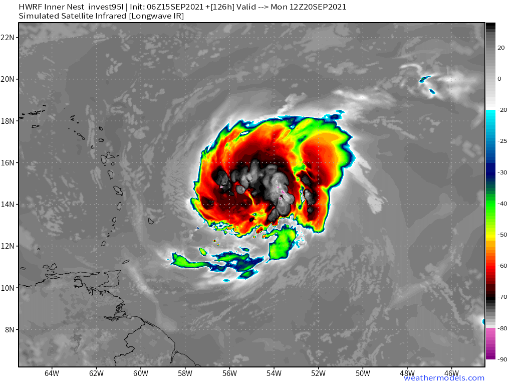
6z HWRF takes forever to develop 95L, and it only gets it to a mid-grade TS before weakening begins on Monday.
Edit: actually it’s only a quick weakening before it resumes strengthening. This run is back to being on the SW side of the model guidance, and puts 95L at around 15N/55W by 126hr.
Edit: actually it’s only a quick weakening before it resumes strengthening. This run is back to being on the SW side of the model guidance, and puts 95L at around 15N/55W by 126hr.
0 likes
Irene '11 Sandy '12 Hermine '16 5/15/2018 Derecho Fay '20 Isaias '20 Elsa '21 Henri '21 Ida '21
I am only a meteorology enthusiast who knows a decent amount about tropical cyclones. Look to the professional mets, the NHC, or your local weather office for the best information.
I am only a meteorology enthusiast who knows a decent amount about tropical cyclones. Look to the professional mets, the NHC, or your local weather office for the best information.
-
Blown Away

- S2K Supporter

- Posts: 10253
- Joined: Wed May 26, 2004 6:17 am
Re: ATL: INVEST 95L - Models
aspen wrote:6z HWRF takes forever to develop 95L, and it only gets it to a mid-grade TS before weakening begins on Monday.

06z HWRF... Finishes 2 degrees S and 4-5 degrees W of 00z... Finishes as moderate TS compared to Cat 1 on 00z... It seems if 95L delays significant development until after @50W or remains a weaker/shallower TD/TS it may impact the NE Caribbean/GA... NHC says 90% of development, so I'm assuming 95L gets named...
0 likes
Hurricane Eye Experience: David 79, Irene 99, Frances 04, Jeanne 04, Wilma 05… Hurricane Brush Experience: Andrew 92, Erin 95, Floyd 99, Matthew 16, Irma 17, Ian 22, Nicole 22…
-
SFLcane

- S2K Supporter
- Posts: 10281
- Age: 48
- Joined: Sat Jun 05, 2010 1:44 pm
- Location: Lake Worth Florida
Re: ATL: INVEST 95L - Models
SouthFLTropics wrote:I have to wonder what that run would have looked like had that other system not developed off of the Carolinas.
Sent from my iPhone using Tapatalk
+1
If it’s a ghost storm look out below.
0 likes
-
SFLcane
- S2K Supporter
- Posts: 10281
- Age: 48
- Joined: Sat Jun 05, 2010 1:44 pm
- Location: Lake Worth Florida
Re: ATL: INVEST 95L - Models
Takes forever to develop based on satellite this thing is in no hurry so it might be right.
2 likes
-
AutoPenalti
- Category 5
- Posts: 4091
- Age: 29
- Joined: Mon Aug 17, 2015 4:16 pm
- Location: Ft. Lauderdale, Florida
Re: ATL: INVEST 95L - Models
Well now this is got slightly more interesting.
3 likes
The posts in this forum are NOT official forecasts and should not be used as such. They are just the opinion of the poster and may or may not be backed by sound meteorological data. They are NOT endorsed by any professional institution or STORM2K. For official information, please refer to products from the NHC and NWS.
Model Runs Cheat Sheet:
GFS (5:30 AM/PM, 11:30 AM/PM)
HWRF, GFDL, UKMET, NAVGEM (6:30-8:00 AM/PM, 12:30-2:00 AM/PM)
ECMWF (1:45 AM/PM)
TCVN is a weighted averaged
Re: ATL: INVEST 95L - Models
SFLcane wrote:Takes forever to develop based on satellite this thing is in no hurry so it might be right.
https://i.postimg.cc/rwHLNF6M/990336-D3-47-BE-4779-9-D0-E-FDFA7-C9064-FE.png
In this scenario, 95L could attempt a RI phase (the UL environment is decent and it’s over 28.5-29.5C SSTs with good OHC), but the TUTT awaits further NE. Anything from a weak TS to a low-end major is possible in this type of track depending on how 95L puts itself together on Saturday and Sunday. The slower 95L develops in the 3-5 day range, the more likely it’ll be killed by the TUTT.
Part of the reason for the slow development could be the offset of the mid-level spin (~12N) from the main center of vorticity (~10N), and over the next few days the spin and northern lobe rotate down towards the main vort, with 95L concentrating at 10-11N like the GFS/HWRF have been showing.
0 likes
Irene '11 Sandy '12 Hermine '16 5/15/2018 Derecho Fay '20 Isaias '20 Elsa '21 Henri '21 Ida '21
I am only a meteorology enthusiast who knows a decent amount about tropical cyclones. Look to the professional mets, the NHC, or your local weather office for the best information.
I am only a meteorology enthusiast who knows a decent amount about tropical cyclones. Look to the professional mets, the NHC, or your local weather office for the best information.
-
AutoPenalti
- Category 5
- Posts: 4091
- Age: 29
- Joined: Mon Aug 17, 2015 4:16 pm
- Location: Ft. Lauderdale, Florida
Re: ATL: INVEST 95L - Models
Huh... that low off the Carolinas wasn't there last night.

1 likes
The posts in this forum are NOT official forecasts and should not be used as such. They are just the opinion of the poster and may or may not be backed by sound meteorological data. They are NOT endorsed by any professional institution or STORM2K. For official information, please refer to products from the NHC and NWS.
Model Runs Cheat Sheet:
GFS (5:30 AM/PM, 11:30 AM/PM)
HWRF, GFDL, UKMET, NAVGEM (6:30-8:00 AM/PM, 12:30-2:00 AM/PM)
ECMWF (1:45 AM/PM)
TCVN is a weighted averaged
-
RevanTheJedi96
- Tropical Storm

- Posts: 106
- Joined: Wed Sep 01, 2021 10:40 am
Re: ATL: INVEST 95L - Models
IcyTundra wrote:00Z GFS wants the Long Island Express 2.0. Good thing that it won't happen but it is some nice eye candy.
It absolutely 100% could happen. New England is severely overdue for a hurricane and has gotten insanely lucky since Bob.
3 likes
-
Stormybajan

- Category 1

- Posts: 453
- Joined: Thu May 20, 2021 3:21 pm
- Location: Windward Islands
Re: ATL: INVEST 95L - Models
SFLcane wrote:https://twitter.com/osuwxguy/status/1438128631113469953?
Wouldnt this cause for the vorticity to jump north then instead? Doesnt vorticity always follow the convection? Like what the euro shows
1 likes
Sad West Indies and Manchester United fan ⚽️
Who is online
Users browsing this forum: No registered users and 50 guests