ATL: ROSE - Post-Tropical - Discussion
Moderator: S2k Moderators

Re: ATL: INVEST 97L - Discussion
97L is still somewhat entangled in the monsoon trough (based on surface and vorticity analysis). May have prevented earlier designation, but the system is improving by the minute.
1 likes
Kendall -> SLO -> PBC
Memorable Storms: Katrina (for its Florida landfall...) Wilma Matthew Irma
Memorable Storms: Katrina (for its Florida landfall...) Wilma Matthew Irma

Re: ATL: INVEST 97L - Discussion
With the recent ASCAT pass on 95L and buoy data, we could be getting a rare double classification tonight...
With Olga/Pablo in 2019, Olga was already designated as 17L before Pablo was designated. This is probably the first time we could potentially see two invests become named storms at exactly the same time, meaning both the name and the storm number could be given out simultaneously. I can't think of any other time this has happened, especially given how hard it is for something like this to occur.
With Olga/Pablo in 2019, Olga was already designated as 17L before Pablo was designated. This is probably the first time we could potentially see two invests become named storms at exactly the same time, meaning both the name and the storm number could be given out simultaneously. I can't think of any other time this has happened, especially given how hard it is for something like this to occur.
3 likes
-
Category5Kaiju

- Category 5

- Posts: 4338
- Joined: Thu Dec 24, 2020 12:45 pm
- Location: Seattle during the summer, Phoenix during the winter
Re: ATL: INVEST 97L - Discussion
zhukm29 wrote:With the recent ASCAT pass on 95L and buoy data, we could be getting a rare double classification tonight...
With Olga/Pablo in 2019, Olga was already designated as 17L before Pablo was designated. This is probably the first time we could potentially see two invests become named storms at exactly the same time, meaning both the name and the storm number could be given out simultaneously. I can't think of any other time this has happened, especially given how hard it is for something like this to occur.
If something like that happens, I wonder which will be which. Does the more eastern storm get the earlier lettered name?
1 likes
Unless explicitly stated, all information in my posts is based on my own opinions and observations. Tropical storms and hurricanes can be extremely dangerous. Refer to an accredited weather research agency or meteorologist if you need to make serious decisions regarding an approaching storm.

Re: ATL: INVEST 97L - Discussion
The 12z HWRF has a favorable UL environment for 97L's last 12 hours or so over >26C SSTs before running into a wall of shear. Since it is likely already a TC, the HWRF probably has not initialized it well, so it could potentially get stronger. A Cat 1 is not impossible.


The continued convective burst should help 97L's developing LLC fully detach from the ITCZ/Monsoon trough.

The continued convective burst should help 97L's developing LLC fully detach from the ITCZ/Monsoon trough.
2 likes
Irene '11 Sandy '12 Hermine '16 5/15/2018 Derecho Fay '20 Isaias '20 Elsa '21 Henri '21 Ida '21
I am only a meteorology enthusiast who knows a decent amount about tropical cyclones. Look to the professional mets, the NHC, or your local weather office for the best information.
I am only a meteorology enthusiast who knows a decent amount about tropical cyclones. Look to the professional mets, the NHC, or your local weather office for the best information.

Re: ATL: INVEST 97L - Discussion
InfernoFlameCat wrote:They (NHC) might make a special advisory for this one. Looks pretty good right now.
I doubt they would given it's nowhere near land and isn't rapidly intensifying but we'll probably get the 'if this trend continues' wording in an hour.
0 likes
The above post is not official and should not be used as such. It is the opinion of the poster and may or may not be backed by sound meteorological data. It is not endorsed by any professional institution or storm2k.org. For official information, please refer to the NHC and NWS products.
Re: ATL: INVEST 97L - Discussion
Hammy wrote:InfernoFlameCat wrote:They (NHC) might make a special advisory for this one. Looks pretty good right now.
I doubt they would given it's nowhere near land and isn't rapidly intensifying but we'll probably get the 'if this trend continues' wording in an hour.
They did not go with that. Just up to 70/70 and saying a TD will form in the next day or two. We’ll probably need a really good ASCAT pass to upgrade this, even though it’s probably a TC already.
2 likes
Irene '11 Sandy '12 Hermine '16 5/15/2018 Derecho Fay '20 Isaias '20 Elsa '21 Henri '21 Ida '21
I am only a meteorology enthusiast who knows a decent amount about tropical cyclones. Look to the professional mets, the NHC, or your local weather office for the best information.
I am only a meteorology enthusiast who knows a decent amount about tropical cyclones. Look to the professional mets, the NHC, or your local weather office for the best information.
-
Yellow Evan

- Professional-Met

- Posts: 16242
- Age: 27
- Joined: Fri Jul 15, 2011 12:48 pm
- Location: Henderson, Nevada/Honolulu, HI
- Contact:
Re: ATL: INVEST 97L - Discussion
Showers and thunderstorms are also showing signs of organization in
association with a low pressure system located over the far eastern
Atlantic a few hundred miles south-southwest of the Cabo Verde
Islands. Environmental conditions appear conducive for further
development of this system, and a tropical depression is likely to
form during the next day or two while moving toward the northwest at
10 to 15 mph to the west of the Cabo Verde Islands. This system is
expected to reach cooler waters and an area of stronger upper-level
winds early next week, which should limit its development.
* Formation chance through 48 hours...high...70 percent.
* Formation chance through 5 days...high...70 percent.
0 likes
-
Yellow Evan
- Professional-Met
- Posts: 16242
- Age: 27
- Joined: Fri Jul 15, 2011 12:48 pm
- Location: Henderson, Nevada/Honolulu, HI
- Contact:
Re: ATL: INVEST 97L - Discussion
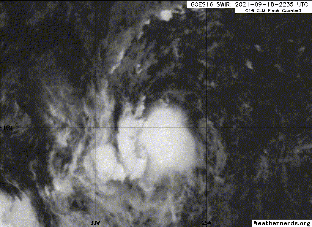
TXNT23 KNES 190006
TCSNTL
A. TROPICAL DISTURBANCE (97L)
B. 18/2330Z
C. 9.5N
D. 27.0W
E. THREE/MET-11
F. T1.5/1.5
G. IR/EIR/SWIR
H. REMARKS...3/10 BANDING WAS OBSERVED AROUND THE LLCC WHICH RESULTS IN A
DT EQUAL TO 1.5. THE MET AND PT AGREE WITH THE DT. PERSISTENT CONVECTION
WAS OBSERVED TO THE WEST NEAR THE REGION OF THE LLCC. THE FT IS BASED
ON THE DT.
I. ADDL POSITIONS
NIL
...SAMBUCCI
0 likes
-
cycloneye

- Admin

- Posts: 149550
- Age: 69
- Joined: Thu Oct 10, 2002 10:54 am
- Location: San Juan, Puerto Rico
Re: ATL: INVEST 97L - Discussion
3 likes
Visit the Caribbean-Central America Weather Thread where you can find at first post web cams,radars
and observations from Caribbean basin members Click Here
and observations from Caribbean basin members Click Here
Re: ATL: INVEST 97L - Discussion
The post-season best track will probably have the time of genesis revised to midday today. I’m still surprised the NHC has seemingly been lagging a bit behind with it.
3 likes
Irene '11 Sandy '12 Hermine '16 5/15/2018 Derecho Fay '20 Isaias '20 Elsa '21 Henri '21 Ida '21
I am only a meteorology enthusiast who knows a decent amount about tropical cyclones. Look to the professional mets, the NHC, or your local weather office for the best information.
I am only a meteorology enthusiast who knows a decent amount about tropical cyclones. Look to the professional mets, the NHC, or your local weather office for the best information.
-
ouragans

- Category 2

- Posts: 501
- Age: 54
- Joined: Sun Jun 12, 2011 12:09 pm
- Location: Abymes, Guadeloupe F.W.I
- Contact:
Re: ATL: INVEST 97L - Discussion
97L page is no longer accessible on RAMMB...
EDIT: and best track wind speed upped to 30 kts
EDIT: and best track wind speed upped to 30 kts
Invest 97L
As of 00:00 UTC Sep 19, 2021:
Location: 10.5°N 27.3°W
Maximum Winds: 30 kt Gusts: N/A
Minimum Central Pressure: 1008 mb
Environmental Pressure: N/A
Radius of Circulation: N/A
Radius of Maximum wind: 70 nm
As of 00:00 UTC Sep 19, 2021:
Location: 10.5°N 27.3°W
Maximum Winds: 30 kt Gusts: N/A
Minimum Central Pressure: 1008 mb
Environmental Pressure: N/A
Radius of Circulation: N/A
Radius of Maximum wind: 70 nm
0 likes
Personal forecast disclaimer
This post is a personal point of view, not an information. Please refer to official statements for life-threatening decisions.
David '79, Frederic '79, Hugo '89, Iris, Luis & Marilyn '95, Georges '98, Lenny '99, Dean '07, Irma '17, Maria '17, Fiona '22, Philippe '23, Tammy '23
16°13'33.3,"6N -61°36'39.5"W
-
Sciencerocks
- Category 5
- Posts: 10186
- Age: 40
- Joined: Thu Jul 06, 2017 1:51 am
Re: ATL: INVEST 97L - Discussion
cycloneye wrote:https://twitter.com/webberweather/status/1439387525236232198
A bit off topic, but I could've sworn Webb worked at NHC.
0 likes
The above post is not official and should not be used as such. It is the opinion of the poster and may or may not be backed by sound meteorological data. It is not endorsed by any professional institution or storm2k.org. For official information, please refer to the NHC and NWS products.
Re: ATL: INVEST 97L - Discussion
I guess we'll have to wait until tomorrow for designation, kind of strange they still aren't classifying it. They're the experts though so they probably have a reason, but 97L has looked like a bona fide tropical cyclone for a while now, supported by ASCAT earlier as well. As a point of reference, here is Wilfred last year, in a pretty similar location with almost the exact same look, but it was classified much earlier.
https://twitter.com/philklotzbach/status/1306966237335810049
https://twitter.com/philklotzbach/status/1306966237335810049
3 likes
-
Sciencerocks
- Category 5
- Posts: 10186
- Age: 40
- Joined: Thu Jul 06, 2017 1:51 am

-
Sciencerocks
- Category 5
- Posts: 10186
- Age: 40
- Joined: Thu Jul 06, 2017 1:51 am
Re: ATL: INVEST 97L - Discussion
Tropical Weather Outlook
NWS National Hurricane Center Miami FL
200 AM EDT Sun Sep 19 2021
For the North Atlantic...Caribbean Sea and the Gulf of Mexico:
The National Hurricane Center is issuing advisories on newly formed
Tropical Depression Sixteen, located a several hundred miles east of
the northern Leeward Island.
Recent satellite-derived wind data indicate that the small low
pressure system located over the far eastern tropical Atlantic a few
hundred miles south-southwest of the Cabo Verde Islands has become
better defined. Associated thunderstorm activity has also become
more concentrated near the center, and environmental conditions are
conducive for a tropical depression to form later this morning while
the low moves generally northwestward at 10 to 15 mph, well to the
west of the Cabo Verde Islands.
* Formation chance through 48 hours...high...90 percent.
* Formation chance through 5 days...high...90 percent.
0 likes
Re: ATL: SEVENTEEN - Tropical Depression - Discussion
AL, 17, 2021091906, , BEST, 0, 113N, 279W, 30, 1007, TD, 34, NEQ, 0, 0, 0, 0, 1012, 100, 30, 0, 0, L, 0, , 0, 0, SEVENTEEN, M, 0, , 0, 0, 0, 0, genesis-num, 036, TRANSITIONED, alC72021 to al172021,
2 likes
Re: ATL: INVEST 97L - Discussion
Is this the one that has now been classified as TD17? Looks like another year where many storms struggle in the MDR.
So many storms in the MDR over the last three years has been like this:
https://www.youtube.com/watch?v=oC_qLPJlGks
So many storms in the MDR over the last three years has been like this:
https://www.youtube.com/watch?v=oC_qLPJlGks
0 likes

Re: ATL: INVEST 97L - Discussion
Hammy wrote:cycloneye wrote:https://twitter.com/webberweather/status/1439387525236232198
A bit off topic, but I could've sworn Webb worked at NHC.
Mr. Webb actually lives in NM.
1 likes
Personal Forecast Disclaimer:
The posts in this forum are NOT official forecasts and should not be used as such. They are just the opinion of the poster and may or may not be backed by sound meteorological data. They are NOT endorsed by any professional institution or storm2k.org. For official information, please refer to the NHC and NWS products.
The posts in this forum are NOT official forecasts and should not be used as such. They are just the opinion of the poster and may or may not be backed by sound meteorological data. They are NOT endorsed by any professional institution or storm2k.org. For official information, please refer to the NHC and NWS products.
Re: ATL: INVEST 97L - Discussion
This looked better last night. While shear is low, there’s dry air all over the place that the NHC says will limit the system. Its current presentation suggests it has ingested some. Hopefully it’s able to mix it out and intensify because it’s not going to be impacting anyone.
0 likes
Irene '11 Sandy '12 Hermine '16 5/15/2018 Derecho Fay '20 Isaias '20 Elsa '21 Henri '21 Ida '21
I am only a meteorology enthusiast who knows a decent amount about tropical cyclones. Look to the professional mets, the NHC, or your local weather office for the best information.
I am only a meteorology enthusiast who knows a decent amount about tropical cyclones. Look to the professional mets, the NHC, or your local weather office for the best information.
Who is online
Users browsing this forum: No registered users and 11 guests