ATL: SAM - Models

Moderator: S2k Moderators

Message
Author
User avatar
aspen
Category 5
Category 5
Posts: 8818
Joined: Sat Oct 12, 2019 7:10 pm
Location: Connecticut, USA

Re: ATL: INVEST 98L - Models

#381 Postby aspen » Tue Sep 21, 2021 7:11 pm

skyline385 wrote:
aspen wrote:
skyline385 wrote:
Uhm isnt the HWRF-P (afaik P is Parent and not Parallel) the same as HWRF?

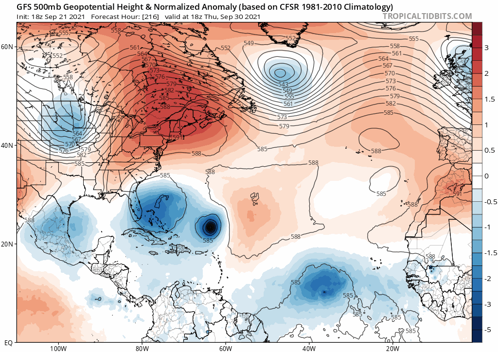
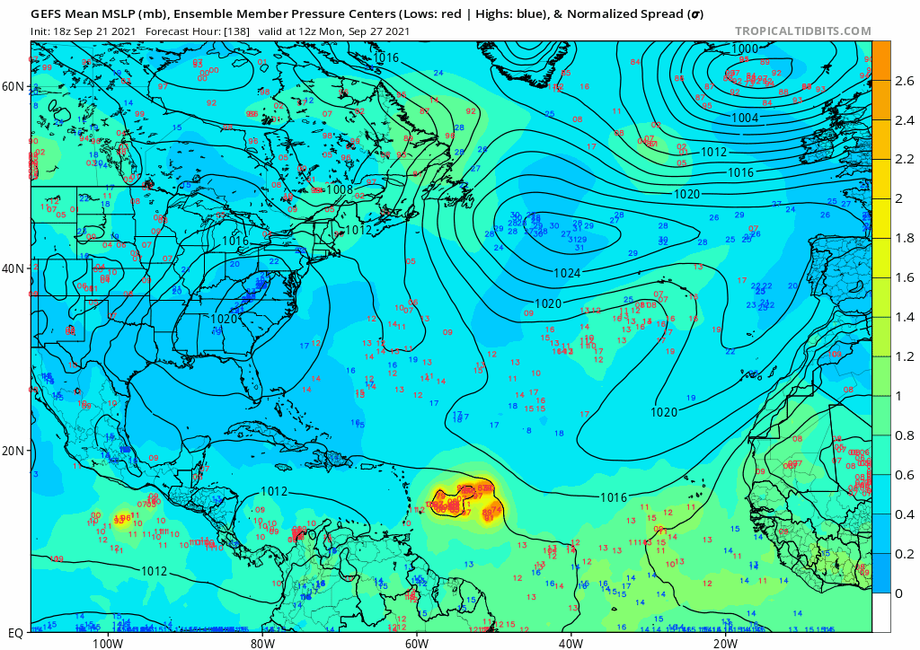
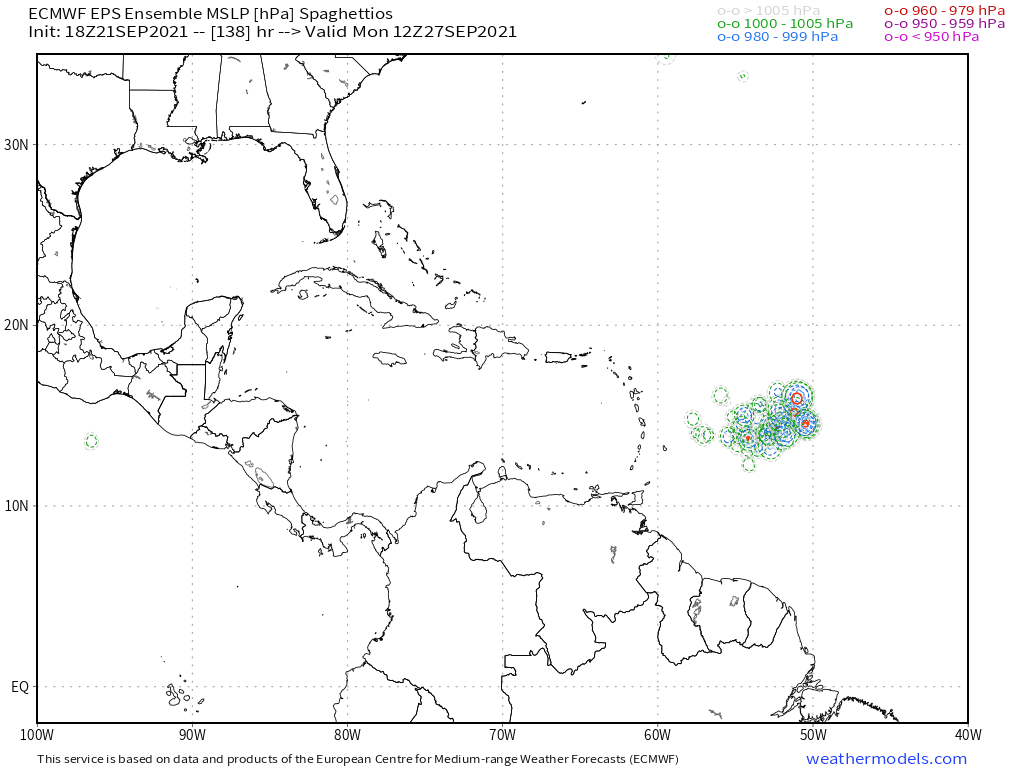
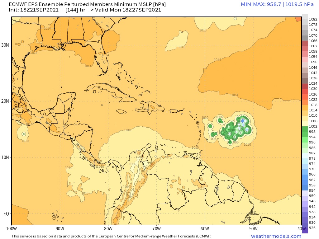
Due to its wider field of view, it likes to get its focus stuck on whatever low pressure area happens to be even a tiny bit deeper than the disturbance it’s supposed to be focusing on. There’s been this low over central Africa that the HWRF-P has gotten stuck on for many early runs of Peter and 98L.


So its a different run of the HWRF then?

No it shows the same storm evolution and environmental factors as the HWRF; it just has a wider FOV.
2 likes   
Irene '11 Sandy '12 Hermine '16 5/15/2018 Derecho Fay '20 Isaias '20 Elsa '21 Henri '21 Ida '21

I am only a meteorology enthusiast who knows a decent amount about tropical cyclones. Look to the professional mets, the NHC, or your local weather office for the best information.

User avatar
SFLcane
S2K Supporter
S2K Supporter
Posts: 10163
Age: 47
Joined: Sat Jun 05, 2010 1:44 pm
Location: Lake Worth Florida

Re: ATL: INVEST 98L - Models

#382 Postby SFLcane » Tue Sep 21, 2021 7:25 pm

3 likes   

User avatar
Spacecoast
Category 2
Category 2
Posts: 758
Joined: Thu Aug 31, 2017 2:03 pm

Re: ATL: INVEST 98L - Models

#383 Postby Spacecoast » Tue Sep 21, 2021 7:25 pm

18z GEFS:
Image
0 likes   

User avatar
Ubuntwo
Category 5
Category 5
Posts: 1406
Age: 31
Joined: Thu Oct 05, 2017 10:41 pm

Re: ATL: INVEST 98L - Models

#384 Postby Ubuntwo » Tue Sep 21, 2021 7:26 pm

Comparing the GFS and Euro solutions. The Euro embeds ex-Odette in the mid latitudes and moves it out quickly. The GFS had ridging building back in over and above a subtropical Odette, shunting southward and interacting it with Rose. This whole process weakens the ridging above 98 allowing the system to gain more latitude.

Later in the forecast period, the Euro has a weaker and flatter trough moving across the US. Not only is the trough more amplified on the GFS, but its passage leads to an upper-level low cutting off in the southwest Atlantic (which eventually forms another TC). Lots to watch, most will change...
Last edited by Ubuntwo on Tue Sep 21, 2021 7:38 pm, edited 1 time in total.
0 likes   
Kendall -> SLO -> PBC

Memorable Storms: Katrina (for its Florida landfall...) Wilma Matthew Irma

User avatar
aspen
Category 5
Category 5
Posts: 8818
Joined: Sat Oct 12, 2019 7:10 pm
Location: Connecticut, USA

Re: ATL: INVEST 98L - Models

#385 Postby aspen » Tue Sep 21, 2021 7:34 pm

18z HWRF-P is garbage too. The 10m wind field and simulated IR structure are very low-res and “smooth”; this happens to systems that are not the main focus of the model run. We’ll have to wait until 00z for a good HWRF run.
0 likes   
Irene '11 Sandy '12 Hermine '16 5/15/2018 Derecho Fay '20 Isaias '20 Elsa '21 Henri '21 Ida '21

I am only a meteorology enthusiast who knows a decent amount about tropical cyclones. Look to the professional mets, the NHC, or your local weather office for the best information.

floridasun
Tropical Storm
Tropical Storm
Posts: 200
Joined: Tue Sep 14, 2021 3:59 pm

Re: ATL: INVEST 98L - Models

#386 Postby floridasun » Tue Sep 21, 2021 7:38 pm

GFS vs Euro we will know by sunday the islands will be watching i bet by sunday
0 likes   

jlauderdal
S2K Supporter
S2K Supporter
Posts: 7182
Joined: Wed May 19, 2004 5:46 am
Location: NE Fort Lauderdale
Contact:

Re: RE: Re: ATL: INVEST 98L - Models

#387 Postby jlauderdal » Tue Sep 21, 2021 7:49 pm

Hypercane_Kyle wrote:That GFS run is whack. How does a storm manage to recurve right into a ridge? There's no obvious weakness that I see - just a stout ridge.

Image

EDIT: Ninja'd by Wxtwitter
The gfs has done this before, toss the run
0 likes   

User avatar
skyline385
Category 5
Category 5
Posts: 2728
Age: 35
Joined: Wed Aug 26, 2020 11:15 pm
Location: Houston TX

Re: ATL: INVEST 98L - Models

#388 Postby skyline385 » Tue Sep 21, 2021 7:51 pm


Thats from the 12Z run though?
0 likes   

User avatar
SFLcane
S2K Supporter
S2K Supporter
Posts: 10163
Age: 47
Joined: Sat Jun 05, 2010 1:44 pm
Location: Lake Worth Florida

Re: ATL: INVEST 98L - Models

#389 Postby SFLcane » Tue Sep 21, 2021 7:53 pm

0 likes   

Fancy1001
Category 1
Category 1
Posts: 452
Joined: Thu Jul 16, 2020 10:16 pm

Re: ATL: INVEST 98L - Models

#390 Postby Fancy1001 » Tue Sep 21, 2021 7:54 pm

HMON Is a little weaker but further south west.
0 likes   

User avatar
gatorcane
S2K Supporter
S2K Supporter
Posts: 23691
Age: 47
Joined: Sun Mar 13, 2005 3:54 pm
Location: Boca Raton, FL

Re: ATL: INVEST 98L - Models

#391 Postby gatorcane » Tue Sep 21, 2021 7:58 pm


The GFS is not plowing it into the ridge. That ridge is weakening due to the mid-upper low across the Great Lakes:

Image

All of the GFS ensembles are recurving but are closer to the islands:

Image
1 likes   

floridasun
Tropical Storm
Tropical Storm
Posts: 200
Joined: Tue Sep 14, 2021 3:59 pm

Re: ATL: INVEST 98L - Models

#392 Postby floridasun » Tue Sep 21, 2021 8:07 pm

so who going win the gfs or Euro this runs going drive us cazy next few days so all about high building west or weakness left by peter
0 likes   

AutoPenalti
Category 5
Category 5
Posts: 4030
Age: 29
Joined: Mon Aug 17, 2015 4:16 pm
Location: Ft. Lauderdale, Florida

Re: ATL: INVEST 98L - Models

#393 Postby AutoPenalti » Tue Sep 21, 2021 8:16 pm

That’s not a ridge puncher, it’s the low the forms out of nowhere thanks to the stronger trough. The overall SW correction is concerning though.
0 likes   
The posts in this forum are NOT official forecasts and should not be used as such. They are just the opinion of the poster and may or may not be backed by sound meteorological data. They are NOT endorsed by any professional institution or STORM2K. For official information, please refer to products from the NHC and NWS.


Model Runs Cheat Sheet:
GFS (5:30 AM/PM, 11:30 AM/PM)
HWRF, GFDL, UKMET, NAVGEM (6:30-8:00 AM/PM, 12:30-2:00 AM/PM)
ECMWF (1:45 AM/PM)

TCVN
is a weighted averaged

Keldeo1997
Category 2
Category 2
Posts: 637
Joined: Fri Oct 11, 2019 11:35 pm

Re: ATL: INVEST 98L - Models

#394 Postby Keldeo1997 » Tue Sep 21, 2021 8:21 pm

Image

18Z EPS is even more West.
1 likes   

LarryWx
S2K Supporter
S2K Supporter
Posts: 6305
Joined: Sun Sep 07, 2003 2:04 pm
Location: GA

Re: ATL: INVEST 98L - Models

#395 Postby LarryWx » Tue Sep 21, 2021 8:23 pm

The subtle ominous trend continues with the 18Z EPS.
0 likes   
Personal Forecast Disclaimer:
The posts in this forum are NOT official forecasts and should not be used as such. They are just the opinion of the poster and may or may not be backed by sound meteorological data. They are NOT endorsed by any professional institution or storm2k.org. For official information, please refer to the NHC and NWS products.

User avatar
SFLcane
S2K Supporter
S2K Supporter
Posts: 10163
Age: 47
Joined: Sat Jun 05, 2010 1:44 pm
Location: Lake Worth Florida

Re: ATL: INVEST 98L - Models

#396 Postby SFLcane » Tue Sep 21, 2021 8:27 pm

LarryWx wrote:The subtle ominous trend continues with the 18Z EPS.


Yep…

Image
2 likes   

sma10
Category 5
Category 5
Posts: 1710
Joined: Tue Aug 02, 2005 1:13 pm

Re: ATL: INVEST 98L - Models

#397 Postby sma10 » Tue Sep 21, 2021 8:29 pm

LarryWx wrote:The subtle ominous trend continues with the 18Z EPS.


Larry, you are the "go-to guru" on this type of stuff: the Euro has 98L tracking W to WNW on 10/1 off the N coast of Hispaniola towards the Bahamas. When is the last time you can remember an October storm in that region tracking westerly? Would we have to go all the way back to Inez? Or maybe Kate?
0 likes   

User avatar
skyline385
Category 5
Category 5
Posts: 2728
Age: 35
Joined: Wed Aug 26, 2020 11:15 pm
Location: Houston TX

Re: ATL: INVEST 98L - Models

#398 Postby skyline385 » Tue Sep 21, 2021 8:42 pm

Looks like almost all members shifted west for the 18Z

Image

Image
0 likes   

LarryWx
S2K Supporter
S2K Supporter
Posts: 6305
Joined: Sun Sep 07, 2003 2:04 pm
Location: GA

Re: ATL: INVEST 98L - Models

#399 Postby LarryWx » Tue Sep 21, 2021 8:54 pm

sma10 wrote:
LarryWx wrote:The subtle ominous trend continues with the 18Z EPS.


Larry, you are the "go-to guru" on this type of stuff: the Euro has 98L tracking W to WNW on 10/1 off the N coast of Hispaniola towards the Bahamas. When is the last time you can remember an October storm in that region tracking westerly? Would we have to go all the way back to Inez? Or maybe Kate?


Klaus 1990:

https://www.nhc.noaa.gov/data/tracks/tracks-at-1990.png
2 likes   
Personal Forecast Disclaimer:
The posts in this forum are NOT official forecasts and should not be used as such. They are just the opinion of the poster and may or may not be backed by sound meteorological data. They are NOT endorsed by any professional institution or storm2k.org. For official information, please refer to the NHC and NWS products.

sma10
Category 5
Category 5
Posts: 1710
Joined: Tue Aug 02, 2005 1:13 pm

Re: ATL: INVEST 98L - Models

#400 Postby sma10 » Tue Sep 21, 2021 9:06 pm

LarryWx wrote:
sma10 wrote:
LarryWx wrote:The subtle ominous trend continues with the 18Z EPS.


Larry, you are the "go-to guru" on this type of stuff: the Euro has 98L tracking W to WNW on 10/1 off the N coast of Hispaniola towards the Bahamas. When is the last time you can remember an October storm in that region tracking westerly? Would we have to go all the way back to Inez? Or maybe Kate?


Klaus 1990:

https://www.nhc.noaa.gov/data/tracks/tracks-at-1990.png


Thank you, wow 31 years. And I doubt this one is just going to fizzle away like Klaus
2 likes   


Return to “2021”

Who is online

Users browsing this forum: No registered users and 1 guest