ATL: SAM - Remnants - Discussion

Moderator: S2k Moderators

Message
Author
User avatar
abajan
S2K Supporter
S2K Supporter
Posts: 4229
Joined: Sun Sep 07, 2003 5:10 am
Location: Barbados

Re: ATL: INVEST 98L - Discussion

#141 Postby abajan » Wed Sep 22, 2021 7:52 am

aspen wrote:
abajan wrote:Are they expecting its forward speed to decelerate?
Compare the position of the western edge of the "cone" (for want of a better term) in the previous TWO versus the latest one:

https://i.imgur.com/hwfV9oN.png

https://i.imgur.com/lBIbpGe.png

I think they shorten the cone when it’s more likely to develop in the short term. The edge of the cone is probably the latest point it will develop by.

Yes, that sounds about right.
0 likes   

Homie J
Tropical Low
Tropical Low
Posts: 46
Age: 19
Joined: Thu Aug 15, 2019 3:16 pm

Re: ATL: INVEST 98L - Discussion

#142 Postby Homie J » Wed Sep 22, 2021 8:00 am

JRD wrote:Seeing evidence of a closed circulation in both Windy and Ventusky (most apparent in the latter). Windy shows that the southern portion of the circulation is quite slow.

Those are just models, not necessarily what is happening. Don’t use those to see if a center is closed or not.
1 likes   

User avatar
aspen
Category 5
Category 5
Posts: 8812
Joined: Sat Oct 12, 2019 7:10 pm
Location: Connecticut, USA

Re: ATL: INVEST 98L - Discussion

#143 Postby aspen » Wed Sep 22, 2021 8:09 am

The current model consensus track — one that crosses 20N around 57-59W — will have 98L/Sam safely miss the islands while crossing over 29.0-29.5C SSTs with OHC approaching 80-100 units. It’s low latitude, possibility to recurve just before the Lesser Antilles, and good intensity potential suggests this could be a late-season version of Jose (without the weird loops and stalling, though).

MPIs around 55-60W and 17-20N are around 140-150 kt and 925-910mb.
Last edited by aspen on Wed Sep 22, 2021 8:29 am, edited 1 time in total.
3 likes   
Irene '11 Sandy '12 Hermine '16 5/15/2018 Derecho Fay '20 Isaias '20 Elsa '21 Henri '21 Ida '21

I am only a meteorology enthusiast who knows a decent amount about tropical cyclones. Look to the professional mets, the NHC, or your local weather office for the best information.

User avatar
abajan
S2K Supporter
S2K Supporter
Posts: 4229
Joined: Sun Sep 07, 2003 5:10 am
Location: Barbados

Re: ATL: INVEST 98L - Discussion

#144 Postby abajan » Wed Sep 22, 2021 8:39 am

[youtube]https://youtu.be/0mm1Q7ADoe8[/youtube]
0 likes   

User avatar
WiscoWx02
Category 1
Category 1
Posts: 391
Joined: Sat Jul 31, 2021 8:09 pm

Re: ATL: INVEST 98L - Discussion

#145 Postby WiscoWx02 » Wed Sep 22, 2021 8:47 am

Would be willing to bet the 00z Euro is the last run to depict a hurricane landfall in the Antilles. No other models really show this and have been drifting north and east with each run except the Canadian but how accurate is that model really? Definitely still need to keep an eye on it for now but IMO it's more likely to be a fish storm than anything else. Development is pretty certain at this point given the most recent satellite trends so no longer think the models are wrong in that regard.
2 likes   


User avatar
kevin
Category 5
Category 5
Posts: 2554
Age: 26
Joined: Wed Aug 28, 2019 4:35 am

Re: ATL: INVEST 98L - Discussion

#147 Postby kevin » Wed Sep 22, 2021 8:53 am

I can see why 98L is doing so well right now and will probably develop sooner than most models indicate. It's in pretty much perfect conditions: low shear and cat 5 MPIs. And it will probably remain in such conditions for quite some time.

Image

Image
7 likes   

User avatar
Iceresistance
Category 5
Category 5
Posts: 9279
Age: 21
Joined: Sat Oct 10, 2020 9:45 am
Location: Tecumseh, OK/Norman, OK

Re: ATL: INVEST 98L - Discussion

#148 Postby Iceresistance » Wed Sep 22, 2021 9:13 am

kevin wrote:I can see why 98L is doing so well right now and will probably develop sooner than most models indicate. It's in pretty much perfect conditions: low shear and cat 5 MPIs. And it will probably remain in such conditions for quite some time.

https://i.imgur.com/uCJMBcG.gif

https://i.imgur.com/ewZBwJ2.png


The only inhibitor that I can see is the Dry Air, but even then, I don't see anything that could limit this from becoming a powerful hurricane, the only limiting factor to this is the SSTs . . .
0 likes   
Bill 2015 & Beta 2020

Winter 2020-2021 :cold:

All observations are in Tecumseh, OK unless otherwise noted.

Winter posts are focused mainly for Oklahoma & Texas.

Take any of my forecasts with a grain of salt, refer to the NWS, SPC, and NHC for official information

Never say Never with weather! Because ANYTHING is possible!

User avatar
Blown Away
S2K Supporter
S2K Supporter
Posts: 10140
Joined: Wed May 26, 2004 6:17 am

Re: ATL: INVEST 98L - Discussion

#149 Postby Blown Away » Wed Sep 22, 2021 9:20 am

Image
4 likes   
Hurricane Eye Experience: David 79, Irene 99, Frances 04, Jeanne 04, Wilma 05... EYE COMING MY WAY IN 2024…
Hurricane Brush Experience: Andrew 92, Erin 95, Floyd 99, Matthew 16, Irma 17, Ian 22, Nicole 22…

User avatar
ScottNAtlanta
Category 5
Category 5
Posts: 2360
Joined: Sat May 25, 2013 3:11 pm
Location: Atlanta, GA

Re: ATL: INVEST 98L - Discussion

#150 Postby ScottNAtlanta » Wed Sep 22, 2021 9:21 am

The GFS seems to be basing its recurve on the remnants of Peter surviving to be absorbed by a non-tropical low off the Mid Atlantic coast that will then create a weakness in the high. I'm not thinking that is going to verify because Peter is just about dissipated as of right now.
5 likes   
The posts in this forum are NOT official forecast and should not be used as such. They are just the opinion of the poster and may or may not be backed by sound meteorological data. They are NOT endorsed by any professional institution or storm2k.org. For official information, please refer to the NHC and NWS products.

User avatar
kevin
Category 5
Category 5
Posts: 2554
Age: 26
Joined: Wed Aug 28, 2019 4:35 am

Re: ATL: INVEST 98L - Discussion

#151 Postby kevin » Wed Sep 22, 2021 9:25 am

ScottNAtlanta wrote:The GFS seems to be basing its recurve on the remnants of Peter surviving to be absorbed by a non-tropical low off the Mid Atlantic coast that will then create a weakness in the high. I'm not thinking that is going to verify because Peter is just about dissipated as of right now.


Yes, I'm inclined to agree with that. That would mean that GFS is overdoing the recurve and the Euro could be closer to reality. However, pretty much all models (except the Euro) are trending east this morning so who knows. Perhaps reality will be a blend, so not west enough as Euro to threaten the Caribbean and/or Bahamas, but also not east enough to completely recurve. Such a blend could put for example Bermuda at risk. But at this stage it's just a wait-and-see. I remember in the past how bad models can be for long-term track with disturbances on the open ocean due to the lack of data points in the region. I can imagine that we could see significant shifts in models one way or the other once atmospheric sampling is performed by recon or once 98L enters waters with more available data for models to work with.
2 likes   

User avatar
Category5Kaiju
Category 5
Category 5
Posts: 4051
Joined: Thu Dec 24, 2020 12:45 pm
Location: Seattle

Re: ATL: INVEST 98L - Discussion

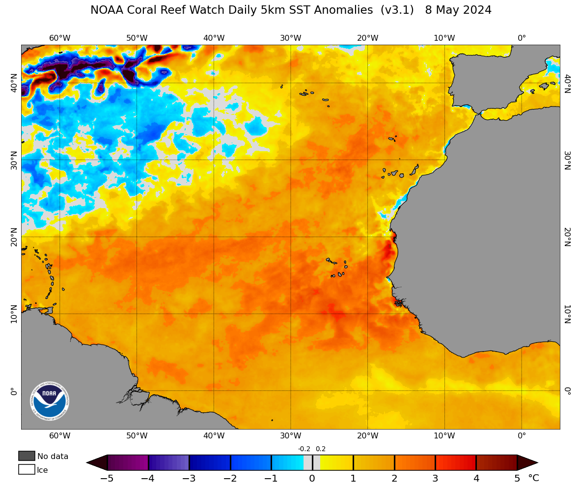
#152 Postby Category5Kaiju » Wed Sep 22, 2021 9:55 am

Image

Whatever happens, future 98L is likely going to have a fun time with this:
6 likes   
Unless explicitly stated, all info in my posts is based on my own opinions and observations. Tropical storms and hurricanes can be extremely dangerous. Do not think you can beat Mother Nature. Refer to an accredited weather research agency or meteorologist if you need to make serious decisions regarding an approaching storm.

User avatar
Hurrilurker
Category 2
Category 2
Posts: 719
Joined: Mon Jun 09, 2003 3:32 pm
Location: San Francisco, CA

Re: ATL: INVEST 98L - Discussion

#153 Postby Hurrilurker » Wed Sep 22, 2021 9:57 am

How is this not already at least a TD? I don't get it.
3 likes   

User avatar
kevin
Category 5
Category 5
Posts: 2554
Age: 26
Joined: Wed Aug 28, 2019 4:35 am

Re: ATL: INVEST 98L - Discussion

#154 Postby kevin » Wed Sep 22, 2021 9:58 am

Hurrilurker wrote:How is this not already at least a TD? I don't get it.


It'll probably be designated as one very soon.
0 likes   

User avatar
aspen
Category 5
Category 5
Posts: 8812
Joined: Sat Oct 12, 2019 7:10 pm
Location: Connecticut, USA

Re: ATL: INVEST 98L - Discussion

#155 Postby aspen » Wed Sep 22, 2021 10:06 am

The 2pm TWO will probably use the “if these trends continue, advisories will be initiated later this afternoon/evening” wording. It’s so close now that I bet it gets designated at 5pm.
4 likes   
Irene '11 Sandy '12 Hermine '16 5/15/2018 Derecho Fay '20 Isaias '20 Elsa '21 Henri '21 Ida '21

I am only a meteorology enthusiast who knows a decent amount about tropical cyclones. Look to the professional mets, the NHC, or your local weather office for the best information.

Sciencerocks
Category 5
Category 5
Posts: 8903
Age: 39
Joined: Thu Jul 06, 2017 1:51 am

Re: ATL: INVEST 98L - Discussion

#156 Postby Sciencerocks » Wed Sep 22, 2021 10:20 am

Image
0 likes   

User avatar
Iceresistance
Category 5
Category 5
Posts: 9279
Age: 21
Joined: Sat Oct 10, 2020 9:45 am
Location: Tecumseh, OK/Norman, OK

Re: ATL: INVEST 98L - Discussion

#157 Postby Iceresistance » Wed Sep 22, 2021 10:20 am

Category5Kaiju wrote:https://coralreefwatch.noaa.gov/data_current/5km/v3.1_op/daily/png/ct5km_ssta_v3.1_nwel_current.png

Whatever happens, future 98L is likely going to have a fun time with this:


Did you mean Future Sam?
0 likes   
Bill 2015 & Beta 2020

Winter 2020-2021 :cold:

All observations are in Tecumseh, OK unless otherwise noted.

Winter posts are focused mainly for Oklahoma & Texas.

Take any of my forecasts with a grain of salt, refer to the NWS, SPC, and NHC for official information

Never say Never with weather! Because ANYTHING is possible!

SconnieCane
Category 4
Category 4
Posts: 997
Joined: Thu Aug 02, 2018 5:29 pm
Location: Madison, WI

Re: ATL: INVEST 98L - Discussion

#158 Postby SconnieCane » Wed Sep 22, 2021 10:22 am

Iceresistance wrote:
Category5Kaiju wrote:https://coralreefwatch.noaa.gov/data_current/5km/v3.1_op/daily/png/ct5km_ssta_v3.1_nwel_current.png

Whatever happens, future 98L is likely going to have a fun time with this:


Did you mean Future Sam?


Is that patch of neutral/slightly negative anomalies Larry's wake? Looks like this should miss that to the south. It needs to be remembered though that in that area of the Atlantic, 0.5 degree C below normal in September is still more than adequate to support a solid tropical cyclone.
0 likes   

grapealcoholic
Category 2
Category 2
Posts: 684
Joined: Tue Aug 10, 2021 3:26 pm

Re: ATL: INVEST 98L - Discussion

#159 Postby grapealcoholic » Wed Sep 22, 2021 10:24 am

You can see some low-level spin around 33W 9N
0 likes   

User avatar
Iceresistance
Category 5
Category 5
Posts: 9279
Age: 21
Joined: Sat Oct 10, 2020 9:45 am
Location: Tecumseh, OK/Norman, OK

Re: ATL: INVEST 98L - Discussion

#160 Postby Iceresistance » Wed Sep 22, 2021 10:25 am

SconnieCane wrote:
Iceresistance wrote:
Category5Kaiju wrote:https://coralreefwatch.noaa.gov/data_current/5km/v3.1_op/daily/png/ct5km_ssta_v3.1_nwel_current.png

Whatever happens, future 98L is likely going to have a fun time with this:


Did you mean Future Sam?


Is that patch of neutral/slightly negative anomalies Larry's wake? Looks like this should miss that to the south. It needs to be remember though that in that area of the Atlantic, 0.5-1 degree C below normal in September is still more than adequate to support a solid tropical cyclone.


Yes, it's Larry's cold water Trail . . .
0 likes   
Bill 2015 & Beta 2020

Winter 2020-2021 :cold:

All observations are in Tecumseh, OK unless otherwise noted.

Winter posts are focused mainly for Oklahoma & Texas.

Take any of my forecasts with a grain of salt, refer to the NWS, SPC, and NHC for official information

Never say Never with weather! Because ANYTHING is possible!


Return to “2021”

Who is online

Users browsing this forum: No registered users and 20 guests