
ATL: SAM - Models
Moderator: S2k Moderators
-
tolakram
- Admin

- Posts: 20186
- Age: 62
- Joined: Sun Aug 27, 2006 8:23 pm
- Location: Florence, KY (name is Mark)
Re: ATL: INVEST 98L - Models
0 likes
M a r k
- - - - -
Join us in chat: Storm2K Chatroom Invite. Android and IOS apps also available.
The posts in this forum are NOT official forecasts and should not be used as such. Posts are NOT endorsed by any professional institution or STORM2K.org. For official information and forecasts, please refer to NHC and NWS products.
-
SouthFLTropics

- Category 5

- Posts: 4258
- Age: 50
- Joined: Thu Aug 14, 2003 8:04 am
- Location: Port St. Lucie, Florida
Re: ATL: INVEST 98L - Models
It's been a while since we had such a dramatic difference of opinion between the two heavyweights. One of them is going to have egg on their face, the only question is will it be the Euro or the GFS.
6 likes
Fourth Generation Florida Native
Personal Storm History: David 79, Andrew 92, Erin 95, Floyd 99, Irene 99, Frances 04, Jeanne 04, Wilma 05, Matthew 16, Irma 17, Ian 22, Nicole 22, Milton 24
Personal Storm History: David 79, Andrew 92, Erin 95, Floyd 99, Irene 99, Frances 04, Jeanne 04, Wilma 05, Matthew 16, Irma 17, Ian 22, Nicole 22, Milton 24
-
tolakram
- Admin
- Posts: 20186
- Age: 62
- Joined: Sun Aug 27, 2006 8:23 pm
- Location: Florence, KY (name is Mark)
Re: ATL: INVEST 98L - Models
AutoPenalti wrote:Maybe the Euro is wrong.
Could be, both models suffer badly in the fall, but the Euro is almost always better than the GFS for upper air patterns. I say almost while not being able to remember a case where the GFS was better.
0 likes
M a r k
- - - - -
Join us in chat: Storm2K Chatroom Invite. Android and IOS apps also available.
The posts in this forum are NOT official forecasts and should not be used as such. Posts are NOT endorsed by any professional institution or STORM2K.org. For official information and forecasts, please refer to NHC and NWS products.
- - - - -
Join us in chat: Storm2K Chatroom Invite. Android and IOS apps also available.
The posts in this forum are NOT official forecasts and should not be used as such. Posts are NOT endorsed by any professional institution or STORM2K.org. For official information and forecasts, please refer to NHC and NWS products.
Re: ATL: INVEST 98L - Models
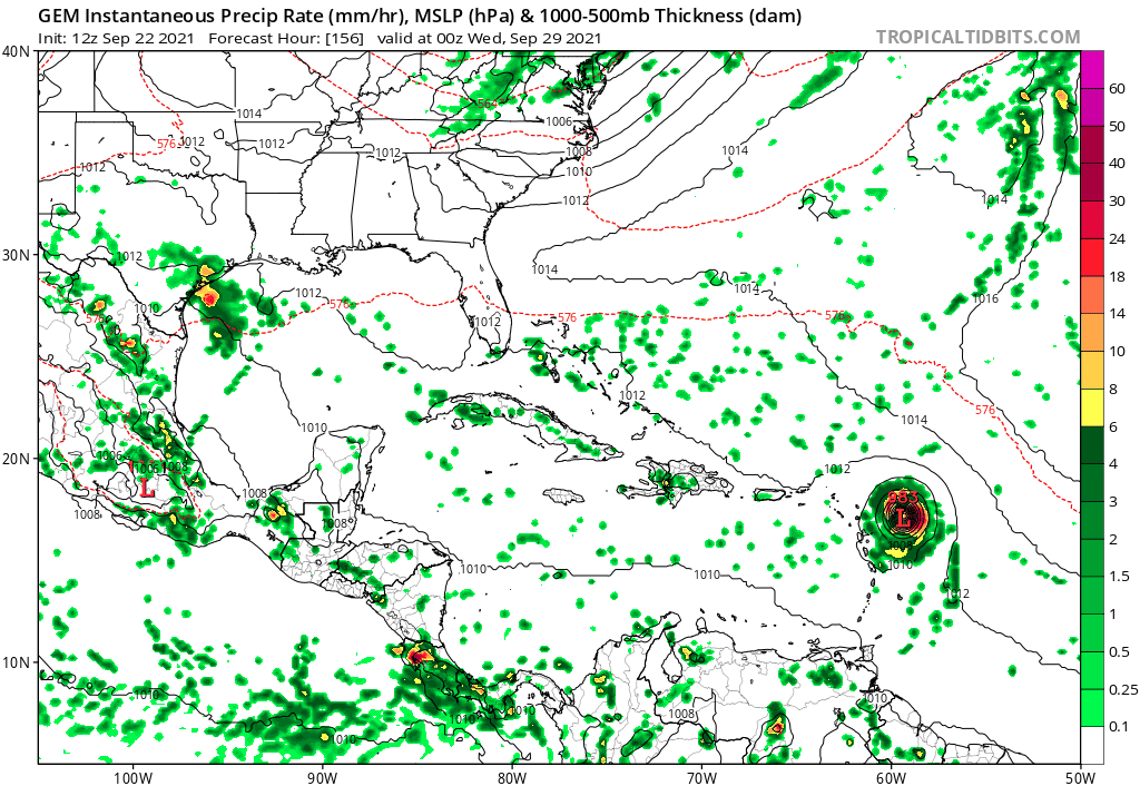
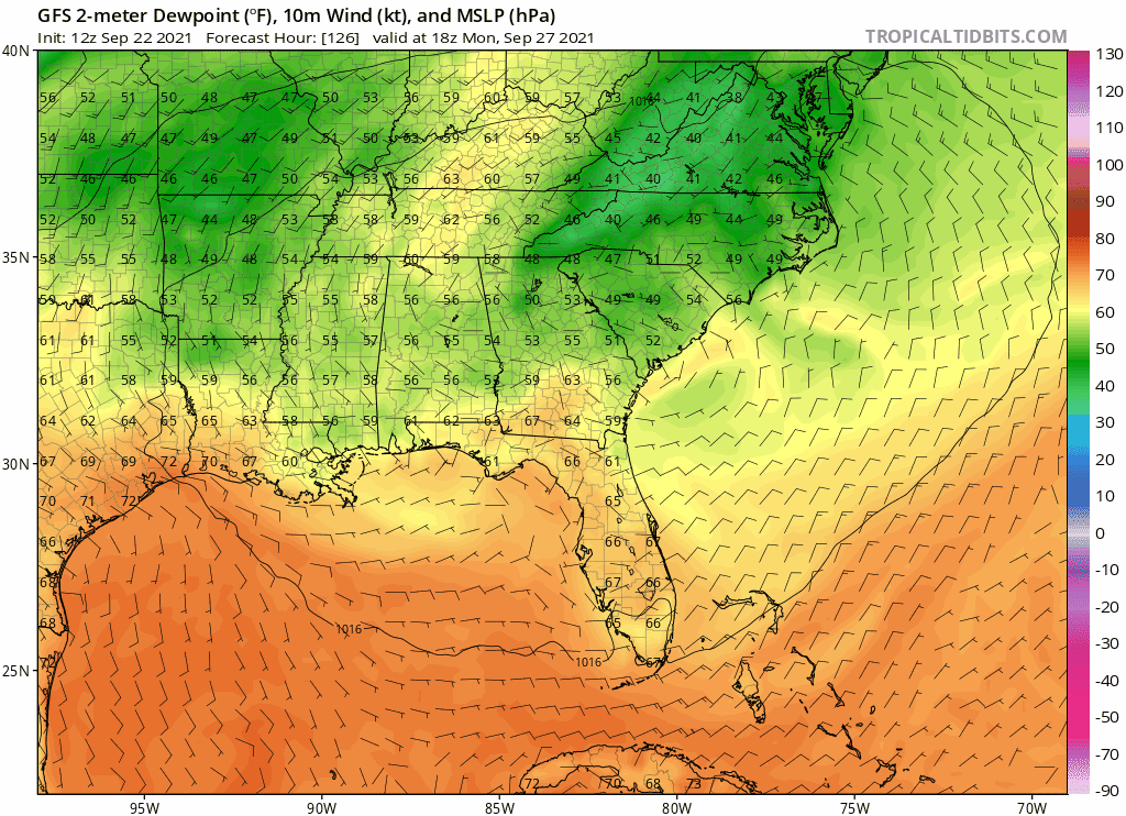
gatorcane wrote:Wow look at those low dew points into South Florida, same trough that could turn future Sam northward. It is a powerful trough to say the least. Won’t be feeling like hurricane weather here if the GFS is right that is fore sure
https://i.postimg.cc/zXDtG9Jc/gfs-Td2m-seus-fh126-174.gif
In what world does the southern tip of Florida get 60 degree dewpoint on Sep 29? Dubious, to say the least
Last edited by sma10 on Wed Sep 22, 2021 11:33 am, edited 1 time in total.
0 likes
-
Blown Away

- S2K Supporter

- Posts: 10253
- Joined: Wed May 26, 2004 6:17 am
Re: ATL: INVEST 98L - Models
The GFS continues showing that persistent L off the CONUS to recurve 98L. I’m not sure it will take 98L 8 days to make it just N of NE Caribbean, that’s where I think the Euro is correct.
1 likes
Hurricane Eye Experience: David 79, Irene 99, Frances 04, Jeanne 04, Wilma 05… Hurricane Brush Experience: Andrew 92, Erin 95, Floyd 99, Matthew 16, Irma 17, Ian 22, Nicole 22…
-
SFLcane

- S2K Supporter
- Posts: 10281
- Age: 48
- Joined: Sat Jun 05, 2010 1:44 pm
- Location: Lake Worth Florida
Re: ATL: INVEST 98L - Models
gatorcane wrote:Wow look at those low dew points into South Florida, same trough that could turn future Sam northward. It is a powerful trough to say the least. Won’t be feeling like hurricane weather here if the GFS is right that is fore sure
https://i.postimg.cc/zXDtG9Jc/gfs-Td2m-seus-fh126-174.gif
Sure, That is highly unlikely in my opinion those dews will never make it that far south. All cooling stays way north near northern Florida. Maybe in a few weeks
0 likes
-
grapealcoholic
- Category 2

- Posts: 703
- Joined: Tue Aug 10, 2021 3:26 pm

Re: ATL: INVEST 98L - Models
The one thing that all the models are in agreement on is that there will be a very strong MDR hurricane (especially for this late period of the MDR season) next week, where it will go is still anyone's guess. I almost always side with the Euro when it and GFS disagree, but since most models are also closer to GFS than the Euro (at least they were this morning) I'm not sure. It's not like the Euro has been faultless this season (far from it). As I mentioned in the discussion thread, these open ocean storms often have a worse-than-normal forecast accuracy since there is less data of the region. Once a recon plane arrives or once it moves west enough I think models will come much more into agreement. Just saying, don't be shocked if in a few days the track moves a few hundred miles further OTS or closer to the islands.
2 likes
-
SFLcane
- S2K Supporter
- Posts: 10281
- Age: 48
- Joined: Sat Jun 05, 2010 1:44 pm
- Location: Lake Worth Florida
Re: ATL: INVEST 98L - Models
Blown Away wrote:The GFS continues showing that persistent L off the CONUS to recurve 98L. I’m not sure it will take 98L 8 days to make it just N of NE Caribbean, that’s where I think the Euro is correct.
Somebody gotta cave soon.
2 likes
Re: ATL: INVEST 98L - Models
Nah, we’re not going to get dues that low until after Halloween.
0 likes
-
grapealcoholic
- Category 2
- Posts: 703
- Joined: Tue Aug 10, 2021 3:26 pm


Re: ATL: INVEST 98L - Models
The CMC so far looks to be the furthest south it has ever been with 98L. This might be another Maria-like run.
4 likes
Irene '11 Sandy '12 Hermine '16 5/15/2018 Derecho Fay '20 Isaias '20 Elsa '21 Henri '21 Ida '21
I am only a meteorology enthusiast who knows a decent amount about tropical cyclones. Look to the professional mets, the NHC, or your local weather office for the best information.
I am only a meteorology enthusiast who knows a decent amount about tropical cyclones. Look to the professional mets, the NHC, or your local weather office for the best information.
-
skyline385

- Category 5
- Posts: 2728
- Age: 35
- Joined: Wed Aug 26, 2020 11:15 pm
- Location: Houston TX
Re: ATL: INVEST 98L - Models
sma10 wrote:gatorcane wrote:Wow look at those low dew points into South Florida, same trough that could turn future Sam northward. It is a powerful trough to say the least. Won’t be feeling like hurricane weather here if the GFS is right that is fore sure
https://i.postimg.cc/zXDtG9Jc/gfs-Td2m-seus-fh126-174.gif
In what world does the southern tip of Florida get 60 degree dewpoint on Sep 29? Dubious, to say the least
Is it that extreme though? The average dew point for SFL in summer is 65-75. 60 isn't too far fetched if a strong trough hits the state?
0 likes
-
gatorcane

- S2K Supporter
- Posts: 23708
- Age: 48
- Joined: Sun Mar 13, 2005 3:54 pm
- Location: Boca Raton, FL
Re: ATL: INVEST 98L - Models
SouthFLTropics wrote:It's been a while since we had such a dramatic difference of opinion between the two heavyweights. One of them is going to have egg on their face, the only question is will it be the Euro or the GFS.
Best bet is still to take the consensus meaning they will likely converge somewhere in the middle
0 likes
Re: ATL: INVEST 98L - Models
Not extreme, but it’s been hot as hades here in central Florida. Hope it comes to pass, but I doubt it. Always sweating on Halloween.
1 likes
-
grapealcoholic
- Category 2
- Posts: 703
- Joined: Tue Aug 10, 2021 3:26 pm
Re: ATL: INVEST 98L - Models
Large SW to NE spread. And now there's a cluster that's pretty far south

0 likes

Re: ATL: INVEST 98L - Models
Big SW shift on the CMC. You can see the ridge just East of if getting stronger with each run.

2 likes
The following post is NOT an official forecast and should not be used as such. It is just the opinion of the poster and may or may not be backed by sound meteorological data. It is NOT endorsed by any professional institution including storm2k.org For Official Information please refer to the NHC and NWS products.
Who is online
Users browsing this forum: No registered users and 22 guests