ATL: SAM - Models
Moderator: S2k Moderators

Re: ATL: INVEST 98L - Models
CMC is splitting the difference which is a good place to be with this uncertainty. Seems resonable.
3 likes
The following post is NOT an official forecast and should not be used as such. It is just the opinion of the poster and may or may not be backed by sound meteorological data. It is NOT endorsed by any professional institution including storm2k.org For Official Information please refer to the NHC and NWS products.

Re: ATL: INVEST 98L - Models
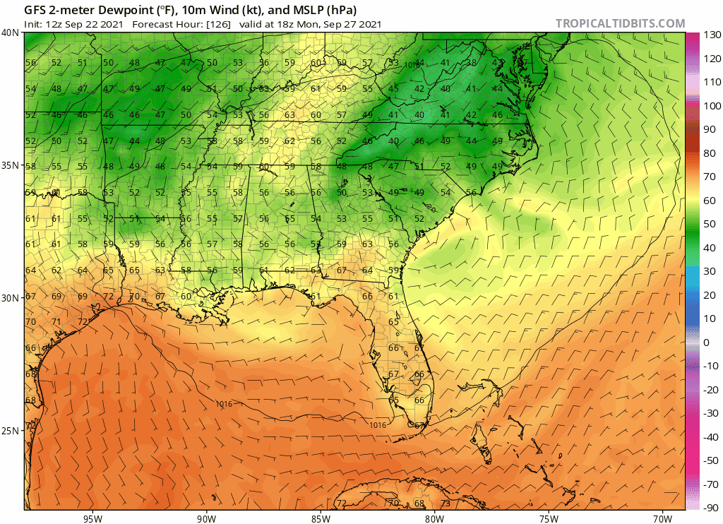
gatorcane wrote:Wow look at those low dew points into South Florida, same trough that could turn future Sam northward. It is a powerful trough to say the least. Won’t be feeling like hurricane weather here if the GFS is right that is fore sure
https://i.postimg.cc/zXDtG9Jc/gfs-Td2m-seus-fh126-174.gif
I remember people always post a GFS run like this in September. Few of them actually verified.
1 likes
TC naming lists: retirements and intensity
Most aggressive Advisory #1's in North Atlantic (cr. kevin for starting the list)
Most aggressive Advisory #1's in North Atlantic (cr. kevin for starting the list)
-
gatorcane

- S2K Supporter

- Posts: 23708
- Age: 48
- Joined: Sun Mar 13, 2005 3:54 pm
- Location: Boca Raton, FL
Re: ATL: INVEST 98L - Models
blp wrote:CMC is splitting the difference which is a good place to be with this uncertainty. Seems resonable.
Close call for the islands:

2 likes
-
Geauxtigers_2019_9
- Tropical Wave

- Posts: 4
- Joined: Tue Sep 21, 2021 2:27 pm
Re: ATL: INVEST 98L - Models
Any reason to believe with the westward trend that this storm can get into the GOM or is that off the table?
0 likes
Re: ATL: INVEST 98L - Models
skyline385 wrote:sma10 wrote:gatorcane wrote:Wow look at those low dew points into South Florida, same trough that could turn future Sam northward. It is a powerful trough to say the least. Won’t be feeling like hurricane weather here if the GFS is right that is fore sure
https://i.postimg.cc/zXDtG9Jc/gfs-Td2m-seus-fh126-174.gif
In what world does the southern tip of Florida get 60 degree dewpoint on Sep 29? Dubious, to say the least
Is it that extreme though? The average dew point for SFL in summer is 65-75. 60 isn't too far fetched if a strong trough hits the state?
I suppose anything is possible. The last time MIA reported a Sept dewpoint of 60 was 2011
1 likes


-
Spacecoast

- Category 2

- Posts: 773
- Joined: Thu Aug 31, 2017 2:03 pm
Re: ATL: INVEST 98L - Models
0z ECMF....after 192 hrs, Operational deviates significantly from the ensemble mean

0 likes
-
grapealcoholic
- Category 2
- Posts: 703
- Joined: Tue Aug 10, 2021 3:26 pm

Re: ATL: INVEST 98L - Models
Spacecoast wrote:0z ECMF....after 192 hrs, Operational deviates significantly from the ensemble mean
https://i.ibb.co/Dk2HCTZ/ecmbs.jpg
There seems to be some kind of a bifurcation point at ~96 hours. Half the members take on a slightly more NW heading, which eventually miss the islands by quite some margin and recurve at 60-65W.
The other half continue on a WNW track like the operational and the CMC, with no recurves until at least 70W. May still recurve and miss the CONUS, but not until it gets dangerously close. This scenario will give the islands a hit or at least a very close miss (Earl 2010 or Jose 2017 are the best analogs).
Now let's see whether that changes on the 12z Euro.
0 likes
TC naming lists: retirements and intensity
Most aggressive Advisory #1's in North Atlantic (cr. kevin for starting the list)
Most aggressive Advisory #1's in North Atlantic (cr. kevin for starting the list)
Re: ATL: INVEST 98L - Models
12z Euro op doubling down? Stronger and a little further SW thru 72 hours compared to 00z
https://www.tropicaltidbits.com/analysi ... 92212&fh=0
https://www.tropicaltidbits.com/analysi ... 92212&fh=0
1 likes
-
grapealcoholic
- Category 2
- Posts: 703
- Joined: Tue Aug 10, 2021 3:26 pm

-
Iceresistance

- Category 5

- Posts: 9592
- Age: 22
- Joined: Sat Oct 10, 2020 9:45 am
- Location: Tecumseh, OK/Norman, OK
Re: ATL: INVEST 98L - Models
12z Euro trending South again . . .
0 likes
Bill 2015 & Beta 2020
Winter 2020-2021
All observations are in Tecumseh, OK unless otherwise noted.
Winter posts are focused mainly for Oklahoma & Texas.
Take any of my forecasts with a grain of salt, refer to the NWS, SPC, and NHC for official information
Never say Never with weather! Because ANYTHING is possible!
Winter 2020-2021
All observations are in Tecumseh, OK unless otherwise noted.
Winter posts are focused mainly for Oklahoma & Texas.
Take any of my forecasts with a grain of salt, refer to the NWS, SPC, and NHC for official information
Never say Never with weather! Because ANYTHING is possible!
-
AutoPenalti
- Category 5
- Posts: 4091
- Age: 29
- Joined: Mon Aug 17, 2015 4:16 pm
- Location: Ft. Lauderdale, Florida
Re: ATL: INVEST 98L - Models
I just want to see the differences at 500mb, this could start south of the equator for all I care.
2 likes
The posts in this forum are NOT official forecasts and should not be used as such. They are just the opinion of the poster and may or may not be backed by sound meteorological data. They are NOT endorsed by any professional institution or STORM2K. For official information, please refer to products from the NHC and NWS.
Model Runs Cheat Sheet:
GFS (5:30 AM/PM, 11:30 AM/PM)
HWRF, GFDL, UKMET, NAVGEM (6:30-8:00 AM/PM, 12:30-2:00 AM/PM)
ECMWF (1:45 AM/PM)
TCVN is a weighted averaged

Re: ATL: INVEST 98L - Models
The Euro to the other models after most of them trend or stay east:

5 likes
-
AutoPenalti
- Category 5
- Posts: 4091
- Age: 29
- Joined: Mon Aug 17, 2015 4:16 pm
- Location: Ft. Lauderdale, Florida
Re: ATL: INVEST 98L - Models
Euro is slightly faster though and the low near Texas seems to be trending faster as well.
0 likes
The posts in this forum are NOT official forecasts and should not be used as such. They are just the opinion of the poster and may or may not be backed by sound meteorological data. They are NOT endorsed by any professional institution or STORM2K. For official information, please refer to products from the NHC and NWS.
Model Runs Cheat Sheet:
GFS (5:30 AM/PM, 11:30 AM/PM)
HWRF, GFDL, UKMET, NAVGEM (6:30-8:00 AM/PM, 12:30-2:00 AM/PM)
ECMWF (1:45 AM/PM)
TCVN is a weighted averaged
Re: ATL: INVEST 98L - Models
AutoPenalti wrote:I just want to see the differences at 500mb, this could start south of the equator for all I care.
Yeah, and it seems the difference at 500mb becomes apparent at 120hr. Euro/CMC still shows some ridging while GFS pretty much evaporates any ridging.
0 likes
-
Hurricaneman

- Category 5
- Posts: 7404
- Age: 45
- Joined: Tue Aug 31, 2004 3:24 pm
- Location: central florida
Re: ATL: INVEST 98L - Models
sma10 wrote:AutoPenalti wrote:I just want to see the differences at 500mb, this could start south of the equator for all I care.
Yeah, and it seems the difference at 500mb becomes apparent at 120hr. Euro/CMC still shows some ridging while GFS pretty much evaporates any ridging.
It’s the GFS bias of breaking down ridges
2 likes
Re: ATL: INVEST 98L - Models
Hurricaneman wrote:sma10 wrote:AutoPenalti wrote:I just want to see the differences at 500mb, this could start south of the equator for all I care.
Yeah, and it seems the difference at 500mb becomes apparent at 120hr. Euro/CMC still shows some ridging while GFS pretty much evaporates any ridging.
It’s the GFS bias of breaking down ridges
We'll see tho. At 144hr, Euro now is a smidge North from yesterday run, in response to a deeper digging trough. Will have to see how progressive that trough is.
0 likes

Re: ATL: INVEST 98L - Models
The HWRF now seems to be on the NE side of the model guidance. 98L is already around 17-18N by the end of the run (2+ degrees north of the HMON at the same time frame), and it might be going over Larry’s cold wake. This track will spare all land masses from hurricane conditions but potentially limit intensity and therefore ACE; an HMON-like track could allow for a stronger storm that’ll still miss the Lesser Antilles and Bermuda.
The HWRF is either on the SW extreme or the NE extreme with track, it seems.
The HWRF is either on the SW extreme or the NE extreme with track, it seems.
Last edited by aspen on Wed Sep 22, 2021 1:37 pm, edited 1 time in total.
0 likes
Irene '11 Sandy '12 Hermine '16 5/15/2018 Derecho Fay '20 Isaias '20 Elsa '21 Henri '21 Ida '21
I am only a meteorology enthusiast who knows a decent amount about tropical cyclones. Look to the professional mets, the NHC, or your local weather office for the best information.
I am only a meteorology enthusiast who knows a decent amount about tropical cyclones. Look to the professional mets, the NHC, or your local weather office for the best information.
Re: ATL: INVEST 98L - Models
12z Euro further N vs 0Z. Less ridging. Looking better for CONUS this run.
0 likes
Personal Forecast Disclaimer:
The posts in this forum are NOT official forecasts and should not be used as such. They are just the opinion of the poster and may or may not be backed by sound meteorological data. They are NOT endorsed by any professional institution or storm2k.org. For official information, please refer to the NHC and NWS products.
The posts in this forum are NOT official forecasts and should not be used as such. They are just the opinion of the poster and may or may not be backed by sound meteorological data. They are NOT endorsed by any professional institution or storm2k.org. For official information, please refer to the NHC and NWS products.
Who is online
Users browsing this forum: No registered users and 19 guests