ATL: SAM - Models
Moderator: S2k Moderators
-
AubreyStorm

- Category 1

- Posts: 337
- Age: 45
- Joined: Fri Jun 16, 2017 6:21 pm
- Location: Texas, USA
Re: ATL: SAM - Models
No way
Last edited by AubreyStorm on Fri Sep 24, 2021 9:44 am, edited 2 times in total.
2 likes
The posts are NOT an official forecast. Please REFER to the NHC and NWS for official forecasts and products.
-
gatorcane

- S2K Supporter

- Posts: 23708
- Age: 48
- Joined: Sun Mar 13, 2005 3:54 pm
- Location: Boca Raton, FL
Re: ATL: SAM - Models
AutoPenalti wrote:There's roughly 5-7 days before we even figure out where this will be so A LOT can change.
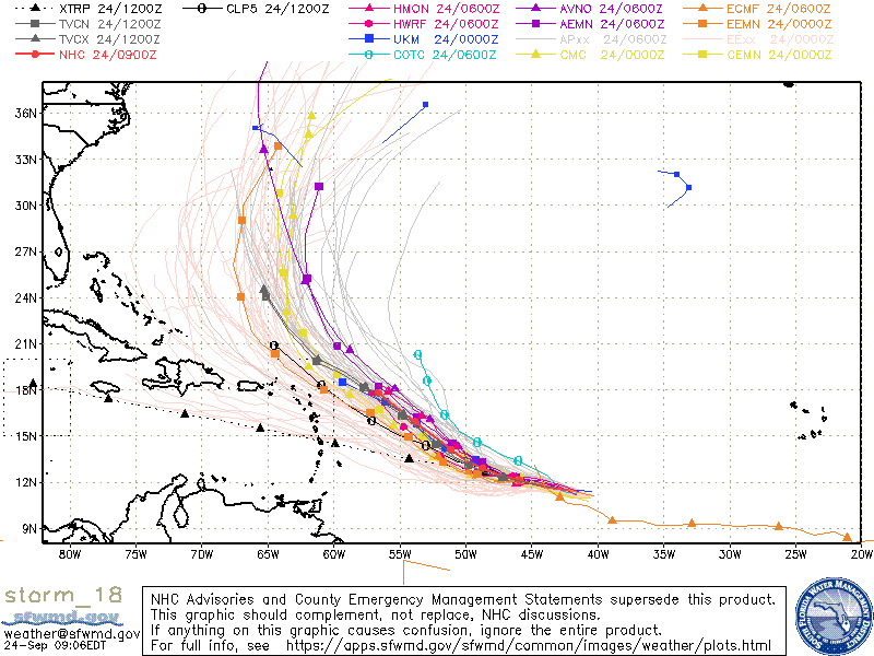
Yes they can change but at least the model spaghetti strongly suggests a recurve and I think it is clear the Euro has been way too west-biased until the last run. Islands and Bermuda should watch though:
1 likes
-
gatorcane
- S2K Supporter
- Posts: 23708
- Age: 48
- Joined: Sun Mar 13, 2005 3:54 pm
- Location: Boca Raton, FL
Re: ATL: SAM - Models
The 06Z GFS brings a powerful Sam over Bermuda, fortunately the island is tiny so likely will not end up like that.
0 likes
Re: ATL: SAM - Models
AutoPenalti wrote:There's roughly 5-7 days before we even figure out where this will be so A LOT can change.
Of course a recurve is the most likely outcome, but in a way this reminds me of whenever the reverse scenario exists: a storm is in the central Atlantic 6-8 days from CONUS and the models all show a strong high with various solutions - does it go below or above Hisp? Does it make it all the way into the Gulf? And the posts say "someone is getting this one for sure" and "absolutely zero chance of this avoiding the US".
And then, lo and behold ...
Just saying, things do change occasionally
2 likes

Re: ATL: SAM - Models
sma10 wrote:AutoPenalti wrote:There's roughly 5-7 days before we even figure out where this will be so A LOT can change.
Of course a recurve is the most likely outcome, but in a way this reminds me of whenever the reverse scenario exists: a storm is in the central Atlantic 6-8 days from CONUS and the models all show a strong high with various solutions - does it go below or above Hisp? Does it make it all the way into the Gulf? And the posts say "someone is getting this one for sure" and "absolutely zero chance of this avoiding the US".
And then, lo and behold ...
Just saying, things do change occasionally
This was exactly what happened with Laura, Fred and maybe even Grace. I remember people writing lengthy posts saying these storms will definitely go OTS. Just saying.
1 likes
TC naming lists: retirements and intensity
Most aggressive Advisory #1's in North Atlantic (cr. kevin for starting the list)
Most aggressive Advisory #1's in North Atlantic (cr. kevin for starting the list)
-
Spacecoast

- Category 2

- Posts: 773
- Joined: Thu Aug 31, 2017 2:03 pm
Re: ATL: SAM - Models
NHC 11:00....
24H 25/1200Z 12.3N 47.1W 90 KT 105 MPH
36H 26/0000Z 12.7N 48.4W 105 KT 120 MPH
48H 26/1200Z 13.1N 49.7W 115 KT 130 MPH
60H 27/0000Z 13.7N 50.9W 115 KT 130 MPH
72H 27/1200Z 14.6N 52.1W 115 KT 130 MPH
96H 28/1200Z 16.4N 54.8W 110 KT 125 MPH
120H 29/1200Z 18.2N 57.7W 110 KT 125 MPH
For reference, I placed a small black square @ NHC 5 day point, along w/ pink (hard to see) line from 96 hr point, on latest ensembles:
NHC seems to favor GEFS mean over ECENS mean atm....
4 likes
-
Spacecoast
- Category 2
- Posts: 773
- Joined: Thu Aug 31, 2017 2:03 pm
ATL: SAM - Hurricane - Discussion
Latest multi model plot (12z from 6z runs)
ECMF still lagging in intensity? why so different?

ECMF still lagging in intensity? why so different?
0 likes


Re: ATL: SAM - Models
0 likes
-
Category5Kaiju

- Category 5

- Posts: 4334
- Joined: Thu Dec 24, 2020 12:45 pm
- Location: Seattle and Phoenix
Re: ATL: SAM - Models
Did the last GFS run just do what I thought it did?
0 likes
Unless explicitly stated, all info in my posts is based on my own opinions and observations. Tropical storms and hurricanes can be extremely dangerous. Refer to an accredited weather research agency or meteorologist if you need to make serious decisions regarding an approaching storm.
-
Iceresistance

- Category 5
- Posts: 9592
- Age: 22
- Joined: Sat Oct 10, 2020 9:45 am
- Location: Tecumseh, OK/Norman, OK
Re: ATL: SAM - Models
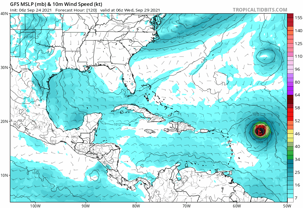
12z CMC is very concerning as a 971 MB Hurricane Landfall over New Hampshire/Maine . . .
0 likes
Bill 2015 & Beta 2020
Winter 2020-2021
All observations are in Tecumseh, OK unless otherwise noted.
Winter posts are focused mainly for Oklahoma & Texas.
Take any of my forecasts with a grain of salt, refer to the NWS, SPC, and NHC for official information
Never say Never with weather! Because ANYTHING is possible!
Winter 2020-2021
All observations are in Tecumseh, OK unless otherwise noted.
Winter posts are focused mainly for Oklahoma & Texas.
Take any of my forecasts with a grain of salt, refer to the NWS, SPC, and NHC for official information
Never say Never with weather! Because ANYTHING is possible!
-
ColdMiser123

- Professional-Met

- Posts: 905
- Age: 29
- Joined: Mon Sep 26, 2016 3:26 pm
- Location: Northeast US
Re: ATL: SAM - Models
Iceresistance wrote:12z CMC is very concerning as a 971 MB Hurricane Landfall over New Hampshire/Maine . . .
That is the risk to the Northeast with that set-up. It's low, but it's there.
It's low because you need to get a cutoff low of around a certain strength in order for that solution to verify. Can't be too weak, or it won't be able to bring the storm in. Can't be too strong either though, or it will shear Sam apart.
Ridge to the Northeast also needs to be substantial so that Sam doesn't drift too far east and miss the phase. There's a lot that needs to come together for that solution to happen.
2 likes
B.S., M.S., Meteorology & Atmospheric Science

Re: ATL: SAM - Models
Hey Everyone, new member here. Have really enjoyed following this storm. I am by no means an expert, but I am trying to learn. On another note, I live in Broward County (SE Florida). Would you say that we are 100% in the clear?
1 likes
-
skyline385

- Category 5
- Posts: 2728
- Age: 35
- Joined: Wed Aug 26, 2020 11:15 pm
- Location: Houston TX
Re: ATL: SAM - Models
jets42689 wrote:Hey Everyone, new member here. Have really enjoyed following this storm. I am by no means an expert, but I am trying to learn. On another note, I live in Broward County (SE Florida). Would you say that we are 100% in the clear?
Not even the NHC will say that you are 100% in the clear, however it is pretty unlikely at the moment that it impacts SFL. We have yet to see a single run with a Florida landfall and there aren't any ensembles hinting at that either.
0 likes
-
AutoPenalti
- Category 5
- Posts: 4091
- Age: 29
- Joined: Mon Aug 17, 2015 4:16 pm
- Location: Ft. Lauderdale, Florida
Re: ATL: SAM - Models
jets42689 wrote:Hey Everyone, new member here. Have really enjoyed following this storm. I am by no means an expert, but I am trying to learn. On another note, I live in Broward County (SE Florida). Would you say that we are 100% in the clear?
It’s something to watch, nothing concrete with a forecast that’s >7 days out
0 likes
The posts in this forum are NOT official forecasts and should not be used as such. They are just the opinion of the poster and may or may not be backed by sound meteorological data. They are NOT endorsed by any professional institution or STORM2K. For official information, please refer to products from the NHC and NWS.
Model Runs Cheat Sheet:
GFS (5:30 AM/PM, 11:30 AM/PM)
HWRF, GFDL, UKMET, NAVGEM (6:30-8:00 AM/PM, 12:30-2:00 AM/PM)
ECMWF (1:45 AM/PM)
TCVN is a weighted averaged
Re: ATL: SAM - Models
skyline385 wrote:jets42689 wrote:Hey Everyone, new member here. Have really enjoyed following this storm. I am by no means an expert, but I am trying to learn. On another note, I live in Broward County (SE Florida). Would you say that we are 100% in the clear?
Not even the NHC will say that you are 100% in the clear, however it is pretty unlikely at the moment that it impacts SFL. We have yet to see a single run with a Florida landfall and there aren't any ensembles hinting at that either.
Can you recall any instance of a hurricane taking a track that is well outside of all ensembles 7+ days out? I was looking up Andrew to see what the very early ensembles called for, but I can't find anything.
0 likes
Re: ATL: SAM - Models
I think the CMC does a better job than the GFS, the upper low spawning a coastal off Cape May while a hurricane is going by isn't going to happen.
2 likes

Re: ATL: SAM - Models
Category5Kaiju wrote:Did the last GFS run just do what I thought it did?
Been pretty consistent goin fishin with Sam...but the anomalous tropical storm it develops off the Del Marva also looks fishy to me.
0 likes
Re: ATL: SAM - Models
jets42689 wrote:skyline385 wrote:jets42689 wrote:Hey Everyone, new member here. Have really enjoyed following this storm. I am by no means an expert, but I am trying to learn. On another note, I live in Broward County (SE Florida). Would you say that we are 100% in the clear?
Not even the NHC will say that you are 100% in the clear, however it is pretty unlikely at the moment that it impacts SFL. We have yet to see a single run with a Florida landfall and there aren't any ensembles hinting at that either.
Can you recall any instance of a hurricane taking a track that is well outside of all ensembles 7+ days out? I was looking up Andrew to see what the very early ensembles called for, but I can't find anything.
Matthew 2016???...
1 likes
Who is online
Users browsing this forum: No registered users and 25 guests