DioBrando wrote:Hypercane_Kyle wrote:Sam ranking very highly up there with other powerful MDR storms this evening. My 135 knot, MSLP 945mb guess is looking good.
Like which ones you reckon?
Jose 2017, Hugo 1988, Igor 2010, and others.
Moderator: S2k Moderators


DioBrando wrote:Hypercane_Kyle wrote:Sam ranking very highly up there with other powerful MDR storms this evening. My 135 knot, MSLP 945mb guess is looking good.
Like which ones you reckon?
Teban54 wrote:On one hand the IR presentation really took a beating, on the other hand there's still intense lightning in the eyewall and pressure hasn't changed much. I don't know what's going on here...
If there was indeed a weakening from the 5pm advisory time (when Sam looked the best IMO) to when recon arrived, one might be able to argue that Sam was a Cat 5 earlier, but the assumed weakening is not a given.

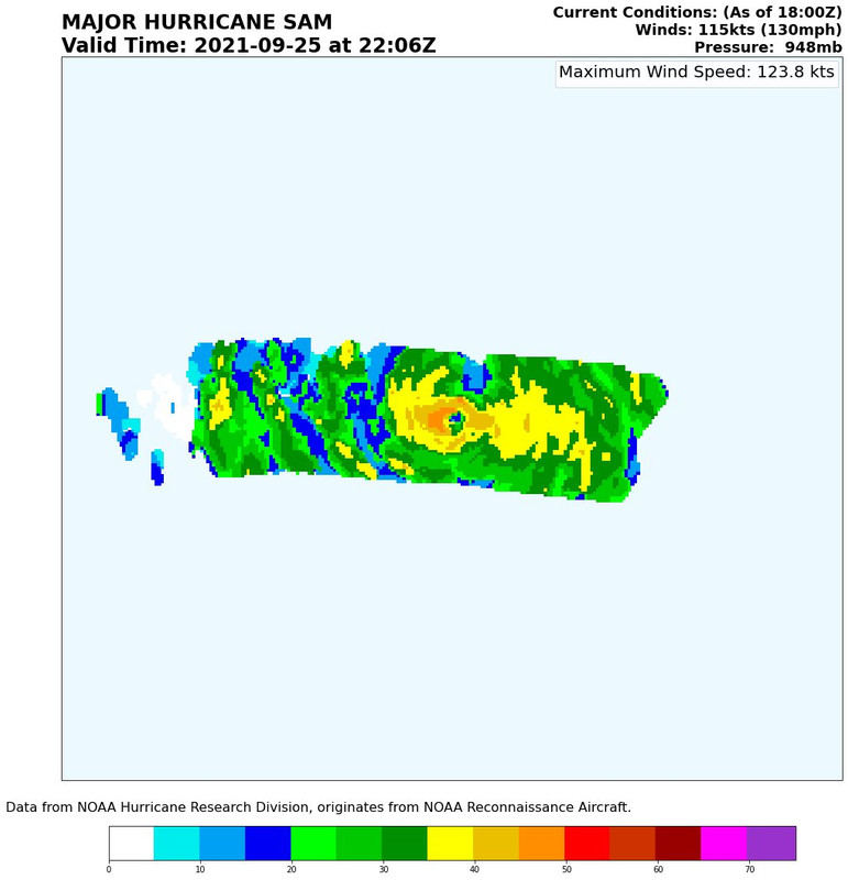
GCANE wrote:Last eye drop recorded 43% RH at 700mb.
Good indication an EWRC maybe forthcoming.

Hypercane_Kyle wrote:DioBrando wrote:Hypercane_Kyle wrote:Sam ranking very highly up there with other powerful MDR storms this evening. My 135 knot, MSLP 945mb guess is looking good.
Like which ones you reckon?
Jose 2017, Hugo 1988, Igor 2010, and others.
GCANE wrote:Last eye drop recorded 43% RH at 700mb.
Good indication an EWRC maybe forthcoming.


WiscoWx02 wrote:Yellow Evan wrote:Ok storm seems to be becoming less symmetrical and cloud top warmth is now persisting. A weakening trend is now imminent though not sure what’s causing it.
I smell an eye wall replacement cycle. Weakening for sure. Will have to see if it can finish this eye wall replacement cycle without pulling a Larry. Actually, does anyone know where the best place to access microwave scans of storm structure are?

Yellow Evan wrote:WiscoWx02 wrote:Yellow Evan wrote:Ok storm seems to be becoming less symmetrical and cloud top warmth is now persisting. A weakening trend is now imminent though not sure what’s causing it.
I smell an eye wall replacement cycle. Weakening for sure. Will have to see if it can finish this eye wall replacement cycle without pulling a Larry. Actually, does anyone know where the best place to access microwave scans of storm structure are?
There’s no sign of an outer eyewall on recon.

aspen wrote:No special advisory so far…they should really do one before observations no longer support 130 kt.
aspen wrote:Pressure steady, SFMR up to 140 kt. Sam is either 130 or 135 kt.
Users browsing this forum: No registered users and 18 guests