ATL: SAM - Remnants - Discussion

Moderator: S2k Moderators

Message
Author
ChrisH-UK
Category 2
Category 2
Posts: 625
Joined: Sat May 29, 2021 8:22 am

Re: ATL: SAM - Hurricane - Discussion

#1101 Postby ChrisH-UK » Sun Sep 26, 2021 5:17 am

Sun rise on Sam.

GOES-16 Red band + CIRA Snow/Cloud Source - https://col.st/tbNK0


GOES-16 Red Band + Cloud Top Phase https://col.st/Vri8V

6 likes   

User avatar
aspen
Category 5
Category 5
Posts: 8818
Joined: Sat Oct 12, 2019 7:10 pm
Location: Connecticut, USA

Re: ATL: SAM - Hurricane - Discussion

#1102 Postby aspen » Sun Sep 26, 2021 5:34 am

Really? They went 5-10kt below recon estimates and then rescheduled the second recon flight until late this afternoon? Very, very disappointing. Odds are an EWRC will begin before recon arrives.

Edit: found the 11pm discussion. Once again, they’re sus of SFMR, but pointed out the absurdly high dropsondes and the possibility of very strong mesovorts, and said the pressure supports 125 kt with wind-pressure relationships.
5 likes   
Irene '11 Sandy '12 Hermine '16 5/15/2018 Derecho Fay '20 Isaias '20 Elsa '21 Henri '21 Ida '21

I am only a meteorology enthusiast who knows a decent amount about tropical cyclones. Look to the professional mets, the NHC, or your local weather office for the best information.

grapealcoholic
Category 2
Category 2
Posts: 684
Joined: Tue Aug 10, 2021 3:26 pm

Re: ATL: SAM - Hurricane - Discussion

#1103 Postby grapealcoholic » Sun Sep 26, 2021 5:47 am


This is absurd structure; looks like a WPAC storm
1 likes   

User avatar
kevin
Category 5
Category 5
Posts: 2586
Age: 26
Joined: Wed Aug 28, 2019 4:35 am

Re: ATL: SAM - Hurricane - Discussion

#1104 Postby kevin » Sun Sep 26, 2021 5:54 am

Just gorgeous:

Image
8 likes   

User avatar
aspen
Category 5
Category 5
Posts: 8818
Joined: Sat Oct 12, 2019 7:10 pm
Location: Connecticut, USA

Re: ATL: SAM - Hurricane - Discussion

#1105 Postby aspen » Sun Sep 26, 2021 6:04 am

kevin wrote:Just gorgeous:

https://i.imgur.com/LuCoDOY.jpg

If it wasn’t 130 kt earlier, it is now. Sam has kept that full W ring for quite a while now.

Fingers crossed the mid-level dry air is of just the right quantity to kill off the outer bands and postpone an EWRC, without damaging the core itself.
0 likes   
Irene '11 Sandy '12 Hermine '16 5/15/2018 Derecho Fay '20 Isaias '20 Elsa '21 Henri '21 Ida '21

I am only a meteorology enthusiast who knows a decent amount about tropical cyclones. Look to the professional mets, the NHC, or your local weather office for the best information.

User avatar
NDG
S2K Supporter
S2K Supporter
Posts: 15446
Joined: Sun Jul 09, 2006 10:14 pm
Location: Orlando, FL

Re: ATL: SAM - Hurricane - Discussion

#1106 Postby NDG » Sun Sep 26, 2021 6:10 am

Another picture of such a good looking MH.

Image
8 likes   

Chemmers
Tropical Storm
Tropical Storm
Posts: 220
Joined: Wed Jul 22, 2020 6:16 am

Re: ATL: SAM - Hurricane - Discussion

#1107 Postby Chemmers » Sun Sep 26, 2021 6:27 am

Look like in the last few hours it has almost been heading due west, hopefully it won’t continue
3 likes   

User avatar
aspen
Category 5
Category 5
Posts: 8818
Joined: Sat Oct 12, 2019 7:10 pm
Location: Connecticut, USA

Re: ATL: SAM - Hurricane - Discussion

#1108 Postby aspen » Sun Sep 26, 2021 6:45 am

The small eye has resulted in satellite estimates decreasing. I hope the NHC doesn’t drop this to 120 kt as a result, because when looking at Dvorak imagery, it’s still a T#6.5-6.7 — a complete W ring with an eye that has sometimes reached WMG but remains above 10C. Also, it’s overall structure and core symmetry has improved since last night.
0 likes   
Irene '11 Sandy '12 Hermine '16 5/15/2018 Derecho Fay '20 Isaias '20 Elsa '21 Henri '21 Ida '21

I am only a meteorology enthusiast who knows a decent amount about tropical cyclones. Look to the professional mets, the NHC, or your local weather office for the best information.

User avatar
Owasso
Category 1
Category 1
Posts: 309
Joined: Sat Aug 22, 2020 11:14 pm
Location: Chicago, Illinois

Re: ATL: SAM - Hurricane - Discussion

#1109 Postby Owasso » Sun Sep 26, 2021 6:52 am

TXNT24 KNES 261137
TCSNTL

A. 18L (SAM)

B. 26/1131Z

C. 13.8N

D. 50.0W

E. ONE/GOES-E

F. T6.5/6.5

G. IR/EIR/VIS

H. REMARKS...A WMG EYE SURROUNDED BY WHITE AND EMBEDDED IN BLACK YIELDS A
DT OF 6.5 AFTER AN EYE ADJ OG +1.0. MET IS EQUAL TO 6.5 AND PT IS EQUAL TO
6.0 BASED ON A DEVELOPMENT TREND IN THE LAST 24 HOURS. FT IS BASED ON DT.

I. ADDL POSITIONS

NIL


...TUGGLE
0 likes   

User avatar
Extratropical94
Professional-Met
Professional-Met
Posts: 3538
Age: 30
Joined: Wed Oct 20, 2010 6:36 am
Location: Hamburg, Germany
Contact:

Re: ATL: SAM - Hurricane - Discussion

#1110 Postby Extratropical94 » Sun Sep 26, 2021 6:54 am

Crossing 50W at about 13.9N

Image
0 likes   
54° 11' 59'' N, 9° 9' 20'' E
Boomer Sooner!
Go Broncos! Go Cards! Go Niners!
- Daniel

User avatar
NDG
S2K Supporter
S2K Supporter
Posts: 15446
Joined: Sun Jul 09, 2006 10:14 pm
Location: Orlando, FL

Re: ATL: SAM - Hurricane - Discussion

#1111 Postby NDG » Sun Sep 26, 2021 6:59 am

The impressive lightning show along the western eyewall continues. Recon even reported grauple at 10k feet on last night's mission.

Image
8 likes   

User avatar
Fishing
S2K Supporter
S2K Supporter
Posts: 67
Age: 65
Joined: Thu Sep 03, 2015 11:53 am
Location: Mount Pleasant, SC

Re: ATL: SAM - Hurricane - Discussion

#1112 Postby Fishing » Sun Sep 26, 2021 7:01 am

Chemmers wrote:Look like in the last few hours it has almost been heading due west, hopefully it won’t continue

It almost looks like it’s gone stationary or just barely moving? The insight has changed over the years but is it still the norm that when stationary it’s next move is a direction change?


Sent from my iPhone using Tapatalk
1 likes   

User avatar
aspen
Category 5
Category 5
Posts: 8818
Joined: Sat Oct 12, 2019 7:10 pm
Location: Connecticut, USA

Re: ATL: SAM - Hurricane - Discussion

#1113 Postby aspen » Sun Sep 26, 2021 7:08 am

I’d go with 130kt/941mb for 12z. The NHC is clearly skeptical of last night’s SFMR readings, but given this morning’s improvement in overall structure and the burst in eyewall lightning, it can be reasoned that Sam has gotten a little stronger.
0 likes   
Irene '11 Sandy '12 Hermine '16 5/15/2018 Derecho Fay '20 Isaias '20 Elsa '21 Henri '21 Ida '21

I am only a meteorology enthusiast who knows a decent amount about tropical cyclones. Look to the professional mets, the NHC, or your local weather office for the best information.

User avatar
cycloneye
Admin
Admin
Posts: 145359
Age: 68
Joined: Thu Oct 10, 2002 10:54 am
Location: San Juan, Puerto Rico

Re: ATL: SAM - Hurricane - Discussion

#1114 Postby cycloneye » Sun Sep 26, 2021 7:22 am

I wonder why this gap between the mission last night and the 4 PM one this afternoon. Very vaulable time in this period that Sam is getting a little stronger this morning.
0 likes   
Visit the Caribbean-Central America Weather Thread where you can find at first post web cams,radars
and observations from Caribbean basin members Click Here

User avatar
cycloneye
Admin
Admin
Posts: 145359
Age: 68
Joined: Thu Oct 10, 2002 10:54 am
Location: San Juan, Puerto Rico

Re: ATL: SAM - Hurricane - Discussion

#1115 Postby cycloneye » Sun Sep 26, 2021 7:24 am

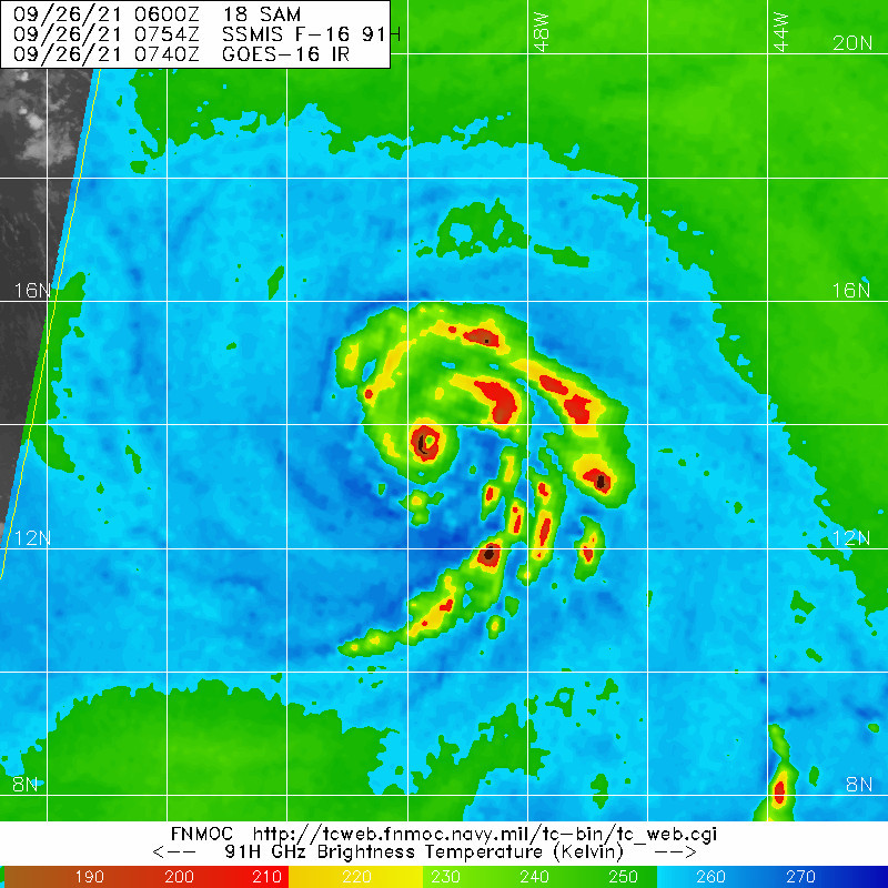
NDG wrote:The impressive lightning show along the western eyewall continues. Recon even reported grauple at 10k feet on last night's mission.

https://i.imgur.com/Set5RXs.gif


Do you have the link to this image?
0 likes   
Visit the Caribbean-Central America Weather Thread where you can find at first post web cams,radars
and observations from Caribbean basin members Click Here

User avatar
Iceresistance
Category 5
Category 5
Posts: 9288
Age: 21
Joined: Sat Oct 10, 2020 9:45 am
Location: Tecumseh, OK/Norman, OK

Re: ATL: SAM - Hurricane - Discussion

#1116 Postby Iceresistance » Sun Sep 26, 2021 7:27 am

Sam is moving more west now on Satellite . . .
1 likes   
Bill 2015 & Beta 2020

Winter 2020-2021 :cold:

All observations are in Tecumseh, OK unless otherwise noted.

Winter posts are focused mainly for Oklahoma & Texas.

Take any of my forecasts with a grain of salt, refer to the NWS, SPC, and NHC for official information

Never say Never with weather! Because ANYTHING is possible!

User avatar
Extratropical94
Professional-Met
Professional-Met
Posts: 3538
Age: 30
Joined: Wed Oct 20, 2010 6:36 am
Location: Hamburg, Germany
Contact:

Re: ATL: SAM - Hurricane - Discussion

#1117 Postby Extratropical94 » Sun Sep 26, 2021 7:32 am

Still 125/943

AL, 18, 2021092612, , BEST, 0, 138N, 500W, 125, 943, HU, 34, NEQ, 80, 80, 40, 60, 1013, 120, 10, 0, 0, L, 0, , 0, 0, SAM, D, 0, , 0, 0, 0, 0, genesis-num, 038,
AL, 18, 2021092612, , BEST, 0, 138N, 500W, 125, 943, HU, 50, NEQ, 40, 30, 20, 30, 1013, 120, 10, 0, 0, L, 0, , 0, 0, SAM, D, 0, , 0, 0, 0, 0, genesis-num, 038,
AL, 18, 2021092612, , BEST, 0, 138N, 500W, 125, 943, HU, 64, NEQ, 25, 20, 15, 20, 1013, 120, 10, 0, 0, L, 0, , 0, 0, SAM, D, 0, , 0, 0, 0, 0, genesis-num, 038,
0 likes   
54° 11' 59'' N, 9° 9' 20'' E
Boomer Sooner!
Go Broncos! Go Cards! Go Niners!
- Daniel

User avatar
aspen
Category 5
Category 5
Posts: 8818
Joined: Sat Oct 12, 2019 7:10 pm
Location: Connecticut, USA

Re: ATL: SAM - Hurricane - Discussion

#1118 Postby aspen » Sun Sep 26, 2021 7:34 am

12z BT is still 125 kt…it’s almost as if the NHC doesn’t want to go above 125 kt, between this and recon being moved until tonight when an EWRC will almost certainly be starting. At least, I assume an EWRC will start before then; Dorian’s refusal to have one was abnormal and I doubt Sam will follow suit.

Sam will surpass 10 ACE once the 11am advisory comes out.
0 likes   
Irene '11 Sandy '12 Hermine '16 5/15/2018 Derecho Fay '20 Isaias '20 Elsa '21 Henri '21 Ida '21

I am only a meteorology enthusiast who knows a decent amount about tropical cyclones. Look to the professional mets, the NHC, or your local weather office for the best information.

User avatar
kevin
Category 5
Category 5
Posts: 2586
Age: 26
Joined: Wed Aug 28, 2019 4:35 am

Re: ATL: SAM - Hurricane - Discussion

#1119 Postby kevin » Sun Sep 26, 2021 7:34 am

Sam's eye has further contracted over the last few hours to roughly 6 miles (9 km) based on IR, which definitely fits the pinhole eye description. Contraction seems to have stopped now as Sam is further solidifying its structure and the eye is drying out again. I think that during re-analysis this will definitely be upped to 130 kt instead of 125 kt if NHC follows best track for now. All we can do is hope that it maintains this presentation until recon arrives around 20z.

Image
1 likes   

User avatar
Iceresistance
Category 5
Category 5
Posts: 9288
Age: 21
Joined: Sat Oct 10, 2020 9:45 am
Location: Tecumseh, OK/Norman, OK

Re: ATL: SAM - Hurricane - Discussion

#1120 Postby Iceresistance » Sun Sep 26, 2021 7:38 am

Has Recon ever made an emergency go into the storm because of it's impressive structure?
0 likes   
Bill 2015 & Beta 2020

Winter 2020-2021 :cold:

All observations are in Tecumseh, OK unless otherwise noted.

Winter posts are focused mainly for Oklahoma & Texas.

Take any of my forecasts with a grain of salt, refer to the NWS, SPC, and NHC for official information

Never say Never with weather! Because ANYTHING is possible!


Return to “2021”

Who is online

Users browsing this forum: No registered users and 2 guests