
WPAC: MINDULLE - Post-Tropical
Moderator: S2k Moderators
-
mrbagyo

- Category 5

- Posts: 3963
- Age: 33
- Joined: Thu Apr 12, 2012 9:18 am
- Location: 14.13N 120.98E
- Contact:
Re: WPAC: MINDULLE - Typhoon
0 likes
The posts in this forum are NOT official forecast and should not be used as such. They are just the opinion of the poster and may or may not be backed by sound meteorological data. They are NOT endorsed by any professional institution or storm2k.org. For official information, please refer to RSMC, NHC and NWS products.

Re: WPAC: MINDULLE - Typhoon
SMAP got (an almost) 09Z fix, and it's 134 knots in 1 min
WP, 20, 202109260858, 30, SMAP, IR, , 1880N, 13670E, , 1, 125, 1, , , , 34, NEQ, 0, 0, 115, 171, , , , , 1, 0, , W, NASA, RSS, , , , , , , , , , , , , , , , , , , , , , , , , , , , 1, max. wind is 10 minute sustained
WP, 20, 202109260858, 30, SMAP, IR, , 1880N, 13670E, , 1, 125, 1, , , , 50, NEQ, 0, 0, 70, 83, , , , , 1, 0, , W, NASA, RSS, , , , , , , , , , , , , , , , , , , , , , , , , , , , 1, max. wind is 10 minute sustained
WP, 20, 202109260858, 30, SMAP, IR, , 1880N, 13670E, , 1, 125, 1, , , , 64, NEQ, 0, 0, 45, 56, , , , , 1, 0, , W, NASA, RSS, , , , , , , , , , , , , , , , , , , , , , , , , , , , 1, max. wind is 10 minute sustained
.WP, 20, 202109260858, 30, SMAP, IR, , 1880N, 13670E, , 1, 125, 1, , , , 50, NEQ, 0, 0, 70, 83, , , , , 1, 0, , W, NASA, RSS, , , , , , , , , , , , , , , , , , , , , , , , , , , , 1, max. wind is 10 minute sustained
WP, 20, 202109260858, 30, SMAP, IR, , 1880N, 13670E, , 1, 125, 1, , , , 64, NEQ, 0, 0, 45, 56, , , , , 1, 0, , W, NASA, RSS, , , , , , , , , , , , , , , , , , , , , , , , , , , , 1, max. wind is 10 minute sustained
0 likes
ヤンデレ女が寝取られるているのを見たい!!!
ECMWF ensemble NWPAC plots: https://ecmwfensnwpac.imgbb.com/
Multimodel NWPAC plots: https://multimodelnwpac.imgbb.com/
GFS Ensemble NWPAC plots (16 & 35 day forecast): https://gefsnwpac.imgbb.com/
Plots updated automatically
ECMWF ensemble NWPAC plots: https://ecmwfensnwpac.imgbb.com/
Multimodel NWPAC plots: https://multimodelnwpac.imgbb.com/
GFS Ensemble NWPAC plots (16 & 35 day forecast): https://gefsnwpac.imgbb.com/
Plots updated automatically
-
mrbagyo
- Category 5
- Posts: 3963
- Age: 33
- Joined: Thu Apr 12, 2012 9:18 am
- Location: 14.13N 120.98E
- Contact:
Re: WPAC: MINDULLE - Typhoon
western side of the inner eyewall has opened up

0 likes
The posts in this forum are NOT official forecast and should not be used as such. They are just the opinion of the poster and may or may not be backed by sound meteorological data. They are NOT endorsed by any professional institution or storm2k.org. For official information, please refer to RSMC, NHC and NWS products.
Re: WPAC: MINDULLE - Typhoon
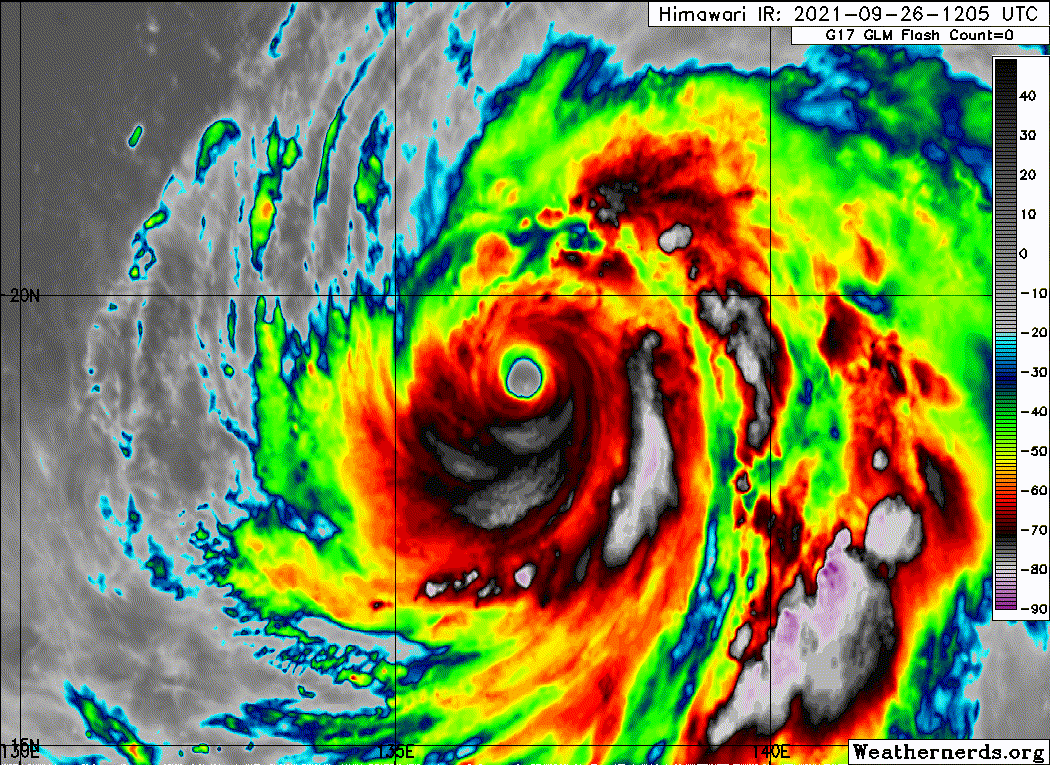
12Z AMSU 145 knots 
CIMSS/NESDIS-USAF/NRL AMSU TC Intensity Estimation:
SUPER TYPHOON 20W
Sunday 26sep21 Time: 1229 UTC
Latitude: 19.01 Longitude: 136.70
Storm position corresponds to AMSU-A FOV 25 [1<--->30]
-----------------------------------------------------------------
| Estimated MSLP: 907 hPa
| Estimated Maximum Sustained Wind: 145 kts
| Estimate Confidence: Good ( +/- 10mb +/- 12kts )
-----------------------------------------------------------------
Storm is sub-sampled: Bias correction applied is -6.6 hPa
Channel 8 (~150 hPa) Tb Anomaly: 5.01
Channel 7 (~250 hPa) Tb Anomaly: 4.60
RMW: 14 km
RMW Source is: MW
Environmental Pressure: 1005
Satellite: NOAA-90
ATCF data for Month: 09 Day: 26 Time (UTC): 1200
For imagery, go to http://amsu.ssec.wisc.edu
For all comments and questions mailto:chrisv@ssec.wisc.edu
0 likes
ヤンデレ女が寝取られるているのを見たい!!!
ECMWF ensemble NWPAC plots: https://ecmwfensnwpac.imgbb.com/
Multimodel NWPAC plots: https://multimodelnwpac.imgbb.com/
GFS Ensemble NWPAC plots (16 & 35 day forecast): https://gefsnwpac.imgbb.com/
Plots updated automatically
ECMWF ensemble NWPAC plots: https://ecmwfensnwpac.imgbb.com/
Multimodel NWPAC plots: https://multimodelnwpac.imgbb.com/
GFS Ensemble NWPAC plots (16 & 35 day forecast): https://gefsnwpac.imgbb.com/
Plots updated automatically
-
Sciencerocks
- Category 5
- Posts: 10186
- Age: 40
- Joined: Thu Jul 06, 2017 1:51 am

Re: WPAC: MINDULLE - Typhoon
Wow, the combo of an EWRC and upwelling has really knocked Mindulle down several pegs. 145 kt/908mb is still a very impressive peak, but it did seem like it could’ve ended up as another 150+ kt system based on how quickly it was getting its act together last night.
0 likes
Irene '11 Sandy '12 Hermine '16 5/15/2018 Derecho Fay '20 Isaias '20 Elsa '21 Henri '21 Ida '21
I am only a meteorology enthusiast who knows a decent amount about tropical cyclones. Look to the professional mets, the NHC, or your local weather office for the best information.
I am only a meteorology enthusiast who knows a decent amount about tropical cyclones. Look to the professional mets, the NHC, or your local weather office for the best information.


-
Yellow Evan

- Professional-Met

- Posts: 16240
- Age: 27
- Joined: Fri Jul 15, 2011 12:48 pm
- Location: Henderson, Nevada/Honolulu, HI
- Contact:
Re: WPAC: MINDULLE - Typhoon
This is probably irrecoverable because upwelling broadens the windfield big time, especially an apparent ERC ongoing. See Trami and Blanca as proof.
0 likes
-
Yellow Evan
- Professional-Met
- Posts: 16240
- Age: 27
- Joined: Fri Jul 15, 2011 12:48 pm
- Location: Henderson, Nevada/Honolulu, HI
- Contact:


Re: WPAC: MINDULLE - Typhoon
Trying to form a gigantic eye.
0 likes
Personal Forecast Disclaimer:
The posts in this forum are NOT official forecast and should not be used as such. They are just the opinion of the poster and may or may not be backed by sound meteorological data. For official information, please refer to the NHC and NWS products.
The posts in this forum are NOT official forecast and should not be used as such. They are just the opinion of the poster and may or may not be backed by sound meteorological data. For official information, please refer to the NHC and NWS products.

Re: WPAC: MINDULLE - Typhoon
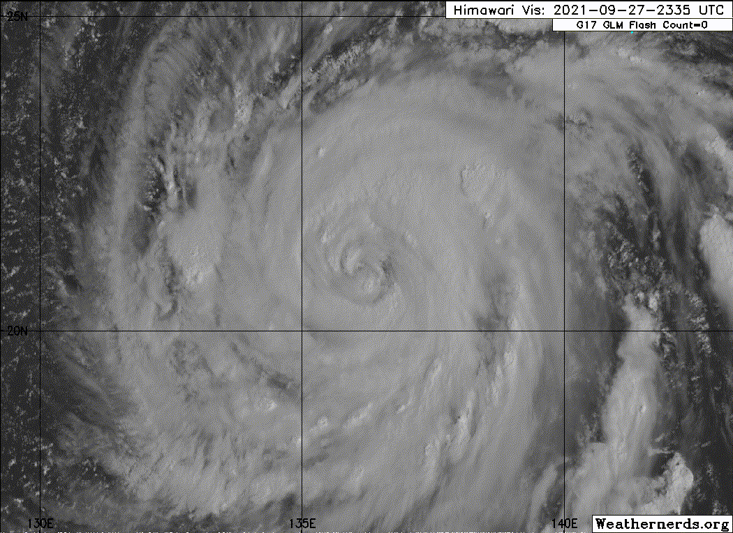
Yellow Evan wrote:https://cdn.discordapp.com/attachments/733552978572869632/891852218356084828/2021wp20_4kmirimg_202109270030.png
Never seen a storm upwell this much before.
Guess Mindulle and Sam are now having a competition over who weakens more rapidly.
2 likes
TC naming lists: retirements and intensity
Most aggressive Advisory #1's in North Atlantic (cr. kevin for starting the list)
Most aggressive Advisory #1's in North Atlantic (cr. kevin for starting the list)
Re: WPAC: MINDULLE - Typhoon
SMAP at 21Z leads 86 knots, 110 knots at 00Z could be too generous.
WP, 20, 202109262106, 30, SMAP, IR, , 1960N, 13670E, , 1, 80, 1, , , , 34, NEQ, 217, 204, 146, 172, , , , , 1, 0, , W, NASA, RSS, , , , , , , , , , , , , , , , , , , , , , , , , , , , 1, max. wind is 10 minute sustained
WP, 20, 202109262106, 30, SMAP, IR, , 1960N, 13670E, , 1, 80, 1, , , , 50, NEQ, 123, 89, 92, 104, , , , , 1, 0, , W, NASA, RSS, , , , , , , , , , , , , , , , , , , , , , , , , , , , 1, max. wind is 10 minute sustained
WP, 20, 202109262106, 30, SMAP, IR, , 1960N, 13670E, , 1, 80, 1, , , , 64, NEQ, 57, 62, 0, 70, , , , , 1, 0, , W, NASA, RSS, , , , , , , , , , , , , , , , , , , , , , , , , , , , 1, max. wind is 10 minute sustained
0 likes
ヤンデレ女が寝取られるているのを見たい!!!
ECMWF ensemble NWPAC plots: https://ecmwfensnwpac.imgbb.com/
Multimodel NWPAC plots: https://multimodelnwpac.imgbb.com/
GFS Ensemble NWPAC plots (16 & 35 day forecast): https://gefsnwpac.imgbb.com/
Plots updated automatically
ECMWF ensemble NWPAC plots: https://ecmwfensnwpac.imgbb.com/
Multimodel NWPAC plots: https://multimodelnwpac.imgbb.com/
GFS Ensemble NWPAC plots (16 & 35 day forecast): https://gefsnwpac.imgbb.com/
Plots updated automatically
Re: WPAC: MINDULLE - Typhoon
Teban54 wrote:Yellow Evan wrote:https://cdn.discordapp.com/attachments/733552978572869632/891852218356084828/2021wp20_4kmirimg_202109270030.png
Never seen a storm upwell this much before.
Guess Mindulle and Sam are now having a competition over who weakens more rapidly.
Trying to see who is better at botching an EWRC haha...
Larry truly is disappointed
1 likes
-
mrbagyo
- Category 5
- Posts: 3963
- Age: 33
- Joined: Thu Apr 12, 2012 9:18 am
- Location: 14.13N 120.98E
- Contact:
Re: WPAC: MINDULLE - Typhoon
Teban54 wrote:Yellow Evan wrote:https://cdn.discordapp.com/attachments/733552978572869632/891852218356084828/2021wp20_4kmirimg_202109270030.png
Never seen a storm upwell this much before.
Guess Mindulle and Sam are now having a competition over who weakens more rapidly.
Trami of 2018 did the same thing
0 likes
The posts in this forum are NOT official forecast and should not be used as such. They are just the opinion of the poster and may or may not be backed by sound meteorological data. They are NOT endorsed by any professional institution or storm2k.org. For official information, please refer to RSMC, NHC and NWS products.
Re: WPAC: MINDULLE - Typhoon
Teban54 wrote:Yellow Evan wrote:https://cdn.discordapp.com/attachments/733552978572869632/891852218356084828/2021wp20_4kmirimg_202109270030.png
Never seen a storm upwell this much before.
Guess Mindulle and Sam are now having a competition over who weakens more rapidly.
Sam will probably fare better. At least it hasn’t upwelled much and has just one eyewall instead of like 3.
0 likes
Irene '11 Sandy '12 Hermine '16 5/15/2018 Derecho Fay '20 Isaias '20 Elsa '21 Henri '21 Ida '21
I am only a meteorology enthusiast who knows a decent amount about tropical cyclones. Look to the professional mets, the NHC, or your local weather office for the best information.
I am only a meteorology enthusiast who knows a decent amount about tropical cyclones. Look to the professional mets, the NHC, or your local weather office for the best information.
-
mrbagyo
- Category 5
- Posts: 3963
- Age: 33
- Joined: Thu Apr 12, 2012 9:18 am
- Location: 14.13N 120.98E
- Contact:
Re: WPAC: MINDULLE - Typhoon
convection has started to cool again.

1 likes
The posts in this forum are NOT official forecast and should not be used as such. They are just the opinion of the poster and may or may not be backed by sound meteorological data. They are NOT endorsed by any professional institution or storm2k.org. For official information, please refer to RSMC, NHC and NWS products.
-
mrbagyo
- Category 5
- Posts: 3963
- Age: 33
- Joined: Thu Apr 12, 2012 9:18 am
- Location: 14.13N 120.98E
- Contact:
Re: WPAC: MINDULLE - Typhoon

0 likes
The posts in this forum are NOT official forecast and should not be used as such. They are just the opinion of the poster and may or may not be backed by sound meteorological data. They are NOT endorsed by any professional institution or storm2k.org. For official information, please refer to RSMC, NHC and NWS products.
-
Sciencerocks
- Category 5
- Posts: 10186
- Age: 40
- Joined: Thu Jul 06, 2017 1:51 am
-
dexterlabio
- Category 5
- Posts: 3509
- Joined: Sat Oct 24, 2009 11:50 pm
Re: WPAC: MINDULLE - Typhoon
If Mindulle was the size of Sam it could have undergone a smoother EWRC
0 likes
Personal Forecast Disclaimer:
The posts in this forum are NOT official forecast and should not be used as such. They are just the opinion of the poster and may or may not be backed by sound meteorological data. They are NOT endorsed by any professional institution or storm2k.org. For official information, please refer to the NHC and NWS products.
The posts in this forum are NOT official forecast and should not be used as such. They are just the opinion of the poster and may or may not be backed by sound meteorological data. They are NOT endorsed by any professional institution or storm2k.org. For official information, please refer to the NHC and NWS products.
-
StormTracker89
- Tropical Depression

- Posts: 57
- Joined: Sat May 16, 2020 3:47 pm
- Location: Somewhere in the Pacific
Re: WPAC: MINDULLE - Typhoon
VHTs popping, and a new much small eye rapidly forming. Standby for a sharp boost in the Dvorak estimates.
0 likes
Who is online
Users browsing this forum: No registered users and 52 guests