ATL: SAM - Remnants - Discussion
Moderator: S2k Moderators
-
Sciencerocks
- Category 5

- Posts: 10186
- Age: 40
- Joined: Thu Jul 06, 2017 1:51 am

Re: ATL: SAM - Hurricane - Discussion
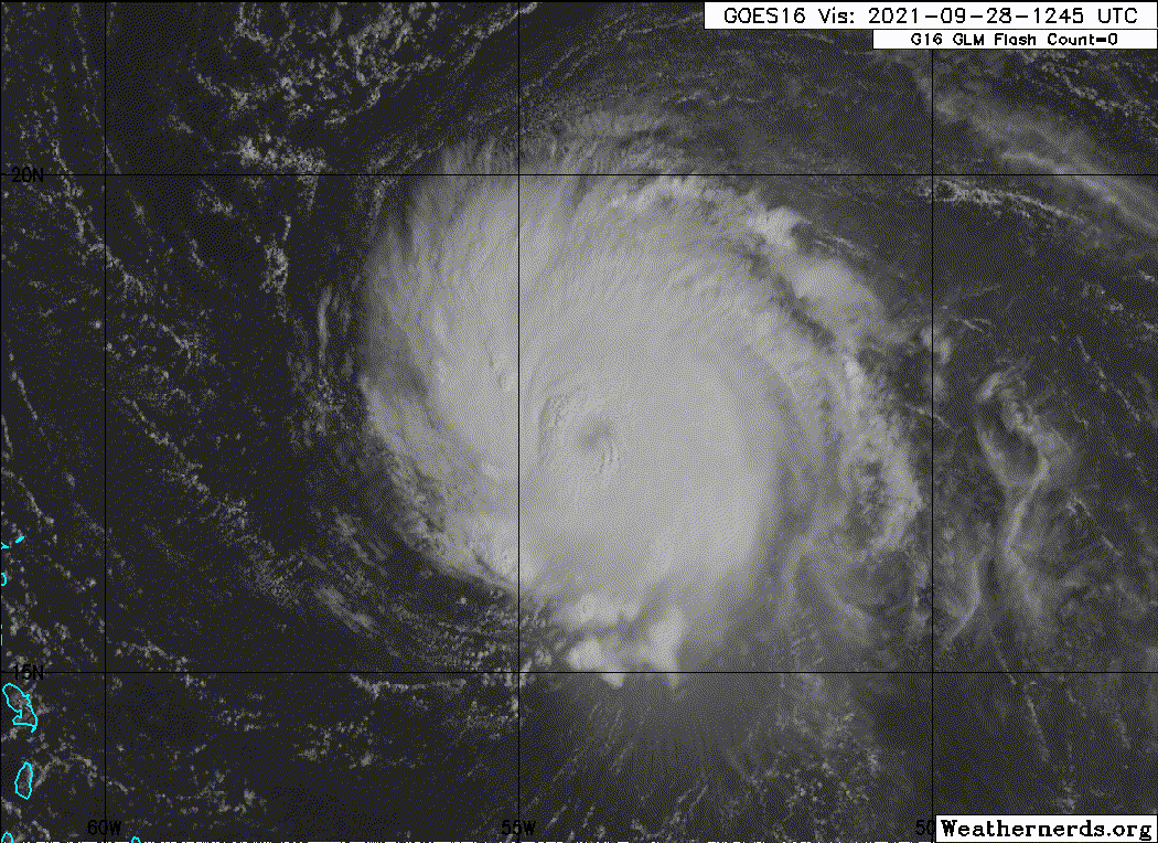
kevin wrote:First visual of Sam today. Still has to clear out the eye on visual, but it's already cleared out on IR. Looks quite healthy. I think ~7 hours from now might be the perfect time for recon to catch Sam at another peak as it'll give the Wring time to fix itself (broken to the NE right now) and the eye time to clear out. Raw T# up to 6.4 btw.
https://i.imgur.com/5hTj1vl.jpg
He's beautiful!
3 likes
Cleo - 1964, Betsy - 1965, David - 1979, Andrew - 1992, Charlie (Francis, Ivan, Jeanne) - 2004, Irma - 2017, Ian - 2022, Milton - 2024

Re: ATL: SAM - Hurricane - Discussion
First pass 945.5 mbar with 118 kt FL and 120 kt SFMR. Considering the pressure drop since the previous recon I would assume the strongest quadrant has 120 kt so that would be 946mb/120kt. Despite a less than great IR appearance it looks like Sam is intensifying. If Sam is already this strong now I think there might still be an outside shot for a high-end cat 4 or low-end cat 5 tomorrow when it passes over higher OHC.
3 likes
-
wxman57

- Moderator-Pro Met

- Posts: 23175
- Age: 68
- Joined: Sat Jun 21, 2003 8:06 pm
- Location: Houston, TX (southwest)
Re: ATL: SAM - Hurricane - Discussion
I'm thinking that the data support 110 kts surface wind. The higher SFMR values were flagged as unreliable, with the exception of a 74kt FL and 120kt SFMR wind, which seems unreasonable. NHC will probably keep it 115 kts.
3 likes
Re: ATL: SAM - Hurricane - Discussion
Anyone else who can no longer find Sam as a floater on Tropicaltidbits?
0 likes
-
wxman57
- Moderator-Pro Met
- Posts: 23175
- Age: 68
- Joined: Sat Jun 21, 2003 8:06 pm
- Location: Houston, TX (southwest)
Re: ATL: SAM - Hurricane - Discussion
kevin wrote:Anyone else who can no longer find Sam as a floater on Tropicaltidbits?
I see it listed to the right of 90L and 91L.
1 likes
Re: ATL: SAM - Hurricane - Discussion
wxman57 wrote:kevin wrote:Anyone else who can no longer find Sam as a floater on Tropicaltidbits?
I see it listed to the right of 90L and 91L.
Yes, it's also back now for me. No idea what happened there, maybe an issue on my side. Thanks.
0 likes
-
cheezyWXguy

- Category 5
- Posts: 6282
- Joined: Mon Feb 13, 2006 12:29 am
- Location: Dallas, TX
Re: ATL: SAM - Hurricane - Discussion
kevin wrote:wxman57 wrote:kevin wrote:Anyone else who can no longer find Sam as a floater on Tropicaltidbits?
I see it listed to the right of 90L and 91L.
Yes, it's also back now for me. No idea what happened there, maybe an issue on my side. Thanks.
There were some really exciting cumulus clouds over Texas they had to switch to
2 likes

Re: ATL: SAM - Hurricane - Discussion
kevin wrote:First pass 945.5 mbar with 118 kt FL and 120 kt SFMR. Considering the pressure drop since the previous recon I would assume the strongest quadrant has 120 kt so that would be 946mb/120kt. Despite a less than great IR appearance it looks like Sam is intensifying. If Sam is already this strong now I think there might still be an outside shot for a high-end cat 4 or low-end cat 5 tomorrow when it passes over higher OHC.
Are there any plausible explanations why Sam might still be intensifying (and definitely still deepening) even though it looks like crap on IR?
0 likes
TC naming lists: retirements and intensity
Most aggressive Advisory #1's in North Atlantic (cr. kevin for starting the list)
Most aggressive Advisory #1's in North Atlantic (cr. kevin for starting the list)
-
grapealcoholic
- Category 2

- Posts: 703
- Joined: Tue Aug 10, 2021 3:26 pm
Re: ATL: SAM - Hurricane - Discussion
skyline385 wrote:Think Sam is a good example of why ACE needs to be updated (with wind radii at the very least), its so tiny and is just chilling out there massively inflating the ACE for the season and will end up having much more ACE than even Ida which was a stronger system...
It balances out when you account for the nonlinearity of the kinetic energy calculation -- extreme winds produce significantly more energy than moderate winds
0 likes
-
grapealcoholic
- Category 2
- Posts: 703
- Joined: Tue Aug 10, 2021 3:26 pm
Re: ATL: SAM - Hurricane - Discussion
Teban54 wrote:kevin wrote:First pass 945.5 mbar with 118 kt FL and 120 kt SFMR. Considering the pressure drop since the previous recon I would assume the strongest quadrant has 120 kt so that would be 946mb/120kt. Despite a less than great IR appearance it looks like Sam is intensifying. If Sam is already this strong now I think there might still be an outside shot for a high-end cat 4 or low-end cat 5 tomorrow when it passes over higher OHC.
Are there any plausible explanations why Sam might still be intensifying (and definitely still deepening) even though it looks like crap on IR?
Low and mid-levels look good on microwave so inner core pressure is staying low
0 likes
-
Extratropical94

- Professional-Met

- Posts: 3545
- Age: 31
- Joined: Wed Oct 20, 2010 6:36 am
- Location: Hamburg, Germany
- Contact:
Re: ATL: SAM - Hurricane - Discussion
948/10kts on the center drop, so the pressure is at 947 now.
7 likes
54° 11' 59'' N, 9° 9' 20'' E
Boomer Sooner!
Go Broncos! Go Cards!
Clinching counties, one at a time: https://mob-rule.com/user-gifs/USA/xtrp94.gif
- Daniel
Boomer Sooner!
Go Broncos! Go Cards!
Clinching counties, one at a time: https://mob-rule.com/user-gifs/USA/xtrp94.gif
- Daniel
-
grapealcoholic
- Category 2
- Posts: 703
- Joined: Tue Aug 10, 2021 3:26 pm
Re: ATL: SAM - Hurricane - Discussion
Also something about ADT -- it's pretty smart about not jumping the gun to weaken a storm. CI is still at 119 kts

0 likes

Re: ATL: SAM - Hurricane - Discussion
Teban54 wrote:kevin wrote:First pass 945.5 mbar with 118 kt FL and 120 kt SFMR. Considering the pressure drop since the previous recon I would assume the strongest quadrant has 120 kt so that would be 946mb/120kt. Despite a less than great IR appearance it looks like Sam is intensifying. If Sam is already this strong now I think there might still be an outside shot for a high-end cat 4 or low-end cat 5 tomorrow when it passes over higher OHC.
Are there any plausible explanations why Sam might still be intensifying (and definitely still deepening) even though it looks like crap on IR?
The current structure is good enough for deepening, but it would appear that Sam’s outflow setup is quite poor, preventing the eye from clearing out. Unless the setup improves in the next 36 hours, this is as strong as Sam’s gonna get.
0 likes
Irene '11 Sandy '12 Hermine '16 5/15/2018 Derecho Fay '20 Isaias '20 Elsa '21 Henri '21 Ida '21
I am only a meteorology enthusiast who knows a decent amount about tropical cyclones. Look to the professional mets, the NHC, or your local weather office for the best information.
I am only a meteorology enthusiast who knows a decent amount about tropical cyclones. Look to the professional mets, the NHC, or your local weather office for the best information.


-
Iceresistance

- Category 5
- Posts: 9592
- Age: 22
- Joined: Sat Oct 10, 2020 9:45 am
- Location: Tecumseh, OK/Norman, OK
Re: ATL: SAM - Hurricane - Discussion
cheezyWXguy wrote:kevin wrote:wxman57 wrote:
I see it listed to the right of 90L and 91L.
Yes, it's also back now for me. No idea what happened there, maybe an issue on my side. Thanks.
There were some really exciting cumulus clouds over Texas they had to switch to
WeatherNerds does not need Floaters for Systems, you can zoom to one of them to track . . .
0 likes
Bill 2015 & Beta 2020
Winter 2020-2021
All observations are in Tecumseh, OK unless otherwise noted.
Winter posts are focused mainly for Oklahoma & Texas.
Take any of my forecasts with a grain of salt, refer to the NWS, SPC, and NHC for official information
Never say Never with weather! Because ANYTHING is possible!
Winter 2020-2021
All observations are in Tecumseh, OK unless otherwise noted.
Winter posts are focused mainly for Oklahoma & Texas.
Take any of my forecasts with a grain of salt, refer to the NWS, SPC, and NHC for official information
Never say Never with weather! Because ANYTHING is possible!
Re: ATL: SAM - Hurricane - Discussion
zzh wrote:https://i.imgur.com/zwMphV2.jpg
I’m guessing the weak SE eyewall is an issue too. Must be a bit of shear that got just enough dry air into Sam’s circulation.
0 likes
Irene '11 Sandy '12 Hermine '16 5/15/2018 Derecho Fay '20 Isaias '20 Elsa '21 Henri '21 Ida '21
I am only a meteorology enthusiast who knows a decent amount about tropical cyclones. Look to the professional mets, the NHC, or your local weather office for the best information.
I am only a meteorology enthusiast who knows a decent amount about tropical cyclones. Look to the professional mets, the NHC, or your local weather office for the best information.
-
wxman57
- Moderator-Pro Met
- Posts: 23175
- Age: 68
- Joined: Sat Jun 21, 2003 8:06 pm
- Location: Houston, TX (southwest)
Re: ATL: SAM - Hurricane - Discussion
I use RealEarth (SSEC) for satellite data worldwide. Can choose which satellite to use. You can see my preferences in the screenshot below. I have GOES-East True Color selected. The only issue with RealEarth is the looping is a bit clunky.
https://realearth.ssec.wisc.edu/

https://realearth.ssec.wisc.edu/
6 likes
-
wxman57
- Moderator-Pro Met
- Posts: 23175
- Age: 68
- Joined: Sat Jun 21, 2003 8:06 pm
- Location: Houston, TX (southwest)
Re: ATL: SAM - Hurricane - Discussion
Here's a zoomed-in true color view of Sam using RealEarth:

7 likes
-
Iceresistance
- Category 5
- Posts: 9592
- Age: 22
- Joined: Sat Oct 10, 2020 9:45 am
- Location: Tecumseh, OK/Norman, OK
Re: ATL: SAM - Hurricane - Discussion
Does Sam look like an Annular Hurricane on Satellite?
0 likes
Bill 2015 & Beta 2020
Winter 2020-2021
All observations are in Tecumseh, OK unless otherwise noted.
Winter posts are focused mainly for Oklahoma & Texas.
Take any of my forecasts with a grain of salt, refer to the NWS, SPC, and NHC for official information
Never say Never with weather! Because ANYTHING is possible!
Winter 2020-2021
All observations are in Tecumseh, OK unless otherwise noted.
Winter posts are focused mainly for Oklahoma & Texas.
Take any of my forecasts with a grain of salt, refer to the NWS, SPC, and NHC for official information
Never say Never with weather! Because ANYTHING is possible!
Who is online
Users browsing this forum: No registered users and 36 guests