ATL: VICTOR - Remnants - Discussion
Moderator: S2k Moderators
-
CyclonicFury

- Category 5

- Posts: 2035
- Age: 27
- Joined: Sun Jul 02, 2017 12:32 pm
- Location: NC
- Contact:
Re: ATL: INVEST 90L - Discussion
This has potential to be a rare October Cape Verde hurricane, even if its intensification window isn't very long.
6 likes
NCSU B.S. in Meteorology Class of 2021. Tropical weather blogger at http://www.cyclonicfury.com. My forecasts and thoughts are NOT official, for official forecasts please consult the National Hurricane Center.
-
cycloneye

- Admin

- Posts: 149520
- Age: 69
- Joined: Thu Oct 10, 2002 10:54 am
- Location: San Juan, Puerto Rico
Re: ATL: INVEST 90L - Discussion
Showers and thunderstorms are showing signs of organization in
association with a tropical wave and broad area of low pressure
located over the far eastern tropical Atlantic. Environmental
conditions are conducive for development, and a tropical depression
is likely to form in a day or two while the disturbance moves
west-northwestward at 10 to 15 mph over the eastern tropical
Atlantic.
* Formation chance through 48 hours...high...80 percent.
* Formation chance through 5 days...high...90 percent.
0 likes
Visit the Caribbean-Central America Weather Thread where you can find at first post web cams,radars
and observations from Caribbean basin members Click Here
and observations from Caribbean basin members Click Here
-
cycloneye
- Admin
- Posts: 149520
- Age: 69
- Joined: Thu Oct 10, 2002 10:54 am
- Location: San Juan, Puerto Rico
Re: ATL: INVEST 90L - Discussion
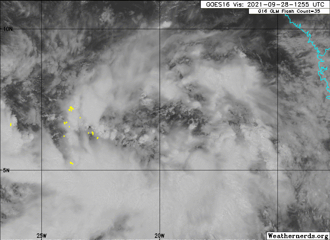
As of 12:00 UTC Sep 28, 2021:
Location: 6.7°N 19.7°W
Maximum Winds: 25 kt Gusts: N/A
Minimum Central Pressure: 1010 mb
Location: 6.7°N 19.7°W
Maximum Winds: 25 kt Gusts: N/A
Minimum Central Pressure: 1010 mb
0 likes
Visit the Caribbean-Central America Weather Thread where you can find at first post web cams,radars
and observations from Caribbean basin members Click Here
and observations from Caribbean basin members Click Here
-
cycloneye
- Admin
- Posts: 149520
- Age: 69
- Joined: Thu Oct 10, 2002 10:54 am
- Location: San Juan, Puerto Rico
Re: ATL: INVEST 90L - Discussion
1 likes
Visit the Caribbean-Central America Weather Thread where you can find at first post web cams,radars
and observations from Caribbean basin members Click Here
and observations from Caribbean basin members Click Here
-
Sciencerocks
- Category 5
- Posts: 10186
- Age: 40
- Joined: Thu Jul 06, 2017 1:51 am
-
CyclonicFury
- Category 5
- Posts: 2035
- Age: 27
- Joined: Sun Jul 02, 2017 12:32 pm
- Location: NC
- Contact:
Re: ATL: INVEST 90L - Discussion
It definitely seems like 90L is becoming the dominant of the two monsoon trough disturbances. 90L is a very large system and it will likely take a day or two for the LLC to become well defined enough for classification. It reminds me of Hurricane Helene from 2018. It has about 3-4 days of low shear, so a hurricane is definitely possible.
4 likes
NCSU B.S. in Meteorology Class of 2021. Tropical weather blogger at http://www.cyclonicfury.com. My forecasts and thoughts are NOT official, for official forecasts please consult the National Hurricane Center.
-
Sciencerocks
- Category 5
- Posts: 10186
- Age: 40
- Joined: Thu Jul 06, 2017 1:51 am
Re: ATL: INVEST 90L - Discussion
A broad area of low pressure located over the far eastern Atlantic
several hundred miles south-southeast of the Cabo Verde Islands is
producing a large area of showers and thunderstorms. This shower
activity is gradually becoming better organized, and a tropical
depression is expected to form in a day or so while the disturbance
moves west-northwestward at 10 to 15 mph over the eastern tropical
Atlantic.
* Formation chance through 48 hours...high...90 percent.
* Formation chance through 5 days...high...90 percent.
0 likes
-
ScottNAtlanta

- Category 5
- Posts: 2535
- Joined: Sat May 25, 2013 3:11 pm
- Location: Atlanta, GA
Re: ATL: INVEST 90L - Discussion
It is very far south. Furthest south of any of the invests this season.
1 likes
The posts in this forum are NOT official forecast and should not be used as such. They are just the opinion of the poster and may or may not be backed by sound meteorological data. They are NOT endorsed by any professional institution or storm2k.org. For official information, please refer to the NHC and NWS products.

Re: ATL: INVEST 90L - Discussion
90L is gonna be the winner here, it seems. It’s clearly the dominant system and all models have shifted focus onto it.
Based on the GFS and HWRF upper level wind forecasts, 90L/Victor will be in a favorable low-shear environment with acceptable ventilation until Friday afternoon or night. They also have a TC by midday tomorrow. Victor would have about 48-60 hours to intensify and could become a very rare late September eastern MDR hurricane.
Based on the GFS and HWRF upper level wind forecasts, 90L/Victor will be in a favorable low-shear environment with acceptable ventilation until Friday afternoon or night. They also have a TC by midday tomorrow. Victor would have about 48-60 hours to intensify and could become a very rare late September eastern MDR hurricane.
3 likes
Irene '11 Sandy '12 Hermine '16 5/15/2018 Derecho Fay '20 Isaias '20 Elsa '21 Henri '21 Ida '21
I am only a meteorology enthusiast who knows a decent amount about tropical cyclones. Look to the professional mets, the NHC, or your local weather office for the best information.
I am only a meteorology enthusiast who knows a decent amount about tropical cyclones. Look to the professional mets, the NHC, or your local weather office for the best information.
-
Yellow Evan

- Professional-Met

- Posts: 16241
- Age: 27
- Joined: Fri Jul 15, 2011 12:48 pm
- Location: Henderson, Nevada/Honolulu, HI
- Contact:
Re: ATL: INVEST 90L - Discussion
This is basically a Pacific style genesis in the Atlantic which is really fascinating to see.
6 likes
-
grapealcoholic
- Category 2

- Posts: 703
- Joined: Tue Aug 10, 2021 3:26 pm
Re: ATL: INVEST 90L - Discussion
90L could reasonably tack on another 20+ ACE if it develops quick like HWRF shows
1 likes
-
Sciencerocks
- Category 5
- Posts: 10186
- Age: 40
- Joined: Thu Jul 06, 2017 1:51 am


Re: ATL: INVEST 90L - Discussion
Recent satellite-derived surface wind data indicate that the low
pressure system located over the far eastern tropical Atlantic
several hundred miles south of the Cabo Verde Islands is gradually
becoming better defined. The associated showers and thunderstorms
are showing signs of organization, and a tropical depression is
expected to form during the next day or so while the disturbance
moves west-northwestward at 10 to 15 mph over the eastern tropical
Atlantic.
* Formation chance through 48 hours...high...90 percent.
* Formation chance through 5 days...high...90 percent.
0 likes
-
cycloneye
- Admin
- Posts: 149520
- Age: 69
- Joined: Thu Oct 10, 2002 10:54 am
- Location: San Juan, Puerto Rico
Re: ATL: INVEST 90L - Discussion
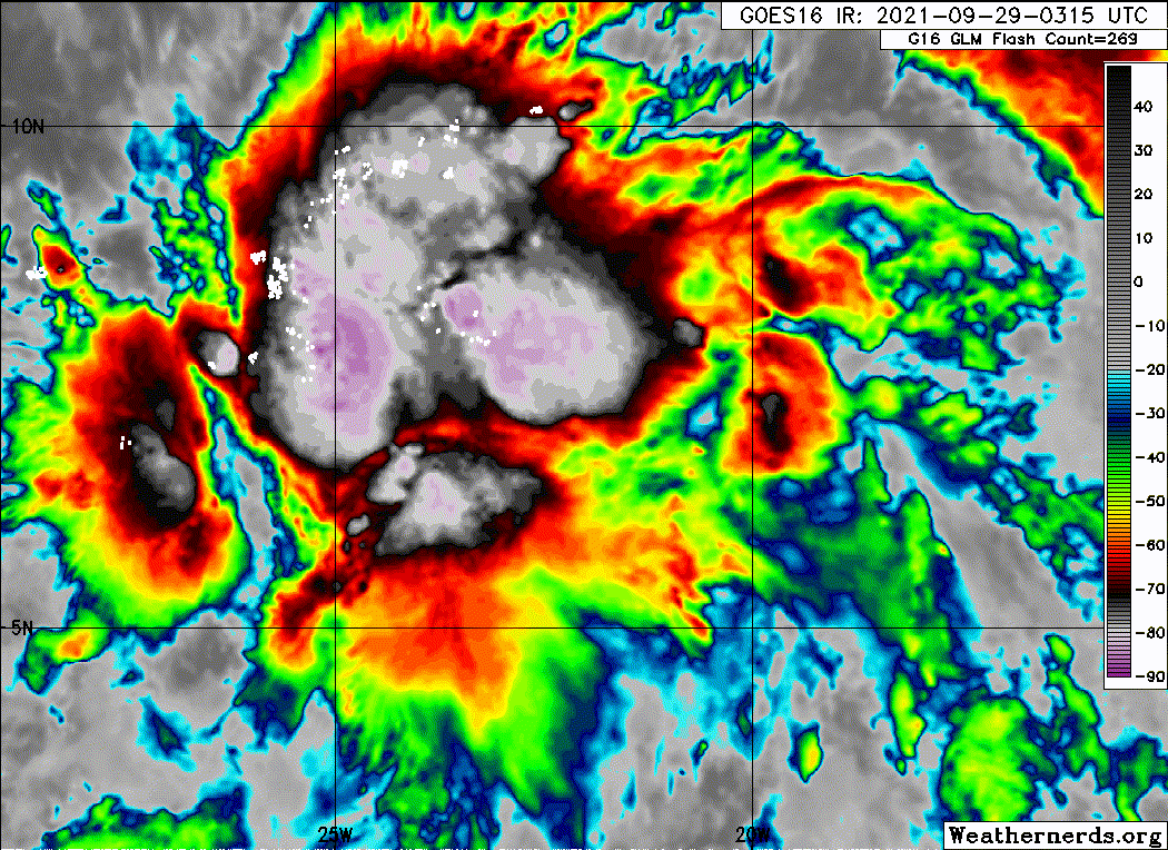
A. TROPICAL DISTURBANCE (90L)
B. 28/2330Z
C. 8.1N
D. 22.7W
E. THREE/MET-11
F. T1.0/1.0
G. IR/EIR/SWIR
H. REMARKS...GREATER THAN 2/10 BANDING RESULTS IN A DT OF 1.0. MET AND
PT=1.0. FT IS BASED ON DT.
I. ADDL POSITIONS
NIL
...KONON
B. 28/2330Z
C. 8.1N
D. 22.7W
E. THREE/MET-11
F. T1.0/1.0
G. IR/EIR/SWIR
H. REMARKS...GREATER THAN 2/10 BANDING RESULTS IN A DT OF 1.0. MET AND
PT=1.0. FT IS BASED ON DT.
I. ADDL POSITIONS
NIL
...KONON
0 likes
Visit the Caribbean-Central America Weather Thread where you can find at first post web cams,radars
and observations from Caribbean basin members Click Here
and observations from Caribbean basin members Click Here
-
cycloneye
- Admin
- Posts: 149520
- Age: 69
- Joined: Thu Oct 10, 2002 10:54 am
- Location: San Juan, Puerto Rico
Re: ATL: INVEST 90L - Discussion
AL, 90, 2021092900, , BEST, 0, 70N, 220W, 10, 1008, LO
0 likes
Visit the Caribbean-Central America Weather Thread where you can find at first post web cams,radars
and observations from Caribbean basin members Click Here
and observations from Caribbean basin members Click Here
Re: ATL: INVEST 90L - Discussion
Convection is exploding tonight. This might be a TD by the 11am advisory at this rate.
5 likes
Irene '11 Sandy '12 Hermine '16 5/15/2018 Derecho Fay '20 Isaias '20 Elsa '21 Henri '21 Ida '21
I am only a meteorology enthusiast who knows a decent amount about tropical cyclones. Look to the professional mets, the NHC, or your local weather office for the best information.
I am only a meteorology enthusiast who knows a decent amount about tropical cyclones. Look to the professional mets, the NHC, or your local weather office for the best information.
-
grapealcoholic
- Category 2
- Posts: 703
- Joined: Tue Aug 10, 2021 3:26 pm
Re: ATL: INVEST 90L - Discussion
aspen wrote:Convection is exploding tonight. This might be a TD by the 11am advisory at this rate.
5am if we get an ASCAT
1 likes


Re: ATL: INVEST 90L - Discussion
Definitely could make a run at hurricane intensity based off of recent model runs and convective activity. Thing is looking beastly.
2 likes
-
Sciencerocks
- Category 5
- Posts: 10186
- Age: 40
- Joined: Thu Jul 06, 2017 1:51 am
Re: ATL: INVEST 90L - Discussion
There has been persistent deep convection over where the LLC is likely consolidating for hours now, and the system’s overall structure is improving. This is very close to becoming a TC if it isn’t one already.
Edit: the 8pm TWO says advisories will be initiated if development trends continue. We might have Victor at 11am
Edit: the 8pm TWO says advisories will be initiated if development trends continue. We might have Victor at 11am
1 likes
Irene '11 Sandy '12 Hermine '16 5/15/2018 Derecho Fay '20 Isaias '20 Elsa '21 Henri '21 Ida '21
I am only a meteorology enthusiast who knows a decent amount about tropical cyclones. Look to the professional mets, the NHC, or your local weather office for the best information.
I am only a meteorology enthusiast who knows a decent amount about tropical cyclones. Look to the professional mets, the NHC, or your local weather office for the best information.
Who is online
Users browsing this forum: No registered users and 24 guests