2021 Global Model Runs Discussion (Out thru day 16)
Moderator: S2k Moderators
Forum rules

The posts in this forum are NOT official forecasts and should not be used as such. They are just the opinion of the poster and may or may not be backed by sound meteorological data. They are NOT endorsed by any professional institution or STORM2K. For official information, please refer to products from the National Hurricane Center and National Weather Service.

Re: 2021 Global Model Runs Discussion (Out thru day 16)
6Z GFS suite is still another that is very quiet overall in the W Caribbean with only one TC. It does though once again have a couple of members off the SE coast at midmonth that then hit FL fwiw.
0 likes
Personal Forecast Disclaimer:
The posts in this forum are NOT official forecasts and should not be used as such. They are just the opinion of the poster and may or may not be backed by sound meteorological data. They are NOT endorsed by any professional institution or storm2k.org. For official information, please refer to the NHC and NWS products.
The posts in this forum are NOT official forecasts and should not be used as such. They are just the opinion of the poster and may or may not be backed by sound meteorological data. They are NOT endorsed by any professional institution or storm2k.org. For official information, please refer to the NHC and NWS products.

Re: 2021 Global Model Runs Discussion (Out thru day 16)
CFS for today is back to showing development in the 19-22 timeframe. It dropped it yesterday after showing it for several days prior. We will know shortly if this is bogus.

0 likes
The following post is NOT an official forecast and should not be used as such. It is just the opinion of the poster and may or may not be backed by sound meteorological data. It is NOT endorsed by any professional institution including storm2k.org For Official Information please refer to the NHC and NWS products.
-
Category5Kaiju

- Category 5

- Posts: 4335
- Joined: Thu Dec 24, 2020 12:45 pm
- Location: Seattle and Phoenix
Re: 2021 Global Model Runs Discussion (Out thru day 16)
If this image were to be believed, I am willing to bet that activity will resume starting around mid-month, so a little between a week or two.
0 likes
Unless explicitly stated, all info in my posts is based on my own opinions and observations. Tropical storms and hurricanes can be extremely dangerous. Refer to an accredited weather research agency or meteorologist if you need to make serious decisions regarding an approaching storm.
Re: 2021 Global Model Runs Discussion (Out thru day 16)
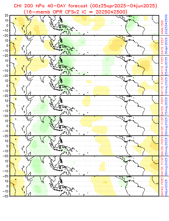
Category5Kaiju wrote:https://www.cpc.ncep.noaa.gov/products/people/wd52qz/mjo/chi/cfs.gif
If this image were to be believed, I am willing to bet that activity will resume starting around mid-month, so a little between a week or two.
And that could be what helps genesis off the SE US coast.
0 likes
Personal Forecast Disclaimer:
The posts in this forum are NOT official forecasts and should not be used as such. They are just the opinion of the poster and may or may not be backed by sound meteorological data. They are NOT endorsed by any professional institution or storm2k.org. For official information, please refer to the NHC and NWS products.
The posts in this forum are NOT official forecasts and should not be used as such. They are just the opinion of the poster and may or may not be backed by sound meteorological data. They are NOT endorsed by any professional institution or storm2k.org. For official information, please refer to the NHC and NWS products.
-
wxman57

- Moderator-Pro Met

- Posts: 23175
- Age: 68
- Joined: Sat Jun 21, 2003 8:06 pm
- Location: Houston, TX (southwest)
Re: 2021 Global Model Runs Discussion (Out thru day 16)
I still think that the Gulf of Mexico may be done for the season. Very strong wind shear for the next couple of weeks. Can't rule out development in the subtropical Atlantic or perhaps in the Caribbean. No back-loaded season like last year. Pretty normal-looking out there for October.
6 likes


Re: 2021 Global Model Runs Discussion (Out thru day 16)
wxman57 wrote:I still think that the Gulf of Mexico may be done for the season. Very strong wind shear for the next couple of weeks. Can't rule out development in the subtropical Atlantic or perhaps in the Caribbean. No back-loaded season like last year. Pretty normal-looking out there for October.
I agree. Might as well be in an El Nino by the looks of things. I now firmly believe Sam was the last hurricane of the year. It's been a long season regardless, with nonstop activity since early August. 20 named storms (above normal), 7 hurricane (normal), 4 majors (slightly above normal) with an ACE of 139.5 units as of now, so if this hurricane season does indeed drop everything and run away to never return, we still ended mostly above average, except for number of hurricanes.
1 likes
-
Category5Kaiju
- Category 5
- Posts: 4335
- Joined: Thu Dec 24, 2020 12:45 pm
- Location: Seattle and Phoenix
Re: 2021 Global Model Runs Discussion (Out thru day 16)
WiscoWx02 wrote:wxman57 wrote:I still think that the Gulf of Mexico may be done for the season. Very strong wind shear for the next couple of weeks. Can't rule out development in the subtropical Atlantic or perhaps in the Caribbean. No back-loaded season like last year. Pretty normal-looking out there for October.
I agree. Might as well be in an El Nino by the looks of things. I now firmly believe Sam was the last hurricane of the year. It's been a long season regardless, with nonstop activity since early August. 20 named storms (above normal), 7 hurricane (normal), 4 majors (slightly above normal) with an ACE of 139.5 units as of now, so if this hurricane season does indeed drop everything and run away to never return, we still ended mostly above average, except for number of hurricanes.
So what exactly makes you think that we cannot get hurricanes after mid-October or November? Just curious of course.
0 likes
Unless explicitly stated, all info in my posts is based on my own opinions and observations. Tropical storms and hurricanes can be extremely dangerous. Refer to an accredited weather research agency or meteorologist if you need to make serious decisions regarding an approaching storm.

Re: 2021 Global Model Runs Discussion (Out thru day 16)
The GFS remains consistent with that Omar-like storm in the ECar/central Atlantic next week. If it does form and become a hurricane like modeled, it would boost ACE a bit but could be a bit of an issue for Puerto Rico.
0 likes
Irene '11 Sandy '12 Hermine '16 5/15/2018 Derecho Fay '20 Isaias '20 Elsa '21 Henri '21 Ida '21
I am only a meteorology enthusiast who knows a decent amount about tropical cyclones. Look to the professional mets, the NHC, or your local weather office for the best information.
I am only a meteorology enthusiast who knows a decent amount about tropical cyclones. Look to the professional mets, the NHC, or your local weather office for the best information.
Re: 2021 Global Model Runs Discussion (Out thru day 16)
Category5Kaiju wrote:WiscoWx02 wrote:wxman57 wrote:I still think that the Gulf of Mexico may be done for the season. Very strong wind shear for the next couple of weeks. Can't rule out development in the subtropical Atlantic or perhaps in the Caribbean. No back-loaded season like last year. Pretty normal-looking out there for October.
I agree. Might as well be in an El Nino by the looks of things. I now firmly believe Sam was the last hurricane of the year. It's been a long season regardless, with nonstop activity since early August. 20 named storms (above normal), 7 hurricane (normal), 4 majors (slightly above normal) with an ACE of 139.5 units as of now, so if this hurricane season does indeed drop everything and run away to never return, we still ended mostly above average, except for number of hurricanes.
So what exactly makes you think that we cannot get hurricanes after mid-October or November? Just curious of course.
Oh God this was meant for a different thread...thought I was on indicators for a second
0 likes
-
AutoPenalti
- Category 5
- Posts: 4091
- Age: 29
- Joined: Mon Aug 17, 2015 4:16 pm
- Location: Ft. Lauderdale, Florida
Re: 2021 Global Model Runs Discussion (Out thru day 16)
Euro upgrades:
Extratropical upper-air geopotential and wind in the first few days of the forecast improved by 1-2%
Tropical upper-air winds throughout the medium-range improved by 1-4%
Tropical upper-air temperature improved in HRES, but degraded CRPS in ENS due to small (~0.2K) increase in bias. Low level temperatures (including 850hPa and 2m) temperature approximately neutral versus observations but degraded versus analysis over subtropical ocean.
Tropical Cyclones: Small improvement in position and central pressure absolute error
Improved MJO prediction and amplitude
More realistic precipitation PDF in strongly convective regimes
Increased convective precipitation (reduced dry bias) in arid regions
Increase in small scale structure for cloud and precipitation but total cloud cover degraded
Reduced biases for wind gusts and for visibility in fog, rain and snow
2 likes
The posts in this forum are NOT official forecasts and should not be used as such. They are just the opinion of the poster and may or may not be backed by sound meteorological data. They are NOT endorsed by any professional institution or STORM2K. For official information, please refer to products from the NHC and NWS.
Model Runs Cheat Sheet:
GFS (5:30 AM/PM, 11:30 AM/PM)
HWRF, GFDL, UKMET, NAVGEM (6:30-8:00 AM/PM, 12:30-2:00 AM/PM)
ECMWF (1:45 AM/PM)
TCVN is a weighted averaged
-
wxman57
- Moderator-Pro Met
- Posts: 23175
- Age: 68
- Joined: Sat Jun 21, 2003 8:06 pm
- Location: Houston, TX (southwest)
Re: 2021 Global Model Runs Discussion (Out thru day 16)
Category5Kaiju wrote:WiscoWx02 wrote:wxman57 wrote:I still think that the Gulf of Mexico may be done for the season. Very strong wind shear for the next couple of weeks. Can't rule out development in the subtropical Atlantic or perhaps in the Caribbean. No back-loaded season like last year. Pretty normal-looking out there for October.
I agree. Might as well be in an El Nino by the looks of things. I now firmly believe Sam was the last hurricane of the year. It's been a long season regardless, with nonstop activity since early August. 20 named storms (above normal), 7 hurricane (normal), 4 majors (slightly above normal) with an ACE of 139.5 units as of now, so if this hurricane season does indeed drop everything and run away to never return, we still ended mostly above average, except for number of hurricanes.
So what exactly makes you think that we cannot get hurricanes after mid-October or November? Just curious of course.
By "we", I assume that you don't mean in Phoenix. I think that very strong wind shear will prevail across the Gulf of Mexico, meaning the chances of a significant impact from TX to the Florida Panhandle appear to have ended. However, the southern FL Peninsula remains in-play into at least early November for a possible impact. Late season development will be possible in the western Caribbean Sea. Such storms either move inland into Central America or turn NE across Cuba toward the Bahamas or possibly SE FL. Such a storm could be a hurricane. It is also possible that something will spin up in the Subtropical Atlantic and become a hurricane. All of that is normal for Oct/Nov, nothing like last season.
3 likes

Re: 2021 Global Model Runs Discussion (Out thru day 16)
wxman57 wrote:Category5Kaiju wrote:WiscoWx02 wrote:
I agree. Might as well be in an El Nino by the looks of things. I now firmly believe Sam was the last hurricane of the year. It's been a long season regardless, with nonstop activity since early August. 20 named storms (above normal), 7 hurricane (normal), 4 majors (slightly above normal) with an ACE of 139.5 units as of now, so if this hurricane season does indeed drop everything and run away to never return, we still ended mostly above average, except for number of hurricanes.
So what exactly makes you think that we cannot get hurricanes after mid-October or November? Just curious of course.
By "we", I assume that you don't mean in Phoenix. I think that very strong wind shear will prevail across the Gulf of Mexico, meaning the chances of a significant impact from TX to the Florida Panhandle appear to have ended. However, the southern FL Peninsula remains in-play into at least early November for a possible impact. Late season development will be possible in the western Caribbean Sea. Such storms either move inland into Central America or turn NE across Cuba toward the Bahamas or possibly SE FL. Such a storm could be a hurricane. It is also possible that something will spin up in the Subtropical Atlantic and become a hurricane. All of that is normal for Oct/Nov, nothing like last season.
Now bring forth a massive cold front, and you and I can be friends again.
1 likes
Personal Forecast Disclaimer:
The posts in this forum are NOT official forecast and should not be used as such. They are just the opinion of the poster and may or may not be backed by sound meteorological data. They are NOT endorsed by any professional institution or storm2k.org. For official information, please refer to the NHC and NWS products.
The posts in this forum are NOT official forecast and should not be used as such. They are just the opinion of the poster and may or may not be backed by sound meteorological data. They are NOT endorsed by any professional institution or storm2k.org. For official information, please refer to the NHC and NWS products.

Re: 2021 Global Model Runs Discussion (Out thru day 16)
12z GFS is an interesting run, the first noteworthy one in a while:
*Around +60 energy around Central America starts to solidify into a system in the EPAC. It eventually ERIs into a 941 mb MH before landfall in western Mexico (basically 'Patricia light'). Could still be devastating, but too far away to be certain about yet. The energy could also remain in the WCar instead of going to the EPAC, even though that's less likely.
*At +160 hours we have a TS in the Atlantic, just east of the Caribbean islands, originating from an MDR wave. Peaks at 996 mbar at first and goes OTS. But then it bombs out while still being (sub)tropical (I think) to 960 mbar.
*Subtropical development (weak TS, 1000 mb) off the east coast of the US at +200 hours, eventually goes south and ends the run at 986 mbar (29N, 70W).
*Very brief subtropical development around +240, 990 mbar before becoming ET.
0 likes
-
MarioProtVI
- Category 5
- Posts: 1034
- Age: 24
- Joined: Sun Sep 29, 2019 7:33 pm
- Location: New Jersey
Re: 2021 Global Model Runs Discussion (Out thru day 16)
wxman57 wrote:I still think that the Gulf of Mexico may be done for the season. Very strong wind shear for the next couple of weeks. Can't rule out development in the subtropical Atlantic or perhaps in the Caribbean. No back-loaded season like last year. Pretty normal-looking out there for October.
Never say never to an -ENSO late season. Still don’t see any signs of deep trough that would signify this. Things can always change in an instant (some said last year the WCarib wouldn’t get a major and we ended up getting 3).
2 likes
Re: 2021 Global Model Runs Discussion (Out thru day 16)
Quite a lot of subtropical development in this GFS ensemble, bit surprised how quiet the WCar is compared to it. There are members forming something in the ultra long range (300+ hours), but the next 10 days at least seems devoid of any activity, save for the development that will most likely move to the EPAC.

0 likes
Re: 2021 Global Model Runs Discussion (Out thru day 16)
The 12Z EPS is still another run that is very quiet in the W Caribbean til the end (10/20). You wouldn't think it was October. Out of 51 members, I saw hardly any TCs the entire run and any that were there were very weak. Maybe C America, MX, the GAs, the Bahamas, and the US get a much deserved break this October?? I don't know. We'll see.
0 likes
Personal Forecast Disclaimer:
The posts in this forum are NOT official forecasts and should not be used as such. They are just the opinion of the poster and may or may not be backed by sound meteorological data. They are NOT endorsed by any professional institution or storm2k.org. For official information, please refer to the NHC and NWS products.
The posts in this forum are NOT official forecasts and should not be used as such. They are just the opinion of the poster and may or may not be backed by sound meteorological data. They are NOT endorsed by any professional institution or storm2k.org. For official information, please refer to the NHC and NWS products.
-
Spacecoast

- Category 2

- Posts: 773
- Joined: Thu Aug 31, 2017 2:03 pm
Re: 2021 Global Model Runs Discussion (Out thru day 16)
12z ECENS: Remarkably unremarkable...

4 likes
Re: 2021 Global Model Runs Discussion (Out thru day 16)
Spacecoast wrote:12z ECENS: Remarkably unremarkable...
https://i.ibb.co/3NpDWGV/ecmjn.jpg
You can add another 5 days of "unremarkable" to that 12Z ECENS run (through 10/20).
2 likes
Personal Forecast Disclaimer:
The posts in this forum are NOT official forecasts and should not be used as such. They are just the opinion of the poster and may or may not be backed by sound meteorological data. They are NOT endorsed by any professional institution or storm2k.org. For official information, please refer to the NHC and NWS products.
The posts in this forum are NOT official forecasts and should not be used as such. They are just the opinion of the poster and may or may not be backed by sound meteorological data. They are NOT endorsed by any professional institution or storm2k.org. For official information, please refer to the NHC and NWS products.
Re: 2021 Global Model Runs Discussion (Out thru day 16)
Spacecoast wrote:12z ECENS: Remarkably unremarkable...
https://i.ibb.co/3NpDWGV/ecmjn.jpg
And surprise surprise, the GFS has dropped that Omar like storm. I'm becoming more and more confident with my idea that we have hit the drop off at this point. Models are about as exciting as an empty white room without windows.
0 likes
-
Category5Kaiju
- Category 5
- Posts: 4335
- Joined: Thu Dec 24, 2020 12:45 pm
- Location: Seattle and Phoenix
Re: 2021 Global Model Runs Discussion (Out thru day 16)
WiscoWx02 wrote:Spacecoast wrote:12z ECENS: Remarkably unremarkable...
https://i.ibb.co/3NpDWGV/ecmjn.jpg
And surprise surprise, the GFS has dropped that Omar like storm. I'm becoming more and more confident with my idea that we have hit the drop off at this point. Models are about as exciting as an empty white room without windows.
The reason why GFS drops any major Atlantic development anytime soon is because, well, not unsurprising, but the WPAC becomes a pezz dispenser for a myriad of powerful cyclones while after the forecast EPAC system (0/40 currently) it spits out yet another cyclone. Idk, given this is very much a La Nina year with the Nino 4 and 3-4 regions very cold (and the Atlantic basin as a whole pretty much above average, with the W Atlantic very much so above average in sst anomalies), I am still not discounting October activity. Remember, the CCKW is supposed to arrive by mid-month, so I wonder if closer to that timeframe models will begin to show more pronounced activity. Imho, the Atlantic is way too quiet right now and for the forseeable future that I just have a feeling that this is just the calm before the last burst in activity.
3 likes
Unless explicitly stated, all info in my posts is based on my own opinions and observations. Tropical storms and hurricanes can be extremely dangerous. Refer to an accredited weather research agency or meteorologist if you need to make serious decisions regarding an approaching storm.
Who is online
Users browsing this forum: Old-TimeCane, Ulf, wwizard and 258 guests