2021 Indicators: SST's / SAL / MSLP / Shear / Steering / Instability / Sat Images

This is the general tropical discussion area. Anyone can take their shot at predicting a storms path.

Moderator: S2k Moderators

Forum rules

The posts in this forum are NOT official forecasts and should not be used as such. They are just the opinion of the poster and may or may not be backed by sound meteorological data. They are NOT endorsed by any professional institution or STORM2K. For official information, please refer to products from the National Hurricane Center and National Weather Service.

Help Support Storm2K
Message
Author
User avatar
Hammy
Category 5
Category 5
Posts: 5849
Age: 41
Joined: Fri May 25, 2012 5:25 pm
Contact:

Re: 2021 Indicators: SST's / SAL / MSLP / Shear / Steering / Instability / Sat Images

#3781 Postby Hammy » Mon Oct 04, 2021 3:35 pm

Category5Kaiju wrote:Question if anybody remembers from tracking those seasons in particular, but how well did models foresee late season storms like Nate, Michael, Delta, or Eta?


CFS picked up October being extremely active in the Gulf and Caribbean in 2020, to the point that I disregarded it thinking it was being overdone. Michael's track was accurately forecast to within a week over a month out.

I don't recall 2017 much as the season was busy enough to distract me from watching the longer range models.
0 likes   
The above post is not official and should not be used as such. It is the opinion of the poster and may or may not be backed by sound meteorological data. It is not endorsed by any professional institution or storm2k.org. For official information, please refer to the NHC and NWS products.

storminabox
Category 1
Category 1
Posts: 263
Joined: Sun Jul 09, 2017 10:50 pm

Re: 2021 Indicators: SST's / SAL / MSLP / Shear / Steering / Instability / Sat Images

#3782 Postby storminabox » Mon Oct 04, 2021 6:29 pm

Here’s how I see things playing out. Solid break in activity until mid month (I mean it’s about time right - activity has been quite consistent since mid August. ATL needs to take a breather). Then perhaps some activity (could be significant) mid to late Month. Then maybe a rogue TC or two in November. Don’t think the late season will be anything like last year, however considering our La Niña and very warm western Caribbean, I do believe there is a chance for some significant activity (though this is far from guaranteed). October can really be an all or nothing sort of month so it will be interested to see how this one plays out. Even if the season ended now, I believe that the seasonal predictions played out quite well (however ACE predictions would’ve busted massively if it wasn’t for Sam). I think many of us were waiting to track a storm like Sam for awhile now, so if the season ended now, I would be content. It’s been awhile since we’ve seen a long tracking, very intense hurricane, plow through the MDR while racking up a ton of ACE points, that did not hit any populated landmasses. Would be a fantastic way to end off the season, however I do think October has some tricks up its sleeve. This post is kinda a little all over the place so I apologize for that. Just wanted to get my thoughts down.
1 likes   

User avatar
Category5Kaiju
Category 5
Category 5
Posts: 4095
Joined: Thu Dec 24, 2020 12:45 pm
Location: Seattle

Re: 2021 Indicators: SST's / SAL / MSLP / Shear / Steering / Instability / Sat Images

#3783 Postby Category5Kaiju » Mon Oct 04, 2021 7:59 pm

Given we are currently at 138.3 ACE, a burst in activity in mid-October that yields several hurricanes (if not at least one major hurricane) should be enough to get us up by 20 ACE and ultimately reach the hyperactivity threshold.
5 likes   
Unless explicitly stated, all info in my posts is based on my own opinions and observations. Tropical storms and hurricanes can be extremely dangerous. Do not think you can beat Mother Nature. Refer to an accredited weather research agency or meteorologist if you need to make serious decisions regarding an approaching storm.

User avatar
WiscoWx02
Category 1
Category 1
Posts: 391
Joined: Sat Jul 31, 2021 8:09 pm

Re: 2021 Indicators: SST's / SAL / MSLP / Shear / Steering / Instability / Sat Images

#3784 Postby WiscoWx02 » Tue Oct 05, 2021 10:19 am

Category5Kaiju wrote:Given we are currently at 138.3 ACE, a burst in activity in mid-October that yields several hurricanes (if not at least one major hurricane) should be enough to get us up by 20 ACE and ultimately reach the hyperactivity threshold.


Alright, I checked and double checked I'm in the right thread now :lol: Don't want to leave you hanging with that question of why I think this season is mostly over.
My thoughts are this...we aren't actually in La Nina yet, unlike last year, and last year we already had Gamma and Delta going on, so we can rule out a repeat of last year at this point for sure. La Nina is not going to be as much of a help because it's acting as more of an El Nino right now than anything. Also this time last year and in 2018 with Michael, we had a vastly different pattern in the United States. We had major cold blasts moving out of Canada from troughs. Those troughs caused pressure changes over the US and tropics which favored in close intensification like we saw with Gamma, Delta, Zeta, Michael etc...This year, we don't have that. 70s here in Minnesota for the next week or two. Not normal at all. The pressure pattern that is causing this does not scream and active tropics because we have fewer trough making it really far south due to amplified heights over central Canada. I'm expecting this pattern to stick around for most of fall as well as majority of the models, so you aren't going to have that baroclinic help I was describing above in the pressure patterns.

Now looking at the Kelvin Wave process...because we may lack that baroclinic help, these CCKW's are not going to get the assistance they had last year or with Michael either. Also, we have to look at the amplitude and speed that these Kelvin Waves. Looks like we are just looking at one and it honestly doesn't look that impressive because all the forcing is on the other side of the planet. Africa is also looking pretty dry right now, which means that the likely hood of this Kelvin Wave amplifying any tropical wave that originated over Africa is lower for the next week or two while passing through cause nothing is really coming off, unlike last year and with Michael. Michael actually formed from the remnants of Kirk being amplified by a strong CCKW passing through. Africa is really only going to dry out from here one would think since the ITCZ is drifting south. After that, forcing doesn't really make its way to our side of the planet for the rest of the season by the looks of it. I know there are far more late season storms I could mention, if anyone has any data on what the synoptic large scale pattern was like for years like 2008, 1995, and 1999 that would be awesome even if it means putting an end to the idea in this wall of text. But my point is the atmospheric element that would suggest a busy October and possibly November just isn't there. SSTA's are favorable, but that is really about it.
0 likes   

User avatar
CyclonicFury
Category 5
Category 5
Posts: 2025
Age: 26
Joined: Sun Jul 02, 2017 12:32 pm
Location: NC
Contact:

Re: 2021 Indicators: SST's / SAL / MSLP / Shear / Steering / Instability / Sat Images

#3785 Postby CyclonicFury » Tue Oct 05, 2021 10:24 am

I'd be shocked if we don't see another hurricane before the end of the season. The EPS and CFS both show a strong CCKW/MJO moving in to the Atlantic in the next 7-10 days, and the CFS and GEFS both show Caribbean shear relaxing during that time. Not to mention, there's always a possibility we get a hurricane of non-tropical origin in the subtropics, like Ophelia/Epsilon. 2021 has NOT behaved like an El Niño - the Atlantic has been much more active than the EPAC - even if shear maps suggest so. I don't expect the late season to be anything like last year but I'd be surprised if we don't see a final burst of activity.
5 likes   
NCSU B.S. in Meteorology Class of 2021. Tropical weather blogger at http://www.cyclonicfury.com. My forecasts and thoughts are NOT official, for official forecasts please consult the National Hurricane Center.

User avatar
CyclonicFury
Category 5
Category 5
Posts: 2025
Age: 26
Joined: Sun Jul 02, 2017 12:32 pm
Location: NC
Contact:

Re: 2021 Indicators: SST's / SAL / MSLP / Shear / Steering / Instability / Sat Images

#3786 Postby CyclonicFury » Tue Oct 05, 2021 10:47 am

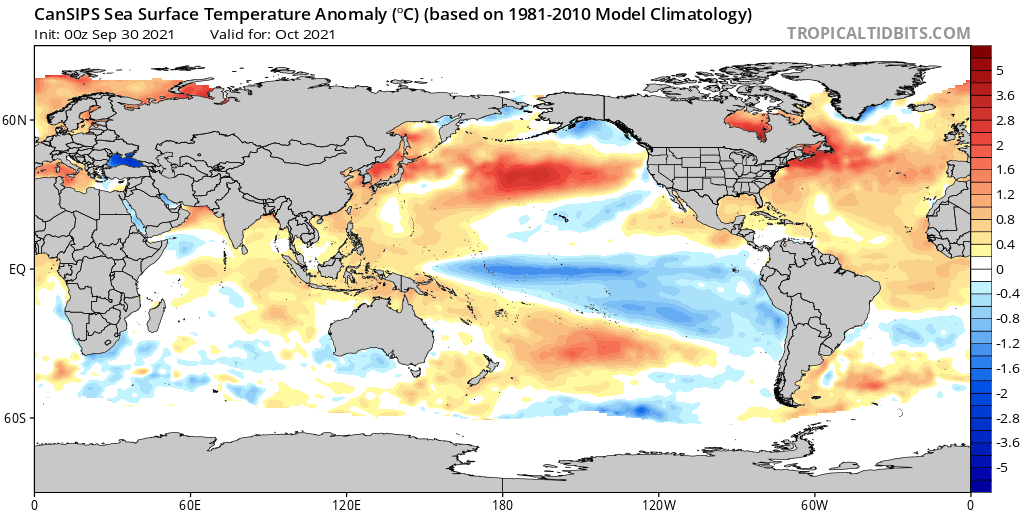
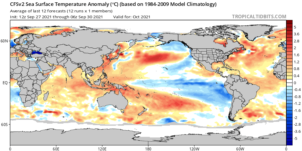
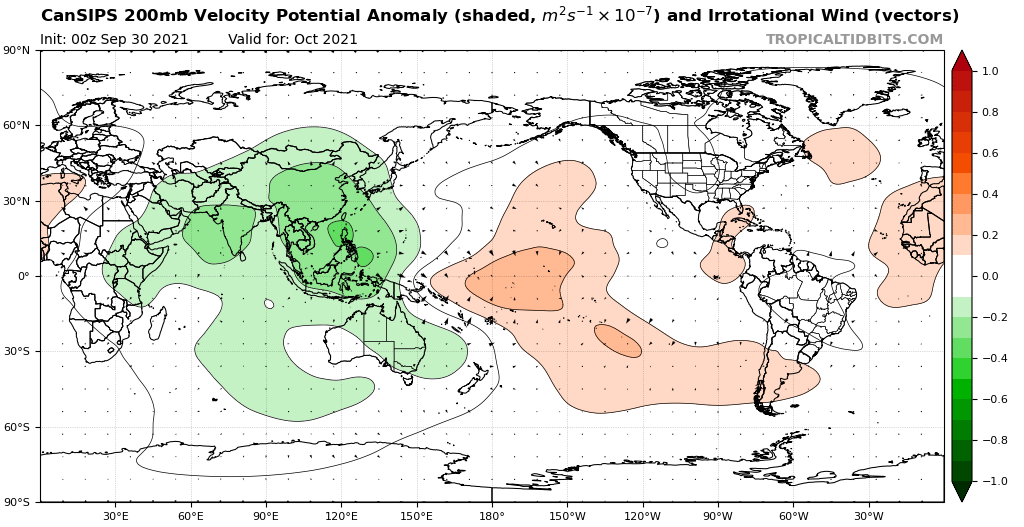
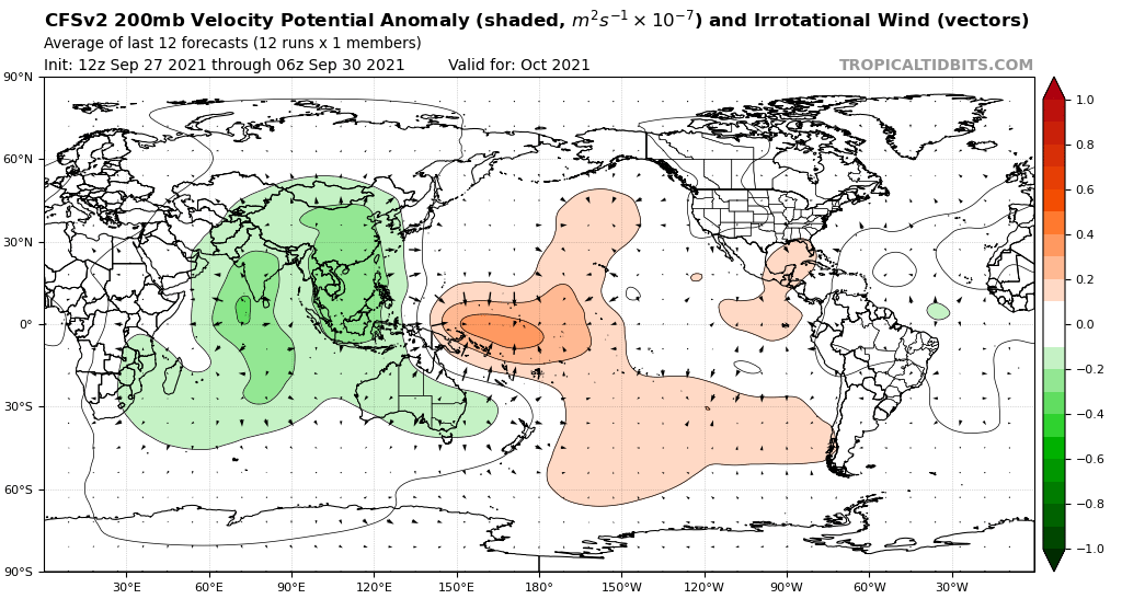
A true El Niño pattern during October typically leads to large-scale subsidence over the Maritime Continent and large-scale convergence over the central/eastern Pacific. 2021 does not appear like that at all, with the most persistent -VP200 anomalies near the Maritime Continent.
Image
5 likes   
NCSU B.S. in Meteorology Class of 2021. Tropical weather blogger at http://www.cyclonicfury.com. My forecasts and thoughts are NOT official, for official forecasts please consult the National Hurricane Center.

User avatar
WiscoWx02
Category 1
Category 1
Posts: 391
Joined: Sat Jul 31, 2021 8:09 pm

Re: 2021 Indicators: SST's / SAL / MSLP / Shear / Steering / Instability / Sat Images

#3787 Postby WiscoWx02 » Tue Oct 05, 2021 10:48 am

CyclonicFury wrote:I'd be shocked if we don't see another hurricane before the end of the season. The EPS and CFS both show a strong CCKW/MJO moving in to the Atlantic in the next 7-10 days, and the CFS and GEFS both show Caribbean shear relaxing during that time. Not to mention, there's always a possibility we get a hurricane of non-tropical origin in the subtropics, like Ophelia/Epsilon. 2021 has NOT behaved like an El Niño - the Atlantic has been much more active than the EPAC - even if shear maps suggest so. I don't expect the late season to be anything like last year but I'd be surprised if we don't see a final burst of activity.


God no it certainly has not behaved like an El Nino all year, we wouldn't have had another ridiculous season like we have, but it is now with the synoptic pattern we are in. Maybe I place too much importance in the synoptic scale idk, but as someone going to college in Minnesota...seeing this type of pattern we are in now is very El Nino like. Last year we had snow by now :lol:

Edit: active western Pacific more importantly is very El Nino like as well.
0 likes   

User avatar
Category5Kaiju
Category 5
Category 5
Posts: 4095
Joined: Thu Dec 24, 2020 12:45 pm
Location: Seattle

Re: 2021 Indicators: SST's / SAL / MSLP / Shear / Steering / Instability / Sat Images

#3788 Postby Category5Kaiju » Tue Oct 05, 2021 12:00 pm

A good example of a La Nina year that behaved like an El Nino is 2016, with an extremely active EPAC and WPAC. However, it did so because the super El Nino in 2015 was so strong that its effects basically lingered, so given 2021 is a second year La Nina following a solid, moderate La Nina, I just do not see how it has really behaved like an El Nino in any way. La Nina years can still have Atlantic shear and lulls, it's not unexpected for such to occur. With hurricanes like Ida and Sam happening especially, I'm pretty confident to say that this year was very La Nina-like and rightfully so.
6 likes   
Unless explicitly stated, all info in my posts is based on my own opinions and observations. Tropical storms and hurricanes can be extremely dangerous. Do not think you can beat Mother Nature. Refer to an accredited weather research agency or meteorologist if you need to make serious decisions regarding an approaching storm.

User avatar
CyclonicFury
Category 5
Category 5
Posts: 2025
Age: 26
Joined: Sun Jul 02, 2017 12:32 pm
Location: NC
Contact:

Re: 2021 Indicators: SST's / SAL / MSLP / Shear / Steering / Instability / Sat Images

#3789 Postby CyclonicFury » Tue Oct 05, 2021 12:05 pm

Category5Kaiju wrote:A good example of a La Nina year that behaved like an El Nino is 2016, with an extremely active EPAC and WPAC. However, it did so because the super El Nino in 2015 was so strong that its effects basically lingered, so given 2021 is a second year La Nina following a solid, moderate La Nina, I just do not see how it has really behaved like an El Nino in any way. La Nina years can still have Atlantic shear and lulls, it's not unexpected for such to occur. With hurricanes like Ida and Sam happening especially, I'm pretty confident to say that this year was very La Nina-like and rightfully so.

Even 2020 had some lulls late in the season. Nothing was active between September 24 and October 1. Nothing was active between October 11 and 18. This season most likely won't be nearly as active as last year, but I don't think the season is over yet from a meteorological standpoint. The lack of activity right now is likely related to the suppressed KW/MJO.
5 likes   
NCSU B.S. in Meteorology Class of 2021. Tropical weather blogger at http://www.cyclonicfury.com. My forecasts and thoughts are NOT official, for official forecasts please consult the National Hurricane Center.

User avatar
WiscoWx02
Category 1
Category 1
Posts: 391
Joined: Sat Jul 31, 2021 8:09 pm

Re: 2021 Indicators: SST's / SAL / MSLP / Shear / Steering / Instability / Sat Images

#3790 Postby WiscoWx02 » Tue Oct 05, 2021 12:39 pm

Category5Kaiju wrote:A good example of a La Nina year that behaved like an El Nino is 2016, with an extremely active EPAC and WPAC. However, it did so because the super El Nino in 2015 was so strong that its effects basically lingered, so given 2021 is a second year La Nina following a solid, moderate La Nina, I just do not see how it has really behaved like an El Nino in any way. La Nina years can still have Atlantic shear and lulls, it's not unexpected for such to occur. With hurricanes like Ida and Sam happening especially, I'm pretty confident to say that this year was very La Nina-like and rightfully so.


I get where you are coming from for sure, this year has been one of the biggest pains in the you know what since I started watching this stuff. One thorn in my discussion though if Michael I suppose, which formed in the Caribbean Sea in a El Nino year. I remember a monster cold snap that plunged our temps into the 20s up here that happened a week before Michael, which probably shaped the pressure patterns to aid the storm which essentially made the fact we were in an El Nino inconsequential with the aid of the Kelvin Wave as well. It really is all about right place at the right time. You get a killer trough that comes down from Canada lower the upper level pressures over the US, you're gonna see pressures raise with height over the tropics and thus encourage surface convergence. We had a lot of right places at the right time last year, idk, I've been bearish with this season at times since the beginning and have been proven wrong again and again so if this proves wrong.......I'll take it as a learning experience.
0 likes   

AlphaToOmega
Category 5
Category 5
Posts: 1448
Joined: Sat Jun 26, 2021 10:51 am
Location: Somewhere in Massachusetts

Re: 2021 Indicators: SST's / SAL / MSLP / Shear / Steering / Instability / Sat Images

#3791 Postby AlphaToOmega » Tue Oct 05, 2021 2:55 pm

Let us step back and look at the facts:

General pattern:
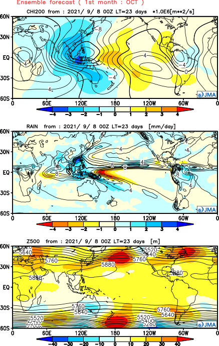
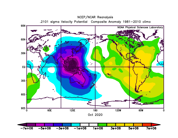
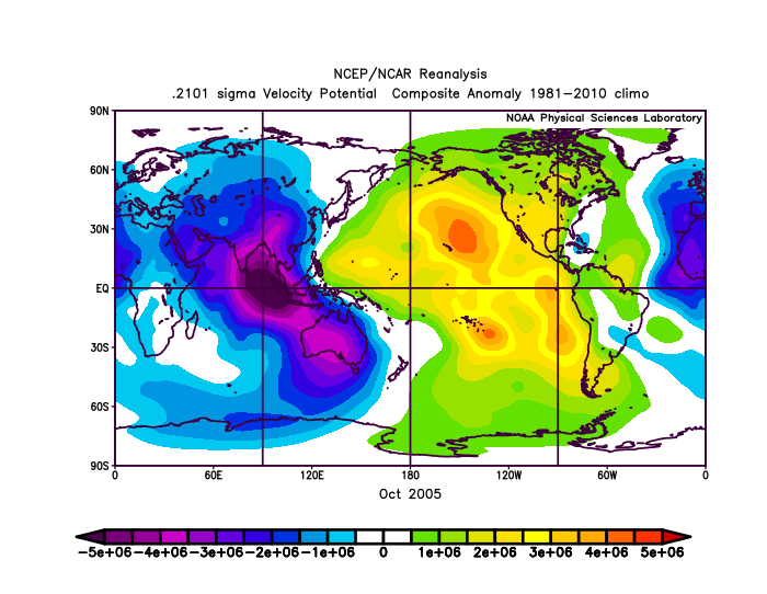
The general pattern for October 2021 is favorable. There are favorable SST and VP patterns present that are expected to continue later this month. In terms of SSTs, a negative PDO and a negative ENSO combined with a positive AMO and a positive TNA would support an active October. In terms of VP, negative VP over the Eastern Hemisphere and positive VP over the Western Hemisphere foster strong tropical waves, thus fostering an active hurricane season.

Image
Image

Image
Image
Image[/url]

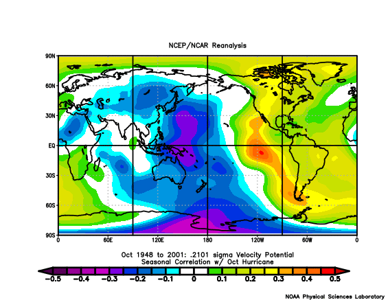
Some of the most active Octobers had similar VP patterns. Octobers of 2005 and 2020 had very similar VP patterns. In fact, rising air in the Eastern Hemisphere is directly correlated with Atlantic activity during October.

Image
Image

Image

Models:
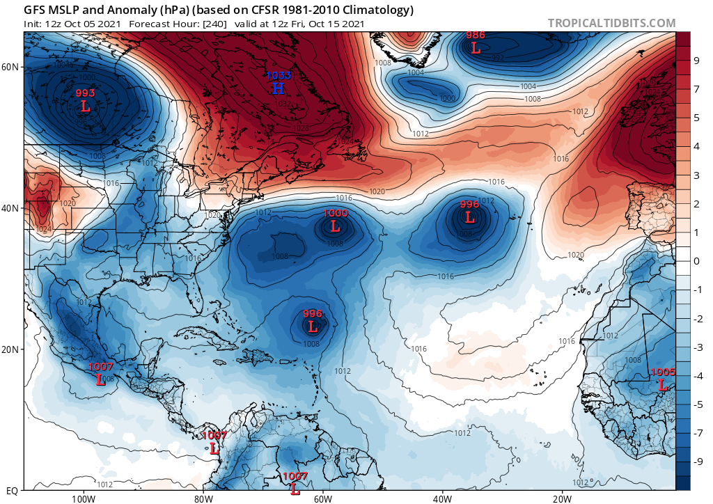
The GFS shows the 0/10 AoI in the Atlantic briefly developing near the Carolinas just like Danny (2021). Then it shows three cyclones developing, all of them going below the 990-millibar mark, which is probably indicative of a hurricane.

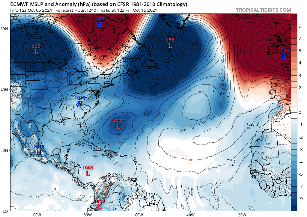
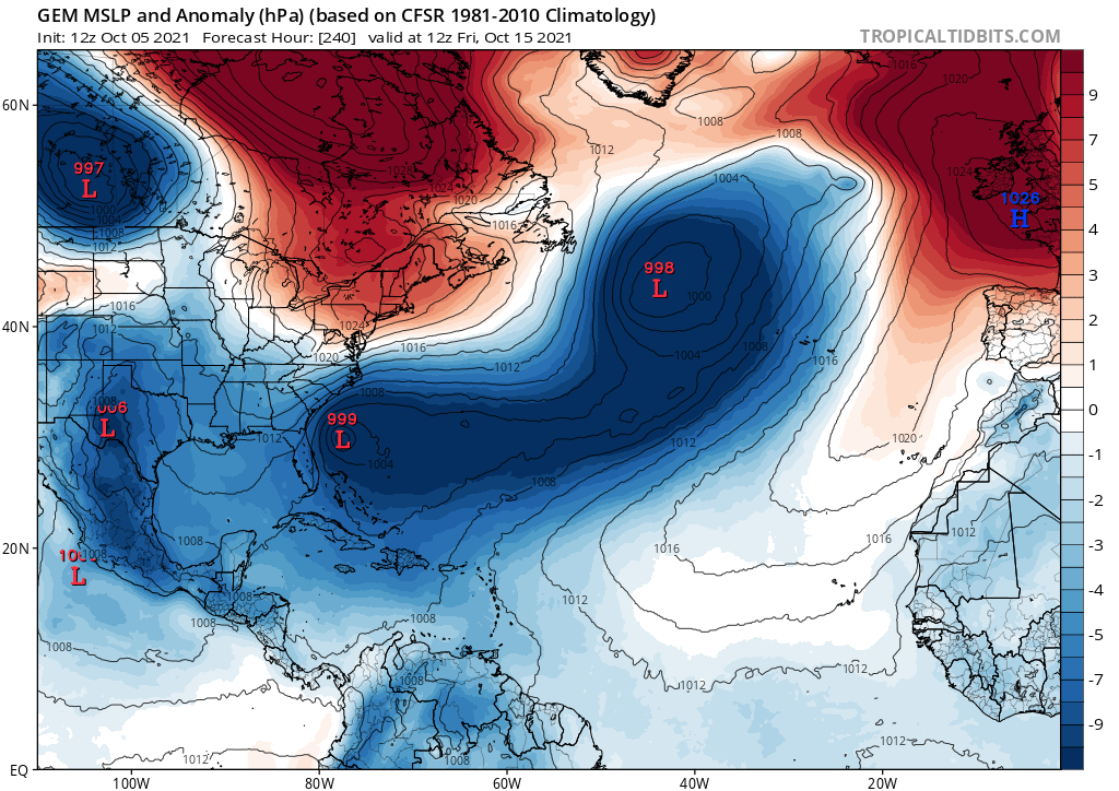
The CMC tries to develop the 0/10 AoI, but it also shows activity in the Atlantic come mid-October. The ECMWF concurs with the CMC.

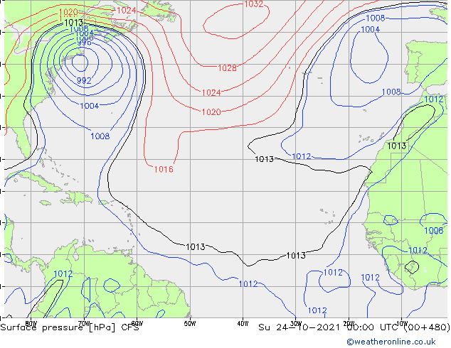
The CFSv2 concurs with the CFS. It shows the 0/10 AoI briefly developing, and then it shows the possibility of multiple storms forming. It then shows a possible tropical cyclone impacting the East Coast. Because of the low resolution of the CFSv2, it is difficult to identify the intensity of these systems.

While this should not be taken as gospel, it indicates that models are starting to notice favorable conditions in the Atlantic.

Image
Image
Image
Image

Based on all of this, it is very likely that 2021 features an active October just as 2020 and 2005 did.
Last edited by AlphaToOmega on Tue Oct 05, 2021 3:59 pm, edited 1 time in total.
4 likes   

User avatar
Hammy
Category 5
Category 5
Posts: 5849
Age: 41
Joined: Fri May 25, 2012 5:25 pm
Contact:

Re: 2021 Indicators: SST's / SAL / MSLP / Shear / Steering / Instability / Sat Images

#3792 Postby Hammy » Tue Oct 05, 2021 3:28 pm

:uarrow: I've generally been ignoring the GFS since early September--it's been persistently showing high levels of activity all season that never pan out.

CFS has continued trending towards more activity during later October and most of November, something it was hinting at off and on earlier in the season before the model lull showed up.

It's continuing to show a large, potentially subtropical (if not outright tropical) system around mid-month, originating from a frontal system, and should this play out I have a difficult time seeing it being entirely non-tropical for the duration as it'll be sitting over the Gulf stream for days.

At least three distinct storms are showing up in the Caribbean--one following the above system that heads towards the Bahamas, a stronger system in early November that goes into the Gulf, and a third in late November that spends a week or so in the Caribbean before apparently merging with a front as it heads north.

There is also a shorter lived low pressure in late October in the northeastern Gulf.

As a side note, for ease of use (and higher resolution, at least compared to the full Atlantic map), East Coast and Gulf maps can be found under the North America option, and the Caribbean under the Central America option.

The strongest of the three Caribbean systems:

Image
3 likes   
The above post is not official and should not be used as such. It is the opinion of the poster and may or may not be backed by sound meteorological data. It is not endorsed by any professional institution or storm2k.org. For official information, please refer to the NHC and NWS products.

User avatar
abajan
S2K Supporter
S2K Supporter
Posts: 4230
Joined: Sun Sep 07, 2003 5:10 am
Location: Barbados

Re: 2021 Indicators: SST's / SAL / MSLP / Shear / Steering / Instability / Sat Images

#3793 Postby abajan » Tue Oct 05, 2021 8:30 pm

[youtube]https://youtu.be/dm5lDQk8uvA[/youtube]
1 likes   

User avatar
WiscoWx02
Category 1
Category 1
Posts: 391
Joined: Sat Jul 31, 2021 8:09 pm

Re: 2021 Indicators: SST's / SAL / MSLP / Shear / Steering / Instability / Sat Images

#3794 Postby WiscoWx02 » Tue Oct 05, 2021 9:25 pm

Image

Kinda wanna take a step back and eliminate any doubt that my recent bearish predictions are in no way saying I thought this season was a bust, cause it sure as heck wasn't. When you stop and think about it, until this morning, we had nonstop activity since early August with Fred. August was just insane, with 2 major hurricanes, Grace and Ida, Ida of which caused horrendous impacts in Louisiana. Also had Henri, so taking a step back and looking at August alone....wow :eek: .

Then we had just an insane amount of named storms in September, sure, majority of them probably would never have been recognized 20-30 years ago, but Nicholas, Larry and Sam were sure as heck notable. Sam alone produced 53.8 units of ACE, which is just amazing. Sure was an underdog for a name that didn't start with "I".

Going back to June and July...Bill, Claudette, Danny and Elsa made that period almost nonstop, until mid July that is. Phil Klotzbach tweeted back when Elsa happened that hurricanes forming where Elsa did was an indicator of an active and destructive season based on other years such a thing had happened. That post certainly aged well I'd say for worse.

20 named storms, 7 hurricanes and 4 major hurricanes and 139.5 units of ACE later :double: ...now we wait to see IF October and November have anything in store. Y'all know my opinion by now, but I very well could be horribly wrong. Part of me is kinda hoping we reach that hyperactive status just for the heck of it from a hurricane that forms out in the middle of nowhere in the subtropics like Epsilon and is an ACE machine. We don't need any of the nonsense we had last year. If we do see something notable in the next 2 months, I think reaching the hyperactive benchmark is sure as heck possible.

Regardless of if we do or not...I think something we can ALL agree on was that this season up this point is one we will never forget. Nowhere near as notable as 2020 or 2005.....but it has found a spot next to 2012, 2008, 1999, 1996, 2003 and 2011 in my books.
1 likes   

User avatar
Category5Kaiju
Category 5
Category 5
Posts: 4095
Joined: Thu Dec 24, 2020 12:45 pm
Location: Seattle

Re: 2021 Indicators: SST's / SAL / MSLP / Shear / Steering / Instability / Sat Images

#3795 Postby Category5Kaiju » Tue Oct 05, 2021 9:34 pm

Also it's a pretty general statement, but I think we should all still keep in mind in the back of our heads that there are indeed a decent number of solid La Nina years that have featured major, impactful hurricanes after mid-October. Examples include 1921, 1926, 1932, 1944, 1950, 1988, 1998, 1999, 2001, 2005, 2008, 2012, and 2020. Seeing major hurricanes during that timeframe is quite common in certain La Nina years, and given how this year has behaved so far with its tremendous booms during favorable CCKWs/MJO and deathly silence during unfavorable CCKWs/MJO, I would not be surprised to see a fifth major hurricane occur after October 15, after what should be a favorable rising motion phase. Now where will it be? Idk, but given how thermodynamically favorable the West Atlantic looks as of now, it certainly cannot be ruled out that activity may be primed in that area once the Atlantic experiences that favorable rising motion pass in several weeks.
5 likes   
Unless explicitly stated, all info in my posts is based on my own opinions and observations. Tropical storms and hurricanes can be extremely dangerous. Do not think you can beat Mother Nature. Refer to an accredited weather research agency or meteorologist if you need to make serious decisions regarding an approaching storm.

User avatar
WiscoWx02
Category 1
Category 1
Posts: 391
Joined: Sat Jul 31, 2021 8:09 pm

Re: 2021 Indicators: SST's / SAL / MSLP / Shear / Steering / Instability / Sat Images

#3796 Postby WiscoWx02 » Tue Oct 05, 2021 9:47 pm

Category5Kaiju wrote:Also it's a pretty general statement, but I think we should all still keep in mind in the back of our heads that there are indeed a decent number of solid La Nina years that have featured major, impactful hurricanes after mid-October. Examples include 1921, 1926, 1932, 1944, 1950, 1988, 1998, 1999, 2001, 2005, 2008, 2012, and 2020. Seeing major hurricanes during that timeframe is quite common in certain La Nina years, and given how this year has behaved so far with its tremendous booms during favorable CCKWs/MJO and deathly silence during unfavorable CCKWs/MJO, I would not be surprised to see a fifth major hurricane occur after October 15, after what should be a favorable rising motion phase. Now where will it be? Idk, but given how thermodynamically favorable the West Atlantic looks as of now, it certainly cannot be ruled out that activity may be primed in that area once the Atlantic experiences that favorable rising motion pass in several weeks.


If it does, I'm hoping for either a Ophelia (2017), Epsilon (2020, 2005) or any other hurricane that just messed around out in the middle of no where. No Delta, Zeta, Eta, Iota, Wilma, Michael, Opal, Sandy etc repeats please 8-)
0 likes   

User avatar
InfernoFlameCat
Category 5
Category 5
Posts: 2102
Age: 22
Joined: Mon Dec 14, 2020 10:52 am
Location: Buford, GA

Re: 2021 Indicators: SST's / SAL / MSLP / Shear / Steering / Instability / Sat Images

#3797 Postby InfernoFlameCat » Tue Oct 05, 2021 11:29 pm

WiscoWx02 wrote:
Category5Kaiju wrote:Also it's a pretty general statement, but I think we should all still keep in mind in the back of our heads that there are indeed a decent number of solid La Nina years that have featured major, impactful hurricanes after mid-October. Examples include 1921, 1926, 1932, 1944, 1950, 1988, 1998, 1999, 2001, 2005, 2008, 2012, and 2020. Seeing major hurricanes during that timeframe is quite common in certain La Nina years, and given how this year has behaved so far with its tremendous booms during favorable CCKWs/MJO and deathly silence during unfavorable CCKWs/MJO, I would not be surprised to see a fifth major hurricane occur after October 15, after what should be a favorable rising motion phase. Now where will it be? Idk, but given how thermodynamically favorable the West Atlantic looks as of now, it certainly cannot be ruled out that activity may be primed in that area once the Atlantic experiences that favorable rising motion pass in several weeks.


If it does, I'm hoping for either a Ophelia (2017), Epsilon (2020, 2005) or any other hurricane that just messed around out in the middle of no where. No Delta, Zeta, Eta, Iota, Wilma, Michael, Opal, Sandy etc repeats please 8-)

I would like a Wilma that bombs down in the 880s again. Just one that does so safely.
0 likes   
I am by no means a professional. DO NOT look at my forecasts for official information or make decisions based on what I post.

Goal: to become a registered expert over tropical and subtropical cyclones.

AxaltaRacing24
Category 5
Category 5
Posts: 1753
Age: 25
Joined: Wed Jul 27, 2016 11:14 am
Location: Jupiter, FL

Re: 2021 Indicators: SST's / SAL / MSLP / Shear / Steering / Instability / Sat Images

#3798 Postby AxaltaRacing24 » Wed Oct 06, 2021 1:56 am

It might not be a 2020 repeat, but we are going to see some storms down there at some point.
0 likes   

User avatar
aspen
Category 5
Category 5
Posts: 8818
Joined: Sat Oct 12, 2019 7:10 pm
Location: Connecticut, USA

Re: 2021 Indicators: SST's / SAL / MSLP / Shear / Steering / Instability / Sat Images

#3799 Postby aspen » Wed Oct 06, 2021 6:26 am

The Omar-like system popped up again on the 00z, and also appears on the 06z run, although it’s weaker. It stalls out in the middle of the Atlantic for a bit on the 00z run.
0 likes   
Irene '11 Sandy '12 Hermine '16 5/15/2018 Derecho Fay '20 Isaias '20 Elsa '21 Henri '21 Ida '21

I am only a meteorology enthusiast who knows a decent amount about tropical cyclones. Look to the professional mets, the NHC, or your local weather office for the best information.

User avatar
Category5Kaiju
Category 5
Category 5
Posts: 4095
Joined: Thu Dec 24, 2020 12:45 pm
Location: Seattle

Re: 2021 Indicators: SST's / SAL / MSLP / Shear / Steering / Instability / Sat Images

#3800 Postby Category5Kaiju » Wed Oct 06, 2021 7:20 am

aspen wrote:The Omar-like system popped up again on the 00z, and also appears on the 06z run, although it’s weaker. It stalls out in the middle of the Atlantic for a bit on the 00z run.


Omar-like? The way I am seeing that system it looks like it develops in the MDR and just takes a very sharp recurve; Omar in 2008 started in the ECAR and went NE (a less extreme version of Lenny). Idk I could be wrong, but at least the path that that storm is taking does not seem to be like Omar's.

 https://twitter.com/AndyHazelton/status/1445423564556062722


Maybe this is the culprit?
0 likes   
Unless explicitly stated, all info in my posts is based on my own opinions and observations. Tropical storms and hurricanes can be extremely dangerous. Do not think you can beat Mother Nature. Refer to an accredited weather research agency or meteorologist if you need to make serious decisions regarding an approaching storm.


Return to “Talkin' Tropics”

Who is online

Users browsing this forum: ElectricStorm, Google Adsense [Bot], hurricanes1234, IsabelaWeather and 40 guests