https://ftp.nhc.noaa.gov/atcf/btk/
ATL: INVEST 92L - Discussion
Moderator: S2k Moderators
ATL: INVEST 92L - Discussion
AL, 92, 2021100706, , BEST, 0, 310N, 793W, 20, 1016, DB, 34, NEQ, 0, 0, 0, 0, 1018, 120, 90, 0, 0, L, 0, , 0, 0, INVEST, S, 0, , 0, 0, 0, 0, genesis-num, 044,
https://ftp.nhc.noaa.gov/atcf/btk/
1 likes
-
Sciencerocks
- Category 5

- Posts: 10186
- Age: 40
- Joined: Thu Jul 06, 2017 1:51 am
Re: ATL: INVEST 92L - Discussion
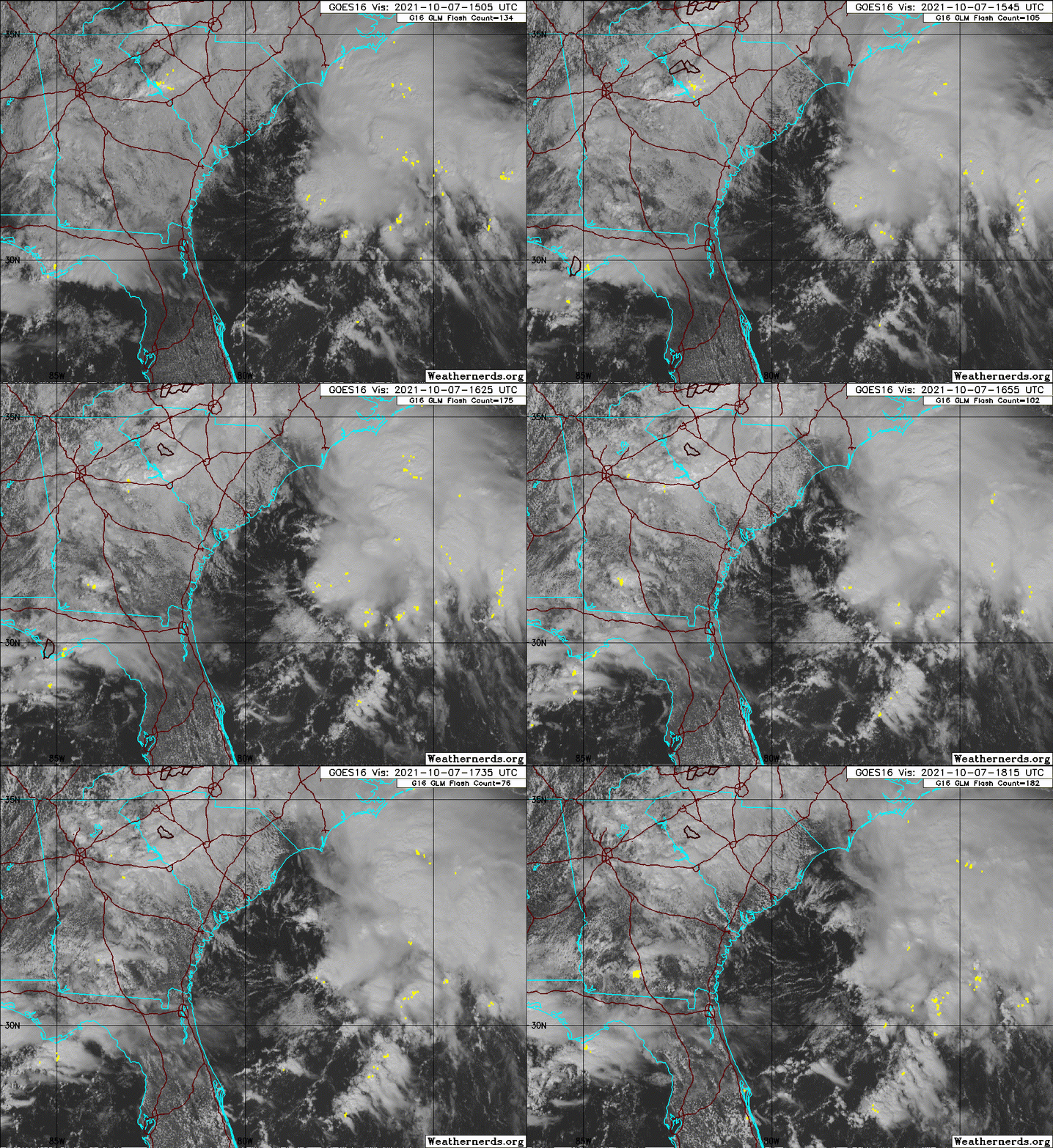
Certainly is pumping humidity into EC NC today.
0 likes
I'm not a meteorologist, I'm an electronics engineer. While I can probably fix your toaster oven, you're not going to learn about storms from me!
New Mexico had no hurricanes. Then I moved to NC right before Fran.....
New Mexico had no hurricanes. Then I moved to NC right before Fran.....
- HurricaneEnzo
- Category 2

- Posts: 744
- Joined: Wed Mar 14, 2018 12:18 pm
- Location: Newport, NC (Hurricane Alley)
Re: ATL: INVEST 92L - Discussion
If they named Odette this should at least have a decent chance of being a TD or something. Looks as good or maybe slightly better than Ode with a small area of 30kts winds. Needs to persist longer though that will be the key.
3 likes
Bertha 96' - Fran 96' - Bonnie 98' - Dennis 99' - Floyd 99' - Isabel 03' - Alex 04' - Ophelia 05' - Irene 11' - Arthur 14' - Matthew 16' - Florence 18' - Dorian 19' - Isaias 20' (countless other tropical storms and Hurricane swipes)
I am not a Professional Met just an enthusiast. Get your weather forecasts from the Pros!
I am not a Professional Met just an enthusiast. Get your weather forecasts from the Pros!
-
MarioProtVI
- Category 5

- Posts: 1034
- Age: 24
- Joined: Sun Sep 29, 2019 7:33 pm
- Location: New Jersey
Re: ATL: INVEST 92L - Discussion
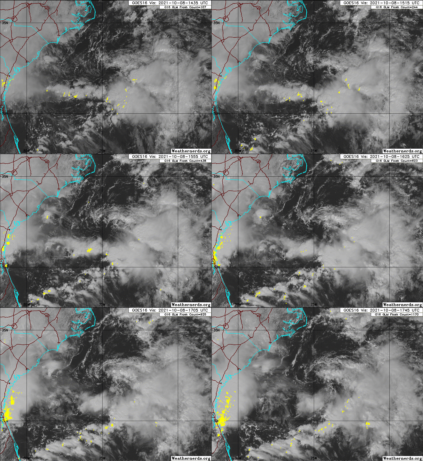
Visible imagery suggests a far different picture then ASCAT. Looks extremely broad and ill-defined with no clear center. Not sold at all on this developing.
0 likes
-
Sciencerocks
- Category 5

- Posts: 10186
- Age: 40
- Joined: Thu Jul 06, 2017 1:51 am
-
OuterBanker
- S2K Supporter

- Posts: 1761
- Joined: Wed Feb 26, 2003 10:53 am
- Location: Nags Head, NC
- Contact:
Re: ATL: INVEST 92L - Discussion
This thing has been meandering for what seems like forever. A naked swirl where upper level winds have decimated its chances. There could be a brief period between the shear zones in which something could spin something up. All models are showing heavy rains and near tropical storm winds on the OBX tomorrow. Whatever happens it will be something of a hybrid and will probably not get named. It would be nice to end the name list this weekend.
0 likes
Re: ATL: INVEST 92L - Discussion
2 PM Tropical Weather Outlook:
Satellite images and surface observations indicate that the low
pressure system located a couple of hundred miles east of the coast
of South Carolina is gradually becoming better defined. Although
the associated shower and thunderstorm activity is currently
disorganized, environmental conditions could briefly become
marginally conducive for the low to acquire subtropical
characteristics by Saturday night and early Sunday. By early next
week, the low is expected to interact with a frontal boundary,
which should end the opportunity for any subtropical or tropical
formation. The low is forecast to meander offshore the Carolinas
today, and then slowly move back toward the west-northwest and
northwest on Saturday, bringing the system closer to the coast of
North Carolina. Interests along the coast of North and South
Carolina should monitor the progress of this system. Regardless of
development, intermittent periods of locally heavy rains and gusty
winds will affect eastern portions of the Carolinas through the
weekend. An Air Force Reserve reconnaissance aircraft is scheduled
to investigate the system Saturday afternoon, if necessary.
* Formation chance through 48 hours...medium...40 percent.
* Formation chance through 5 days...medium...40 percent.
0 likes
-
Sciencerocks
- Category 5

- Posts: 10186
- Age: 40
- Joined: Thu Jul 06, 2017 1:51 am
Re: ATL: INVEST 92L - Discussion
I definitely has a short window until 0z Monday to do something.
0 likes
Re: ATL: INVEST 92L - Discussion

1 likes
Kendall -> SLO -> PBC
Memorable Storms: Katrina (for its Florida landfall...) Wilma Matthew Irma
Memorable Storms: Katrina (for its Florida landfall...) Wilma Matthew Irma
Re: ATL: INVEST 92L - Discussion
Tropical Weather Outlook
NWS National Hurricane Center Miami FL
800 AM EDT Sat Oct 9 2021
For the North Atlantic...Caribbean Sea and the Gulf of Mexico:
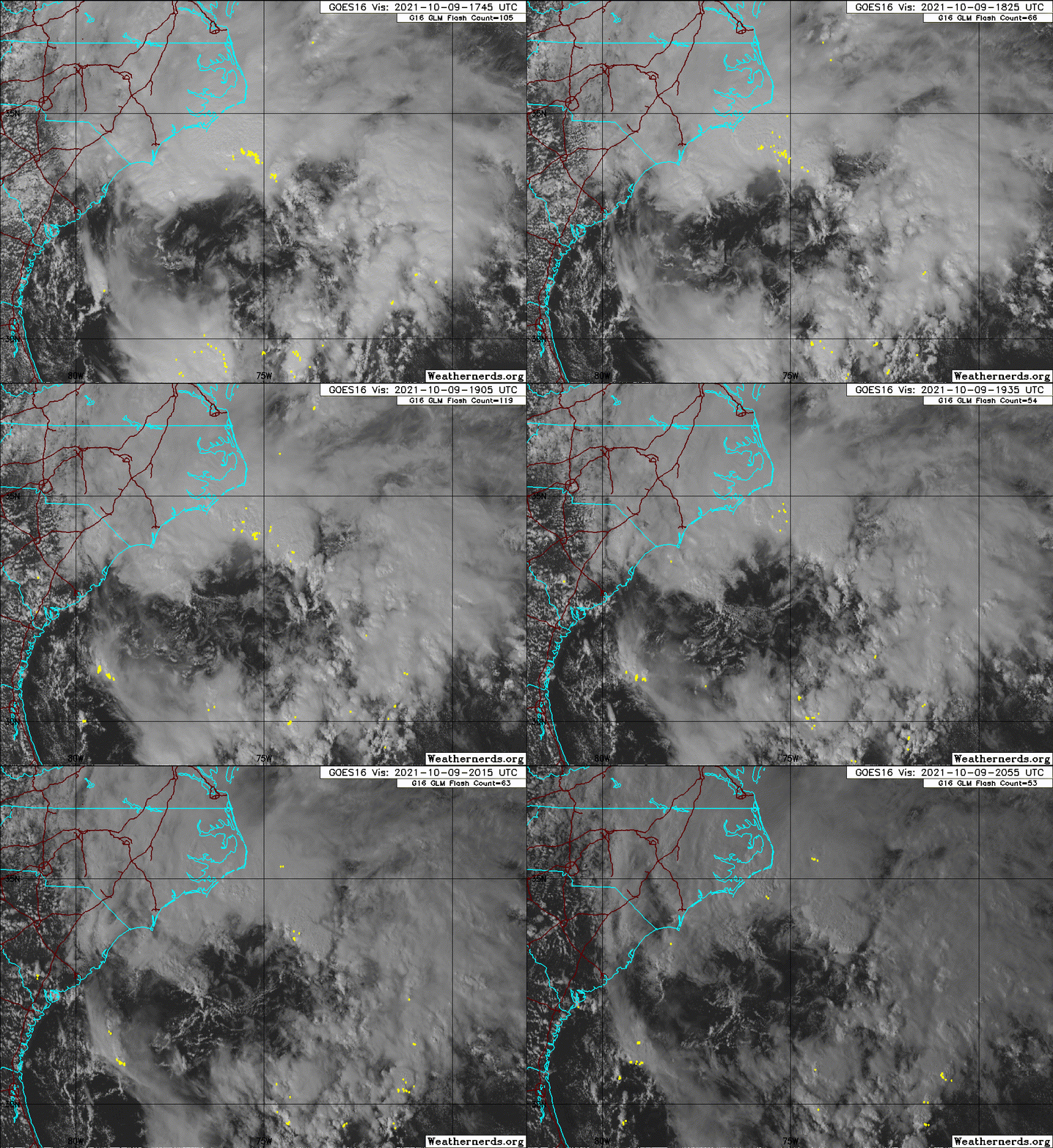
A well-defined, non-tropical low pressure system located about 200
miles southeast of Morehead City and Wilmington, North Carolina,
continues to produce a large area of cloudiness and disorganized
showers and thunderstorms. Environmental conditions could briefly
become marginally conducive for the low to acquire subtropical
characteristics through early Sunday. However, by late Sunday and
Monday, environmental conditions should become unfavorable for any
further development. The low is forecast to move slowly
northwestward during the next day or so, and approach the North
Carolina coast tonight and early Sunday. Therefore, interests along
the North Carolina coast should monitor the progress of this
system.
Regardless of development, intermittent periods of locally heavy
rains and gusty winds will affect southeastern and eastern portions
of North Carolina during the next day or two. An Air Force Reserve
reconnaissance aircraft is scheduled to investigate the low this
afternoon. Additional information on this system, including gale
warnings, can be found in High Seas Forecasts issued by the National
Weather Service.
* Formation chance through 48 hours...medium...40 percent.
* Formation chance through 5 days...medium...40 percent.
&&
High Seas Forecasts issued by the National Weather Service
can be found under AWIPS header NFDHSFAT1, WMO header FZNT01
KWBC, and online at ocean.weather.gov/shtml/NFDHSFAT1.php
$$
Forecaster Stewart
0 likes
Re: ATL: INVEST 92L - Discussion
The possibility of sub-tropical development seems to be improving


0 likes
Re: ATL: INVEST 92L - Discussion
The GFS has been insisting on a convective burst tonight working its way to surface and driving pressure falls -> TCG. The 12z run doubles down and brings this down to 996. Might be overdoing it but the mesoscale models have a similar progression.

Not long after, upper level winds shear the cloud tops away leading to weakening and multiple vorts. Would be another "shortie"

Not long after, upper level winds shear the cloud tops away leading to weakening and multiple vorts. Would be another "shortie"
0 likes
Kendall -> SLO -> PBC
Memorable Storms: Katrina (for its Florida landfall...) Wilma Matthew Irma
Memorable Storms: Katrina (for its Florida landfall...) Wilma Matthew Irma
Re: ATL: INVEST 92L - Discussion
@BigJoeBastardi
How is this non tropical? Its over 83 degree water and has been tracked out of the tropics for 7 days for goodness sakes, anyone want to bet the 1000-500 thk is not warmed at the center vs surroundings give pressure falls.
{…}
It makes no sense. If its well defined it means the pressures at the center alone given the upper pattern with the trough away from it has to make it warmer at the center. Why is that even a mention? You want to name ANA and Bob and not this? over colder water earlier?
It is mostly baroclinic forcing and tropical on the side. Hence a sub-tropical system at best. I am not sure what he is angry about other than the larger issues and the position in which he takes that are clearly mistaken. Sad to see. Looks like mainly a northeaster to me, with a twist of tropical

0 likes
Re: ATL: INVEST 92L - Discussion
Any truth to the rumor that Joe was spotted in Vegas betting the "over" on exhausting this year's standard name list? J/K of course  Perhaps Joe's ire stems from some deep-seeded belief that NHC forecasters now receive "commission" for naming tropical storms? Hey, there are times when I shake my head thinking ".... whelp, that should never have been named" LOL! Of course the realty is that NHC (and Joe) ARE professionals and simply differ on which set of facts need be considered (or dismissed) as they apply to T.D. or T.S. classification.
The only takeaway from Bastardi's rant that I could agree with, is "You wanted to name Ana & Bob...." ? (but THAT Chupacabra or horse has been long beaten dead already).
The only takeaway from Bastardi's rant that I could agree with, is "You wanted to name Ana & Bob...." ? (but THAT Chupacabra or horse has been long beaten dead already).
1 likes
Andy D
(For official information, please refer to the NHC and NWS products.)
(For official information, please refer to the NHC and NWS products.)
-
Sciencerocks
- Category 5

- Posts: 10186
- Age: 40
- Joined: Thu Jul 06, 2017 1:51 am
Re: ATL: INVEST 92L - Discussion
Recon has the winds, and the things seem to be consolidating due south of Hatteras. It probably should be an STS
0 likes
Who is online
Users browsing this forum: No registered users and 39 guests


