Moderator: S2k Moderators


SFLcane wrote:I for one in my personal opinion think the season is over for conus and Florida. Maybe something weak subtropical in nature which is always possible this time of the yr in the Caribbean.
Other then that smooth sailing till 2022


psyclone wrote:SFLcane wrote:I for one in my personal opinion think the season is over for conus and Florida. Maybe something weak subtropical in nature which is always possible this time of the yr in the Caribbean.
Other then that smooth sailing till 2022
I agree and the writing has been on the wall for awhile now. I never would have imagined that Ida would have been our only major US impact this year but that appears now likely. At this point, If we get a storm in the caribbean it is vastly more likely to either move into central america or slip by to the east like Michelle in 2001. No one seems to stick around to do a late "season over" type post...they just depart the scene which has largely already happened. Now if it could just cool off...

aspen wrote:Hammy wrote:Teban54 wrote:A bit off-topic, but yet another reminder of how unrealistic the GFS' modelling of cold fronts can be:
https://twitter.com/burgwx/status/1446659795298263044?s=20
This is a long term problem with the GFS and has become a horrendous false advertiser during winter with cold weather or snow. With this large of an error, it would have significant implications regarding the shear levels in the Caribbean and East Coast, likely not being as favorable as it shows.
Wouldn’t a huge, deep cold front like the ones the GFS constantly shows increase the shear over the Caribbean instead of lowering it?

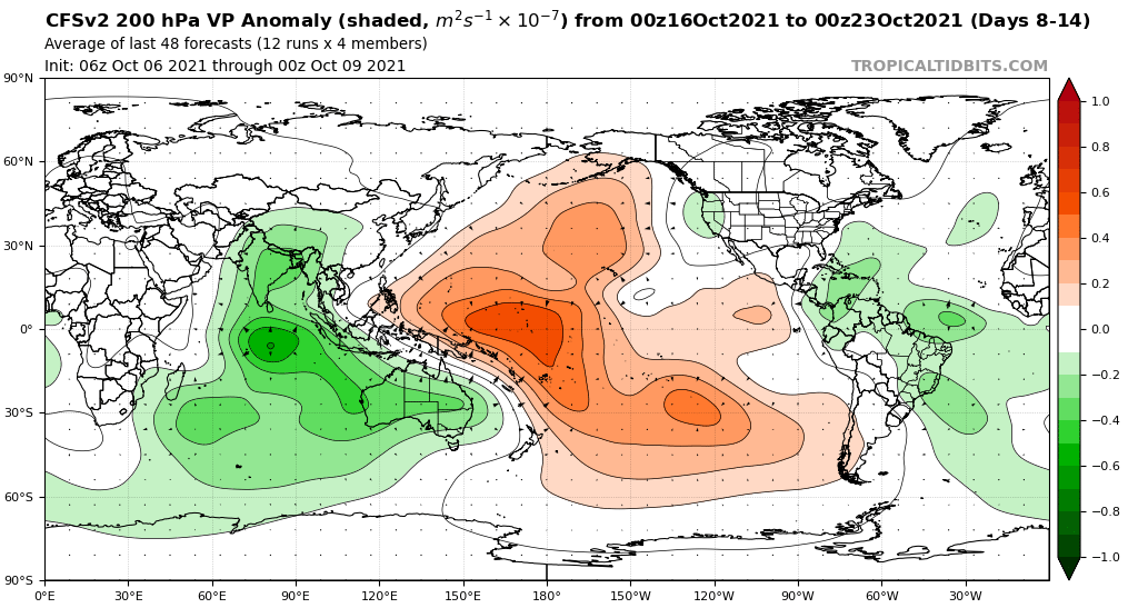
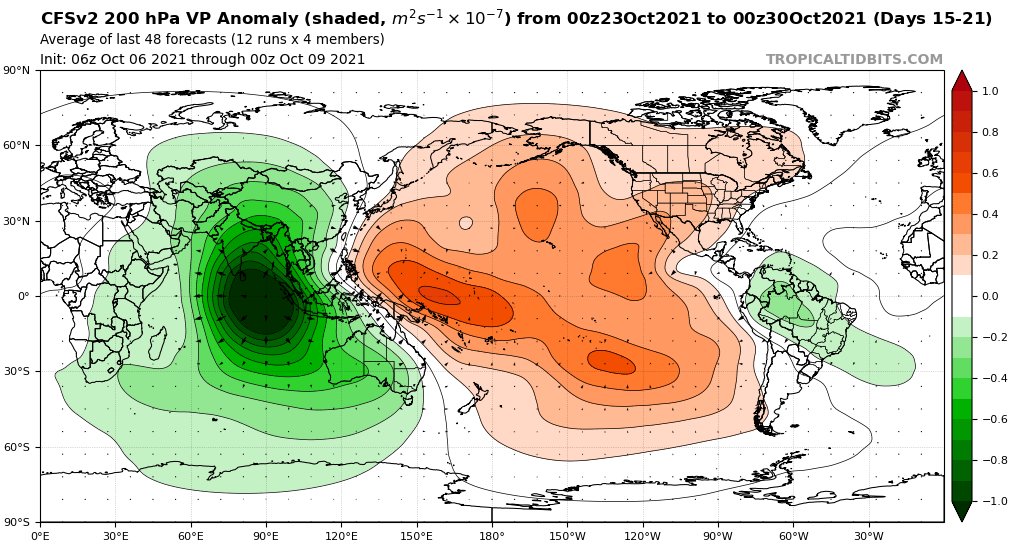
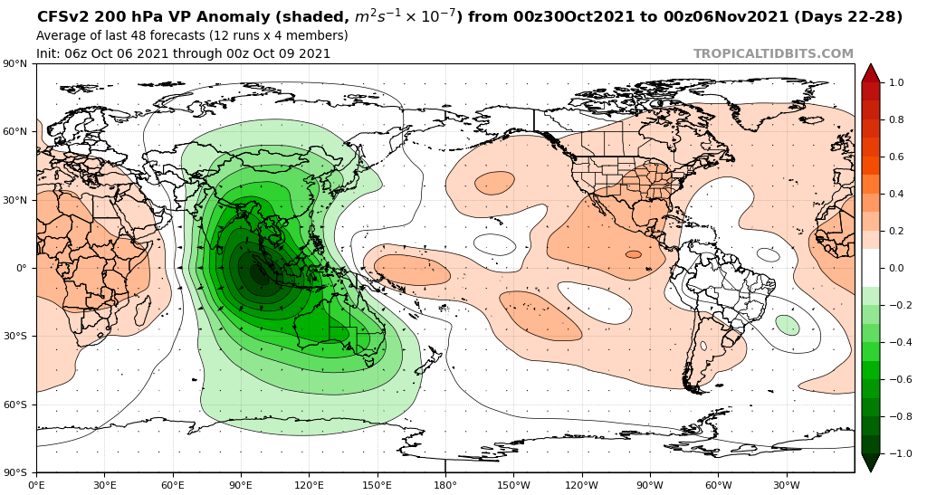
AlphaToOmega wrote:Based on CFSv2 and EPS guidance, it seems like we could have a sustained burst of activity from mid-October to November. Just like August and somewhat like September, October could be another very busy month in terms of activity and in terms of impacts.
https://i.postimg.cc/Pf6mWc8G/cfs-avg-chi200-Mean-global-2.png
https://i.postimg.cc/m2t78wQP/cfs-avg-chi200-Mean-global-3.png
https://i.postimg.cc/SN3C5MrD/cfs-avg-chi200-Mean-global-4.png
CyclonicFury wrote:AlphaToOmega wrote:Based on CFSv2 and EPS guidance, it seems like we could have a sustained burst of activity from mid-October to November. Just like August and somewhat like September, October could be another very busy month in terms of activity and in terms of impacts.
https://i.postimg.cc/Pf6mWc8G/cfs-avg-chi200-Mean-global-2.png
https://i.postimg.cc/m2t78wQP/cfs-avg-chi200-Mean-global-3.png
https://i.postimg.cc/SN3C5MrD/cfs-avg-chi200-Mean-global-4.png
I'm just not seeing support for a burst in mid-October anymore. The ensembles are awfully dead for the next 2 weeks which would take us into late October. Although the operational ECMWF struggled with the Caribbean genesis last year, the EPS usually had a signal well in advance. 92L could become a weak, short lived Wanda, but aside from that, it appears as if the quiet period will continue for at least another week.
You were right about September, but it definitely seems to be trending towards a much less active Caribbean late season than I was anticipating. We could still see something late in the month, but our chances of a strong Caribbean hurricane decrease each day.
MarioProtVI wrote:CyclonicFury wrote:AlphaToOmega wrote:Based on CFSv2 and EPS guidance, it seems like we could have a sustained burst of activity from mid-October to November. Just like August and somewhat like September, October could be another very busy month in terms of activity and in terms of impacts.
https://i.postimg.cc/Pf6mWc8G/cfs-avg-chi200-Mean-global-2.png
https://i.postimg.cc/m2t78wQP/cfs-avg-chi200-Mean-global-3.png
https://i.postimg.cc/SN3C5MrD/cfs-avg-chi200-Mean-global-4.png
I'm just not seeing support for a burst in mid-October anymore. The ensembles are awfully dead for the next 2 weeks which would take us into late October. Although the operational ECMWF struggled with the Caribbean genesis last year, the EPS usually had a signal well in advance. 92L could become a weak, short lived Wanda, but aside from that, it appears as if the quiet period will continue for at least another week.
You were right about September, but it definitely seems to be trending towards a much less active Caribbean late season than I was anticipating. We could still see something late in the month, but our chances of a strong Caribbean hurricane decrease each day.
Models didn’t see an active August like we had so the signal is likely refusing to show since it has been shown to struggle with MJO/CCKW progression, which I think is what is happening here.
Category5Kaiju wrote:MarioProtVI wrote:CyclonicFury wrote:I'm just not seeing support for a burst in mid-October anymore. The ensembles are awfully dead for the next 2 weeks which would take us into late October. Although the operational ECMWF struggled with the Caribbean genesis last year, the EPS usually had a signal well in advance. 92L could become a weak, short lived Wanda, but aside from that, it appears as if the quiet period will continue for at least another week.
You were right about September, but it definitely seems to be trending towards a much less active Caribbean late season than I was anticipating. We could still see something late in the month, but our chances of a strong Caribbean hurricane decrease each day.
Models didn’t see an active August like we had so the signal is likely refusing to show since it has been shown to struggle with MJO/CCKW progression, which I think is what is happening here.
Yeah honestly you make a pretty good point here; I remember these kinds of discussions in the indicators thread in August before Fred and Grace really showed off their true mights as the models kept showing stuff in the EPAC/WPAC but not in the Atlantic in the near future; it seems to me that once again the models are "bootlicking" the EPAC while turning a cold eye toward the Atlantic as they think the EPAC is going to produce more storms after Pamela later this month. Unless, we get some weird sort of "La Nino" pattern that suddenly favors the EPAC and shuts down the Atlantic for the rest of the season and leaves me scratching my head for eternity
MarioProtVI wrote:CyclonicFury wrote:AlphaToOmega wrote:Based on CFSv2 and EPS guidance, it seems like we could have a sustained burst of activity from mid-October to November. Just like August and somewhat like September, October could be another very busy month in terms of activity and in terms of impacts.
https://i.postimg.cc/Pf6mWc8G/cfs-avg-chi200-Mean-global-2.png
https://i.postimg.cc/m2t78wQP/cfs-avg-chi200-Mean-global-3.png
https://i.postimg.cc/SN3C5MrD/cfs-avg-chi200-Mean-global-4.png
I'm just not seeing support for a burst in mid-October anymore. The ensembles are awfully dead for the next 2 weeks which would take us into late October. Although the operational ECMWF struggled with the Caribbean genesis last year, the EPS usually had a signal well in advance. 92L could become a weak, short lived Wanda, but aside from that, it appears as if the quiet period will continue for at least another week.
You were right about September, but it definitely seems to be trending towards a much less active Caribbean late season than I was anticipating. We could still see something late in the month, but our chances of a strong Caribbean hurricane decrease each day.
Models didn’t see an active August like we had so the signal is likely refusing to show since it has been shown to struggle with MJO/CCKW progression, which I think is what is happening here.


CyclonicFury wrote:I'm just not seeing support for a burst in mid-October anymore. The ensembles are awfully dead for the next 2 weeks which would take us into late October.
Hammy wrote:Despite the intensity backoff compared to last week, the CFS still shows two systems in the Caribbean--one in middle and one in late October, along with some intermittent MDR development and a Gulf system that is on and off of the model. So that seems to further support the GFS not correctly reading where the more favorable conditions are farther out.
Users browsing this forum: No registered users and 388 guests


