ATL: INVEST 92L - Discussion
Moderator: S2k Moderators

Re: ATL: INVEST 92L - Discussion
Probably only has another six hours or so before conditions deteriorate. More than likely if it's not upgraded at 11, it won't be.
1 likes
The above post is not official and should not be used as such. It is the opinion of the poster and may or may not be backed by sound meteorological data. It is not endorsed by any professional institution or storm2k.org. For official information, please refer to the NHC and NWS products.

Re: ATL: INVEST 92L - Discussion
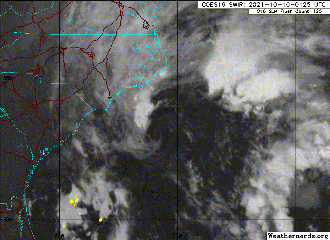
Shear from the south, doesn't look like the North Carolina Hurricane of 1857.
0 likes
-
InfernoFlameCat

- Category 5

- Posts: 2127
- Age: 22
- Joined: Mon Dec 14, 2020 10:52 am
- Location: Buford, GA
Re: ATL: INVEST 92L - Discussion
This guy fits sub-subtropical classification. Very close to actual classification IMO.
0 likes
I am by no means a professional. DO NOT look at my forecasts for official information or make decisions based on what I post.
Goal: to become a registered expert over tropical and subtropical cyclones.
Goal: to become a registered expert over tropical and subtropical cyclones.

Re: ATL: INVEST 92L - Discussion
Pretty big improvement since recon left (just before the start of this loop). Vortex does not look quite as elongated... next flight is tasked for tomorrow morning.
2 likes
Kendall -> SLO -> PBC
Memorable Storms: Katrina (for its Florida landfall...) Wilma Matthew Irma
Memorable Storms: Katrina (for its Florida landfall...) Wilma Matthew Irma
-
Sciencerocks
- Category 5
- Posts: 10186
- Age: 40
- Joined: Thu Jul 06, 2017 1:51 am
-
MarioProtVI
- Category 5
- Posts: 1034
- Age: 24
- Joined: Sun Sep 29, 2019 7:33 pm
- Location: New Jersey
Re: ATL: INVEST 92L - Discussion
Still looks very broad and disorganized - the “center” seen in nighttime vis is a swirl that is rotating around a broader low not well-defined enough for classification. Conditions already deteriorating for development as evident by the shearing of convection attempting to fire near the broad center, and shear should only increase further throughout today capping development. Chances should go down later this morning.
0 likes
Re: ATL: INVEST 92L - Discussion
MarioProtVI wrote:Still looks very broad and disorganized - the “center” seen in nighttime vis is a swirl that is rotating around a broader low not well-defined enough for classification. Conditions already deteriorating for development as evident by the shearing of convection attempting to fire near the broad center, and shear should only increase further throughout today capping development. Chances should go down later this morning.
Center is clearly defined.

0 likes
The above post is not official and should not be used as such. It is the opinion of the poster and may or may not be backed by sound meteorological data. It is not endorsed by any professional institution or storm2k.org. For official information, please refer to the NHC and NWS products.
Re: ATL: INVEST 92L - Discussion
MarioProtVI wrote:Still looks very broad and disorganized - the “center” seen in nighttime vis is a swirl that is rotating around a broader low not well-defined enough for classification. Conditions already deteriorating for development as evident by the shearing of convection attempting to fire near the broad center, and shear should only increase further throughout today capping development. Chances should go down later this morning.
Shear has remained relatively constant at about 35 knots over the past day or so. There is somewhat divergent flow aloft that opened up the window for cyclogenesis. The primary limiting factor is downshear convection, which has been generating surface vorticity and elongating the previous surface circulation. The window will close as 92L starts interacting with the front today.
0 likes
Kendall -> SLO -> PBC
Memorable Storms: Katrina (for its Florida landfall...) Wilma Matthew Irma
Memorable Storms: Katrina (for its Florida landfall...) Wilma Matthew Irma
Re: ATL: INVEST 92L - Discussion
1. A large non-tropical low pressure area is nearly stationary located
about 100 miles southeast of Morehead City, North Carolina. While
recent satellite wind data indicates that the center has become
better defined while producing an area of gale-force winds in its
northern semicircle, the associated shower and thunderstorm activity
near the center is minimal and has not become better organized.
This system could still become a short-lived subtropical storm later
today, but environmental conditions should become unfavorable for
any further development on Monday. The low is forecast to move
slowly northward and approach eastern North Carolina later today.
Interests in that area should monitor the progress of this system
and refer to local National Weather Service office products for more
information. Regardless of development, intermittent periods of
locally heavy rains and gusty winds will affect southeastern and
eastern portions of North Carolina during the next day or two.
Additional information on this low pressure system, including gale
warnings, can be found in High Seas Forecasts issued by the National
Weather Service.
* Formation chance through 48 hours...medium...50 percent.
* Formation chance through 5 days...medium...50 percent.
Not enough central convection.
0 likes
Kendall -> SLO -> PBC
Memorable Storms: Katrina (for its Florida landfall...) Wilma Matthew Irma
Memorable Storms: Katrina (for its Florida landfall...) Wilma Matthew Irma
-
Sciencerocks
- Category 5
- Posts: 10186
- Age: 40
- Joined: Thu Jul 06, 2017 1:51 am
Re: ATL: INVEST 92L - Discussion
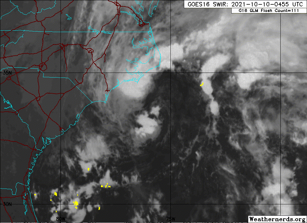
If it can blow up more central Convection then it will need to be upgraded. This is better organized then a few tropical and subtropical storms this season.
0 likes
-
cycloneye

- Admin

- Posts: 149550
- Age: 69
- Joined: Thu Oct 10, 2002 10:54 am
- Location: San Juan, Puerto Rico
Re: ATL: INVEST 92L - Discussion
Looks like no Wanda from this.
Tropical Weather Outlook
NWS National Hurricane Center Miami FL
800 AM EDT Sun Oct 10 2021
For the North Atlantic...Caribbean Sea and the Gulf of Mexico:
Shower and thunderstorm activity has decreased and become less
organized in association with a large non-tropical low pressure area
located about 90 miles southeast of Morehead City, North Carolina.
Earlier satellite wind data indicated that the system was producing
an area of gale-force winds in its northern semicircle offshore the
North Carolina coast. However, dry air and strong upper-level winds
are beginning to decrease the chance for further development of this
system. The low is forecast to move slowly north-northeastward and
approach eastern North Carolina later today. Interests in that area
should monitor the progress of this system and refer to local
National Weather Service office products for more information.
Regardless of development, intermittent periods of locally heavy
rains and gusty winds will affect southeastern and eastern portions
of North Carolina during the next day or two. Additional
information on this low pressure system, including gale warnings,
can be found in High Seas Forecasts issued by the National Weather
Service.
* Formation chance through 48 hours...low...30 percent.
* Formation chance through 5 days...low...30 percent.
&&
High Seas Forecasts issued by the National Weather Service can be
found under AWIPS header NFDHSFAT1, WMO header FZNT01 KWBC, and
online at ocean.weather.gov/shtml/NFDHSFAT1.php
$$
Forecaster Latto
1 likes
Visit the Caribbean-Central America Weather Thread where you can find at first post web cams,radars
and observations from Caribbean basin members Click Here
and observations from Caribbean basin members Click Here
-
AlphaToOmega
- Category 5
- Posts: 1448
- Joined: Sat Jun 26, 2021 10:51 am
- Location: Somewhere in Massachusetts

Re: ATL: INVEST 92L - Discussion
AlphaToOmega wrote:How was this not classified?
Not enough persistent convection near the LLC. Maybe this’ll get a post-season upgrade like the 2005 Azores system.
1 likes
Irene '11 Sandy '12 Hermine '16 5/15/2018 Derecho Fay '20 Isaias '20 Elsa '21 Henri '21 Ida '21
I am only a meteorology enthusiast who knows a decent amount about tropical cyclones. Look to the professional mets, the NHC, or your local weather office for the best information.
I am only a meteorology enthusiast who knows a decent amount about tropical cyclones. Look to the professional mets, the NHC, or your local weather office for the best information.
-
wxman57

- Moderator-Pro Met

- Posts: 23175
- Age: 68
- Joined: Sat Jun 21, 2003 8:06 pm
- Location: Houston, TX (southwest)
Re: ATL: INVEST 92L - Discussion
AlphaToOmega wrote:How was this not classified?
Looks like it's a frontal low. Peaked last night and will be weakening going forward. I can't believe they're flying recon into it.
2 likes
Who is online
Users browsing this forum: No registered users and 26 guests