ATL: INVEST 93L - Discussion
Moderator: S2k Moderators


Re: ATL: INVEST 93L - Discussion
If 93L does develop, it’ll probably be around the very NE Caribbean islands or just to the NE of them, like what last week’s GFS runs originally showed for this system. It could take a track very similar to Sebastian ‘19.
0 likes
Irene '11 Sandy '12 Hermine '16 5/15/2018 Derecho Fay '20 Isaias '20 Elsa '21 Henri '21 Ida '21
I am only a meteorology enthusiast who knows a decent amount about tropical cyclones. Look to the professional mets, the NHC, or your local weather office for the best information.
I am only a meteorology enthusiast who knows a decent amount about tropical cyclones. Look to the professional mets, the NHC, or your local weather office for the best information.

-
Sciencerocks
- Category 5

- Posts: 10186
- Age: 40
- Joined: Thu Jul 06, 2017 1:51 am

Re: ATL: INVEST 93L - Discussion
 Can 93L surprise us?
There were droughts in the 1780s in the Caribbean. It looks like La Nina with negative Pacific Decadal Oscillation (PDO).
Multiyear La Niña events and persistent drought in the contiguous United States
https://agupubs.onlinelibrary.wiley.com ... 01GL013561
Multi-decadal climate variability: Flood and Drought - New South Wales
http://www.lavoisier.com.au/articles/gr ... ks2007.pdf
El Niño in Australia
http://www-das.uwyo.edu/~geerts/cwx/not ... _enso.html
The 1780s: Global Climate Anomalies, Floods, Droughts, and Famines
http://sro.sussex.ac.uk/id/eprint/83046 ... vised1.pdf
Interannual to Decadal Drought and Wildfire in the Western United States
https://www.firescience.gov/projects/01 ... ble_02.pdf
2 likes
-
Weatherwatcher2018
- Tropical Depression

- Posts: 82
- Joined: Wed Sep 26, 2018 4:30 pm

Re: ATL: INVEST 93L - Discussion
93L looks to be building nicely this morning theres 2 convection towers, however there is some shear.
GOES16 CIRA Proxy Visible product Source- https://col.st/gvntm
GOES16 CIRA Proxy Visible product Source- https://col.st/gvntm
2 likes
-
Stormybajan

- Category 1

- Posts: 453
- Joined: Thu May 20, 2021 3:21 pm
- Location: Windward Islands
Re: ATL: INVEST 93L - Discussion
Weatherwatcher2018 wrote:What’s the synopsis this morning
Well, development chances in the 5 day period has been reduced from 30 to 20 %, so maybe quick TD development has been thrown through the window now? However nhc still do say the lesser antilles could receive heavy rain and gusty winds from 93L so I guess not much has changed in that aspect. Should see some rain tonight and tomorrow
2 likes
Sad West Indies and Manchester United fan ⚽️

Re: ATL: INVEST 93L - Discussion
Weatherwatcher2018 wrote:What’s the synopsis this morning
Relevant paragraph from the 8 AM Tropical Weather Outlook:
A tropical wave located about 350 miles east-southeast of the
Windward Islands is producing an area of showers and a few
thunderstorms. Some slow development is possible during the next day
or two while the system moves west-northwestward at about 15 mph
toward the Lesser Antilles. Strong upper-level winds are expected to
limit further development on Tuesday. Regardless of development,
the system could produce locally heavy rainfall and gusty winds
across portions of the central and northern Lesser Antilles on
Tuesday, and across the Virgin Islands and Leeward Islands on
Wednesday.
* Formation chance through 48 hours...low...20 percent.
* Formation chance through 5 days...low...20 percent.
2 likes
-
InfernoFlameCat

- Category 5
- Posts: 2127
- Age: 22
- Joined: Mon Dec 14, 2020 10:52 am
- Location: Buford, GA
Re: ATL: INVEST 93L - Discussion
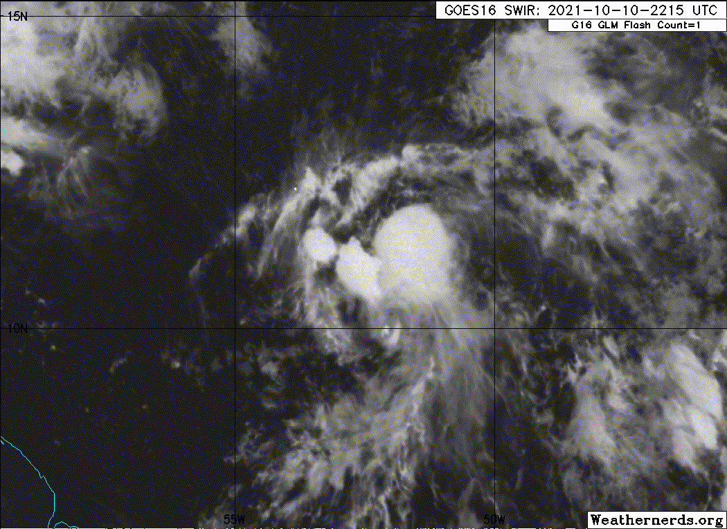
An llc is now visible, At least a developing one is. Also a big blowup of more organized convection to the west of the partial llc has likely aided the llc in developing.
1 likes
I am by no means a professional. DO NOT look at my forecasts for official information or make decisions based on what I post.
Goal: to become a registered expert over tropical and subtropical cyclones.
Goal: to become a registered expert over tropical and subtropical cyclones.

Re: ATL: INVEST 93L - Discussion
InfernoFlameCat wrote:An llc is now visible, At least a developing one is. Also a big blowup of more organized convection to the west of the partial llc has likely aided the llc in developing.
Yeah, if this can sustain itself, it would at least look better than Kate, Peter and Rose did at their worst, regardless of whether 93L gets named or not.
3 likes
TC naming lists: retirements and intensity
Most aggressive Advisory #1's in North Atlantic (cr. kevin for starting the list)
Most aggressive Advisory #1's in North Atlantic (cr. kevin for starting the list)
Re: ATL: INVEST 93L - Discussion
Teban54 wrote:InfernoFlameCat wrote:An llc is now visible, At least a developing one is. Also a big blowup of more organized convection to the west of the partial llc has likely aided the llc in developing.
Yeah, if this can sustain itself, it would at least look better than Kate, Peter and Rose did at their worst, regardless of whether 93L gets named or not.

2 likes
Re: ATL: INVEST 93L - Discussion
abajan wrote:Teban54 wrote:InfernoFlameCat wrote:An llc is now visible, At least a developing one is. Also a big blowup of more organized convection to the west of the partial llc has likely aided the llc in developing.
Yeah, if this can sustain itself, it would at least look better than Kate, Peter and Rose did at their worst, regardless of whether 93L gets named or not.
https://i.imgur.com/BwuxSlV.gif
If you look carefully, you can see the LLC just to the west of the huge convective blowup.
Either the explosion in convection blows away the LLC completely (IIRC Josephine, Rene and one of the weak storms this year dissipated this way), or the LLC survives and we have something classifiable, albeit heavily sheared. We'll see.
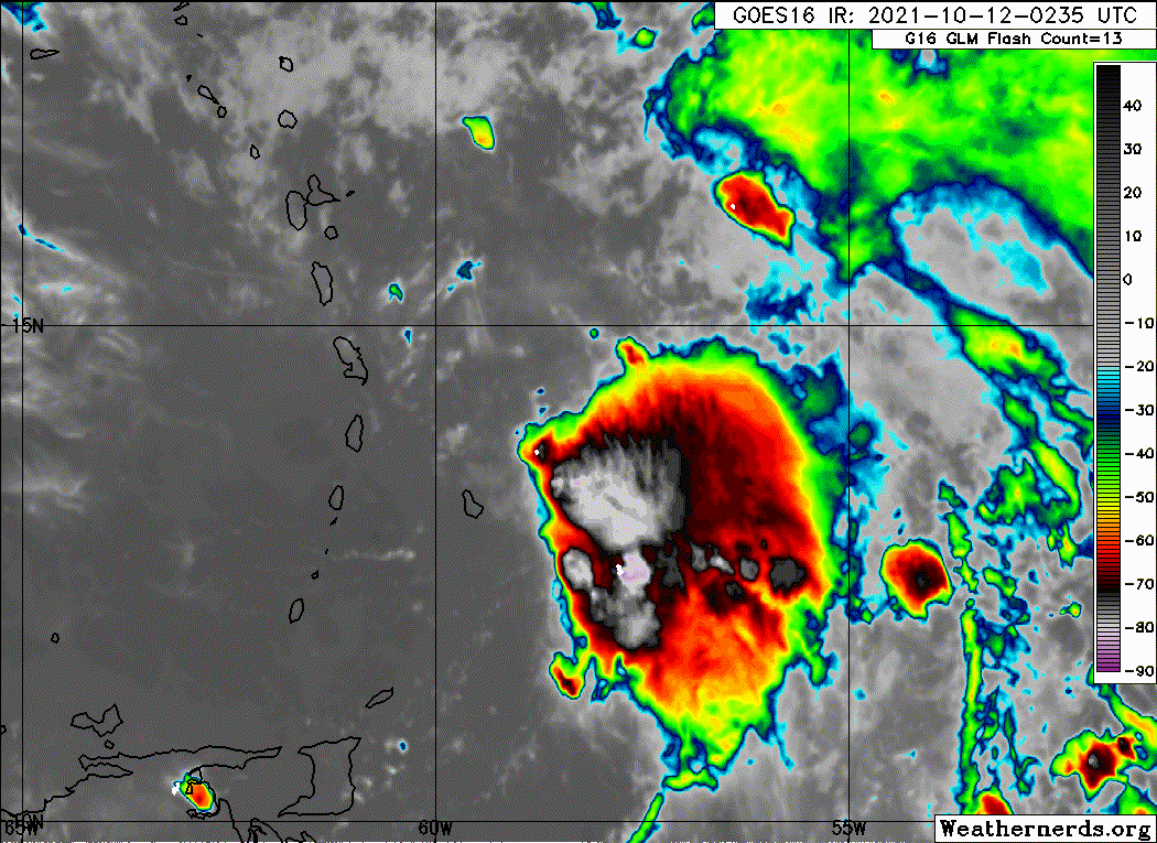
Edit: Shortwave IR tells the story better:

3 likes
TC naming lists: retirements and intensity
Most aggressive Advisory #1's in North Atlantic (cr. kevin for starting the list)
Most aggressive Advisory #1's in North Atlantic (cr. kevin for starting the list)
-
Stormybajan
- Category 1
- Posts: 453
- Joined: Thu May 20, 2021 3:21 pm
- Location: Windward Islands
Re: ATL: INVEST 93L - Discussion
Teban54 wrote:abajan wrote:Teban54 wrote:Yeah, if this can sustain itself, it would at least look better than Kate, Peter and Rose did at their worst, regardless of whether 93L gets named or not.
https://i.imgur.com/BwuxSlV.gif
If you look carefully, you can see the LLC just to the west of the huge convective blowup.
Either the explosion in convection blows away the LLC completely (IIRC Josephine, Rene and one of the weak storms this year dissipated this way), or the LLC survives and we have something classifiable, albeit heavily sheared. We'll see.
Edit: Shortwave IR tells the story better:
https://i.ibb.co/0K8w6WV/goes16-vis-swir-93-L-202110111845.gif
Any chance the LLC gets sucked up southwest into the convection or is the shear too strong or is it speeding along too quickly?
0 likes
Sad West Indies and Manchester United fan ⚽️

Re: ATL: INVEST 93L - Discussion
Looks like this Invest is consolidating closer to Barbados with a big blow up of convection.
Appears like the sheer has lessened in the last few hours.
Appears like the sheer has lessened in the last few hours.
1 likes
-
Sciencerocks
- Category 5
- Posts: 10186
- Age: 40
- Joined: Thu Jul 06, 2017 1:51 am
Re: ATL: INVEST 93L - Discussion
colbroe wrote:Looks like this Invest is consolidating closer to Barbados with a big blow up of convection.
Appears like the sheer has lessened in the last few hours.
It's epic how quickly the associated convection dissipated. Last night, before heading to bed, I could've sworn we would get lots of heavy showers with thunder. And, as I discovered minutes ago, about six hours ago our met office even issued a flash flood warning and severe thunderstorm warning.

5 likes
-
hurricanes1234
- Category 5
- Posts: 2908
- Joined: Sat Jul 28, 2012 6:19 pm
- Location: Trinidad and Tobago
Re: ATL: INVEST 93L - Discussion
Same here in T&T, we were supposed to get peripheral rainfall from this overnight last night into this morning and it's been bone dry. Yesterday was forecast to be fairly wet as well during the day and the only thing present was Saharan dust. Just dry air and strong shear everywhere you look. On the satellite loop, you could see all the cloud tops being blown off to the east and southeast by these relentless upper-level winds.
Looks more like November in an ENSO-neutral year than October in a La Niña year.
Looks more like November in an ENSO-neutral year than October in a La Niña year.
1 likes
PLEASE NOTE: With the exception of information from weather agencies that I may copy and paste here, my posts will NEVER be official, since I am NOT a meteorologist. They are solely my amateur opinion, and may or may not be accurate. Therefore, please DO NOT use them as official details, particularly when making important decisions. Thank you.
Re: ATL: INVEST 93L - Discussion
93L got too excited about the upcoming CCKW and tried to develop too early, it seems. Or it exploded like Josephine. Hard to tell from shortwave IR loops.
1 likes
Irene '11 Sandy '12 Hermine '16 5/15/2018 Derecho Fay '20 Isaias '20 Elsa '21 Henri '21 Ida '21
I am only a meteorology enthusiast who knows a decent amount about tropical cyclones. Look to the professional mets, the NHC, or your local weather office for the best information.
I am only a meteorology enthusiast who knows a decent amount about tropical cyclones. Look to the professional mets, the NHC, or your local weather office for the best information.
Re: ATL: INVEST 93L - Discussion
From this loop, it seems the LLC is currently about 100 miles ENE of Barbados:

0 likes
Who is online
Users browsing this forum: No registered users and 30 guests