https://twitter.com/philklotzbach/status/1432729905913946116
ENSO Updates (2007 thru 2023)
Moderator: S2k Moderators
Forum rules

The posts in this forum are NOT official forecasts and should not be used as such. They are just the opinion of the poster and may or may not be backed by sound meteorological data. They are NOT endorsed by any professional institution or STORM2K. For official information, please refer to products from the National Hurricane Center and National Weather Service.
-
Yellow Evan

- Professional-Met

- Posts: 16237
- Age: 27
- Joined: Fri Jul 15, 2011 12:48 pm
- Location: Henderson, Nevada/Honolulu, HI
- Contact:
-
Category5Kaiju

- Category 5

- Posts: 4332
- Joined: Thu Dec 24, 2020 12:45 pm
- Location: Seattle and Phoenix
Re: ENSO Updates
Kingarabian wrote:mrbagyo wrote:https://i.imgur.com/mvYMmEn.png
cold anomaly has now reached the dateline
how long will this Niña last
From what I'm seeing, pretty good shot there will be another La Nina for 2022. We'll know easily by February though.
Simply imagining the prospect of a triple year La Niña and potentially a seventh consecutive above average Atlantic is just crazy, but hey, I’m willing to believe that it has a chance of occurring due to how strong the WAM has been in recent years and how the tropical Atlantic has just been behaving haywire in recent seasons.
5 likes
Unless explicitly stated, all info in my posts is based on my own opinions and observations. Tropical storms and hurricanes can be extremely dangerous. Refer to an accredited weather research agency or meteorologist if you need to make serious decisions regarding an approaching storm.
-
Yellow Evan
- Professional-Met
- Posts: 16237
- Age: 27
- Joined: Fri Jul 15, 2011 12:48 pm
- Location: Henderson, Nevada/Honolulu, HI
- Contact:
-
Kingarabian

- S2K Supporter

- Posts: 16358
- Joined: Sat Aug 08, 2009 3:06 am
- Location: Honolulu, Hawaii
-
Yellow Evan
- Professional-Met
- Posts: 16237
- Age: 27
- Joined: Fri Jul 15, 2011 12:48 pm
- Location: Henderson, Nevada/Honolulu, HI
- Contact:
-
cycloneye

- Admin

- Posts: 149422
- Age: 69
- Joined: Thu Oct 10, 2002 10:54 am
- Location: San Juan, Puerto Rico
Re: ENSO Updates
EL NIÑO/SOUTHERN OSCILLATION (ENSO)
DIAGNOSTIC DISCUSSION
issued by
CLIMATE PREDICTION CENTER/NCEP/NWS
and the International Research Institute for Climate and Society
9 September 2021
ENSO Alert System Status: La Niña Watch
Synopsis: A transition from ENSO-neutral to La Niña is favored in the next couple of months, with a 70-80% chance of La Niña during the Northern Hemisphere winter 2021-22.
In the last month, ENSO-neutral continued with near-to-below average sea surface temperatures (SSTs) persisting in the central and eastern equatorial Pacific [Fig. 1]. In the last week, all of the Niño index values ranged from -0.2°C to -0.3°C [Fig. 2]. Negative subsurface temperature anomalies (averaged from 180-100°W) remained steady in August [Fig. 3], reflecting below-average temperatures that extended from the surface to ~250m depth in the eastern Pacific Ocean [Fig. 4]. Low-level wind anomalies were easterly over the western Pacific Ocean, while upper-level wind anomalies were westerly over the western and east-central Pacific. Tropical convection was suppressed near and west of the Date Line and enhanced over Indonesia [Fig. 5]. Given these conditions, the ocean-atmosphere system reflected ENSO-neutral, but is edging toward La Niña.
The IRI/CPC plume average of forecasts for the Niño-3.4 SST region from the last month favored borderline or weak La Niña during the fall and winter 2021-22 [Fig. 6]. The forecaster consensus this month, however, favors the latest predictions from the NCEP CFSv2 and the North American Multi-Model Ensemble, which suggest higher chances for the emergence of La Niña. At this time, forecasters anticipate La Niña to be of weak strength (seasonal average Niño-3.4 index values between -0.5°C to -0.9°C). In summary, a transition from ENSO-neutral to La Niña is favored in the next couple of months, with a 70-80% chance of La Niña during the Northern Hemisphere winter 2021-22 (click CPC/IRI consensus forecast for the chances in each 3-month period).

https://www.cpc.ncep.noaa.gov/products/ ... disc.shtml
0 likes
Visit the Caribbean-Central America Weather Thread where you can find at first post web cams,radars
and observations from Caribbean basin members Click Here
and observations from Caribbean basin members Click Here
-
Category5Kaiju
- Category 5
- Posts: 4332
- Joined: Thu Dec 24, 2020 12:45 pm
- Location: Seattle and Phoenix
Re: ENSO Updates
Wow.

If this were to actually pan out, then I would have to imagine that this would have at least some implications on the 2022 Atlantic hurricane season, no? Because wouldn't an El Nino the year after this strong of a La Nina occurs be hard to achieve?
0 likes
Unless explicitly stated, all info in my posts is based on my own opinions and observations. Tropical storms and hurricanes can be extremely dangerous. Refer to an accredited weather research agency or meteorologist if you need to make serious decisions regarding an approaching storm.
-
Kingarabian
- S2K Supporter
- Posts: 16358
- Joined: Sat Aug 08, 2009 3:06 am
- Location: Honolulu, Hawaii
Re: ENSO Updates
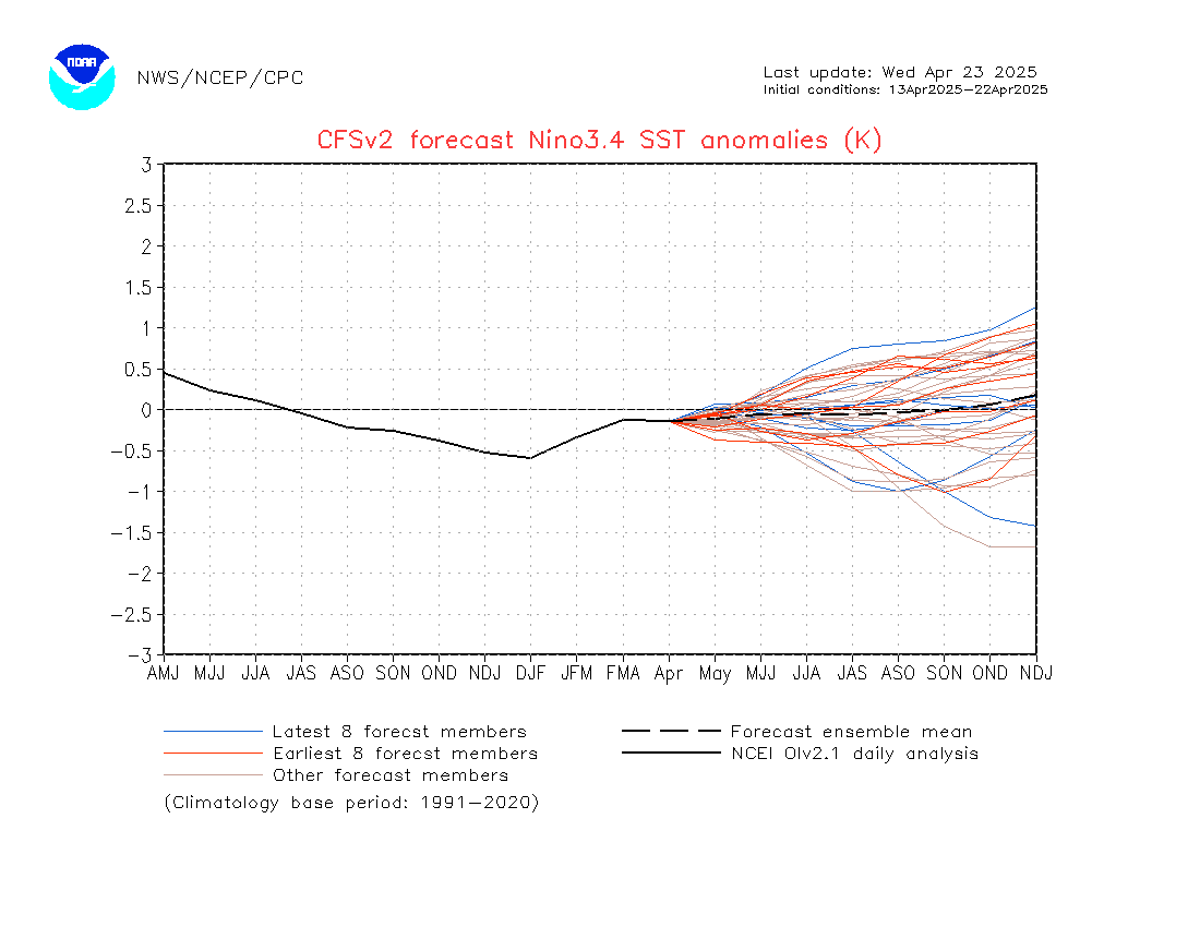
Category5Kaiju wrote:https://www.cpc.ncep.noaa.gov/products/CFSv2/imagesInd3/nino34Sea.gif
Wow.
If this were to actually pan out, then I would have to imagine that this would have at least some implications on the 2022 Atlantic hurricane season, no? Because wouldn't an El Nino the year after this strong of a La Nina occurs be hard to achieve?
It's 50/50 for an El Nino or La Nina for 2022. We won't have a clear picture until about late winter. An earlier peak of La Nina could open the door for a +ENSO event, while a later peak could reduce the amount of time for +ENSO to come on and would favor a La Nina return by July 2022.
0 likes
RIP Kobe Bryant
-
Yellow Evan
- Professional-Met
- Posts: 16237
- Age: 27
- Joined: Fri Jul 15, 2011 12:48 pm
- Location: Henderson, Nevada/Honolulu, HI
- Contact:
Re: ENSO Updates
Keep in mind the CFS showed the same thing at this time last year and in 2010. Neither panned out to expectation.
0 likes
-
Kingarabian
- S2K Supporter
- Posts: 16358
- Joined: Sat Aug 08, 2009 3:06 am
- Location: Honolulu, Hawaii
Re: ENSO Updates
First clue for 2022 ENSO is the PMM and PDO which start to give us a hint on where their leaning during the early and late winter months. So far it looks like it's trending positive. However, the PDO looks to remain negative for the remainder of 2021.
0 likes
RIP Kobe Bryant
-
Yellow Evan
- Professional-Met
- Posts: 16237
- Age: 27
- Joined: Fri Jul 15, 2011 12:48 pm
- Location: Henderson, Nevada/Honolulu, HI
- Contact:
-
AlphaToOmega
- Category 5
- Posts: 1448
- Joined: Sat Jun 26, 2021 10:51 am
- Location: Somewhere in Massachusetts
-
Yellow Evan
- Professional-Met
- Posts: 16237
- Age: 27
- Joined: Fri Jul 15, 2011 12:48 pm
- Location: Henderson, Nevada/Honolulu, HI
- Contact:
Re: ENSO Updates
0 likes
-
Category5Kaiju
- Category 5
- Posts: 4332
- Joined: Thu Dec 24, 2020 12:45 pm
- Location: Seattle and Phoenix
Re: ENSO Updates
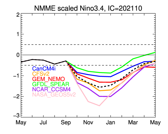
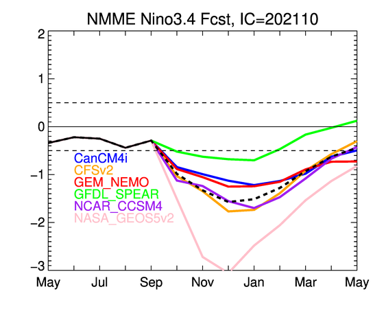
https://twitter.com/BenNollWeather/status/1446462129310101511
Wow. I seriously wonder what the implications would be for the 2022 Atlantic hurricane season if a late and long-peaking moderate La Nina were to pan out.
Wow. I seriously wonder what the implications would be for the 2022 Atlantic hurricane season if a late and long-peaking moderate La Nina were to pan out.
0 likes
Unless explicitly stated, all info in my posts is based on my own opinions and observations. Tropical storms and hurricanes can be extremely dangerous. Refer to an accredited weather research agency or meteorologist if you need to make serious decisions regarding an approaching storm.
-
Kingarabian
- S2K Supporter
- Posts: 16358
- Joined: Sat Aug 08, 2009 3:06 am
- Location: Honolulu, Hawaii
Re: ENSO Updates
Category5Kaiju wrote:https://twitter.com/BenNollWeather/status/1446462129310101511
Wow. I seriously wonder what the implications would be for the 2022 Atlantic hurricane season if a late and long-peaking moderate La Nina were to pan out.
This La Nina should peak around -1.0C. But -1.5C is overcooked. Why is the NASA model still used in the NMME? Should've been discontinued or fixed by now.
0 likes
RIP Kobe Bryant
-
Kingarabian
- S2K Supporter
- Posts: 16358
- Joined: Sat Aug 08, 2009 3:06 am
- Location: Honolulu, Hawaii
Re: ENSO Updates
PMM shifted shifted positive for September. PDO remains very cold.
0 likes
RIP Kobe Bryant

Re: ENSO Updates
Seeing how prevalent mid-level shear is in the EPac and how previously unforeseen ENSO-enhanced environmental factors have kept Pamela from intensifying much despite going over sub-875mb MPIs…yeah, I think the atmosphere has responded to the La Niña lol.
2 likes
Irene '11 Sandy '12 Hermine '16 5/15/2018 Derecho Fay '20 Isaias '20 Elsa '21 Henri '21 Ida '21
I am only a meteorology enthusiast who knows a decent amount about tropical cyclones. Look to the professional mets, the NHC, or your local weather office for the best information.
I am only a meteorology enthusiast who knows a decent amount about tropical cyclones. Look to the professional mets, the NHC, or your local weather office for the best information.

Re: ENSO Updates
aspen wrote:Seeing how prevalent mid-level shear is in the EPac and how previously unforeseen ENSO-enhanced environmental factors have kept Pamela from intensifying much despite going over sub-875mb MPIs…yeah, I think the atmosphere has responded to the La Niña lol.
So now the billion dollar question is when the atmosphere in the Atlantic will respond, if it hasn't already.
It's also hard to determine if the current less-than ideal conditions (that prevented systems like 93L from being a much bigger threat) are solely due to unfavorable intraseasonal variations, or if there was actually some traces of warm neutral-like upper level conditions earlier in the season that made it so CCKW-dependent.
0 likes
TC naming lists: retirements and intensity
Most aggressive Advisory #1's in North Atlantic (cr. kevin for starting the list)
Most aggressive Advisory #1's in North Atlantic (cr. kevin for starting the list)


Re: ENSO Updates
The BoM has declared a La Niña alert, meaning the chances of a sub -0.8 °C La Niña forming are ca. 70%.
http://www.bom.gov.au/climate/enso/index.shtml

http://www.bom.gov.au/climate/enso/index.shtml
1 likes
-
cycloneye
- Admin
- Posts: 149422
- Age: 69
- Joined: Thu Oct 10, 2002 10:54 am
- Location: San Juan, Puerto Rico
Re: ENSO: CPC: Official - La Niña is here
Is now a done deal about La NIña dominating the atmosphere in the Pacific.
https://www.cpc.ncep.noaa.gov/products/ ... disc.shtml

EL NIÑO/SOUTHERN OSCILLATION (ENSO)
DIAGNOSTIC DISCUSSION
issued by
CLIMATE PREDICTION CENTER/NCEP/NWS
and the International Research Institute for Climate and Society
14 October 2021
ENSO Alert System Status: La Niña Advisory
Synopsis: La Niña conditions have developed and are expected to continue with an 87% chance of La Niña in December 2021- February 2022.
In the past month, La Niña conditions emerged, as indicated by below-average sea surface temperatures (SSTs) across the central and east-central equatorial Pacific [Fig. 1]. In the last week, the Niño-3.4 and Niño-4 index values were -0.6°C and -0.7°C, respectively [Fig. 2]. The Niño-3 and Niño-1+2 indices were not as cool, with values at -0.3°C and 0.1°C. Below-average subsurface temperatures (averaged from 180-100°W) strengthened significantly in the past month [Fig. 3], as negative anomalies were observed at depth across most of the central and eastern Pacific Ocean [Fig. 4]. Low-level easterly wind anomalies and upper-level westerly wind anomalies were observed over most of the equatorial Pacific. Tropical convection was suppressed near and west of the Date Line and enhanced over Indonesia [Fig. 5], while the Southern Oscillation Index and Equatorial Southern Oscillation Index were both positive. Overall, the coupled ocean-atmosphere system was consistent with La Niña conditions.
The IRI/CPC plume average of forecasts for the Niño-3.4 SST index favors La Niña to continue through the fall and winter 2021-22 [Fig. 6]. The forecaster consensus also anticipates La Niña to continue through the winter, with ENSO-neutral predicted to return during March-May 2022. Because of the recent oceanic cooling and coupling to the atmosphere, forecasters now anticipate a 57% chance of one season (November-January) reaching -1.0°C or less in the Niño-3.4 index. Thus, at its peak, a moderate-strength La Niña is favored. In summary, La Niña conditions have developed and are expected to continue with an 87% chance of La Niña in December 2021- February 2022 (click CPC/IRI consensus forecast for the chances in each 3-month period).
La Niña is anticipated to affect temperature and precipitation across the United States during the upcoming months (the 3-month seasonal temperature and precipitation outlooks will be updated on Thurs. October 21st).
https://www.cpc.ncep.noaa.gov/products/ ... disc.shtml
0 likes
Visit the Caribbean-Central America Weather Thread where you can find at first post web cams,radars
and observations from Caribbean basin members Click Here
and observations from Caribbean basin members Click Here
Who is online
Users browsing this forum: No registered users and 43 guests