EPAC: PAMELA - Remnants
Moderator: S2k Moderators

Re: EPAC: PAMELA - Hurricane
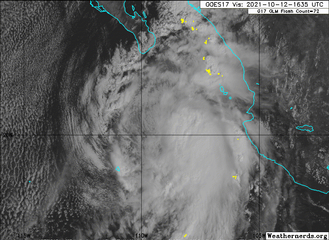
Clearly, mid-level shear is something the models still struggle with and need improvement on. This is the worst mid level shear-related bust I can recall. Delta doesn’t count, because it was already a Cat 5 undergoing ERI before the unexpected shear hit, and it was able to recover later on. The mid level shear Pamela is struggling with has been far more persistent.
1 likes
Irene '11 Sandy '12 Hermine '16 5/15/2018 Derecho Fay '20 Isaias '20 Elsa '21 Henri '21 Ida '21
I am only a meteorology enthusiast who knows a decent amount about tropical cyclones. Look to the professional mets, the NHC, or your local weather office for the best information.
I am only a meteorology enthusiast who knows a decent amount about tropical cyclones. Look to the professional mets, the NHC, or your local weather office for the best information.

Re: EPAC: PAMELA - Hurricane
Welp, FL winds in the NE quad are not even close to hurricane-force FL, much less hurricane-force surface winds. Shouldn't be surprising that the SE quad is the strongest given Pamela's current structure.
0 likes
TC naming lists: retirements and intensity
Most aggressive Advisory #1's in North Atlantic (cr. kevin for starting the list)
Most aggressive Advisory #1's in North Atlantic (cr. kevin for starting the list)
-
cycloneye

- Admin

- Posts: 149508
- Age: 69
- Joined: Thu Oct 10, 2002 10:54 am
- Location: San Juan, Puerto Rico
Re: EPAC: PAMELA - Hurricane
Down to 60 kts.
EP, 16, 2021101218, , BEST, 0, 206N, 1093W, 60, 989, TS
1 likes
Visit the Caribbean-Central America Weather Thread where you can find at first post web cams,radars
and observations from Caribbean basin members Click Here
and observations from Caribbean basin members Click Here
Re: EPAC: PAMELA - Tropical Storm
aspen wrote:
If Pamela does bomb out into a pinhole Cat 5 like Patricia, hopefully it’s at the perfect time for recon and increasing shear weakens Pamela before landfall.
So much for the perfectly timed recon
0 likes
TC naming lists: retirements and intensity
Most aggressive Advisory #1's in North Atlantic (cr. kevin for starting the list)
Most aggressive Advisory #1's in North Atlantic (cr. kevin for starting the list)
Re: EPAC: PAMELA - Tropical Storm
Teban54 wrote:aspen wrote:
If Pamela does bomb out into a pinhole Cat 5 like Patricia, hopefully it’s at the perfect time for recon and increasing shear weakens Pamela before landfall.
So much for the perfectly timed recon
At least there wasn’t a crazy peak that recon would miss lol
0 likes
Irene '11 Sandy '12 Hermine '16 5/15/2018 Derecho Fay '20 Isaias '20 Elsa '21 Henri '21 Ida '21
I am only a meteorology enthusiast who knows a decent amount about tropical cyclones. Look to the professional mets, the NHC, or your local weather office for the best information.
I am only a meteorology enthusiast who knows a decent amount about tropical cyclones. Look to the professional mets, the NHC, or your local weather office for the best information.
-
Yellow Evan

- Professional-Met

- Posts: 16240
- Age: 27
- Joined: Fri Jul 15, 2011 12:48 pm
- Location: Henderson, Nevada/Honolulu, HI
- Contact:
-
Yellow Evan
- Professional-Met
- Posts: 16240
- Age: 27
- Joined: Fri Jul 15, 2011 12:48 pm
- Location: Henderson, Nevada/Honolulu, HI
- Contact:
-
SconnieCane
- Category 5

- Posts: 1013
- Joined: Thu Aug 02, 2018 5:29 pm
- Location: Madison, WI
Re: EPAC: PAMELA - Hurricane
aspen wrote:Clearly, mid-level shear is something the models still struggle with and need improvement on. This is the worst mid level shear-related bust I can recall. Delta doesn’t count, because it was already a Cat 5 undergoing ERI before the unexpected shear hit, and it was able to recover later on. The mid level shear Pamela is struggling with has been far more persistent.
Delta never made it to Cat. 5. 125kt operational peak, revised down to 120kt in TCR.
1 likes
Re: EPAC: PAMELA - Hurricane
SconnieCane wrote:aspen wrote:Clearly, mid-level shear is something the models still struggle with and need improvement on. This is the worst mid level shear-related bust I can recall. Delta doesn’t count, because it was already a Cat 5 undergoing ERI before the unexpected shear hit, and it was able to recover later on. The mid level shear Pamela is struggling with has been far more persistent.
Delta never made it to Cat. 5. 125kt operational peak, revised down to 120kt in TCR.
Typo, sorry. But the point still stands because Delta was already a major that exceeded expectations before the mid-level shear came.
0 likes
Irene '11 Sandy '12 Hermine '16 5/15/2018 Derecho Fay '20 Isaias '20 Elsa '21 Henri '21 Ida '21
I am only a meteorology enthusiast who knows a decent amount about tropical cyclones. Look to the professional mets, the NHC, or your local weather office for the best information.
I am only a meteorology enthusiast who knows a decent amount about tropical cyclones. Look to the professional mets, the NHC, or your local weather office for the best information.

Re: EPAC: PAMELA - Hurricane
Yellow Evan wrote:zzh wrote:SUMMARY OF 1200 PM MDT...1800 UTC...INFORMATION
-----------------------------------------------
LOCATION...20.5N 109.4W
ABOUT 265 MI...430 KM SW OF MAZATLAN MEXICO
ABOUT 175 MI...280 KM SSE OF THE SOUTHERN TIP OF BAJA CALIFORNIA
MAXIMUM SUSTAINED WINDS...80 MPH...130 KM/H
PRESENT MOVEMENT...N OR 355 DEGREES AT 8 MPH...13 KM/H
MINIMUM CENTRAL PRESSURE...991 MB...29.26 INCHES
The NHC keeps it at 70kt while recon only supports 50-55kt
Do you think dropping to 55 and then potentially going up to 65 is good messaging for a storm near land?
No but keeping it at 70kts when its clearly not at all close to that sort of level is a poor call clearly.
The GFS has so far severely busted on this one. With that being said its not impossible for it to still undergo rapid strengthening into landfall if the shear does ease up at any point.
Last edited by KWT on Tue Oct 12, 2021 2:42 pm, edited 1 time in total.
0 likes
Personal Forecast Disclaimer:
The posts in this forum are NOT official forecast and should not be used as such. They are just the opinion of the poster and may or may not be backed by sound meteorological data. They are NOT endorsed by any professional institution or storm2k.org. For official information, please refer to the NHC and NWS products
The posts in this forum are NOT official forecast and should not be used as such. They are just the opinion of the poster and may or may not be backed by sound meteorological data. They are NOT endorsed by any professional institution or storm2k.org. For official information, please refer to the NHC and NWS products
-
Kingarabian

- S2K Supporter

- Posts: 16366
- Joined: Sat Aug 08, 2009 3:06 am
- Location: Honolulu, Hawaii
Re: EPAC: PAMELA - Hurricane
Pamela is the cherry on top of the models struggles this year for this general area box. They never were able to diagnose the shear in this area correctly.
6 likes
RIP Kobe Bryant

Re: EPAC: INVEST 91E
From four days ago:
Looks like the Euro was right about one thing
Ubuntwo wrote:the Euro never develops a proper anticyclone over 91E leading to a sheared, struggling system (maybe a function of developing a different lobe of the monsoon trough?) Hmm... guess we'll see in a couple days.
Looks like the Euro was right about one thing
4 likes
Kendall -> SLO -> PBC
Memorable Storms: Katrina (for its Florida landfall...) Wilma Matthew Irma
Memorable Storms: Katrina (for its Florida landfall...) Wilma Matthew Irma
-
Sciencerocks
- Category 5
- Posts: 10186
- Age: 40
- Joined: Thu Jul 06, 2017 1:51 am
Re: EPAC: PAMELA - Tropical Storm
I’m sorry Stewart, but this isn’t gonna intensify much anymore. There’s literally no core with less than 24 hours before landfall. Dmax with the 31C SSTs could help Pamela out, but I doubt it’ll do much.
2 likes
Irene '11 Sandy '12 Hermine '16 5/15/2018 Derecho Fay '20 Isaias '20 Elsa '21 Henri '21 Ida '21
I am only a meteorology enthusiast who knows a decent amount about tropical cyclones. Look to the professional mets, the NHC, or your local weather office for the best information.
I am only a meteorology enthusiast who knows a decent amount about tropical cyclones. Look to the professional mets, the NHC, or your local weather office for the best information.
Re: EPAC: PAMELA - Tropical Storm
I feel like the tropics just wanted to troll Josh Morgerman. He refers to tropical storms as slop quite frequently and says they're not worth chasing, so the tropics decided to fake him out and get their revenge.
Since Pam is headed for land I'm glad she's been riding the struggle bus so far. Hopefully she continues and it's not a big impact.
I'm hoping the EPAC serves it up next year. I'm ready for big long trackers that rack up ACE and head out to sea.
Since Pam is headed for land I'm glad she's been riding the struggle bus so far. Hopefully she continues and it's not a big impact.
I'm hoping the EPAC serves it up next year. I'm ready for big long trackers that rack up ACE and head out to sea.
0 likes
Solar Aquarian
Lunar Cancerian
 Sagittarian
Lunar Cancerian
-
grapealcoholic
- Category 2

- Posts: 703
- Joined: Tue Aug 10, 2021 3:26 pm
Re: EPAC: PAMELA - Tropical Storm
aspen wrote:I’m sorry Stewart, but this isn’t gonna intensify much anymore. There’s literally no core with less than 24 hours before landfall. Dmax with the 31C SSTs could help Pamela out, but I doubt it’ll do much.
Eh, I disagree. 31C in October is basically in the upper 99th percentile of thermodynamic favorability (aside from like WPAC in November). Shear will fight it but thermodynamics should win out here -- just unsure how quickly it could deepen.
0 likes
-
ncforecaster89
- Category 1

- Posts: 269
- Age: 55
- Joined: Sat Oct 20, 2018 12:32 pm
- Contact:
Re: EPAC: PAMELA - Tropical Storm
I fully anticipate some decent intensification once it makes a further eastward turn towards a more direct NE heading. This will give Pamela the benefit of a much more favorable trough interaction whereby the shear should diminish a bit, as well increasing upper-level divergence. That, combined with anomalous SSTs, should allow Pamela to get to the 75-85 kt range.
0 likes
Re: EPAC: PAMELA - Tropical Storm
She's trying

Mexico dodged a massive bullet this time. Pamela will still be an unpleasant experience and a dangerous storm, but definitely far better than a 105-120kt major at landfall like the NHC was forecasting and the GFS, HWRF, and HMON showed.
Mexico dodged a massive bullet this time. Pamela will still be an unpleasant experience and a dangerous storm, but definitely far better than a 105-120kt major at landfall like the NHC was forecasting and the GFS, HWRF, and HMON showed.
1 likes
Irene '11 Sandy '12 Hermine '16 5/15/2018 Derecho Fay '20 Isaias '20 Elsa '21 Henri '21 Ida '21
I am only a meteorology enthusiast who knows a decent amount about tropical cyclones. Look to the professional mets, the NHC, or your local weather office for the best information.
I am only a meteorology enthusiast who knows a decent amount about tropical cyclones. Look to the professional mets, the NHC, or your local weather office for the best information.
-
Yellow Evan
- Professional-Met
- Posts: 16240
- Age: 27
- Joined: Fri Jul 15, 2011 12:48 pm
- Location: Henderson, Nevada/Honolulu, HI
- Contact:
Re: EPAC: INVEST 91E
Ubuntwo wrote:From four days ago:Ubuntwo wrote:the Euro never develops a proper anticyclone over 91E leading to a sheared, struggling system (maybe a function of developing a different lobe of the monsoon trough?) Hmm... guess we'll see in a couple days.
Looks like the Euro was right about one thing
The shear is coming from mid-levels though. A proper ULAC did become established so ECMWF wasn’t exactly right.
2 likes
-
cycloneye
- Admin
- Posts: 149508
- Age: 69
- Joined: Thu Oct 10, 2002 10:54 am
- Location: San Juan, Puerto Rico
Re: EPAC: PAMELA - Tropical Storm
EP, 16, 2021101300, , BEST, 0, 215N, 1089W, 60, 989, TS
0 likes
Visit the Caribbean-Central America Weather Thread where you can find at first post web cams,radars
and observations from Caribbean basin members Click Here
and observations from Caribbean basin members Click Here
Who is online
Users browsing this forum: No registered users and 31 guests