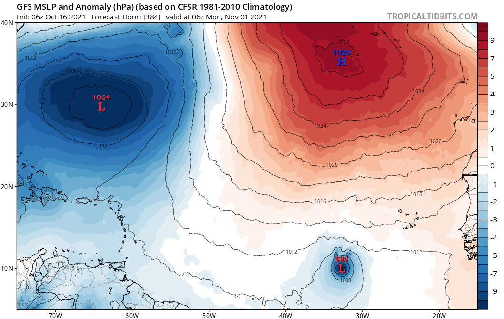
aspen wrote:What on Earth is that GFS run lol
An EPac crossover that spawns a hurricane in the Gulf, then a strong TS/weak hurricane in the eastern MDR in the last days of October. Apparently the GFS didn’t get the memo that both the Gulf and MDR are closed for business.
Right lol? Given Climo and especially given GFS's penchant for developing long range phantom storms, the idea of THAT verifying would seem just as ridiculous as some new Sharknado movie titled "Lurking Within The Eye of Wanda"

.
Let's entertain the idea for a moment (meaning the GFS long range, not the Sharknado movie). Why this year and this late in the season?? I largely subscribe to the "old school" thought of Climatology and Persistence, but will always defer to whatever the dynamic conditions present (regardless how anomalous they may appear). On the broader scale, it is interesting to view the last 2 1/2 months of the CDAS 3.4 Nino Index. For all the LaNina talk over most of the season, there has been little variance in the average SST bouncing right around -0.3 for a 45 day period from August 1st to about September 15. During the past 30 days since mid September, the CDAT 3.4 region clearly has graphed a consistent precipitous SST drop to -0.8 as of today. Notwithstanding whether the 3.4 Nino Index SST's level off or continue to drop, at minimum this would seem to suggest at least "some" subtle downstream pattern changes soon to occur. As to just how long of a time lag for these changes to impact the upper air environment, I'm not sure. One contributing factor may include the very warm SST pool in the far East Pac but that too could be mitigated by the even larger area of very warm SST's through much of the Caribbean and GOM.
One thing that's interesting is how the GFS 24 hr. short range model seems to immediately begin transforming the current strong unfavorable 200mb conditions over the W. Caribbean and Eastern/Northern GOM, to a full reversal that depicts a generally anticyclonic flow which in time appears to extend from the S. GOM to much of the Caribbean. This pattern change does seem to be the catalyst for what otherwise would be viewed as just another crazy GFS long range "ghost-storm". As for the date on the calendar, I might be quite skeptical if this were February, but not at all during Oct. or Nov. Providing that a legit rich tropical air mass were able to propagate north & modify conditions within the GOM or Caribbean along with the current SST's in place and a truly favorable upper air environment..... I'd have to assume that tropical development is a reasonable outcome. I personally doubt that development would originate from the far Western BOC but it's easy to imagine a similar solution with low pressure bubbling up from the south anywhere from the Eastern BOC to the Caribbean.
As for some record breaking far Eastern MDR development??? Sure, why not. Assuming ideal upper air conditions were in place, current very warm MDR SST's south of 14N, and the season-long display of strong tropical waves emanating from the African coastline during an already over-active hurricane season??? I wouldn't bet the farm on it but then again records are meant to be broken; Over enough time, they typically are.