https://rammb-data.cira.colostate.edu/tc_realtime/storm.asp?storm_identifier=ep922021
Synoptic Time Latitude Longitude Intensity
92E 2021-10-21 12:00 12.8 -95.5 25
EPAC: RICK - Remnants
Moderator: S2k Moderators
-
Nancy Smar

- Category 5

- Posts: 1081
- Age: 25
- Joined: Wed Aug 16, 2017 10:03 pm
EPAC: RICK - Remnants
0 likes
-
cycloneye

- Admin

- Posts: 149843
- Age: 69
- Joined: Thu Oct 10, 2002 10:54 am
- Location: San Juan, Puerto Rico
Re: EPAC: INVEST 92E
https://ftp.nhc.noaa.gov/atcf/btk/
EP, 92, 2021102112, , BEST, 0, 128N, 955W, 25, 1011, DB, 34, NEQ, 0, 0, 0, 0, 1012, 300, 50, 0, 0, E, 0, , 0, 0, INVEST, S, 0, , 0, 0, 0, 0, genesis-num, 029, SPAWNINVEST, ep722021 to ep922021,
0 likes
Visit the Caribbean-Central America Weather Thread where you can find at first post web cams,radars
and observations from Caribbean basin members Click Here
and observations from Caribbean basin members Click Here

Re: EPAC: INVEST 92E
HWRF gonna HWRF…the 12z run has a Cat 2/3 by Monday.
0 likes
Irene '11 Sandy '12 Hermine '16 5/15/2018 Derecho Fay '20 Isaias '20 Elsa '21 Henri '21 Ida '21
I am only a meteorology enthusiast who knows a decent amount about tropical cyclones. Look to the professional mets, the NHC, or your local weather office for the best information.
I am only a meteorology enthusiast who knows a decent amount about tropical cyclones. Look to the professional mets, the NHC, or your local weather office for the best information.
-
cycloneye
- Admin
- Posts: 149843
- Age: 69
- Joined: Thu Oct 10, 2002 10:54 am
- Location: San Juan, Puerto Rico
Re: EPAC: INVEST 92E
2 likes
Visit the Caribbean-Central America Weather Thread where you can find at first post web cams,radars
and observations from Caribbean basin members Click Here
and observations from Caribbean basin members Click Here
-
Yellow Evan

- Professional-Met

- Posts: 16257
- Age: 27
- Joined: Fri Jul 15, 2011 12:48 pm
- Location: Henderson, Nevada/Honolulu, HI
- Contact:
Re: EPAC: INVEST 92E
000
ABPZ20 KNHC 211732
TWOEP
Tropical Weather Outlook
NWS National Hurricane Center Miami FL
1100 AM PDT Thu Oct 21 2021
For the eastern North Pacific...east of 140 degrees west longitude:
Disorganized showers and thunderstorms within a few hundred miles of
the southern coast of Mexico are associated with a broad area of
low pressure located just to the southwest of the Gulf of
Tehuantepec. Environmental conditions are expected to be
conducive for gradual development of this system during the next
several days, and a tropical depression is likely to form by this
weekend while the system moves slowly west-northwestward to
northwestward near or just offshore the southern coast of Mexico.
* Formation chance through 48 hours...medium...50 percent.
* Formation chance through 5 days...high...90 percent.
$$
Forecaster Latto
0 likes
-
Yellow Evan
- Professional-Met
- Posts: 16257
- Age: 27
- Joined: Fri Jul 15, 2011 12:48 pm
- Location: Henderson, Nevada/Honolulu, HI
- Contact:

-
Yellow Evan
- Professional-Met
- Posts: 16257
- Age: 27
- Joined: Fri Jul 15, 2011 12:48 pm
- Location: Henderson, Nevada/Honolulu, HI
- Contact:
Re: EPAC: INVEST 92E
* GFS version *
* EAST PACIFIC 2021 SHIPS INTENSITY FORECAST *
* IR SAT DATA AVAILABLE, OHC AVAILABLE *
* INVEST EP922021 10/21/21 18 UTC *
TIME (HR) 0 6 12 18 24 36 48 60 72 84 96 108 120 132 144 156 168
V (KT) NO LAND 25 28 32 39 48 64 79 82 75 61 57 54 52 52 49 46 43
V (KT) LAND 25 28 32 39 48 64 79 82 75 43 32 28 30 30 27 24 21
V (KT) LGEM 25 26 27 30 33 43 54 61 61 39 30 28 30 31 31 31 31
Storm Type TROP TROP TROP TROP TROP TROP TROP TROP TROP TROP TROP TROP TROP TROP TROP TROP TROP
SHEAR (KT) 8 7 8 8 10 3 5 11 15 16 12 14 15 22 21 25 31
SHEAR ADJ (KT) -6 -5 -5 -5 -6 -4 -4 0 1 6 3 0 3 8 6 8 4
SHEAR DIR 101 100 89 71 68 87 93 134 162 183 233 233 262 267 263 257 261
SST (C) 29.5 29.5 29.4 29.5 29.6 29.9 30.4 30.6 30.1 28.5 27.9 28.3 28.7 29.2 29.0 28.9 29.2
POT. INT. (KT) 160 159 158 158 159 161 167 170 166 149 142 147 151 156 153 151 154
200 MB T (C) -53.6 -53.4 -53.8 -54.0 -53.6 -53.4 -52.9 -52.9 -52.3 -52.6 -52.5 -52.6 -52.7 -52.8 -52.9 -53.3 -53.5
200 MB VXT (C) 0.0 0.0 0.0 0.0 0.0 0.1 0.1 0.1 0.2 0.1 0.0 0.0 0.0 0.0 0.0 0.0 0.0
TH_E DEV (C) 6 5 5 4 6 5 7 7 9 8 8 7 10 10 12 12 13
700-500 MB RH 83 82 81 81 79 76 71 64 61 63 63 63 57 51 43 37 38
MODEL VTX (KT) 7 8 9 10 13 17 21 17 11 3 LOST LOST LOST LOST LOST LOST LOST
850 MB ENV VOR 30 29 30 35 36 50 52 57 57 51 14 5 -4 0 -19 -51 -34
200 MB DIV 103 135 152 136 129 180 214 173 129 51 50 23 22 6 5 5 5
700-850 TADV -1 -1 -1 0 -2 -2 -1 -3 -3 4 5 12 15 18 6 4 0
LAND (KM) 330 338 353 362 362 348 286 177 25 -196 -157 -53 82 244 395 365 288
LAT (DEG N) 12.8 12.9 12.9 13.0 13.2 13.6 14.3 15.2 16.4 18.2 19.8 21.4 23.1 xx.x xx.x xx.x xx.x
LONG(DEG W) 96.9 97.9 98.7 99.3 99.8 100.4 100.6 100.2 99.5 98.6 98.2 97.9 97.0 xxx.x xxx.x xxx.x xxx.x
STM SPEED (KT) 10 9 7 6 5 3 4 6 9 9 8 9 10 8 7 4 4
HEAT CONTENT 18 19 18 18 19 21 25 27 24 13 8 17 27 58 71 46 51
FORECAST TRACK FROM TABM INITIAL HEADING/SPEED (DEG/KT):270/ 10 CX,CY: -9/ 0
T-12 MAX WIND: 25 PRESSURE OF STEERING LEVEL (MB): 448 (MEAN=587)
GOES IR BRIGHTNESS TEMP. STD DEV. 50-200 KM RAD: 23.8 (MEAN=14.5)
% GOES IR PIXELS WITH T < -20 C 50-200 KM RAD: 61.0 (MEAN=65.0)
PRELIM RI PROB (DV .GE. 35 KT IN 36 HR): 47.2
INDIVIDUAL CONTRIBUTIONS TO INTENSITY CHANGE
6 12 18 24 36 48 60 72 84 96 108 120 132 144 156 168
------------------------------------------------------------------------------
SAMPLE MEAN CHANGE 0. 0. 1. 1. 1. 2. 1. 1. 0. -0. -1. -2. -2. -3. -4. -4.
SST POTENTIAL -0. -1. -1. 0. 5. 12. 19. 27. 31. 34. 36. 39. 42. 44. 46. 49.
VERTICAL SHEAR MAG 1. 2. 2. 3. 5. 5. 5. 5. 3. 2. 1. 1. -1. -3. -7. -11.
VERTICAL SHEAR ADJ 0. 1. 1. 2. 3. 4. 3. 2. 1. 0. 0. 0. 0. 0. -0. -0.
VERTICAL SHEAR DIR 0. 1. 2. 3. 5. 7. 7. 7. 6. 5. 4. 4. 4. 3. 3. 3.
PERSISTENCE -0. -0. -0. -1. -1. -1. -0. -0. -0. -0. -0. -0. -0. -0. -0. -0.
200/250 MB TEMP. 0. 0. 0. -0. -1. -1. -2. -3. -4. -4. -4. -3. -3. -3. -3. -3.
THETA_E EXCESS -0. -0. -1. -1. -1. -1. -1. -0. 0. 0. 1. 1. 2. 3. 4. 5.
700-500 MB RH 0. 0. 0. 1. 1. 1. 1. 1. 1. 1. 1. 1. 1. 1. 1. 1.
MODEL VTX TENDENCY 0. 1. 2. 5. 7. 13. 12. 4. -6. -6. -6. -5. -5. -4. -4. -4.
850 MB ENV VORTICITY 0. 0. 0. 0. 0. -0. -0. -0. -0. -0. -0. -0. -0. 0. 0. 0.
200 MB DIVERGENCE 0. 1. 1. 2. 3. 5. 8. 11. 11. 11. 9. 6. 4. 1. -0. -2.
850-700 T ADVEC 0. 0. -0. 0. 0. 0. -0. -0. -0. 0. 0. 0. 1. 1. 1. 2.
ZONAL STORM MOTION 0. 0. 0. 0. 1. 1. 1. 1. 1. 1. 1. 1. 0. 0. 0. -0.
STEERING LEVEL PRES -0. -0. -1. -1. -2. -2. -2. -2. -2. -3. -3. -3. -2. -2. -2. -1.
DAYS FROM CLIM. PEAK -0. -0. -0. -0. -0. -0. -1. -1. -1. -2. -2. -2. -3. -3. -4. -4.
GOES PREDICTORS 0. 0. 0. 0. -0. -1. -2. -2. -2. -3. -3. -3. -4. -3. -3. -3.
OCEAN HEAT CONTENT -0. -0. -0. -0. 0. 0. 0. 0. 0. 0. -0. -0. -0. -1. -3. -4.
RI POTENTIAL 1. 3. 6. 8. 13. 12. 6. 2. -1. -4. -6. -7. -7. -7. -7. -6.
------------------------------------------------------------------------------
TOTAL CHANGE 3. 7. 14. 23. 39. 54. 57. 50. 36. 32. 29. 27. 27. 24. 21. 18.
CURRENT MAX WIND (KT): 25. LAT, LON: 12.8 96.9
** 2021 E. Pacific RI INDEX EP922021 INVEST 10/21/21 18 UTC **
(SHIPS-RII PREDICTOR TABLE for 30 KT OR MORE MAXIMUM WIND INCREASE IN NEXT 24-h)
Predictor Value RI Predictor Range Scaled Value(0-1) % Contribution
POT = MPI-VMAX (KT) : 133.7 40.5 to 149.3 0.86 6.8
12 HR PERSISTENCE (KT) : 0.0 -22.0 to 44.0 0.33 3.0
D200 (10**7s-1) : 131.0 -33.0 to 159.5 0.85 6.3
850-200 MB SHEAR (KT) : 8.4 19.6 to 1.3 0.61 4.3
MAXIMUM WIND (KT) : 25.0 22.5 to 132.0 0.07 0.4
STD DEV OF IR BR TEMP : 23.8 37.8 to 2.1 0.39 2.0
BL DRY-AIR FLUX (W/M2) : 19.2 800.8 to -82.5 0.88 -4.9
HEAT CONTENT (KJ/CM2) : 18.4 2.7 to 106.7 0.15 0.6
%area of TPW <45 mm upshear : 0.0 56.6 to 0.0 1.00 1.6
2nd PC OF IR BR TEMP : -0.1 2.2 to -2.3 0.51 0.5
SHIPS Prob RI for 20kt/ 12hr RI threshold= 0% is 0.0 times climatological mean ( 6.3%)
SHIPS Prob RI for 25kt/ 24hr RI threshold= 23% is 1.9 times climatological mean (12.5%)
SHIPS Prob RI for 30kt/ 24hr RI threshold= 20% is 2.4 times climatological mean ( 8.6%)
SHIPS Prob RI for 35kt/ 24hr RI threshold= 0% is 0.0 times climatological mean ( 6.2%)
SHIPS Prob RI for 40kt/ 24hr RI threshold= 0% is 0.0 times climatological mean ( 4.2%)
SHIPS Prob RI for 45kt/ 36hr RI threshold= 25% is 3.7 times climatological mean ( 6.7%)
SHIPS Prob RI for 55kt/ 48hr RI threshold= 52% is 8.8 times climatological mean ( 5.9%)
SHIPS Prob RI for 65kt/ 72hr RI threshold= 0% is 0.0 times climatological mean ( 4.7%)
Matrix of RI probabilities
------------------------------------------------------------------------------
RI (kt / h) | 20/12 | 25/24 | 30/24 | 35/24 | 40/24 | 45/36 | 55/48 |65/72
------------------------------------------------------------------------------
SHIPS-RII: 0.0% 23.4% 20.4% 0.0% 0.0% 25.0% 51.7% 0.0%
Logistic: 3.7% 38.9% 23.3% 15.9% 12.3% 62.4% 89.9% 47.3%
Bayesian: 0.4% 4.8% 4.3% 0.8% 0.3% 0.9% 1.4% 8.1%
Consensus: 1.4% 22.4% 16.0% 5.6% 4.2% 29.4% 47.7% 18.5%
DTOPS: 0.0% 16.0% 5.0% 3.0% 2.0% 18.0% 35.0% 25.0%
## ANNULAR HURRICANE INDEX (AHI) EP922021 INVEST 10/21/21 18 UTC ##
## STORM NOT ANNULAR, SCREENING STEP FAILED, NPASS=3 NFAIL=4 ##
## AHI= 0 (AHI OF 100 IS BEST FIT TO ANN. STRUC., 1 IS MARGINAL, 0 IS NOT ANNULAR) ##
0 likes
Re: EPAC: INVEST 92E
Yellow Evan wrote:https://cdn.discordapp.com/attachments/733552978572869632/900867047569891348/gfs_mslp_pcpn_epac_9.png
18z GFS has development starting in 12 hours and a steady spin up.
Looking at visible satellite imagery, development might be starting right now. Convection has been quite consistent over where I think the LLC is trying to form.
1 likes
Irene '11 Sandy '12 Hermine '16 5/15/2018 Derecho Fay '20 Isaias '20 Elsa '21 Henri '21 Ida '21
I am only a meteorology enthusiast who knows a decent amount about tropical cyclones. Look to the professional mets, the NHC, or your local weather office for the best information.
I am only a meteorology enthusiast who knows a decent amount about tropical cyclones. Look to the professional mets, the NHC, or your local weather office for the best information.
-
cycloneye
- Admin
- Posts: 149843
- Age: 69
- Joined: Thu Oct 10, 2002 10:54 am
- Location: San Juan, Puerto Rico
Re: EPAC: INVEST 92E
Tropical Weather Outlook
NWS National Hurricane Center Miami FL
500 PM PDT Thu Oct 21 2021
For the eastern North Pacific...east of 140 degrees west longitude:
1. Shower activity associated with a low pressure area located a few
hundred miles southwest of the Gulf of Tehuantepec has become better
organized during the last 24 hours. Environmental conditions are
expected to be conducive for additional development of this system
during the next several days, and a tropical depression is likely to
form during the next couple of days while the system moves slowly
west-northwestward to northwestward near or just offshore the
southern coast of Mexico.
* Formation chance through 48 hours...high...70 percent.
* Formation chance through 5 days...high...90 percent.
Forecaster Beven
0 likes
Visit the Caribbean-Central America Weather Thread where you can find at first post web cams,radars
and observations from Caribbean basin members Click Here
and observations from Caribbean basin members Click Here
-
Yellow Evan
- Professional-Met
- Posts: 16257
- Age: 27
- Joined: Fri Jul 15, 2011 12:48 pm
- Location: Henderson, Nevada/Honolulu, HI
- Contact:
Re: EPAC: INVEST 92E
TXPZ21 KNES 212354
TCSENP
A. TROPICAL DISTURBANCE (92E)
B. 21/2330Z
C. 12.9N
D. 97.8W
E. FIVE/GOES-E
F. T1.0/1.0
G. IR/EIR/VIS
H. REMARKS...PBO CSC. CIRCULATION IS BROAD AND ELONGATED FROM SW TO NE
BUT SLIGHTLY MORE THAN 2/10 BANDING RESULTS IN A DT OF 1.0. MET AND PT
ARE ALSO 1.0. FT IS BASED ON DT.
I. ADDL POSITIONS
NIL
...TURK
1 likes
-
Yellow Evan
- Professional-Met
- Posts: 16257
- Age: 27
- Joined: Fri Jul 15, 2011 12:48 pm
- Location: Henderson, Nevada/Honolulu, HI
- Contact:
Re: EPAC: INVEST 92E
This has definitely organized throughout the day but not sure there’s a closed surface circulation.
0 likes
-
Yellow Evan
- Professional-Met
- Posts: 16257
- Age: 27
- Joined: Fri Jul 15, 2011 12:48 pm
- Location: Henderson, Nevada/Honolulu, HI
- Contact:

-
zeehag
- Tropical Storm

- Posts: 181
- Age: 77
- Joined: Sun Jul 17, 2011 9:49 pm
- Location: mazatlan,sinaloa, mexico, fixing patricia's mess.
- Contact:
Re: EPAC: INVEST 92E
just what we always wanted for day of the dead.. showers and a blow dry.. i am hoping mazatlan is not bullseye this time, but friends live under jalisco and some other wonderful potential bullseyes here.. all on boats yes. folks are returning from summer away to their poor lonely boats and other friends in san blas mx are hunkering for this potential.
summer does wish to make its exit as a lion doesnt it... may the storm be gorgeous and damages minimal.
summer does wish to make its exit as a lion doesnt it... may the storm be gorgeous and damages minimal.
0 likes
-
InfernoFlameCat

- Category 5
- Posts: 2127
- Age: 23
- Joined: Mon Dec 14, 2020 10:52 am
- Location: Buford, GA
Re: EPAC: INVEST 92E
Looks really good. Could get classified at 500 edt. Distinct spiraling is occurring with deep convection. Might be a tc already.
1 likes
I am by no means a professional. DO NOT look at my forecasts for official information or make decisions based on what I post.
Goal: to become a registered expert over tropical and subtropical cyclones.
Goal: to become a registered expert over tropical and subtropical cyclones.
-
Yellow Evan
- Professional-Met
- Posts: 16257
- Age: 27
- Joined: Fri Jul 15, 2011 12:48 pm
- Location: Henderson, Nevada/Honolulu, HI
- Contact:

-
Yellow Evan
- Professional-Met
- Posts: 16257
- Age: 27
- Joined: Fri Jul 15, 2011 12:48 pm
- Location: Henderson, Nevada/Honolulu, HI
- Contact:

-
Yellow Evan
- Professional-Met
- Posts: 16257
- Age: 27
- Joined: Fri Jul 15, 2011 12:48 pm
- Location: Henderson, Nevada/Honolulu, HI
- Contact:
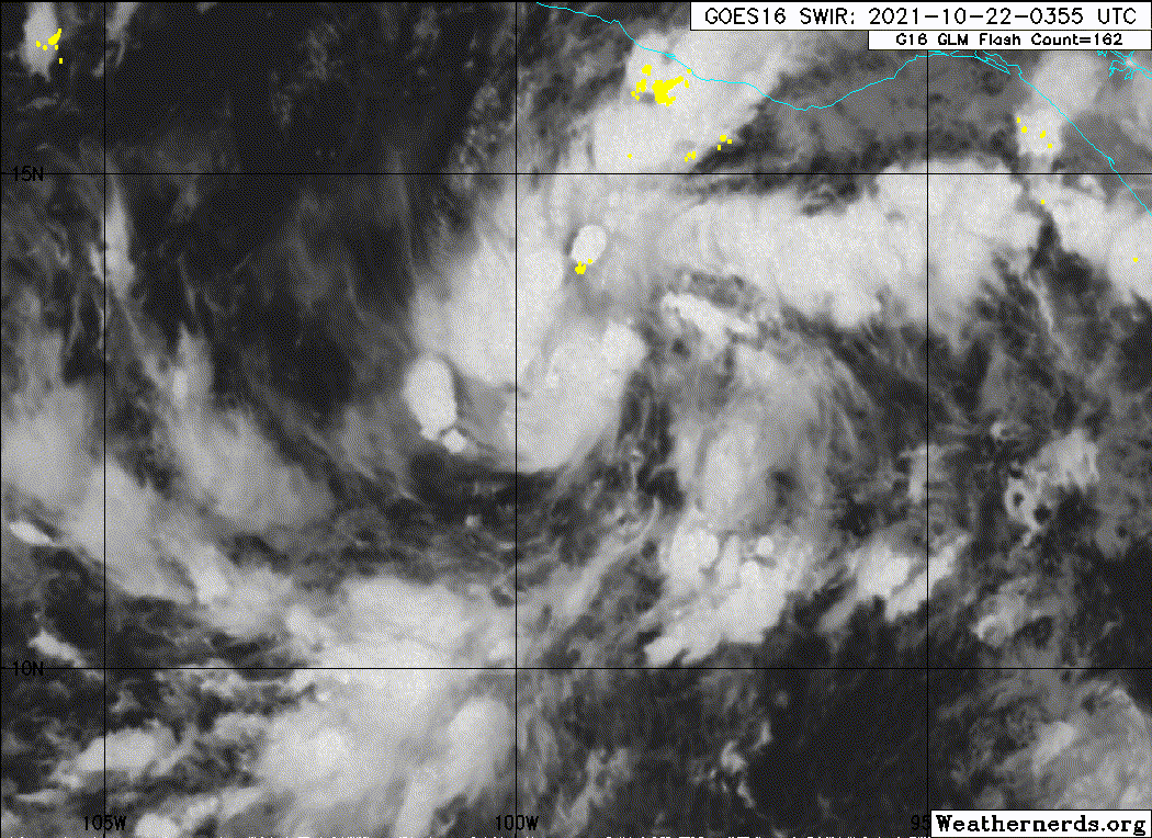
Re: EPAC: INVEST 92E
TXPZ21 KNES 220548
TCSENP
A. TROPICAL DISTURBANCE (92E)
B. 22/0530Z
C. 12.7N
D. 98.9W
E. FIVE/GOES-E
F. T1.5/1.5
G. IR/EIR/SWIR
H. REMARKS...3/10 BANDING RESULTS IN A DT OF 1.5. PT AGREES WHILE MET
IS 1.0. FT IS BASED ON DT.
I. ADDL POSITIONS
NIL
...TURK
TCSENP
A. TROPICAL DISTURBANCE (92E)
B. 22/0530Z
C. 12.7N
D. 98.9W
E. FIVE/GOES-E
F. T1.5/1.5
G. IR/EIR/SWIR
H. REMARKS...3/10 BANDING RESULTS IN A DT OF 1.5. PT AGREES WHILE MET
IS 1.0. FT IS BASED ON DT.
I. ADDL POSITIONS
NIL
...TURK
0 likes
-
Yellow Evan
- Professional-Met
- Posts: 16257
- Age: 27
- Joined: Fri Jul 15, 2011 12:48 pm
- Location: Henderson, Nevada/Honolulu, HI
- Contact:
Re: EPAC: INVEST 92E
000
ABPZ20 KNHC 220511
TWOEP
Tropical Weather Outlook
NWS National Hurricane Center Miami FL
1100 PM PDT Thu Oct 21 2021
For the eastern North Pacific...east of 140 degrees west longitude:
Showers and thunderstorms associated with a low pressure area
located about 250 miles south of Acapulco, Mexico, continue to show
signs of organization, but recent satellite wind data indicate that
the low does not yet have a closed surface wind circulation.
Environmental conditions are expected to be conducive for additional
development, and a tropical depression or tropical storm is expected
to form over the next day or so while moving slowly
west-northwestward or northwestward just offshore the southern coast
of Mexico. Interests along the southern and southwestern coast of
Mexico should monitor the progress of this system during the next
few days, and additional information, including gale warnings, can
be found in High Seas Forecasts issued by the National Weather
Service.
* Formation chance through 48 hours...high...80 percent.
* Formation chance through 5 days...high...90 percent.
&&
High Seas Forecasts issued by the National Weather Service can be
found under AWIPS header NFDHSFEPI, WMO header FZPN02 KWBC, and on
the web at ocean.weather.gov/shtml/NFDHSFEPI.php
$$
Forecaster Berg
0 likes
-
Sciencerocks
- Category 5
- Posts: 10194
- Age: 40
- Joined: Thu Jul 06, 2017 1:51 am
-
Yellow Evan
- Professional-Met
- Posts: 16257
- Age: 27
- Joined: Fri Jul 15, 2011 12:48 pm
- Location: Henderson, Nevada/Honolulu, HI
- Contact:

Who is online
Users browsing this forum: No registered users and 41 guests