
https://twitter.com/philklotzbach/status/1450534371740372992
2021 Indicators: SST's / SAL / MSLP / Shear / Steering / Instability / Sat Images
Moderator: S2k Moderators
Forum rules

The posts in this forum are NOT official forecasts and should not be used as such. They are just the opinion of the poster and may or may not be backed by sound meteorological data. They are NOT endorsed by any professional institution or STORM2K. For official information, please refer to products from the National Hurricane Center and National Weather Service.


Re: 2021 Indicators: SST's / SAL / MSLP / Shear / Steering / Instability / Sat Images
[youtube]https://youtu.be/iyxHg2B9eiI[/youtube]
0 likes
-
AlphaToOmega
- Category 5

- Posts: 1448
- Joined: Sat Jun 26, 2021 10:51 am
- Location: Somewhere in Massachusetts
Re: 2021 Indicators: SST's / SAL / MSLP / Shear / Steering / Instability / Sat Images
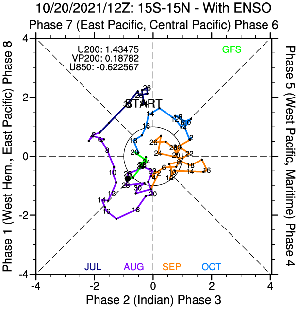
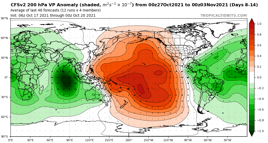
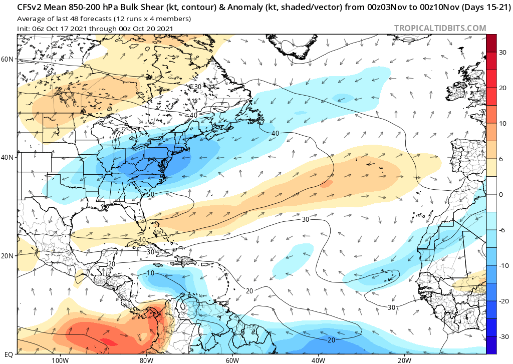
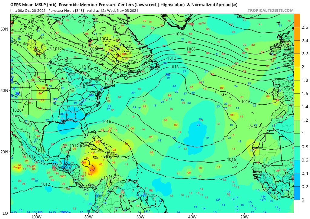
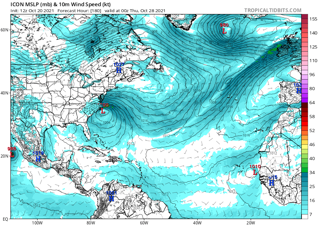
The MJO is forecast to skip Phase VIII and move directly into Phase I. This is shown on the CFSv2 as -VP anomalies throughout the Atlantic, Africa, and the Indian Ocean. As VP anomalies decrease, the Atlantic will likely become more convectively active, and wind shear will likely decrease as well. The CFSv2 also shows the MJO amplifying over the Indian Ocean by mid-November, which might help the Atlantic sustain itself into mid-November. By mid-November, the CFSv2 shows below-average wind shear through the Caribbean and above-average wind shear in the East Pacific, just as a La Nina would entail. Moreover, ensembles are starting to detect favorable conditions. Both the GEFS (American-run) and GEPS (Canadian-run) ensembles foresee favorable conditions within the next few weeks. Even the CFSv2, an American-run climate model, forecasts possible development in the subtropics and in the Caribbean. The ICON also forecasts development by the coast of the Carolinas next week. Specific tracks and intensities are not important; what is important is the general pattern they forecast.

The forecasted patterns also match recent and historical patterns regarding late season activity. For the past couple of hurricane seasons, at least three or more storms have formed each other; in 2017, Nate, Ophelia, and Phillipe formed; in 2018, Michael, Nadine, and Oscar formed; in 2019, Melissa, Nestor, Olga, Pablo, and Rebekah formed; in 2020, Gamma, Delta, Epsilon, and Zeta formed. Additionally, for the past couple of hurricane seasons, at least one hurricane has formed each October; in 2016, Nichole formed; in 2017, Nate and Ophelia formed; in 2018, Michael and Oscar formed; in 2019, Pablo formed; in 2020, Gamma, Delta, Epsilon, and Zeta formed. Historically, every satellite-era season with a positive AMO and either cool-neutral, weak La Nina, or moderate La Nina conditions has featured at least one major hurricane in October: Roxanne (1995); Lili (1996); Iris (2001); Wilma and Beta (2005); Omar (2008); Rina (2011); Nichole (2016); Ophelia (2017); and Delta, Epsilon, and Zeta (2020). Regarding November, every season with a positive AMO and either cool-neutral, weak La Nina, or moderate La Nina conditions since 1996 has featured activity in November; in 1996, Marco formed; in 2001, Noel and Olga formed; in 2005, Gamma, Delta, and Epsilon formed; in 2008, Paloma formed; in 2011, Sean formed; in 2017, Rina formed; in 2020, Eta, Theta, and Iota formed.
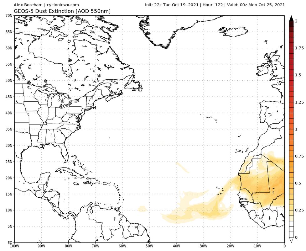
Currently, the base state is favorable for Atlantic tropical cyclogenesis; it has been favorable, and it is expected to continue being favorable. Sea surface temperatures across the Pacific have been below-average, and sea surface temperatures across the North Atlantic have been above-average. Moreover, no dust is forecast to move into the Caribbean. A dust-free, shear-free, convectively active, warm environment is one that is optimal for tropical cyclogenesis. Unlike with the subtropics or the Main Development Region, anything that forms in the Caribbean is bound to impact land. Major hurricanes in the Caribbean during October and November is not just a 2020 phenomenon; and people with interests in the Caribbean should be monitoring the Caribbean, for it will likely soon be ripe for development.
The forecasted patterns also match recent and historical patterns regarding late season activity. For the past couple of hurricane seasons, at least three or more storms have formed each other; in 2017, Nate, Ophelia, and Phillipe formed; in 2018, Michael, Nadine, and Oscar formed; in 2019, Melissa, Nestor, Olga, Pablo, and Rebekah formed; in 2020, Gamma, Delta, Epsilon, and Zeta formed. Additionally, for the past couple of hurricane seasons, at least one hurricane has formed each October; in 2016, Nichole formed; in 2017, Nate and Ophelia formed; in 2018, Michael and Oscar formed; in 2019, Pablo formed; in 2020, Gamma, Delta, Epsilon, and Zeta formed. Historically, every satellite-era season with a positive AMO and either cool-neutral, weak La Nina, or moderate La Nina conditions has featured at least one major hurricane in October: Roxanne (1995); Lili (1996); Iris (2001); Wilma and Beta (2005); Omar (2008); Rina (2011); Nichole (2016); Ophelia (2017); and Delta, Epsilon, and Zeta (2020). Regarding November, every season with a positive AMO and either cool-neutral, weak La Nina, or moderate La Nina conditions since 1996 has featured activity in November; in 1996, Marco formed; in 2001, Noel and Olga formed; in 2005, Gamma, Delta, and Epsilon formed; in 2008, Paloma formed; in 2011, Sean formed; in 2017, Rina formed; in 2020, Eta, Theta, and Iota formed.
Currently, the base state is favorable for Atlantic tropical cyclogenesis; it has been favorable, and it is expected to continue being favorable. Sea surface temperatures across the Pacific have been below-average, and sea surface temperatures across the North Atlantic have been above-average. Moreover, no dust is forecast to move into the Caribbean. A dust-free, shear-free, convectively active, warm environment is one that is optimal for tropical cyclogenesis. Unlike with the subtropics or the Main Development Region, anything that forms in the Caribbean is bound to impact land. Major hurricanes in the Caribbean during October and November is not just a 2020 phenomenon; and people with interests in the Caribbean should be monitoring the Caribbean, for it will likely soon be ripe for development.
2 likes

Re: 2021 Indicators: SST's / SAL / MSLP / Shear / Steering / Instability / Sat Images
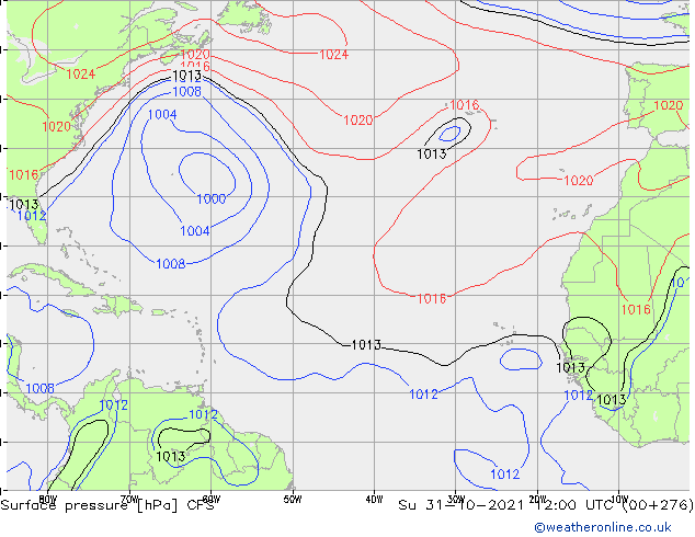
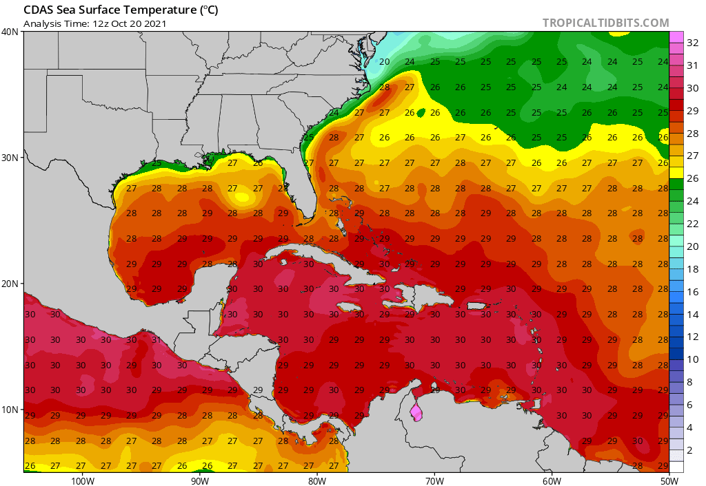
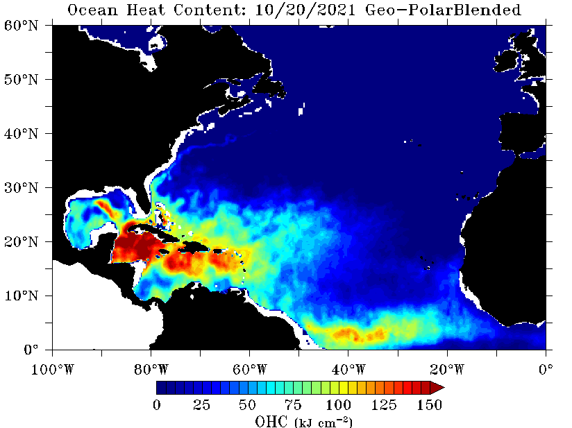
The entire Caribbean has SSTs within the range of 29.5C to 30.5C, and most of the waters there have OHC values of at least 100 kJ*cm. It’s running around +0.8 to +0.9C above average on both the Coral Reef and OISST databases. Clearly, the Caribbean is primed for something to bomb out, but who knows of the late October/early November storm will verify. If it does, it’ll likely be 2021’s last hurrah.
2 likes
Irene '11 Sandy '12 Hermine '16 5/15/2018 Derecho Fay '20 Isaias '20 Elsa '21 Henri '21 Ida '21
I am only a meteorology enthusiast who knows a decent amount about tropical cyclones. Look to the professional mets, the NHC, or your local weather office for the best information.
I am only a meteorology enthusiast who knows a decent amount about tropical cyclones. Look to the professional mets, the NHC, or your local weather office for the best information.
-
AlphaToOmega
- Category 5
- Posts: 1448
- Joined: Sat Jun 26, 2021 10:51 am
- Location: Somewhere in Massachusetts
Re: 2021 Indicators: SST's / SAL / MSLP / Shear / Steering / Instability / Sat Images
aspen wrote:The entire Caribbean has SSTs within the range of 29.5C to 30.5C, and most of the waters there have OHC values of at least 100 kJ*cm. It’s running around +0.8 to +0.9C above average on both the Coral Reef and OISST databases. Clearly, the Caribbean is primed for something to bomb out, but who knows of the late October/early November storm will verify. If it does, it’ll likely be 2021’s last hurrah.
The subtropics are very much open for business in the late season; even though such systems might not impact land, they may impact shipping interests.
0 likes
-
skyline385

- Category 5
- Posts: 2728
- Age: 35
- Joined: Wed Aug 26, 2020 11:15 pm
- Location: Houston TX
Re: 2021 Indicators: SST's / SAL / MSLP / Shear / Steering / Instability / Sat Images
AlphaToOmega wrote:aspen wrote:The entire Caribbean has SSTs within the range of 29.5C to 30.5C, and most of the waters there have OHC values of at least 100 kJ*cm. It’s running around +0.8 to +0.9C above average on both the Coral Reef and OISST databases. Clearly, the Caribbean is primed for something to bomb out, but who knows of the late October/early November storm will verify. If it does, it’ll likely be 2021’s last hurrah.
The subtropics are very much open for business in the late season; even though such systems might not impact land, they may impact shipping interests.
Something to note from your post, models always tend to struggle with shear prediction too far out. You can take any model and it always tends to show shear disappearing when the forecast is 10-15 days out so i think it's way too early to say that shear will be gone mid November.
I am clearly no expert on this but am guessing it has to do with how the natural tendency of a fluid is to reach equilibrium and the models can't predict disturbances which prevent it from happening.
0 likes
-
wxman57

- Moderator-Pro Met

- Posts: 23175
- Age: 68
- Joined: Sat Jun 21, 2003 8:06 pm
- Location: Houston, TX (southwest)
Re: 2021 Indicators: SST's / SAL / MSLP / Shear / Steering / Instability / Sat Images
aspen wrote:The entire Caribbean has SSTs within the range of 29.5C to 30.5C, and most of the waters there have OHC values of at least 100 kJ*cm. It’s running around +0.8 to +0.9C above average on both the Coral Reef and OISST databases. Clearly, the Caribbean is primed for something to bomb out, but who knows of the late October/early November storm will verify. If it does, it’ll likely be 2021’s last hurrah.
Even if the water was boiling, a hurricane won't develop in a high-shear environment. SSTs are typically not the limiting factor in Oct/Nov, wind shear is. MDR is shutting down. Gulf and East Coast are in perpetually high-shear. Any late season storm would form in the SW Caribbean (and into Central America) or in the subtropics, where the NHC could start naming occluded low systems near the Azores next month.
2 likes
-
skyline385
- Category 5
- Posts: 2728
- Age: 35
- Joined: Wed Aug 26, 2020 11:15 pm
- Location: Houston TX
2021 Indicators: SST's / SAL / MSLP / Shear / Steering / Instability / Sat Images
wxman57 wrote:aspen wrote:The entire Caribbean has SSTs within the range of 29.5C to 30.5C, and most of the waters there have OHC values of at least 100 kJ*cm. It’s running around +0.8 to +0.9C above average on both the Coral Reef and OISST databases. Clearly, the Caribbean is primed for something to bomb out, but who knows of the late October/early November storm will verify. If it does, it’ll likely be 2021’s last hurrah.
Even if the water was boiling, a hurricane won't develop in a high-shear environment. SSTs are typically not the limiting factor in Oct/Nov, wind shear is. MDR is shutting down. Gulf and East Coast are in perpetually high-shear. Any late season storm would form in the SW Caribbean (and into Central America) or in the subtropics, where the NHC could start naming occluded low systems near the Azores next month.
A very recent example of this being Pamela, people seem to always discount shear and how hard it is to forecast in long range runs.
2 likes

Re: 2021 Indicators: SST's / SAL / MSLP / Shear / Steering / Instability / Sat Images
0 likes
The above post is not official and should not be used as such. It is the opinion of the poster and may or may not be backed by sound meteorological data. It is not endorsed by any professional institution or storm2k.org. For official information, please refer to the NHC and NWS products.
-
hurricanetrack

- HurricaneTrack.com
- Posts: 1781
- Joined: Tue Dec 02, 2003 10:46 pm
- Location: Wilmington, NC
- Contact:
Re: 2021 Indicators: SST's / SAL / MSLP / Shear / Steering / Instability / Sat Images
Cited one of our own here again - just love the overall knowledge base of the folks here, really helps to get an understanding of what everyone is looking at and how things are progressing when it comes to the tropics.
[youtube]https://youtu.be/paW5VDEb400[/youtube]
[youtube]https://youtu.be/paW5VDEb400[/youtube]
8 likes
-
Category5Kaiju

- Category 5
- Posts: 4334
- Joined: Thu Dec 24, 2020 12:45 pm
- Location: Seattle and Phoenix
Re: 2021 Indicators: SST's / SAL / MSLP / Shear / Steering / Instability / Sat Images
Just as a reminder; there have been very consistent indications that the West Atlantic has been and will continue to remain warmer than average in the near future, and consequently any storm that traverses the warm WCAR waters even early next month would have a lot of fuel to work with. Just because it's November does not mean hurricane season is over or that anything that forms will be weak; as a reminder hurricane season ends on November 30. This is why imho this next potential system early next month should be monitored carefully.


2 likes
Unless explicitly stated, all info in my posts is based on my own opinions and observations. Tropical storms and hurricanes can be extremely dangerous. Refer to an accredited weather research agency or meteorologist if you need to make serious decisions regarding an approaching storm.
-
tolakram
- Admin

- Posts: 20186
- Age: 62
- Joined: Sun Aug 27, 2006 8:23 pm
- Location: Florence, KY (name is Mark)
Re: 2021 Indicators: SST's / SAL / MSLP / Shear / Steering / Instability / Sat Images
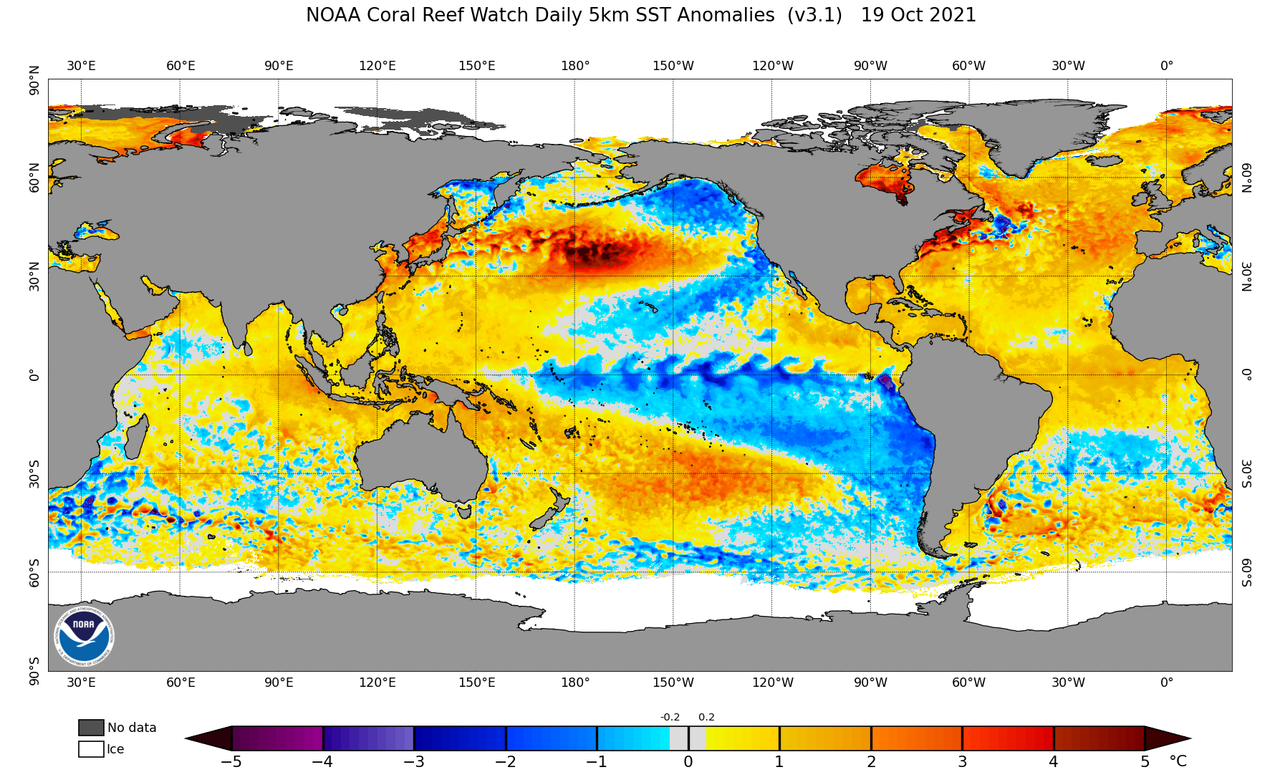
Category5Kaiju wrote:Just as a reminder; there have been very consistent indications that the West Atlantic has been and will continue to remain warmer than average in the near future, and consequently any storm that traverses the warm WCAR waters even early next month would have a lot of fuel to work with. Just because it's November does not mean hurricane season is over or that anything that forms will be weak; as a reminder hurricane season ends on November 30. This is why imho this next potential system early next month should be monitored carefully.
https://coralreefwatch.noaa.gov/data_current/5km/v3.1_op/daily/png/ct5km_ssta_v3.1_tropics_current.png
https://www.tropicaltidbits.com/analysis/ocean/cdas-sflux_sst_atl_1.png
https://www.ospo.noaa.gov/data/ocean/ohc/images/ohc_naQG3_ddc.gif
http://wxmaps.org/pix/atlpot.png
Water temps are fairly meaningless if atmospheric conditions are not conducive for development.
Current shear tendency.

2 likes
M a r k
- - - - -
Join us in chat: Storm2K Chatroom Invite. Android and IOS apps also available.
The posts in this forum are NOT official forecasts and should not be used as such. Posts are NOT endorsed by any professional institution or STORM2K.org. For official information and forecasts, please refer to NHC and NWS products.
Re: 2021 Indicators: SST's / SAL / MSLP / Shear / Steering / Instability / Sat Images
tolakram wrote:Category5Kaiju wrote:Just as a reminder; there have been very consistent indications that the West Atlantic has been and will continue to remain warmer than average in the near future, and consequently any storm that traverses the warm WCAR waters even early next month would have a lot of fuel to work with. Just because it's November does not mean hurricane season is over or that anything that forms will be weak; as a reminder hurricane season ends on November 30. This is why imho this next potential system early next month should be monitored carefully.
https://coralreefwatch.noaa.gov/data_current/5km/v3.1_op/daily/png/ct5km_ssta_v3.1_tropics_current.png
https://www.tropicaltidbits.com/analysis/ocean/cdas-sflux_sst_atl_1.png
https://www.ospo.noaa.gov/data/ocean/ohc/images/ohc_naQG3_ddc.gif
http://wxmaps.org/pix/atlpot.png
Water temps are fairly meaningless if atmospheric conditions are not conducive for development.
Current shear tendency.
https://i.imgur.com/LHqs756.png
It doesn’t make any sense that the atmosphere is unable to support anything in the Atlantic — not even something in the subtropics — when there’s an ongoing La Niña. It makes even less sense that the EPac is now on the verge of a second October hurricane. This is all Niño like, so maybe this is a Modoki La Niña?
0 likes
Irene '11 Sandy '12 Hermine '16 5/15/2018 Derecho Fay '20 Isaias '20 Elsa '21 Henri '21 Ida '21
I am only a meteorology enthusiast who knows a decent amount about tropical cyclones. Look to the professional mets, the NHC, or your local weather office for the best information.
I am only a meteorology enthusiast who knows a decent amount about tropical cyclones. Look to the professional mets, the NHC, or your local weather office for the best information.

Re: 2021 Indicators: SST's / SAL / MSLP / Shear / Steering / Instability / Sat Images
aspen wrote:It doesn’t make any sense that the atmosphere is unable to support anything in the Atlantic — not even something in the subtropics — when there’s an ongoing La Niña. It makes even less sense that the EPac is now on the verge of a second October hurricane. This is all Niño like, so maybe this is a Modoki La Niña?
The upper level winds across the basin have nothing to do with ENSO state. Not to mention, this is not the only late season developing La Nina with high wind shear. 2007 is probably the best analog.
0 likes
Kendall -> SLO -> PBC
Memorable Storms: Katrina (for its Florida landfall...) Wilma Matthew Irma
Memorable Storms: Katrina (for its Florida landfall...) Wilma Matthew Irma
Re: 2021 Indicators: SST's / SAL / MSLP / Shear / Steering / Instability / Sat Images
tolakram wrote:Category5Kaiju wrote:Just as a reminder; there have been very consistent indications that the West Atlantic has been and will continue to remain warmer than average in the near future, and consequently any storm that traverses the warm WCAR waters even early next month would have a lot of fuel to work with. Just because it's November does not mean hurricane season is over or that anything that forms will be weak; as a reminder hurricane season ends on November 30. This is why imho this next potential system early next month should be monitored carefully.
https://coralreefwatch.noaa.gov/data_current/5km/v3.1_op/daily/png/ct5km_ssta_v3.1_tropics_current.png
https://www.tropicaltidbits.com/analysis/ocean/cdas-sflux_sst_atl_1.png
https://www.ospo.noaa.gov/data/ocean/ohc/images/ohc_naQG3_ddc.gif
http://wxmaps.org/pix/atlpot.png
Water temps are fairly meaningless if atmospheric conditions are not conducive for development.
Current shear tendency.
https://i.imgur.com/LHqs756.png
It doesn’t make sense that the atmosphere would be unfavorable for any development in the Atlantic — even some weak subtropical slop — while being totally conductive for two October EPac hurricanes in a La Niña. Maybe this is a Modoki La Niña?
0 likes
Irene '11 Sandy '12 Hermine '16 5/15/2018 Derecho Fay '20 Isaias '20 Elsa '21 Henri '21 Ida '21
I am only a meteorology enthusiast who knows a decent amount about tropical cyclones. Look to the professional mets, the NHC, or your local weather office for the best information.
I am only a meteorology enthusiast who knows a decent amount about tropical cyclones. Look to the professional mets, the NHC, or your local weather office for the best information.
-
Category5Kaiju
- Category 5
- Posts: 4334
- Joined: Thu Dec 24, 2020 12:45 pm
- Location: Seattle and Phoenix
Re: 2021 Indicators: SST's / SAL / MSLP / Shear / Steering / Instability / Sat Images
aspen wrote:tolakram wrote:Category5Kaiju wrote:Just as a reminder; there have been very consistent indications that the West Atlantic has been and will continue to remain warmer than average in the near future, and consequently any storm that traverses the warm WCAR waters even early next month would have a lot of fuel to work with. Just because it's November does not mean hurricane season is over or that anything that forms will be weak; as a reminder hurricane season ends on November 30. This is why imho this next potential system early next month should be monitored carefully.
https://coralreefwatch.noaa.gov/data_current/5km/v3.1_op/daily/png/ct5km_ssta_v3.1_tropics_current.png
https://www.tropicaltidbits.com/analysis/ocean/cdas-sflux_sst_atl_1.png
https://www.ospo.noaa.gov/data/ocean/ohc/images/ohc_naQG3_ddc.gif
http://wxmaps.org/pix/atlpot.png
Water temps are fairly meaningless if atmospheric conditions are not conducive for development.
Current shear tendency.
https://i.imgur.com/LHqs756.png
It doesn’t make any sense that the atmosphere is unable to support anything in the Atlantic — not even something in the subtropics — when there’s an ongoing La Niña. It makes even less sense that the EPac is now on the verge of a second October hurricane. This is all Niño like, so maybe this is a Modoki La Niña?
Weekly sst depature for the 1-2 region looks to be -0.2 C according to the CPC. This is not characteristic of a Modoki La Nina, in a Modoki you would expect the 1-2 region to be decently above average.
0 likes
Unless explicitly stated, all info in my posts is based on my own opinions and observations. Tropical storms and hurricanes can be extremely dangerous. Refer to an accredited weather research agency or meteorologist if you need to make serious decisions regarding an approaching storm.
-
AlphaToOmega
- Category 5
- Posts: 1448
- Joined: Sat Jun 26, 2021 10:51 am
- Location: Somewhere in Massachusetts
Re: 2021 Indicators: SST's / SAL / MSLP / Shear / Steering / Instability / Sat Images
aspen wrote:tolakram wrote:Category5Kaiju wrote:Just as a reminder; there have been very consistent indications that the West Atlantic has been and will continue to remain warmer than average in the near future, and consequently any storm that traverses the warm WCAR waters even early next month would have a lot of fuel to work with. Just because it's November does not mean hurricane season is over or that anything that forms will be weak; as a reminder hurricane season ends on November 30. This is why imho this next potential system early next month should be monitored carefully.
https://coralreefwatch.noaa.gov/data_current/5km/v3.1_op/daily/png/ct5km_ssta_v3.1_tropics_current.png
https://www.tropicaltidbits.com/analysis/ocean/cdas-sflux_sst_atl_1.png
https://www.ospo.noaa.gov/data/ocean/ohc/images/ohc_naQG3_ddc.gif
http://wxmaps.org/pix/atlpot.png
Water temps are fairly meaningless if atmospheric conditions are not conducive for development.
Current shear tendency.
https://i.imgur.com/LHqs756.png
It doesn’t make any sense that the atmosphere is unable to support anything in the Atlantic — not even something in the subtropics — when there’s an ongoing La Niña. It makes even less sense that the EPac is now on the verge of a second October hurricane. This is all Niño like, so maybe this is a Modoki La Niña?
Did you forget about MJO?
1 likes
Re: 2021 Indicators: SST's / SAL / MSLP / Shear / Steering / Instability / Sat Images
AlphaToOmega wrote:aspen wrote:tolakram wrote:
Water temps are fairly meaningless if atmospheric conditions are not conducive for development.
Current shear tendency.
https://i.imgur.com/LHqs756.png
It doesn’t make any sense that the atmosphere is unable to support anything in the Atlantic — not even something in the subtropics — when there’s an ongoing La Niña. It makes even less sense that the EPac is now on the verge of a second October hurricane. This is all Niño like, so maybe this is a Modoki La Niña?
Did you forget about MJO?
The MJO is just about to become favorable so it shouldn’t be an issue. If still nothing develops after the next two weeks or so, it’ll be a greater sign that something is up with the ENSO state.
0 likes
Irene '11 Sandy '12 Hermine '16 5/15/2018 Derecho Fay '20 Isaias '20 Elsa '21 Henri '21 Ida '21
I am only a meteorology enthusiast who knows a decent amount about tropical cyclones. Look to the professional mets, the NHC, or your local weather office for the best information.
I am only a meteorology enthusiast who knows a decent amount about tropical cyclones. Look to the professional mets, the NHC, or your local weather office for the best information.

Re: 2021 Indicators: SST's / SAL / MSLP / Shear / Steering / Instability / Sat Images
I agree that overall activity is down largely as a result of the ENSO state; Perhaps other contributing factors too. As a sidenote, I'm assuming that given the evolving LaNina that the Southern Tier states would probably shift to a relatively warm Winter. As for now though, the SE CONUS sure doesn't appear to be ascribing to that concept with the cool air poised to drop south next week.
0 likes
Andy D
(For official information, please refer to the NHC and NWS products.)
(For official information, please refer to the NHC and NWS products.)
Re: 2021 Indicators: SST's / SAL / MSLP / Shear / Steering / Instability / Sat Images
aspen wrote:The MJO is just about to become favorable so it shouldn’t be an issue. If still nothing develops after the next two weeks or so, it’ll be a greater sign that something is up with the ENSO state.
La Nina is weakening the MJO:
The MJO remained weak over the past few days, as the prior enhanced convective phase continues to destructively interfere with the La Nina base state over the Pacific. Dynamical model MJO index forecasts have begun to highlight a Kelvin wave currently crossing the Western Hemisphere, with many ensemble members from both the GEFS and ECMWF showing amplification over Africa or the Indian Ocean during the next two weeks as the feature evolves into a broader intraseasonal envelope. While considerable uncertainty remains, the Kelvin wave passage and potential Indian Ocean enhancement may provide a window of increased favorability for tropical cyclogenesis across the Atlantic basin over the next two weeks.
Globals have it doubling back into null early November.
0 likes
Kendall -> SLO -> PBC
Memorable Storms: Katrina (for its Florida landfall...) Wilma Matthew Irma
Memorable Storms: Katrina (for its Florida landfall...) Wilma Matthew Irma
Who is online
Users browsing this forum: cycloneye, South Texas Storms and 167 guests