EPAC: RICK - Remnants
Moderator: S2k Moderators
-
Sciencerocks
- Category 5

- Posts: 10181
- Age: 40
- Joined: Thu Jul 06, 2017 1:51 am
-
cycloneye

- Admin

- Posts: 149275
- Age: 69
- Joined: Thu Oct 10, 2002 10:54 am
- Location: San Juan, Puerto Rico
Re: EPAC: RICK - Hurricane
Hurricane Rick Discussion Number 10
NWS National Hurricane Center Miami FL EP172021
400 PM CDT Sun Oct 24 2021
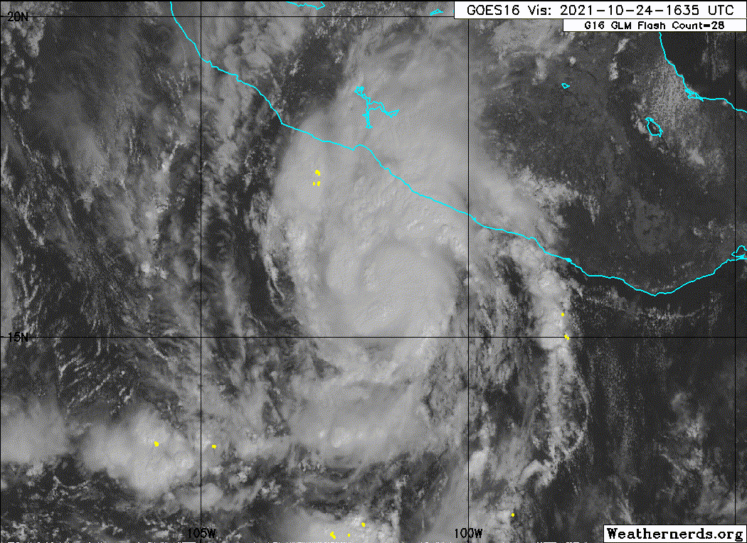
Rick continues to hold its own, with little change in overall
organization over the past 18 to 24 hours. There is still no eye
evident in satellite images, and earlier microwave images revealed
that the eyewall underneath the cirrus canopy is open on the eastern
side. There is a large amount of spread in the various objective
and subjective Dvorak intensity estimates, which range from 60 kt to
90 kt. Since Rick does not look any better or worse than 6 hours
ago, the difference between these estimates is split down the
middle, and the initial advisory intensity remains 75 kt. Based on
data from a 1656 UTC ASCAT-B overpass, winds of tropical storm force
were only 30 n mi from the coast of southwestern Mexico.
A recent ASCAT-B overpass helped to verify the position of the
center of Rick, and the system has been moving a little slower and
to the right of what was previously thought. The initial motion is
therefore set at 360/04 kt. Rick continues to move in the direction
of a weakness in the subtropical ridge. Most of the model guidance
suggest the ridge may begin to fill in slightly to the northeast of
the cyclone as early as tonight, which would cause the hurricane to
turn north-northwestward along with a slight increase in forward
speed. The only notable change to the NHC track forecast was a
slightly slower motion in the short term. Otherwise, the track is
very close to the multimodel consensus solutions.
Rick has been unable to take advantage of the favorable environment
for strengthening over the past 24 hours, and the hurricane is about
out of time to intensify any further. The UW-CIMMS shear analysis
shows 15 to 20 kt of vertical wind shear between Rick and
the coast of Mexico, and 400-700 mb relative humidity of only about
50 percent. Therefore, it is becoming less likely that Rick will
undergo any significant strengthening before landfall. The latest
NHC intensity forecast is lower than the previous one, but remains
on the high end of the guidance. After landfall, the cyclone will
weaken rapidly and the system may dissipate sooner than shown in
this forecast.
Key Messages:
1. Rick is forecast to reach the coast of southern Mexico Monday
morning, bringing life-threatening storm surge and dangerous
hurricane-force winds within a portion of the Hurricane Warning area
from Tecpan de Galeana to Punta San Telmo. Residents in this area
should follow any advice given by local officials.
2. Rick is expected to bring tropical storm conditions to portions
of the southern and southwestern coasts of Mexico beginning within
the next couple of hours from east of Tecpan de Galeana to Acapulco,
and by Monday morning from west of Punta San Telmo to Manzanillo,
where a Tropical Storm Warning is in effect.
3. Heavy rains associated with Rick are expected to spread across
the Mexican states of Guerrero and Michoacan through tonight, and
could persist through Tuesday. This rainfall will likely produce
flash flooding and mudslides.
FORECAST POSITIONS AND MAX WINDS
INIT 24/2100Z 16.3N 101.7W 75 KT 85 MPH
12H 25/0600Z 17.1N 101.9W 80 KT 90 MPH...NEAR COAST
24H 25/1800Z 18.4N 102.6W 50 KT 60 MPH...INLAND
36H 26/0600Z 19.6N 103.4W 25 KT 30 MPH...INLAND
48H 26/1800Z...DISSIPATED
$$
Forecaster Latto/Pasch
NWS National Hurricane Center Miami FL EP172021
400 PM CDT Sun Oct 24 2021
Rick continues to hold its own, with little change in overall
organization over the past 18 to 24 hours. There is still no eye
evident in satellite images, and earlier microwave images revealed
that the eyewall underneath the cirrus canopy is open on the eastern
side. There is a large amount of spread in the various objective
and subjective Dvorak intensity estimates, which range from 60 kt to
90 kt. Since Rick does not look any better or worse than 6 hours
ago, the difference between these estimates is split down the
middle, and the initial advisory intensity remains 75 kt. Based on
data from a 1656 UTC ASCAT-B overpass, winds of tropical storm force
were only 30 n mi from the coast of southwestern Mexico.
A recent ASCAT-B overpass helped to verify the position of the
center of Rick, and the system has been moving a little slower and
to the right of what was previously thought. The initial motion is
therefore set at 360/04 kt. Rick continues to move in the direction
of a weakness in the subtropical ridge. Most of the model guidance
suggest the ridge may begin to fill in slightly to the northeast of
the cyclone as early as tonight, which would cause the hurricane to
turn north-northwestward along with a slight increase in forward
speed. The only notable change to the NHC track forecast was a
slightly slower motion in the short term. Otherwise, the track is
very close to the multimodel consensus solutions.
Rick has been unable to take advantage of the favorable environment
for strengthening over the past 24 hours, and the hurricane is about
out of time to intensify any further. The UW-CIMMS shear analysis
shows 15 to 20 kt of vertical wind shear between Rick and
the coast of Mexico, and 400-700 mb relative humidity of only about
50 percent. Therefore, it is becoming less likely that Rick will
undergo any significant strengthening before landfall. The latest
NHC intensity forecast is lower than the previous one, but remains
on the high end of the guidance. After landfall, the cyclone will
weaken rapidly and the system may dissipate sooner than shown in
this forecast.
Key Messages:
1. Rick is forecast to reach the coast of southern Mexico Monday
morning, bringing life-threatening storm surge and dangerous
hurricane-force winds within a portion of the Hurricane Warning area
from Tecpan de Galeana to Punta San Telmo. Residents in this area
should follow any advice given by local officials.
2. Rick is expected to bring tropical storm conditions to portions
of the southern and southwestern coasts of Mexico beginning within
the next couple of hours from east of Tecpan de Galeana to Acapulco,
and by Monday morning from west of Punta San Telmo to Manzanillo,
where a Tropical Storm Warning is in effect.
3. Heavy rains associated with Rick are expected to spread across
the Mexican states of Guerrero and Michoacan through tonight, and
could persist through Tuesday. This rainfall will likely produce
flash flooding and mudslides.
FORECAST POSITIONS AND MAX WINDS
INIT 24/2100Z 16.3N 101.7W 75 KT 85 MPH
12H 25/0600Z 17.1N 101.9W 80 KT 90 MPH...NEAR COAST
24H 25/1800Z 18.4N 102.6W 50 KT 60 MPH...INLAND
36H 26/0600Z 19.6N 103.4W 25 KT 30 MPH...INLAND
48H 26/1800Z...DISSIPATED
$$
Forecaster Latto/Pasch
0 likes
Visit the Caribbean-Central America Weather Thread where you can find at first post web cams,radars
and observations from Caribbean basin members Click Here
and observations from Caribbean basin members Click Here
-
Yellow Evan

- Professional-Met

- Posts: 16231
- Age: 27
- Joined: Fri Jul 15, 2011 12:48 pm
- Location: Henderson, Nevada/Honolulu, HI
- Contact:
Re: EPAC: RICK - Hurricane
Westerly mid-level winds with southerly upper level winds (due to a displaced ULAC to its east) and a storm moving generally northward isn’t the best combination.
0 likes
-
tolakram
- Admin
- Posts: 20178
- Age: 62
- Joined: Sun Aug 27, 2006 8:23 pm
- Location: Florence, KY (name is Mark)
Re: EPAC: RICK - Hurricane
COD floater https://weather.cod.edu/satrad/?parms=meso-meso1-02-200-1-100-1&checked=map&colorbar=undefined
0 likes
M a r k
- - - - -
Join us in chat: Storm2K Chatroom Invite. Android and IOS apps also available.
The posts in this forum are NOT official forecasts and should not be used as such. Posts are NOT endorsed by any professional institution or STORM2K.org. For official information and forecasts, please refer to NHC and NWS products.

Re: EPAC: RICK - Hurricane
Eye is a fair bit larger than before so maybe the dry air and shear induced an odd sort of ERC. Improved from this morning.

The UW-CIMMS shear analysis
shows 15 to 20 kt of vertical wind shear between Rick and
the coast of Mexico, and 400-700 mb relative humidity of only about
50 percent.
shows 15 to 20 kt of vertical wind shear between Rick and
the coast of Mexico, and 400-700 mb relative humidity of only about
50 percent.
2 likes
Kendall -> SLO -> PBC
Memorable Storms: Katrina (for its Florida landfall...) Wilma Matthew Irma
Memorable Storms: Katrina (for its Florida landfall...) Wilma Matthew Irma
Re: EPAC: RICK - Hurricane

0 likes
Kendall -> SLO -> PBC
Memorable Storms: Katrina (for its Florida landfall...) Wilma Matthew Irma
Memorable Storms: Katrina (for its Florida landfall...) Wilma Matthew Irma
-
Yellow Evan
- Professional-Met
- Posts: 16231
- Age: 27
- Joined: Fri Jul 15, 2011 12:48 pm
- Location: Henderson, Nevada/Honolulu, HI
- Contact:
Re: EPAC: RICK - Hurricane
Clear improvement on microwave but convection still have issues rotating around.
0 likes
Re: EPAC: RICK - Hurricane
Up to 80kt
000
WTPZ32 KNHC 242349
TCPEP2
BULLETIN
Hurricane Rick Intermediate Advisory Number 10A
NWS National Hurricane Center Miami FL EP172021
700 PM CDT Sun Oct 24 2021
...RICK GETTING A LITTLE BETTER ORGANIZED WHILE MOVING SLOWLY
TOWARD THE COAST OF MEXICO...
...TROPICAL STORM CONDITIONS SPREADING ONSHORE SOUTHERN MEXICO...
SUMMARY OF 700 PM CDT...0000 UTC...INFORMATION
----------------------------------------------
LOCATION...16.5N 101.6W
ABOUT 85 MI...135 KM S OF ZIHUATANEJO MEXICO
ABOUT 115 MI...190 KM SSE OF LAZARO CARDENAS MEXICO
MAXIMUM SUSTAINED WINDS...90 MPH...150 KM/H
PRESENT MOVEMENT...N OR 360 DEGREES AT 5 MPH...7 KM/H
MINIMUM CENTRAL PRESSURE...977 MB...28.85 INCHES
0 likes
Kendall -> SLO -> PBC
Memorable Storms: Katrina (for its Florida landfall...) Wilma Matthew Irma
Memorable Storms: Katrina (for its Florida landfall...) Wilma Matthew Irma

Re: EPAC: RICK - Hurricane
Recon will be arriving at the perfect time to see how much Rick is trying to intensify. Its convective structure looks a little better too, with some signs of an eye, a better CDO, and a new massive hot tower firing over the LLC.
1 likes
Irene '11 Sandy '12 Hermine '16 5/15/2018 Derecho Fay '20 Isaias '20 Elsa '21 Henri '21 Ida '21
I am only a meteorology enthusiast who knows a decent amount about tropical cyclones. Look to the professional mets, the NHC, or your local weather office for the best information.
I am only a meteorology enthusiast who knows a decent amount about tropical cyclones. Look to the professional mets, the NHC, or your local weather office for the best information.
-
Yellow Evan
- Professional-Met
- Posts: 16231
- Age: 27
- Joined: Fri Jul 15, 2011 12:48 pm
- Location: Henderson, Nevada/Honolulu, HI
- Contact:
-
Hurricane2021
- Tropical Storm

- Posts: 108
- Age: 33
- Joined: Mon Jul 05, 2021 2:54 pm
- Contact:
-
Yellow Evan
- Professional-Met
- Posts: 16231
- Age: 27
- Joined: Fri Jul 15, 2011 12:48 pm
- Location: Henderson, Nevada/Honolulu, HI
- Contact:

Re: EPAC: RICK - Hurricane
Looks much better than even a few hours ago. This is starting to give me Grace vibes as I thought earlier today, but thankfully at a lower intensity.
0 likes
TC naming lists: retirements and intensity
Most aggressive Advisory #1's in North Atlantic (cr. kevin for starting the list)
Most aggressive Advisory #1's in North Atlantic (cr. kevin for starting the list)
-
cycloneye
- Admin
- Posts: 149275
- Age: 69
- Joined: Thu Oct 10, 2002 10:54 am
- Location: San Juan, Puerto Rico
Re: EPAC: RICK - Hurricane
Hurricane2021 wrote:When The recon will depart from the base?
Just departed.

1 likes
Visit the Caribbean-Central America Weather Thread where you can find at first post web cams,radars
and observations from Caribbean basin members Click Here
and observations from Caribbean basin members Click Here
-
zeehag
- Tropical Storm
- Posts: 181
- Age: 77
- Joined: Sun Jul 17, 2011 9:49 pm
- Location: mazatlan,sinaloa, mexico, fixing patricia's mess.
- Contact:
Re: EPAC: RICK - Hurricane
judging by coordinates this issue will present closer to zihuatenejo's playa principal, 17.6386° N, 101.5571° W, than lazaro Cardenas, 17.9568° N, 102.1943° W.
this will be interesting for the residents of zihuat bay. i hope they donot experience much damages from this. should pass closer to them than pamela did us in mazatlan..and we could spit in her eye.
this will be interesting for the residents of zihuat bay. i hope they donot experience much damages from this. should pass closer to them than pamela did us in mazatlan..and we could spit in her eye.
0 likes
-
Sciencerocks
- Category 5
- Posts: 10181
- Age: 40
- Joined: Thu Jul 06, 2017 1:51 am
-
cycloneye
- Admin
- Posts: 149275
- Age: 69
- Joined: Thu Oct 10, 2002 10:54 am
- Location: San Juan, Puerto Rico
Re: EPAC: RICK - Hurricane
0 likes
Visit the Caribbean-Central America Weather Thread where you can find at first post web cams,radars
and observations from Caribbean basin members Click Here
and observations from Caribbean basin members Click Here
-
cycloneye
- Admin
- Posts: 149275
- Age: 69
- Joined: Thu Oct 10, 2002 10:54 am
- Location: San Juan, Puerto Rico
Re: EPAC: RICK - Hurricane
BULLETIN
Hurricane Rick Advisory Number 11
NWS National Hurricane Center Miami FL EP172021
1000 PM CDT Sun Oct 24 2021
...RICK CONTINUING TO GET BETTER ORGANIZED AS IT MOVES CLOSER TO
THE MEXICAN COAST...
...STRONG GUSTY WINDS AND HEAVY RAINS SPREADING ACROSS THE COASTAL
WARNING AREAS OF SOUTHERN MEXICO...
SUMMARY OF 1000 PM CDT...0300 UTC...INFORMATION
-----------------------------------------------
LOCATION...16.8N 101.6W
ABOUT 60 MI...100 KM S OF ZIHUATANEJO MEXICO
ABOUT 90 MI...150 KM SSE OF LAZARO CARDENAS MEXICO
MAXIMUM SUSTAINED WINDS...90 MPH...150 KM/H
PRESENT MOVEMENT...N OR 360 DEGREES AT 6 MPH...9 KM/H
MINIMUM CENTRAL PRESSURE...977 MB...28.85 INCHES
Hurricane Rick Discussion Number 11
NWS National Hurricane Center Miami FL EP172021
1000 PM CDT Sun Oct 24 2021
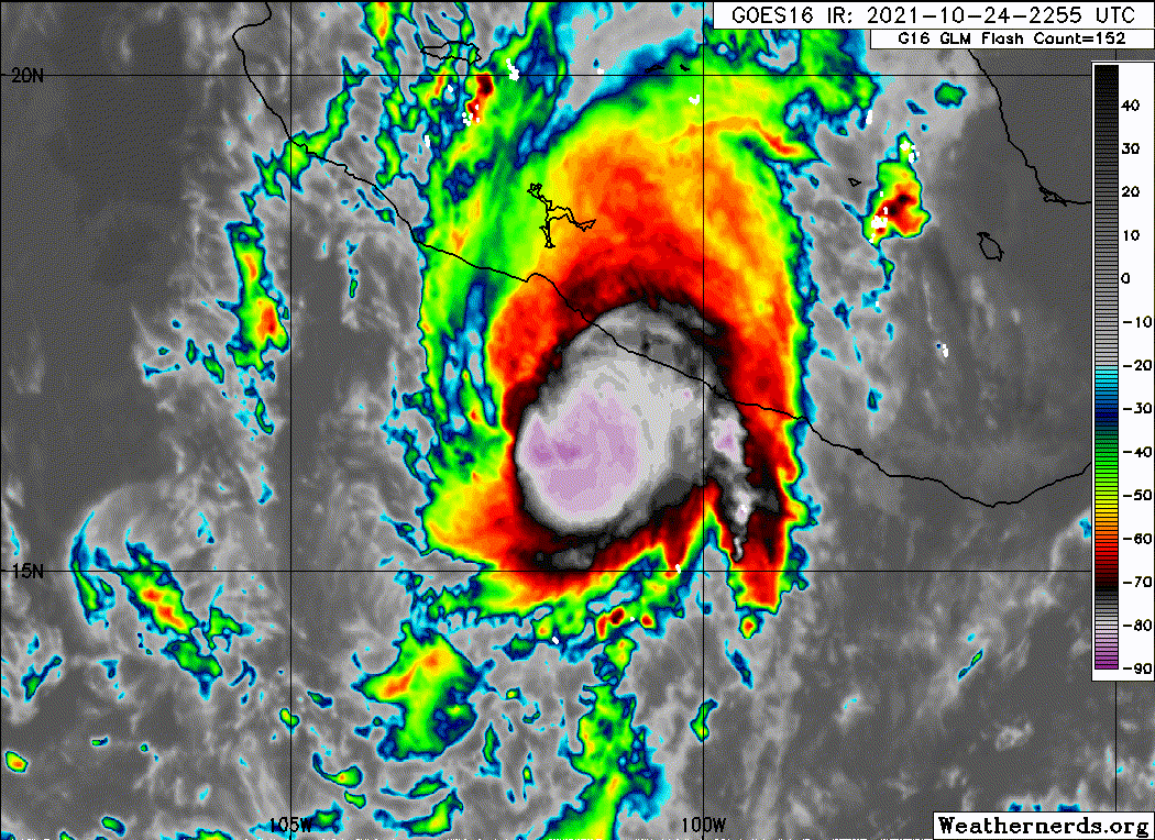
Rick's convective organization and inner-core structure have both
continued to improve since the previous advisory. GMI and SSMI/S
passive microwave satellite data at 2245Z and 2310Z, respectively,
revealed that the hurricane had redeveloped a 20-nmi-wide low- and
mid-level closed eye that was surrounded by a solid ring of intense
convection. With better center placement now, satellite intensity
estimates using an embedded center technique indicate that Rick is
just below the T5.0/90-kt intensity classification threshold. Based
on these data, the intensity was increased to 80 kt at 0000 UTC and
has been held at that value at the advisory time due to no
appreciable change in Rick's appearance in infrared satellite
imagery. An Air Force Reserve reconnaissance aircraft is currently
enroute to provide a better assessment of Rick's intensity and
compact wind field structure around 0600 UTC.
The aforementioned GMI and SSMI/S microwave satellite data, compared
to earlier microwave imagery, indicate that Rick's eye/center has
been moving due north over the past 9 hours, or 360/05 kt. The
hurricane is currently located to the right or east of the previous
forecast track and model guidance, and only the new GFS model run
is on the right side of the latest track guidance envelope. The new
NHC track forecast has been nudged a little to the right of the
previous track, but not quite as far east as the northward-moving
GFS model scenario since the bulk of the other track forecasts
still show Rick making a turn toward the north-northwest during the
next 6 hours. The subtropical ridge steering the hurricane is
forecast to remain in place for the next 36 hours, which should
result in Rick making landfall in about 12 h, with the cyclone
dissipating in 36-48 h over the mountainous interior of
south-central or central Mexico.
The deep-layer vertical shear across Rick is forecast to increase
to 15-18 kt in 12 h. However, the shear direction is going to be
from the south, which be along rather across Rick's forward motion,
thus lessening the otherwise adverse effects of the increasing
shear. As a result, some slight strengthening will be possible
until the hurricane makes landfall late Monday morning. The latest
NHC intensity forecast is slightly higher than the previous
advisory, but a 5-kt increase is easily within NHC's statistical
range of intensity forecast skill. After landfall occurs, Rick
should rapidly weaken due to the hurricane's relatively slow
forward motion over the very rugged terrain of south-central and
central Mexico. In fact, it wouldn't be surprising if the hurricane
dissipated sooner than indicated in the official intensity forecast.
However, very heavy rainfall causing dangerous flash flooding and
mudslides will still continue well after Rick dissipates as a
tropical cyclone owing to persistent, moist southerly onshore flow
being lifted by the mountainous topography.
Key Messages:
1. Rick is forecast to reach the coast of southern Mexico by late
Monday morning, bringing life-threatening storm surge and dangerous
hurricane-force winds within a portion of the Hurricane Warning area
from Tecpan de Galeana to Punta San Telmo. Residents in this area
should follow any advice given by local officials.
2. Rick is expected to continue bringing tropical storm conditions
to portions of the southern coast of Mexico from east of Tecpan de
Galeana to Acapulco, and by Monday morning from west of Punta San
Telmo to Manzanillo, where a Tropical Storm Warning is in effect.
3. Heavy rains associated with Rick are expected to spread across
the Mexican states of Guerrero and Michoacan through tonight, and
could persist through Tuesday. This rainfall will likely produce
dangerous flash flooding and mudslides.
FORECAST POSITIONS AND MAX WINDS
INIT 25/0300Z 16.8N 101.6W 80 KT 90 MPH
12H 25/1200Z 17.7N 101.9W 85 KT 100 MPH
24H 26/0000Z 18.7N 102.3W 45 KT 50 MPH...INLAND
36H 26/1200Z 19.6N 102.9W 20 KT 25 MPH...INLAND
48H 27/0000Z...DISSIPATED
$$
Forecaster Stewart
Hurricane Rick Advisory Number 11
NWS National Hurricane Center Miami FL EP172021
1000 PM CDT Sun Oct 24 2021
...RICK CONTINUING TO GET BETTER ORGANIZED AS IT MOVES CLOSER TO
THE MEXICAN COAST...
...STRONG GUSTY WINDS AND HEAVY RAINS SPREADING ACROSS THE COASTAL
WARNING AREAS OF SOUTHERN MEXICO...
SUMMARY OF 1000 PM CDT...0300 UTC...INFORMATION
-----------------------------------------------
LOCATION...16.8N 101.6W
ABOUT 60 MI...100 KM S OF ZIHUATANEJO MEXICO
ABOUT 90 MI...150 KM SSE OF LAZARO CARDENAS MEXICO
MAXIMUM SUSTAINED WINDS...90 MPH...150 KM/H
PRESENT MOVEMENT...N OR 360 DEGREES AT 6 MPH...9 KM/H
MINIMUM CENTRAL PRESSURE...977 MB...28.85 INCHES
Hurricane Rick Discussion Number 11
NWS National Hurricane Center Miami FL EP172021
1000 PM CDT Sun Oct 24 2021
Rick's convective organization and inner-core structure have both
continued to improve since the previous advisory. GMI and SSMI/S
passive microwave satellite data at 2245Z and 2310Z, respectively,
revealed that the hurricane had redeveloped a 20-nmi-wide low- and
mid-level closed eye that was surrounded by a solid ring of intense
convection. With better center placement now, satellite intensity
estimates using an embedded center technique indicate that Rick is
just below the T5.0/90-kt intensity classification threshold. Based
on these data, the intensity was increased to 80 kt at 0000 UTC and
has been held at that value at the advisory time due to no
appreciable change in Rick's appearance in infrared satellite
imagery. An Air Force Reserve reconnaissance aircraft is currently
enroute to provide a better assessment of Rick's intensity and
compact wind field structure around 0600 UTC.
The aforementioned GMI and SSMI/S microwave satellite data, compared
to earlier microwave imagery, indicate that Rick's eye/center has
been moving due north over the past 9 hours, or 360/05 kt. The
hurricane is currently located to the right or east of the previous
forecast track and model guidance, and only the new GFS model run
is on the right side of the latest track guidance envelope. The new
NHC track forecast has been nudged a little to the right of the
previous track, but not quite as far east as the northward-moving
GFS model scenario since the bulk of the other track forecasts
still show Rick making a turn toward the north-northwest during the
next 6 hours. The subtropical ridge steering the hurricane is
forecast to remain in place for the next 36 hours, which should
result in Rick making landfall in about 12 h, with the cyclone
dissipating in 36-48 h over the mountainous interior of
south-central or central Mexico.
The deep-layer vertical shear across Rick is forecast to increase
to 15-18 kt in 12 h. However, the shear direction is going to be
from the south, which be along rather across Rick's forward motion,
thus lessening the otherwise adverse effects of the increasing
shear. As a result, some slight strengthening will be possible
until the hurricane makes landfall late Monday morning. The latest
NHC intensity forecast is slightly higher than the previous
advisory, but a 5-kt increase is easily within NHC's statistical
range of intensity forecast skill. After landfall occurs, Rick
should rapidly weaken due to the hurricane's relatively slow
forward motion over the very rugged terrain of south-central and
central Mexico. In fact, it wouldn't be surprising if the hurricane
dissipated sooner than indicated in the official intensity forecast.
However, very heavy rainfall causing dangerous flash flooding and
mudslides will still continue well after Rick dissipates as a
tropical cyclone owing to persistent, moist southerly onshore flow
being lifted by the mountainous topography.
Key Messages:
1. Rick is forecast to reach the coast of southern Mexico by late
Monday morning, bringing life-threatening storm surge and dangerous
hurricane-force winds within a portion of the Hurricane Warning area
from Tecpan de Galeana to Punta San Telmo. Residents in this area
should follow any advice given by local officials.
2. Rick is expected to continue bringing tropical storm conditions
to portions of the southern coast of Mexico from east of Tecpan de
Galeana to Acapulco, and by Monday morning from west of Punta San
Telmo to Manzanillo, where a Tropical Storm Warning is in effect.
3. Heavy rains associated with Rick are expected to spread across
the Mexican states of Guerrero and Michoacan through tonight, and
could persist through Tuesday. This rainfall will likely produce
dangerous flash flooding and mudslides.
FORECAST POSITIONS AND MAX WINDS
INIT 25/0300Z 16.8N 101.6W 80 KT 90 MPH
12H 25/1200Z 17.7N 101.9W 85 KT 100 MPH
24H 26/0000Z 18.7N 102.3W 45 KT 50 MPH...INLAND
36H 26/1200Z 19.6N 102.9W 20 KT 25 MPH...INLAND
48H 27/0000Z...DISSIPATED
$$
Forecaster Stewart
0 likes
Visit the Caribbean-Central America Weather Thread where you can find at first post web cams,radars
and observations from Caribbean basin members Click Here
and observations from Caribbean basin members Click Here
-
Yellow Evan
- Professional-Met
- Posts: 16231
- Age: 27
- Joined: Fri Jul 15, 2011 12:48 pm
- Location: Henderson, Nevada/Honolulu, HI
- Contact:
-
Yellow Evan
- Professional-Met
- Posts: 16231
- Age: 27
- Joined: Fri Jul 15, 2011 12:48 pm
- Location: Henderson, Nevada/Honolulu, HI
- Contact:
Who is online
Users browsing this forum: No registered users and 21 guests