MarioProtVI wrote:Shell Mound wrote:This thread is a bit similar to
this one. In the latter I attempted to delineate the most realistic “ceiling” for a hyperactive Atlantic season in terms of overall intensity and impact(s). As far as ACE generated seasonally and over land is concerned, by all available indications the
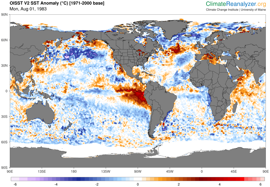
1933 season was one of the most extreme on record. It likely featured at least eight major hurricanes and multiple long-trackers in the MDR and Caribbean, including two (plausible) Category-4 impacts on the CONUS within 24h of each other. Not only was the season likely on a par with 2005 in terms of overall NS, but it also featured a strong westward bias in its tracks, to not mention extremely high ACE that is almost certainly underestimated. 1933’s parameters in the deep tropics—including ENSO, MSLP, and low vertical wind shear—actually surpassed 2005’s, and its SST in the MDR and Caribbean were comparable. Had 1933 occurred today, we would likely be talking about how it surpassed 2005 in virtually all areas, especially in terms of a CV season.
As far as scenario number two is concerned, a number of seasons in the late 1800s met those criteria. For instance, look at the SST configuration in 1878:
https://i.ibb.co/PD7tR8S/1878-ASOSSTA-1.png The outcome, per
preliminary reanalysis (map courtesy of
TheAustinMan):
https://i.imgur.com/KrgJ1Ur.png Note that, per reanalysis, 1878 featured a 130-kt, 927-mb Category 4 in the central MDR during mid to late October.
How the hell 1878 managed to basically get a Lorenzo/Sam-like storm in a time period where the MDR is basically done for the season with high wind shear being established is beyond my understanding if this reanalysis is correct. Record warm MDR? Record breaking MJO pulse that reduced wind shear by an unusually historic amount in that area? That is probably the biggest anomaly I’ve ever seen and probably more so then Tomas 2010 reaching C2 on the extreme western edge of the MDR in late October.
The reanalysed best track for 1851–98 can be found
here. Simply click on “Supplementary Materials” and then click on the ZIP file (the revised HURDAT should be in Excel-type format). In general, the late nineteenth century featured a number of seasons with
record-low vertical wind shear, combined with a robust +AMO and -ENSO, as the
SST configuration for 1878 alone, posted previously, implied:
In addition to the increased uncertainty early in the record, we note that 20CRv3 also identifies extremely low vertical wind shear in the late 1800s—a time period which had several very active Atlantic hurricane seasons, especially 1878, 1886, 1887, and 1893.
According to the revised data, Storm #14 (previously #10) of 1878 attained TS status at 18.2°N 19.2°W at 12:00 UTC on 10 October. The TC became a hurricane one day later, at 18.6°N 25°W, just before a ship registered a central MSLP of 979 mb. At 06:00 UTC on 14 October, while the storm was centred at 17.6°N 41.1°W, a ship at an unknown distance from the eye recorded a MSLP of 948 mb, suggesting MSW of ≥ 115 kt, per P/W relationships (the BT file lists 100 kt at that point, but P/W would suggest an even higher MSW value). At 00:00 UTC on 17 October, while the TC was centred near 22.3°N 47.5°W, yet another ship at an unknown distance from the eye registered a MSLP of 927 mb, indicating MSW of ≥ 130 kt. At 12:00 UTC on 18 October a fourth ship measured a MSLP of 951 mb in the eye, which is consistent with the other observations mentioned thus far, so the available observations do appear to support the existence of a powerful MH in the east-central MDR during mid to late October of 1878.