

2021 Indicators: SST's / SAL / MSLP / Shear / Steering / Instability / Sat Images
Moderator: S2k Moderators
Forum rules

The posts in this forum are NOT official forecasts and should not be used as such. They are just the opinion of the poster and may or may not be backed by sound meteorological data. They are NOT endorsed by any professional institution or STORM2K. For official information, please refer to products from the National Hurricane Center and National Weather Service.
Re: 2021 Indicators: SST's / SAL / MSLP / Shear / Steering / Instability / Sat Images
From the CPC:
3 likes
Kendall -> SLO -> PBC
Memorable Storms: Katrina (for its Florida landfall...) Wilma Matthew Irma
Memorable Storms: Katrina (for its Florida landfall...) Wilma Matthew Irma

Re: 2021 Indicators: SST's / SAL / MSLP / Shear / Steering / Instability / Sat Images
Ubuntwo wrote:tolakram wrote:I don't think it's really that big of a deal. ENSO, shear, MJO, water temps, kelvin waves, these are all modifiers for chance of development and strength of storms, but there are still plenty of variables that, when missing, reduce development chances by an unknown amount.
Every season is different for a reason, and sometimes those reasons are not known in advance. If we end up with a super active November we might look back at this and put more stock into the idea of a delayed season rather than one that mysteriously shut down. If not, then perhaps the Atlantic nino, which I had never heard of until this year, might be to blame.
Could easily see a pattern change in November allowing more activity. Regardless, the October lull is interesting and rare for a year like 2021. May be worth looking back in post with better data. The late developing La Nina, long lasting Atlantic Nino, low latitude ridging, and persistent upper trough all may have played some role.
2007 keeps cropping up as an analog:
https://twitter.com/philklotzbach/status/1453093102822912004
The combo of these features together to limit activity in the Atlantic and allow for landfalling EPac hurricanes — the opposite of what the ENSO state would suggest — has been extremely unusual and uncharacteristic of this recent active stretch since 2016. Could just be a rare alignment, or it could be a sign of a changing background state.
0 likes
Irene '11 Sandy '12 Hermine '16 5/15/2018 Derecho Fay '20 Isaias '20 Elsa '21 Henri '21 Ida '21
I am only a meteorology enthusiast who knows a decent amount about tropical cyclones. Look to the professional mets, the NHC, or your local weather office for the best information.
I am only a meteorology enthusiast who knows a decent amount about tropical cyclones. Look to the professional mets, the NHC, or your local weather office for the best information.
-
Category5Kaiju

- Category 5

- Posts: 4336
- Joined: Thu Dec 24, 2020 12:45 pm
- Location: Seattle during the summer, Phoenix during the winter
Re: 2021 Indicators: SST's / SAL / MSLP / Shear / Steering / Instability / Sat Images
Whatever happens going forward, looks like we’re going to need to do a great deal of retrospective study on why this year’s late season has so far featured 0 NSs (not to mention global inactivity earlier this month)
Also worth noting we have yet to see a major strength cyclone anywhere in the world since very early this month.
Also worth noting we have yet to see a major strength cyclone anywhere in the world since very early this month.
1 likes
Unless explicitly stated, all information in my posts is based on my own opinions and observations. Tropical storms and hurricanes can be extremely dangerous. Refer to an accredited weather research agency or meteorologist if you need to make serious decisions regarding an approaching storm.
-
AlphaToOmega
- Category 5
- Posts: 1448
- Joined: Sat Jun 26, 2021 10:51 am
- Location: Somewhere in Massachusetts
Re: 2021 Indicators: SST's / SAL / MSLP / Shear / Steering / Instability / Sat Images
The CFSv2 and EPS are showing strong -VP signals over the Indian Ocean into mid-November, which favors the Atlantic.
1 likes
-
Category5Kaiju
- Category 5
- Posts: 4336
- Joined: Thu Dec 24, 2020 12:45 pm
- Location: Seattle during the summer, Phoenix during the winter
Re: 2021 Indicators: SST's / SAL / MSLP / Shear / Steering / Instability / Sat Images
Hypothetically speaking, if we get no NSs from here on out, imagine how short the annual NOAA hurricane season timelapse video would be when it comes out later this year or next 
1 likes
Unless explicitly stated, all information in my posts is based on my own opinions and observations. Tropical storms and hurricanes can be extremely dangerous. Refer to an accredited weather research agency or meteorologist if you need to make serious decisions regarding an approaching storm.

Re: 2021 Indicators: SST's / SAL / MSLP / Shear / Steering / Instability / Sat Images
https://twitter.com/AndyHazelton/status/1452987236799193095
https://twitter.com/AndyHazelton/status/1453026335887175689
https://twitter.com/AndyHazelton/status/1453026335887175689
1 likes
TC naming lists: retirements and intensity
Most aggressive Advisory #1's in North Atlantic (cr. kevin for starting the list)
Most aggressive Advisory #1's in North Atlantic (cr. kevin for starting the list)
-
Category5Kaiju
- Category 5
- Posts: 4336
- Joined: Thu Dec 24, 2020 12:45 pm
- Location: Seattle during the summer, Phoenix during the winter
Re: 2021 Indicators: SST's / SAL / MSLP / Shear / Steering / Instability / Sat Images
So here's my hypothesis: combining the late season conditions akin to 2007 with a lingering, potent Atlantic Nino that favors low latitude waves, and you get a recipe for nothing to be able to form in the deep tropics. What we are seeing now is also somewhat reminding me of what I found to be an interesting reveal on (I think?) a post from last year from WeatherTiger, which said that in general, high ACE-scoring and destructive, strong hurricane featuring seasons tend to be cool neutral or weak La Nina seasons. If a La Nina becomes moderate or strong, apparently for reasons I am personally not aware of, the Atlantic does not become as favorable as it would be in a weak La Nina or cool neutral ENSO state.
2 likes
Unless explicitly stated, all information in my posts is based on my own opinions and observations. Tropical storms and hurricanes can be extremely dangerous. Refer to an accredited weather research agency or meteorologist if you need to make serious decisions regarding an approaching storm.
-
gatorcane

- S2K Supporter

- Posts: 23708
- Age: 48
- Joined: Sun Mar 13, 2005 3:54 pm
- Location: Boca Raton, FL
Re: 2021 Indicators: SST's / SAL / MSLP / Shear / Steering / Instability / Sat Images
Thankfully indicators of a potentially active east coast of CONUS season as well as an active season for Florida landfalls particularly late season did not pan out barring some surprise in November. Things have certainly not acted like a La Niña.
1 likes
-
Kingarabian

- S2K Supporter
- Posts: 16367
- Joined: Sat Aug 08, 2009 3:06 am
- Location: Honolulu, Hawaii
Re: 2021 Indicators: SST's / SAL / MSLP / Shear / Steering / Instability / Sat Images
0 likes
RIP Kobe Bryant
-
Category5Kaiju
- Category 5
- Posts: 4336
- Joined: Thu Dec 24, 2020 12:45 pm
- Location: Seattle during the summer, Phoenix during the winter
Re: 2021 Indicators: SST's / SAL / MSLP / Shear / Steering / Instability / Sat Images
https://twitter.com/philklotzbach/status/1453829028389875731
This is remarkable. This just shows how the WPAC and EPAC have behaved as expected for a La Nina as none of the basins had majors in October, but the Atlantic has been behaving as if it were an El Nino. And 1977 was an El Nino year while 1978 was cool neutral. I honestly have no idea what is going on, this La Nina is behaving like a La Nina, but at the same time it is not.
This is remarkable. This just shows how the WPAC and EPAC have behaved as expected for a La Nina as none of the basins had majors in October, but the Atlantic has been behaving as if it were an El Nino. And 1977 was an El Nino year while 1978 was cool neutral. I honestly have no idea what is going on, this La Nina is behaving like a La Nina, but at the same time it is not.
5 likes
Unless explicitly stated, all information in my posts is based on my own opinions and observations. Tropical storms and hurricanes can be extremely dangerous. Refer to an accredited weather research agency or meteorologist if you need to make serious decisions regarding an approaching storm.
-
Iceresistance

- Category 5
- Posts: 9593
- Age: 22
- Joined: Sat Oct 10, 2020 9:45 am
- Location: Tecumseh, OK/Norman, OK
Re: 2021 Indicators: SST's / SAL / MSLP / Shear / Steering / Instability / Sat Images
Category5Kaiju wrote:https://twitter.com/philklotzbach/status/1453829028389875731
This is remarkable. This just shows how the WPAC and EPAC have behaved as expected for a La Nina as none of the basins had majors in October, but the Atlantic has been behaving as if it were an El Nino. And 1977 was an El Nino year while 1978 was cool neutral. I honestly have no idea what is going on, this La Nina is behaving like a La Nina, but at the same time it is not.
I don't know what to say either, but I've been thinking of this:
If 2020 was absolutely insane with Tropical Cyclones all over the world, then 2021 would be the flip side of 2020, literally.
0 likes
Bill 2015 & Beta 2020
Winter 2020-2021
All observations are in Tecumseh, OK unless otherwise noted.
Winter posts are focused mainly for Oklahoma & Texas.
Take any of my forecasts with a grain of salt, refer to the NWS, SPC, and NHC for official information
Never say Never with weather! Because ANYTHING is possible!
Winter 2020-2021
All observations are in Tecumseh, OK unless otherwise noted.
Winter posts are focused mainly for Oklahoma & Texas.
Take any of my forecasts with a grain of salt, refer to the NWS, SPC, and NHC for official information
Never say Never with weather! Because ANYTHING is possible!
-
Iceresistance
- Category 5
- Posts: 9593
- Age: 22
- Joined: Sat Oct 10, 2020 9:45 am
- Location: Tecumseh, OK/Norman, OK
Re: 2021 Indicators: SST's / SAL / MSLP / Shear / Steering / Instability / Sat Images
I've been thinking that this Years Double Dip La Nina is a Modoki La Nina given the current trends in the Atlantic Basin
0 likes
Bill 2015 & Beta 2020
Winter 2020-2021
All observations are in Tecumseh, OK unless otherwise noted.
Winter posts are focused mainly for Oklahoma & Texas.
Take any of my forecasts with a grain of salt, refer to the NWS, SPC, and NHC for official information
Never say Never with weather! Because ANYTHING is possible!
Winter 2020-2021
All observations are in Tecumseh, OK unless otherwise noted.
Winter posts are focused mainly for Oklahoma & Texas.
Take any of my forecasts with a grain of salt, refer to the NWS, SPC, and NHC for official information
Never say Never with weather! Because ANYTHING is possible!
-
Category5Kaiju
- Category 5
- Posts: 4336
- Joined: Thu Dec 24, 2020 12:45 pm
- Location: Seattle during the summer, Phoenix during the winter
Re: 2021 Indicators: SST's / SAL / MSLP / Shear / Steering / Instability / Sat Images

What if...just what if...November actually ends up more active than October, and we actually manage to reach the aux list next month? Imho there's a decent possibility that the predictions calling for us to be unable to go into the aux list, let alone reach another NS, will be challenged in the next several days to weeks.
1 likes
Unless explicitly stated, all information in my posts is based on my own opinions and observations. Tropical storms and hurricanes can be extremely dangerous. Refer to an accredited weather research agency or meteorologist if you need to make serious decisions regarding an approaching storm.

Re: 2021 Indicators: SST's / SAL / MSLP / Shear / Steering / Instability / Sat Images
Really following the 1981 template--Major hurricane with a second storm (this time a TS rather than depression) in late September, carrying into October, then nothing at all until the very end of the month when we get a subtropical storm.
The question now, is do we see anything in the Caribbean, or is the storm that follows this the wave off of Africa.
The question now, is do we see anything in the Caribbean, or is the storm that follows this the wave off of Africa.
1 likes
The above post is not official and should not be used as such. It is the opinion of the poster and may or may not be backed by sound meteorological data. It is not endorsed by any professional institution or storm2k.org. For official information, please refer to the NHC and NWS products.
-
Category5Kaiju
- Category 5
- Posts: 4336
- Joined: Thu Dec 24, 2020 12:45 pm
- Location: Seattle during the summer, Phoenix during the winter
Re: 2021 Indicators: SST's / SAL / MSLP / Shear / Steering / Instability / Sat Images
Yeah, the idea of seeing 0 NSs in a La Nina, +AMO year during October-November (without any major global volcanic activity influence) seemed a bit of a stretch; I was always expecting Wanda to form (although not this late in the calendar year of course).
1 likes
Unless explicitly stated, all information in my posts is based on my own opinions and observations. Tropical storms and hurricanes can be extremely dangerous. Refer to an accredited weather research agency or meteorologist if you need to make serious decisions regarding an approaching storm.
Re: 2021 Indicators: SST's / SAL / MSLP / Shear / Steering / Instability / Sat Images
Global activity has picked up over the last week or so: Rick in the EPac, Malou in the WPac, Apollo in the Mediterranean, what was likely a TS in the SWIO, and finally Wanda in the Atlantic. Models suggest at least one more storm could form in the Atlantic and/or EPac in the next week (besides 95L).
0 likes
Irene '11 Sandy '12 Hermine '16 5/15/2018 Derecho Fay '20 Isaias '20 Elsa '21 Henri '21 Ida '21
I am only a meteorology enthusiast who knows a decent amount about tropical cyclones. Look to the professional mets, the NHC, or your local weather office for the best information.
I am only a meteorology enthusiast who knows a decent amount about tropical cyclones. Look to the professional mets, the NHC, or your local weather office for the best information.
-
AlphaToOmega
- Category 5
- Posts: 1448
- Joined: Sat Jun 26, 2021 10:51 am
- Location: Somewhere in Massachusetts
Re: 2021 Indicators: SST's / SAL / MSLP / Shear / Steering / Instability / Sat Images
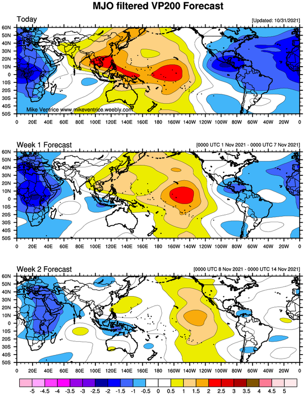
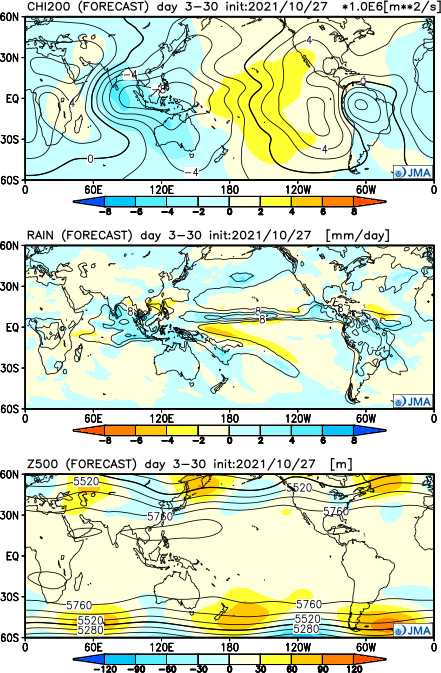
With the formation of Subtropical Storm Wanda, the lull of activity is officially over because a bona fide La Niña pattern is present. It took a while for a La Niña pattern to settle, but it has. Mike Ventrice forecasts a La Niña pattern to continue into mid-November, and the JMA forecasts the pattern to continue throughout the month of November. The lack of activity in the Atlantic was purely a result of the Madden-Julian Oscillation being in unfavorable phases. The GFS forecasts Caribbean development around November 5, East Coast development around November 7, Gulf of Mexico development around November 8, more subtropical development on November 13, and development near the Iberian Peninsula on November 14. The CMC tells a similar tale.
0 likes
-
tolakram
- Admin

- Posts: 20186
- Age: 62
- Joined: Sun Aug 27, 2006 8:23 pm
- Location: Florence, KY (name is Mark)
Re: 2021 Indicators: SST's / SAL / MSLP / Shear / Steering / Instability / Sat Images
AlphaToOmega wrote:With the formation of Subtropical Storm Wanda, the lull of activity is officially over because a bona fide La Niña pattern is present. It took a while for a La Niña pattern to settle, but it has. Mike Ventrice forecasts a La Niña pattern to continue into mid-November, and the JMA forecasts the pattern to continue throughout the month of November. The lack of activity in the Atlantic was purely a result of the Madden-Julian Oscillation being in unfavorable phases. The GFS forecasts Caribbean development around November 5, East Coast development around November 7, Gulf of Mexico development around November 8, more subtropical development on November 13, and development near the Iberian Peninsula on November 14. The CMC tells a similar tale.
https://i.postimg.cc/hPNqMMVG/twc-globe-mjo-vp200.png
https://i.postimg.cc/Vkyk5zG4/Y202110-D2712-gl0.png
I disagree, I think there was more to it otherwise what happened wouldn't be so rare.
5 likes
M a r k
- - - - -
Join us in chat: Storm2K Chatroom Invite. Android and IOS apps also available.
The posts in this forum are NOT official forecasts and should not be used as such. Posts are NOT endorsed by any professional institution or STORM2K.org. For official information and forecasts, please refer to NHC and NWS products.
-
Category5Kaiju
- Category 5
- Posts: 4336
- Joined: Thu Dec 24, 2020 12:45 pm
- Location: Seattle during the summer, Phoenix during the winter
Re: 2021 Indicators: SST's / SAL / MSLP / Shear / Steering / Instability / Sat Images
1 likes
Unless explicitly stated, all information in my posts is based on my own opinions and observations. Tropical storms and hurricanes can be extremely dangerous. Refer to an accredited weather research agency or meteorologist if you need to make serious decisions regarding an approaching storm.


Re: 2021 Indicators: SST's / SAL / MSLP / Shear / Steering / Instability / Sat Images
Category5Kaiju wrote:https://twitter.com/philklotzbach/status/1454949062956904448
Ok, I am now officially very confused.
Okkkkaayyyyyy what? Yeah something is definitely up.
Just my thoughts but...this may have something to do with it.
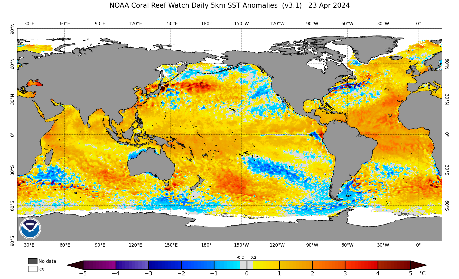
Notice how the anomalous warmth is primarily focused in the subtropics, robbing the deep tropics of instability globally. This is something that I know has been talked about for the last couple years but I think this year really hammers in the point that with the subtropics warming, global tropical activity patterns could be changing and may already be changing. Notice how the only tropical entity on the entire globe is in the subtropical Atlantic. This may prove the point, all though we need more extensive research to prove that this is happening...and more time.
0 likes
Who is online
Users browsing this forum: No registered users and 196 guests